
The Fra Mauro map (mid-15th century) provides a rare lens into the geographical worldview and mental landscapes of the medieval world. By connecting identifiable geography from this map to historical place names, we have begun to discover lost, medieval cities in Ethiopia. Scholars long considered Africa the least reliable portion of the Fra Mauro map. It is the contention of this article, however, that implementing a more Afro-Arabian geographical framework resolves apparent idiosyncrasies to the western mind, revealing a compelling story long hidden in plain view. Untangling the region of Abassia Ethyopia requires interpreting the physical features and polities transposed upon the map through the worldview of the informants from these respective regions: emissaries, pilgrims, merchants, etc. Our hypothesis asserts we can translate images of the medieval geography through the centuries to locate archaeological features. Using remote-sensing in conjunction with other early maps, we identified sites of long-lost cities such as Sadai and Tegulet, and via field-walking, have confirmed substantial architecture and period-specific cultural materials. Our continuing research traces patterns of land-use across landscapes, identifying phases of occupation and trade networks during Ethiopia’s poorly understood medieval periods. Having now created a template for interpreting this map, we expect to be able to read and understand other regions in Africa. Indeed, the Fra Mauro map has proven more than the fanciful rendering of a medieval mind. Rather, it is the “before” snapshot of a Mappa Mundi, that literally turned our view of the world upside down within a single generation, and eventually expanding it by four new continents.
The Fra Mauro Map: An Icon of Medieval Mental Landscapes at a Pivotal Point in History
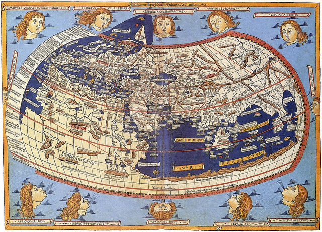
Maps serve as temporal, mental constructs of any given age. As graphic symbols for visualizing the world, each literally represents a product or icon of one’s respective worldview, in essence, the world made in our image. Medieval maps served very different functions than our current, science-based demands. Medieval navigators and, therefore cartographers, focused primarily upon safe passage, trade networks, and political alliances. Most maps contemporary with Fra Mauro depended wholly upon the Ptolemaic model, or were tied to a cosmography of Christ as Pantocrator reigning supremely from his heavenly throne (See Fig 2) (Falchetta, pp 57).
________________________________________
This Ptolemaic map is a later rendering showing the Indian Ocean as an inland lake. https://upload.wikimedia.org/wikipedia/commons/f/f0/Claudius_Ptolemy-_The_World.jpg
_________________________________________________
Fig. 2 – http://www.bl.uk/learning/timeline/item99816.html
______________________________________
In sharp contrast, the Fra Mauro map diverges from this mindset, using an empirical, verifiable framework, gleaned from existing accounts and charts. Most Christian or western maps from this period centered around Jerusalem with east at the top. Muslim maps traditionally were south-oriented given most medieval Muslims lived north of Mecca, the center or qiblah for pilgrimage and prayer. As a masterpiece of medieval cartography, the mid-15th century Fra Mauro map provides a rare lens into the geographical mindset and mental landscapes of one of the most critical transitions in Mediterranean history (Cattaneo, pp.123). Also southern-oriented, the genius of this Venetian monk in collecting maps and compiling written and oral primary accounts of travelers, merchants, pilgrims, and emissaries, creates a remarkably accurate planisphere representation of our world. Fra Mauro sketches his map not simply to expedite navigation or exploration, rather, to lay the foundations for a new world order.
______________________________________
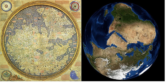
Fig. 3 – Note: this image is inverted from our typical perspective with south at the top. Europe and the Mediterranean, on the right, are more clearly defined – https://landsat.gsfc.nasa.gov/fra-mauros-mappamundi/
_________________________________________
In the contentious contexts of the mid-15th century, this map lays out a “Who’s who” of the medieval world. Like an intricate, medieval Risk gameboard, the cartographer’s draftings of geographical features, regional and city names, and trade routes, across his mappa mundi, identifies possible alliances alongside real and potential threats. Anything Christian, even the thinnest web of connection, is emphasized. Every city stands fortified, bounded by copious notes on regions, rulers, rivers, and where gold, spices, pearls, and fresh water can be found. Unnamed walled villages (casali) bristle across landscapes. Mountains feature prominently throughout. Passes or rivers clearly bisect the landscapes, demarcating regions and polities. Ships, identifiable with the contemporary, dominate traders, ply their respective seas.
_________________________________________
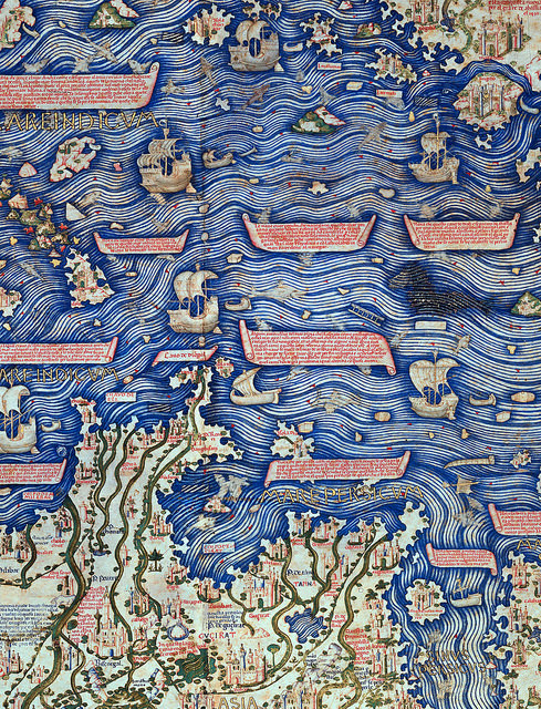
Fig. 4 – Detailed excerpt of Indian Ocean shipping and southern India from the Fra Mauro Map. Image courtesy Marco Vigano
______________________________________
Mental Landscapes of Medieval Africa
With the sacking of Constantinople in 1453, the migration of Byzantine refugees to Europe swells to a flood. From this pinnacle of learning come architects, artists, engineers, cartographers, and scholars, carrying not only tools of their trade, but an alternate world view framed by principles of an empirical perspective. Like midwives, these intelligentsia from around the world, including the far-too-often, underrepresented regions of Africa, help birth a new scientism in Europe, of which Fra Mauro is a product.
Modern scholarship has long considered Africa the least reliable portion of the Fra Mauro map (Falchetta, pp.94). It is the contention of this article, however, that by exploring and implementing a more Afro-Arabian geographical perception, apparent idiosyncrasies to the modern mind resolve, revealing a compelling story long hidden in plain view. A re-assessment of the geographical and political representations on the African continent, especially the various Ethyopias and the “island” of Diab, demands we appreciate and honor the vantage-point and geographical knowledge of Fra Mauro’s respective African informants.
Fra Mauro’s Ethiopian, Arabian, and East African informants would undoubtedly exhibit an abundance of caution along with a fundamentally diverse worldview in transmitting geographical information. Medieval Ethyopia Abassia’s reticence in divulging too much information is rooted in a preservation mentality, seven centuries in the making. Surrounded by adversaries, the Christian kingdom of Abyssinia has long maintained its near-monastic solitude, safeguarding its identity as the authentic church. The myths and legends of the Kebra Negast, known in English as the Glory of the Kings, grow deeper, entrenched in the Ethiopian psyche. Claiming direct descendancy from Israel’s King Solomon via the Queen of Sheba, along with St. Phillip’s conversion of Queen Candace’s eunuch as the first Ethiopian Christian, Abyssinia visualizes itself as the new, chosen-people of God. Comparatively, what this younger, diaphysite, western church might proffer appears inconsequential.
During the early medieval period, it is the west that initially courts Africa. For three centuries, the legends of the famed Prester John have fermented in the medieval mind, intoxicating the courts of Europe with stories of wealth, military power, and a biblical, spiritual lineage second only to Christ. By the mid-14th century, the futile search for this monarch in Asia turns its focus to Africa, where, due to Ethiopia’s intermediary trading position, exporting trade goods from India to Europe, Ethiopian kings are often misidentified as kings of India (Van den Bosch, 2007, pp.22). Fra Mauro inscribes references to the legendary king, Prester John, across Abassia, even to mentioning his capital and the number of kingdoms under his Lordship.
In contrast, embassies from Abyssinia-Ethiopia visiting Venice in the 1430’s, and Florence in 1441, seek relics and icons over mere political or religious alliances (Falchetta, pp.98; Siebold, Monograph #249). One can easily imagine various diplomats and our monks plying these illustrious pilgrims with wine and questions regarding geography, political boundaries, trade networks, and allegiances. Over the following decade, further information is gleaned, eventually making its way onto a map that will literally turn the way we imagine our world upside down.
The political and geographical information on Abassia, or Abyssinia-Ethiopia, is disproportionately represented in relation to other parts of Africa for two primary reasons. First, given their respective Christian ties, Fra Mauro and his colleagues enjoy far more contact and therefore, primary accounts from informants of these regions than from southern, central, or western African communities. Second, informants upon the Swahili Coast, in the 13th – 14th centuries called the Daybuli, consisting of African trade cities established by Muslim-Arab conquerors from India (Davidson,1967, pp.99), appear reticent to divulge information of their particular region to a competing, foreign, non-Islamic power. Understanding these factors proved essential in reading and unlocking the secrets of what appears an arbitrary, even nonsensical southern African geography.
Fra Muaro’s World Within a Gilded Frame
Fra Mauro defends the reliability of his African primary sources as justification for expanding upon Ptolemy’s terra incognita. Inscription number *98 regarding these regions informs our scholarship, “Because to some it will appear as a novelty that I should speak of these southern parts, which were almost unknown to the Ancients, I will reply that this entire drawing, from Sayto (Assiut, Egypt) upwards, I have had from those who were born there. These people were clerics who, with their own hands, drew for me these provinces and cites and rivers and mountains with their names; all these things I have not been able to put in due order for lack of space” (Falchetta, pps. 210-203).
Fra Mauro’s paramount intent is reliability and authenticity to an expanding body of knowledge. Yet bound by the parameters of his parchment and wishing to be faithful to his latitudinal and longitudinal constraints, he states, “I do not think that I am being unfaithful to Ptolemy if I do not follow his Cosmography, because if I had wanted to observe his meridians, parallels, and degrees, I would have had to omit many provinces within the known part of the world that Ptolemy does not give: everywhere in his account, but especially to the north and south, he gives areas as terra incognita because in his day they were not known” (*2892 – Falchetta, pp. 711).
__________________________________________
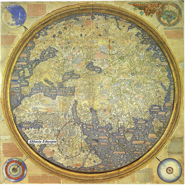
Fig. 5 – Note: This map is inverted from its original for ease of reading. The enclosure indicates direct governance according to Fra Mauro’s informants. Other inscriptions indicate tributary allegiances across the continent. https://upload.wikimedia.org/wikipedia/commons/1/1b/FraMauroDetailedMap.jpg
_________________________________________
For reasons stated above, the further south the cartographer ventures, the less information is available. Fra Mauro defends himself against claims that he does not follow Ptolemy, by paraphrasing the ancient geographer, “one can only speak correctly of regions that are visited continually; of those which are less frequented no-one should think himself capable of speaking with equal accuracy.” Fra Mauro continues, “So I say that in my own day I have been careful to verify the text by practical experience, investigating for many years and frequenting persons worthy of faith, who have seen with their own eyes I faithfully report above” (ibid, pp. 701). Fra Mauro evidently feels justified to move beyond the constraints of existing scholastic mindsets.
Our current research has likewise benefited from this vantage point, aided by an Afrocentric, indigenous frame of reference and many newly translated manuscripts from these regions and periods. We too have attempted to carefully “verify the text by practical experience” as we continue to investigate on the ground what we have seen with our own eyes. Our investigation has confirmed the surprising completeness and accuracy of Fra Mauro’s research. In more southern regions, we accounted for cultural, economic, and political factors while recognizing a necessary shift in orientation, imposed by the limit of his parchment space.
Approaching the upper, southern margins of his parchment with regions yet to be included, the cartographer is forced to sketch these further reaches of Africa via shifting everything east. Recognizing the inevitable inaccuracies in his degrees in longitude, he chooses rather to favor completeness. We will come back to the operative words “in due order for lack of space.”
Translating Fra Mauro: a Cartographic Rosetta Stone
The nature of most medieval maps dictates we interpret each through a broader Ptolemaic or ecclesiastical metanarrative. In contrast, Fra Mauro’s golden frame encompasses the medieval world within the broader, regional, mental-constructs laid out above. Armed with this perspective, our team began reading our current Ethiopian landscapes through the flat iconography portrayed in the early renaissance style of Fra Mauro. Rivers and mountains of varying hues designate the major physical features enfolding respective medieval provinces and kingdoms. Five centuries on, this geography still broadly defines Ethiopia’s current regions and states, distinguished by factors of language, cultures, and religious expressions. Cities within these regions, illustrated as turreted towns, lay along trade routes.
_________________________________________
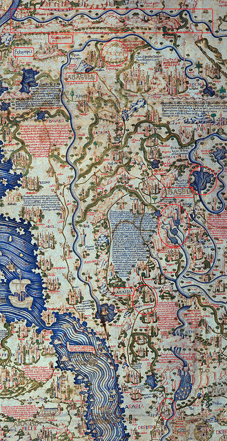
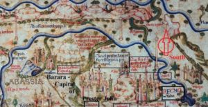
Fig. 6 – Excerpt of Fra Mauro of Ethyopia Abbasia showing geographical and political features.
____________________________________
Our initial task in untangling the provinces of Abassia Ethyopia, writ large across most of central and east Africa, required recognition of identifiable geographical features and polities transposed upon the map by reputable Afro-centric clerics, scholars, and representatives of these regions. Starting from Egypt’s first cataract at Sua (Aswan) near Nuba or Nubi, we traced mountain ridges and rivers up to the southern reaches of Abyssinian hegemony referred to as Ethyopia quasi deserta e montuosa. An arbitrary river with a line of forest on either side demarcates regions south of direct Ethiopic governance. Within Abyssinia-Ethiopia, discernable rivers, mountains, kingdoms (Regnos), or provinces and cities, include Aksum in Tigray (hacsum, tegre) and the four tributaries of the Tekeze river streaming from the mountain of Roha. The map clearly defines Lake Tana and Abay, Ethiopia’s name for the Blue Nile. Further south, the geographical features of the Awash river (fl. Ausai) with Mt. Zukwala and lake Zwai (xiauala ouer xiquala & lago zuua) circumscribe Prester John’s suzerainty of African Christendom under the oversight of the Metropolitan of the Alexandrian Coptic church.
Having oriented ourselves, we then attempted to “translate” the Fra Mauro map, much as an epigrapher would an ancient inscription. Like a cartographic Rosetta Stone, moving from the known to the unknown, we collected images of subsequent medieval maps in an attempt to decipher the conceptual content and mental landscapes of represented physical geography through successive shifts in political, religious, or economic paradigms. Throughout, our noted geographical features remained constant. Topographies represented on medieval maps, such as lakes, rivers, and mountains, evolved into discernable landmarks and observable landscapes on modern maps. Slowly, like a developing embryo, we witnessed these morph from medieval icons into recognizable place names of regions, cities, or trade routes.
Our final test sought to read our current landscapes back through the centuries and interpret the physical geography seen and described by mid-fifteenth century Ethiopian monks and emissaries to a Venetian monk who then transcribed them on a two-meter piece of parchment thousands of kilometers and a few cultures and languages removed. To crack the code of the Fra Mauro map in regard to our regions, to say nothing of south and central Africa, we had to try.
_______________________________________

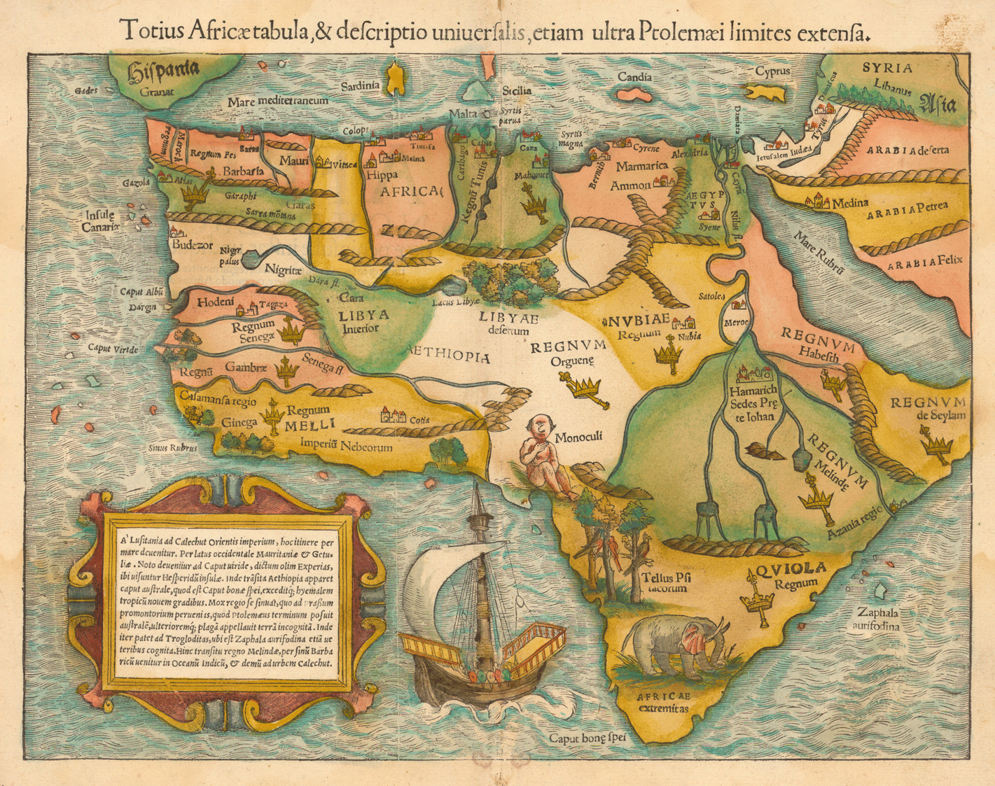
Fig. 7 – Munster, 1554 – https://libweb5.princeton.edu/visual_materials/maps/websites/africa/maps-continent/1554munster.jpg
_______________________________________
Our first hurdle required we demythologize the majority of maps from the subsequent centuries which retained much of the fanciful Ptolemaic narratives and mythical topography of Africa’s interior, including cyclops, fabled beasts, the Mountains of the Moon, and of course, Prester John. Ironically, these maps were to provide invaluable clues in addressing one of the major debates related to the interpretation of the Fra Mauro map and Africa, that of the “island” of Diab.
The second hurdle involved geopolitical ramifications wrought by decades of war in the middle of the 16th century. Regional conflicts left desolation to both sides. Many of the main population centers and trade routes depicted on the Fra Mauro map simply ceased to exist. Where once thriving, urban centers dominated, sparse villages dotted the landscapes. In the highlands, new population centers with new names replaced anything old. By the end of the 17th century, the memory of the raging conflicts between the Islamic forces of Imam Ahmad, known as Ahmad Gran or the left-handed, and the variably named Christian kingdom of Shoa, Xoa, or Sewa, had cooled to an uneasy, smoldering detente. Yet these wars had prompted mass migrations of populations followed by the influx of new cultures and languages (Newman, pp. 99). A shifting of place-memory displaced most previously associated oral traditions. Alternate land use and new agricultural practices swallowed up previous occupational contexts. Most associated religious structures, along with their treasures of relics and manuscripts, also perished, usually via fire. The loss of contexts with which to even begin to identify lost cities was exacerbated by a paucity of scholarship related to these eras. Undaunted, we pressed on.
_________________________________________
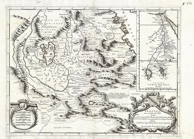
Fig. 8 – Coronelli, 1690 – https://upload.wikimedia.org/wikipedia/commons/3/3f/1690_Coronelli_Map_of_Ethiopia%2C_Abyssinia%2C_and_the_Source_of_the_Blue_Nile_-_Geographicus_-_Abissinia-coronelli-1690.jpg
__________________________________________
The earliest map that proved critical in framing the rugged landscapes of Abyssinia’s identifiable mountain ranges, passes, and rivers, along with cities in associated regions, was the 1690 Coronelli map, also from Venice. This primary source provided a post-medieval perspective on our tangible topography. The mountains that had defined medieval political states continued to limit expansion. Like words borrowed from an archaic vocabulary, Coronelli’s mountains helped us translate a matching political narrative, back to Fra Mauro’s century-and-half-old geography, and its original African mindset. Corresponding geographical features provided our first key to unlocking locations of long-lost cities on the Fra Mauro map.
__________________________________________
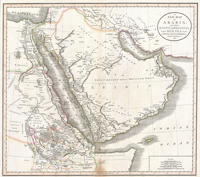
Fig. 9 – Cary Arabia and Abyssinia map, 1811 – http://www.raremaps.com/gallery/enlarge/33908
____________________________________________
The 1811 Cary map provided us our next series of clues. With each century, the earlier artistic mythologies gave way to a more realistic physical geography. Regions and political entities remained bounded by the strictures of observable landscapes. Connecting rivers or mountains on an 1811 map to rivers and mountains etched on a 1690’s map, we translated back to the 1450’s map. Thus, we were able to “read” the conceptualized landscapes through time and, more importantly, through a medieval mind’s eye.
____________________________________________
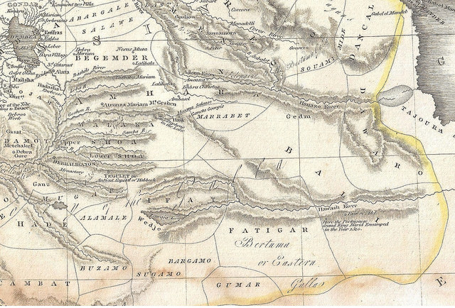
Fig. 10 – Section of Pinkerton, 1818 – https://commons.wikimedia.org/wiki/File:1818_Pinkerton_Map_of_Nubia,_Sudan_and_Abyssinia_-_Geographicus_-_Abyssinia-pinkerton-1818.jpg
____________________________________________
Pinkerton’s 1818 Abyssinia & Nubia map traces the upper Nile. The odd and inaccurate orientation of the mountains of Shoa, however, caught my eye. The cartographer appeared to have regressed to an earlier time where mountains could arbitrarily be drawn upon a map for aesthetic purposes rather than indicators of true landforms. This led me to reassess Pinkerton’s abstractions of depicted mountains surrounding Ifat, Fatagar and southern Abassia, and subsequently to reconsider and weigh analogous geographical or conceptual biases all the way back to the Fra Mauro map.
Since Pinkerton’s focus is hydrology, his mountains appear drawn as merely presumed necessary elements to funnel water from the highlands to the Nile. Fra Mauro’s emphasis, on the other hand, frames the boundaries of regional hegemonies and trade networks of an ancient and wealthy kingdom determining potential alliances, trade, and partnerships for the future. Whereas Pinkerton’s mountains seem practically superfluous, Fra Mauro’s mountains represent physical barriers to commerce or conquest, and inviolable boundaries between friend and foe.
____________________________________________
Fig. 11 -Kautx, 1868 – https://www.bigstockphoto.com/image-26737070/stock-photo-old-map-of-abyssinia-with-red-sea-region-map-insert-created-by-kautx-and-gillot,-published-on-l-illustration,-journal-universel,-paris,-1868
___________________________________________
The final piece to our puzzle came with the 1868 Kautx map showing substantial elements of geography recognizable to a modern map reader. Many of the details on this map are sourced in an episodeall but forgotten episode in the west: the British Napier Expedition against the Emperor Tewodros in 1868 (Sharf). For Ethiopians, however, this event defines the critical juncture of Ethiopia’s emergence into the modern era. On Kautx’s map, the political names and physical-geographical features we previously observed, had gestated from fanciful images, into recognizable place names of cities, lakes, rivers, and mountains. Through four centuries, our maps, like Ethiopia itself, had entered the modern era.
A Tale of Two Lost Cities: From Google Earth to Artifacts on the Ground
Now came the challenge to test our hypothesis. Could we physically locate and discover a medieval site listed on the Fra Mauro map, but long-forgotten and lost for centuries? Could we read the physical geography of our current landscapes and then interpret back through the centuries the actual landscapes as described by mid-fifteenth century Ethiopian monks and emissaries to a Venetian monk? To crack the code of the Fra Mauro map pertaining to Abassia and south and central Africa—again, we had to try.
_____________________________________________
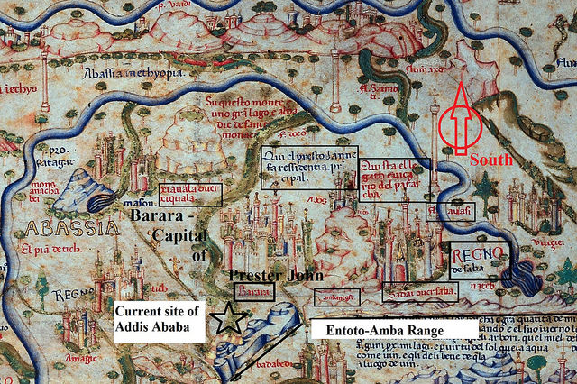
Fig. 12 – Southern Abassia section of the Fra Mauro map indicating toponomy and geographical features – Note: The southern orientation means that south is above.
____________________________________________
We selected an undiscovered site within the southern reaches of Abbasia called Sadai or Saba. It is listed under Regno de Saba (the Kingdom of Sheba and, therefore, of Prester John), as the residence of the Metropolitan sent by the Coptic Patriarch in Alexandria (Questa el legato euicario del patarcha). It lies on the west slope of a mountain called Ambanegst and south of a mountain range running east-west called the Entoto-Amba Range. It lies northeast of the Awash River (fl. Auasi), and west of the 3,000-meter volcano still called Mt. Zokwala (Xiquala). The only large mountain fitting the description for Ambanegest is now called Menagesha or Mt. Wechecha, with a small mountain adjacent where, until recently, emperors were crowned. The name Ambanegst loosely translates to “the uplift or mountain of kings.” East of this mountain, the still unidentified capital city of Barara is indicated as the principal residence of Prester John. We have a candidate for this site, but it remains off limits. Note: the map above is inverted from our normal orientation.
Fra Mauro illustrates Sadai hugging the western slope of Mt. Ambanegst. I searched Google Earth for locations fitting our parameters. And there it was: large, circular fortifications upon a knoll overlooking the entire western and much of the southern frontier. Clear evidence of architectural features accompanied by crop marks indicated possible occupation over an area extending several kilometers square. Sadai had been one of the first cities destroyed in 1530 by the marauding forces of Imam Ahmad Gran. None of our subsequent maps contain any mention of this ecclesiastical capital. Since we had no possibility of cross-referencing its location, we elected to physically visit the site and hopefully confirm what we were seeing on images.
___________________________________________
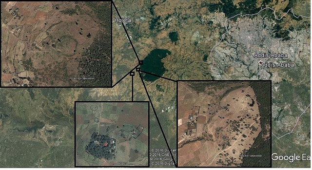
Fig. 13 – Google Earth image with identified sites associated with Sadai – on the west slopes of Mt. Menagesha/Wechecha or Ambanegst
___________________________________________
Managing a team from the College of Development Studies at Addis Ababa University, we visited the southern-most identified features, and walked north. Cultural material and architecture were immediately evident upon our transects across an area of several hundred meters. Thinking like medieval strategists, we moved from high-point to high-point, noting walls of ashlar masonry (carved stones), fieldstones, even evidence of earthen bulwarks and moats or ditches. Every footfall evidenced urban habitation.
___________________________________________
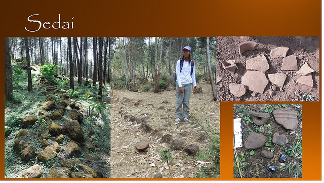
Fig. 14 – Sadai – Architecture and Cultural Material – (Photo credit – SCW)
___________________________________________
Eventually, we identified three substantial occupational areas and a possible fourth distinct fortification site. Each contains dense period-specific cultural material and architecture, with corresponding monumental walls containing varying stages or phases of occupation. Immediately south upon an isolated hill, lies a possibly related church complex where we discovered a series of pre-Christian funerary monuments with inscribed, monumental stones, deliberately toppled stone stelae, and a series of well-built, rectangular, architectural elements. The current church sits atop a much larger, older foundation. Medieval pottery remains in-situ in cuts along the road to the church.
Local farmers and a church deacon gave us various renditions of stories related to the sites, referring to the areas south as Sada, or north as Sabu, similar to Fra Mauro’s Saba. The sites upon the forested slopes they simply refer to as “the walls.” In asking for a translation, we were told Sadai is the local word for standing stones, or stelae, precisely like the desecrated ones identified in the ancient, pre-Christian cemetery. This was our Eureka moment; a previously un-identified site, fitting the descriptions on the Fra Mauro map, containing substantial architecture and quantities of medieval cultural material spread over an eight kilometer transect. Additionally, an ecclesiastical capital required an adjacent major church. The small modern church is built upon the substantial ruins of a much older and larger church.
Convinced now of the tenability of our hypotheses, I returned to our collections of historical and modern maps. I sought hints to validate this as our candidate. Upon each map, I traced feasible trade routes, constraining topographical features, and traveling distances between identified sites and settlements against associated geographical landmarks. I evaluated geology and soil types, rainfall patterns, hydrological data, and vegetation potentials in relation to relief maps. All these data affirmed, this must be Sadai.
This process of discovering Sadai provided a key whereby we could unlock the location of other lost cities. We followed discernable trends as they echoed repeatedly across the centuries. Specific physical features consistently restricted the parameters of trade into and out of the highlands. At strategic choke points, we found ruins of medieval fortifications. Upon protected, defensible ridges with sufficient access to water and agricultural soils, yet close enough to trade routes, larger population densities were secreted away.
I then had an epiphany—it was a technological shift in the tools of war that generated the biggest alteration in occupational patterns. The introduction of the musket and cannon in the early 16th century radically altered the parameters of what constituted defensibility. More than any other factor, gunpowder rendered moats and wooden palisades inconsequential. Prior geopolitical criteria determining strategic positions for earlier medieval sites and fortifications became obsolete. Adding this new variable to our equation enabled us to create an invaluable template of where pre-16th century sites should be situated.
As if on cue, another long-lost city, Tegulet, asserted its presence. All place-memory of this medieval capital had vanished. Though it is mentioned throughout the medieval period as the capital of Abyssinia, its location remained a mystery. Utilizing the remote sensing methodology we had devised, and adding our new variable, we narrowed our search to a series of ridges along the Jemma River drainage basin, west of the ancient trade routes and north of Debra Berhan, the new city established by Emperor Zara Yaqob in 1456.
___________________________________________
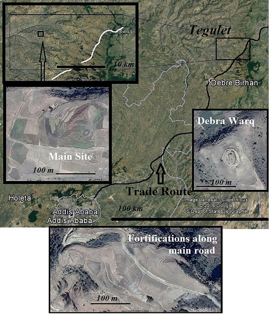
Fig. 15 – Tegulet overview – Google Earth images
___________________________________________
Within less than twenty minutes of scanning images on Google Earth, given our set parameters, we had identified three possible candidates for occupational-sites with probable architectural features. Hopeful, we again ventured forth for a two-day excursion with a team from Addis Ababa University. Driving along the main ridge we had identified, we inquired of locals and were told the place was called Addis Ga, “the New Place.” So, there had been an “old place” somewhere nearby. Another name repeatedly given was Debra Warq, “the Hill of Gold.” A designation of Tegulet was never volunteered. Eventually we inquired, “Have you heard of Tegulet?” Most gave a shrug or mentioned a region at the end of the valley by that name, yet no one knew for sure. A bit disappointed, we continued walking west, descending the narrow ridge toward our main sites, ten and twelve kilometers further west.
Less than a kilometer in, atop a flat plateau to the north, we discovered our first evidence of architecture comprised of a double coursing of monumental stones. Just beyond, the track dropped along a narrow escarpment, where oddly, a road had been carved into the hillside. At the base of the cliff, the road continued with pavers imbedded in the earth. Three hundred meters further, where the road ascended a slight slope, the bedrock showed evidence of ruts cut by wheeled vehicles over a period of perhaps several centuries.
____________________________________________
Fig. 16 – The “Royal Road”: left- ruts; center- the pavers; right- terraced road. Note, the left terrace is modern. (Photo credit – SCW)
____________________________________________
In medieval Ethiopia, there is no record of wheeled vehicles, carts, chariots, or the like. Yet, we followed an obvious, built-road, wide enough for two vehicles with axels 185 cm, to the main site, a full ten kilometers along the ridge. In the fields all along the route, medieval cultural material abounded. When asked, our informants replied that similar things could be found in heavy concentrations further down the ridge.
____________________________________________
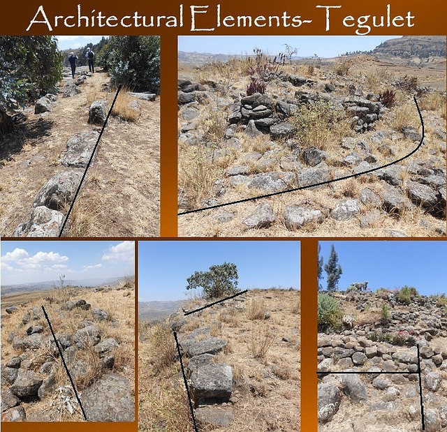
Fig. 17 – Linear and circular architectural elements at Tegulet – (Photo credit – SCW)
____________________________________________
Two hard days of trekking produced ample proof this was indeed an area containing all the hallmarks of a substantial, if not royal medieval site. We documented five main areas containing dense concentrations of cultural material including pottery fragments, stone tools, cores, flakes, and iron slag. Architectural features including walls, towers, enclosures, and stone alignments, and stone abrading tools used for preparing manuscripts, along with debitage from semi-precious stones such as carnelian, jasper, agate, chalcedony, and corundum – used in jewelry, book covers, and vestments – were also discovered. Many seeps or small springs percolated sufficient water for year-long irrigation and for livestock. Locals retained no place memory of these sites; to them, these old places had simply always existed.
In reading Burton’s First Footsteps in East Africa for our desk-based analysis, I came across various accounts of Tegulet and the conflicts during the Imam Ahmad Gran wars of the late 1520’s through 40’s. Burton claims that much of the kingdom of Shoa was conquered by Islamic forces in 1528 accompanied by much destruction by fire (Burton, vol. II, pp.5). A century earlier, in 1456, Emperor Zara Yaqob established the new city of Debre Berhan, a mere 23 kilometers south of our proposed research area—this town of course appearing too late for the Fra Mauro map. Additionally, Tegulet is mentioned as the launching point of Emperor Amda Sion (1312-1342) against the lowlands of Adel and Ifat (Burton, vol. II pp.3-4). Emperor Alexander (reigned 1478-1495) was assassinated in Tegulet by his complicit bodyguard, forcing his successors, Naud and Dawit or David III, (died 1540) to live encamped in transient sites supported by the newly arrived Portuguese, engaging in conflicts with Imam Ahmad Gran, (ibid, pp. 6).
Burton relates one final intriguing episode. After the death of Imam Ahmad at the hands of the Portuguese (1543), Emperor Claudius began rebuilding a site known as Debra Warq, “a celebrated (Christian) shrine” destroyed by invading Islamic forces (ibid, pp11). He was killed in battle (1559) before completing the goal. While there are many sites with this name, at the furthest point upon our research ridge sits a ruin called Debra Warq with evidence of an extremely intense fire. The very soil itself still retains a burnt aspect a full five centuries on. Fire-cracked rock and elements of vitrification strew the landscape.
___________________________________________
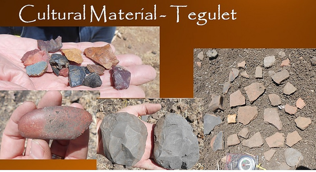
Fig. 18 – Tegulet cultural materials collection: top- flakes and debitage; lower left- abrasion stone for vellum preparation; center- early choppers; right- pottery shards from the main occupation site gathered in an area covering 25 meters. Photo credit – SCW
_____________________________________________
These data: historical accounts, the “royal road”, the ubiquitous period-specific cultural material, the monumental architecture, the semi-precious stones, the iron slag, the affects of intense fire, combined as confirming evidence that we had indeed found our site. Our second eureka moment in as many weeks, painted an intriguing, rich narrative lost in history—the forgotten grandeur of a medieval kingdom hidden beneath the contemporary demands of a developing nation.
These discoveries provide a promising beginning. In our exploration, no day is ever routine. Using our research template, we continue seeking lost cities and ruins strewn across Ethiopia’s magnificent and varied landscapes. Daily we are tantalized with Ethiopia’s secrets. With every footfall, the ground seems to reverberate this noble history’s sheer will to be reborn. Starting from the ground up, our team continues to actively pursue partnerships to enhance our remote sensing and comprehensive field-walking surveys, and bring others along this journey of discovery.
Regarding our regions in Africa then, it appears the Fra Mauro map has proven itself far more than the fanciful rendering of a medieval mind. It is indeed a prescient icon or a Mappa Mundi that launched thousands of ships which literally turned our view of the world upside down within a single generation, eventually expanding it by four new continents. As for us, we have set our sights to disentangle other regions in Ethiopia including the unnamed cities on the southern border of Abassi. We are also well on our way to implementing our methodologies and creating partnerships with hopes we can eventually address the mysteries associated with the “island” of Diab.
A Call for More African-based Research
Questions inevitably remain pertaining to the poorly understood, yet complex subjects relative to broader ancient and medieval studies. Historical, cultural, and geographical connections across the Southern Red Sea, the Indian Ocean, and the Eastern Mediterranean remind us of the larger and deeper significance Ethiopian history and heritage holds for our world. The mysterious, forgotten past that paint Ethiopia’s landscapes in myriad colors of the impossible, inspire us. The brilliance of these varied, interred ancient and medieval empires whisper their faded splendor to those who still intently seek it.
Our hope remains that we can initiate a series of broader conversations by creating greater access to the literature from these regions, thus informing and building a network of scholarship which utilizes all the resources available to us. We wish to create partnerships with local scholars across our regions and begin asking new questions, tying our respective medieval periods together beyond the artificial standards of comparisons based upon modern economic or religio-political terms. To better understand our commonality and connectivity beyond modern or traditional boundaries, we must validate and honor indigenous self-perceptions within historical, national, and individual frameworks. All will benefit from the cross-pollination of worldviews originating within this wide-ranging, local historical discourse.
Through the auspices of St. Mary’s University in Addis Ababa, Ethiopia, we continue our research and discovery. Our goal is to present our finds while working alongside other professionals, institutions, agencies, and governmental organizations to create indigenous capacity and trained scholars to advance research and tourism potential within Ethiopia and the broader region. The next steps require creating desk-based analyses for each site and to conduct comprehensive field-walking surveys to include sub-surface/geophysical survey and remote sensing analysis. Upon completion of this phase, our goal is to preserve, present, and promote these newly discovered cities to the world, opening them up for further research, training, and tourism development.
___________________________________
For questions, comments, or clarifications, please contact the author at: [email protected]
___________________________________________
Bibliography
-Brotton, J. ed. Great Maps – The World’s Masterpieces Explored and Explained, DK Publishing, 2014.
-Burton, R. F. First Footsteps in East Africa or An Exploration of Harar, Dover Publications, Inc. 1987.
-Cattaneo, A. Terrarum Orbis 8 – Fra Mauro’s Mappa Mundi and Fifteenth-Century Venice, Brepolis, 2011.
-Davidson, B. The Growth of African Civilizations- East and Central Africato the Late Nineteenth Century, Longmans, 1967.
-Davidson, B. The Lost Cities of Africa, An Atlantic Monthly Press Book – Little, Brown, and Co. 1959.
-Dudd. R. E. The Adventures of Ibn Battuta – A Muslim Traveler of the 14th Century, University of California Press, 1989.
-Edson, E. The World Map 1300-1492 The Persistence of Tradition and Tranformation, The Johns Hopkins Univeristy Press, 2007.
-Falchetta, P. Terrarum Orbis 5 – Fra Mauro’s World Map, With a Commentary and Translation of the Inscriptions, Brepolis, 2006.
-Hibbert, C. Africa Explored – Europeans in the Dark Continent 1769-1889, Penguin Books, 1984.
-Hugh, C, ed. (1911). “Unyamwezi“. Encyclopædia Britannica. 27 (11th ed.). Cambridge University Press. pp. 781–782.
-Newman, J. L. The Peopling of Africa – A Geographic Interpretation, Yale University Press, 1995.
-Pearson, M. N. Port Cities and Intruders – The Swahili Coast, India, and Portugal in the Early Modern Era, The Johns Hopkins University Press, 1998.
– Sharf, F. A. Abyssinia 1867-1868: Artists on Campaign, McMullen Museum of Art, 2007
– Van den Bosch, G. Maps on the legend of Prester John, BIMCC Newsletter No. 29. pps. 19-24.2007
-Whitfield, P. The Charting of the Oceans – Ten Centuries of Maritime Maps, Pomegranate Artbooks, 1996.
-Williams, F. M. Understanding Ethiopia – Geology and Scenery, Springer, 2016.
Web Sources
– http://cartographic-images.net/Cartographic_Images/249_Fra_Mauros_Mappamundi.html (Siebold, J. Monograph #249)
– https://en.wikipedia.org/wiki/Bunyoro
– https://en.wikipedia.org/wiki/Kingdom_of_Karagwe
– (Cary 1811) – http://www.raremaps.com/gallery/enlarge/33908
– (Coronelli 1690) – http://www.geographicus.com/P/AntiqueMap/Abissinia-coronelli-1690
– Fra Mauro 1450) – https://upload.wikimedia.org/wikipedia/commons/1/1b/FraMauroDetailedMap.jpg
– (Munster, 1554) – https://libweb5.princeton.edu/visual_materials/maps/websites/africa/maps-continent/1554munster.jpg
– (NASA Comparative map) – https://landsat.gsfc.nasa.gov/fra-mauros-mappamundi/
– (Pantocrator map) http://www.bl.uk/learning/timeline/item99816.html (Pinkerton 1818) – http://www.geographicus.com/P/AntiqueMap/Abyssinia-pinkerton-1818
– (Ptolemy Map) – https://upload.wikimedia.org/wikipedia/commons/f/f0/Claudius_Ptolemy-_The_World.jpg
_____________________________________________________


