Angkor Wat: The name evokes mind-boggling, iconic, intricate temples projecting from the Cambodian jungle. Today arguably the most-visited archaeological site in Southeast Asia, it also still holds mysteries under investigation to this day and for years to come. But the Khmer civilization, of which Angkor Wat is but one representative center, also consists of thousands of temples and other structures and features on the broader landscape, many of which have been identified but remain largely unexplored and others assuredly not yet known to exist. This second installment of the Anniversary Issue showcases journalist Julie Masis’ compelling stories, published previously in Popular Archaeology, about the remains of this remarkable civilization. Through her presence in the country, she has offered a first-hand journalistic perspective on discoveries, and the views of the people involved in those discoveries. Most of the stories relate what most people don’t know about Angkor—the sites and features that have often gone unnoticed in the shadow of Angkor………….
_________________________________
Undiscovered Country
There was a deliberate geometry to how they built their city. The streets ran exactly east to west or north to south. On each city block, which measured exactly 100 meters by 100 meters, there were 4 dwellings and 4 ponds, with each rectangular pond located on the north-eastern side of each dwelling. The dwellings were erected on mounds of earth, higher than the rice fields, so they wouldn’t flood during the rainy season – and so were the roads. The temples were built of stones or bricks, and the entrance faced eastward, if the temple was dedicated to Shiva, and westward if it was dedicated to Vishnu. This urban landscape extended for 35 square kilometers – and may have been home to a million people.
This was the city of Angkor, built more than 1,000 years ago.
For years, archaeologists who studied Angkor focused on its temples – because they alone survived the centuries. Everything else – including royal palaces and ordinary people’s homes – was built of wood and vanished.
But now, archaeologists are using a tool that allows them to retrace the streets of ancient cities – by pealing away the forests that cover them. Damian Evans, a landscape archaeologist from the University of Sydney in Australia, first learned about something called LiDAR from Arlen Chase, who was the first to use this technology in archaeological research in Mesoamerica. LiDAR (Laser Interferometry Detection and Ranging) is a system that uses laser pulses to reveal what the earth’s surface looks like below heavily forested areas. Chase used LiDAR in Belize to prove that the ancient Maya had built terraced agricultural fields – while Evans with his team were the first to use it in Asia. Evans’ project cost $250,000 and took 20 hours to survey 300 square kilometers around ancient Angkor. It would have taken years to clear this many kilometers with a machete.
What they found with LiDAR was staggering.
“It’s just amazing,” said Michael Coe, a world-renowned archaeologist who authored a book about Angkor. “In the case of Angkor, we knew where the temples were, but we never really knew what it was like as a city where people lived.”
In addition to creating a map of Angkor’s streets for the first time, archaeologists also found some strange coil-shaped features on the southern side of Angkor Wat – in an area that is now covered by forest and landmines. These embankments are 10-15 meters high and were created in a spiral pattern, with each bank measuring a meter in height. “We are not sure what they are,” Evans said.
One of the most important discoveries, however, was that Angkor Wat was actually bigger geographically than what had previously been thought. Evans and his team found that the city blocks extended far beyond its moat. “We found that this nicely formally planned grid extends for 35 square kilometers, rather than the 9 kilometers that had previously been mapped from the ground,” he said. “Angkor has been considered to be (among the) cities enclosed by moats or walls, but we found that the town area of the city grids extends far beyond the moat spaces.”
The implication is that Angkor was likely home to a significantly larger population than what had previously been assumed. We know, from Chinese sources, that the kings of Angkor kept censuses. Every year or two, the king would invite a person from every household in the kingdom to come to the city to be counted, according to Coe. The kings of Angkor collected this information in order to know how much they could collect in taxes each year – at the time, taxes were paid in rice. However, the census numbers were written down on paper and have not survived. Estimating the population of Angkor nowadays, therefore, is a guesstimate at best. However, knowing that the city extended for 35 square kilometers means that it may have been home to as many as 750,000 to a million inhabitants, according to the new research. “Angkor was a city the size of New York and that’s impressive in the ninth century,” said Francisco Goncalves, the president of McElhanney Indonesia, the company that adapted the LiDAR system for the Cambodian archaeology project.
Knowing this has shed new light on what may have caused the demise of Angkor. Scholars now suggest that as the city’s population grew, it likely became increasingly hard for the farmers from the countryside to support the urban dwellers. “You would have had a very large population that was not devoted to producing rice,” said Evans. “So they relied on consistent yields of the agricultural hinterland.” According to Coe, a large population may have also been responsible for the decision to move the Khmer capital to another area in the 14th century.
“They overused the land and probably caused a great amount of erosion, clogged up the canals and the whole irrigation system would have collapsed,” he said, adding that this is what happens “when populations grow beyond the agricultural capacity of the land.”
_________________________________
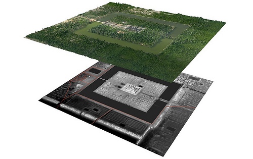
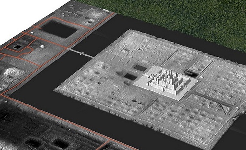
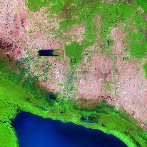
A view of Angkor Wat and its immediate environs using LiDAR. Top layer: Digital orthophoto mosaic. Bottom layer: LiDAR digital terrain model, revealing what the eye does not see. Red lines indicate modern linear features including roads and canals. Courtesy Damian Evans
_______________________________________________________________________________________________________________________
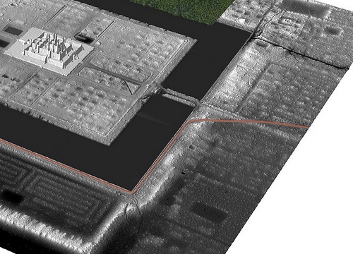
Above and below: LiDAR digital terrain model detail. Unseen ancient features come to view through the new technology. Courtesy Damian Evans
______________________________________
A Lost City
In addition to the area around Angkor itself, archaeologists also surveyed a site called Phnom Kulen hill, a 25 x 15 kilometer plateau that is located about 40 kilometers northeast of Angkor. It was on this hill that they discovered another urban landscape – a landscape they say corresponds to the 8th – 9th century city named Mahendraparvata, one of the first capitals of the Khmer Empire, identified in some inscriptions on the doorposts of Angkor. These inscriptions describe a former capital city which was established by king Jayavarman II in the year 802. It was this area that captured media attention all over the world with air segments about Cambodia’s “lost city.”
In the article that Evans and his team just published in the Proceedings of the National Academy of Sciences, they described their discovery as “an entire, previously undocumented cityscape etched into the surface of the mountain beneath the forest. This newly mapped urban landscape,” they went on to say, “was previously known primarily from written inscriptions.” However, according to Evans and JB Chevance, the program manager from the Archaeology & Development Foundation who worked with Evans on the Lidar project, the term “lost city” is actually a “misnomer.” The location of the pre-Angkorian capital has been known since the beginning of the 20th century because of the existence of dozens of temples on the Phnom Kulen mountain, including one pyramid temple that “looked very much like a royal temple of the King,” according to Evans and Chevance. But thanks to the LiDAR survey, archaeologists “moved from a situation where we had points on a map to the entire urban fabric that connects these points,” Evans said. As at Angkor, here the LiDAR was used “to see through” the cover of cashew nut plantations and forest foliage to create a three-dimensional map of the topography. The archaeologists mapped major and minor roads – stretching for 8 kilometers along east-west or north-south directions – as well as canals, dikes and ponds. The map of Mahendraparvata also confirmed the location of the 600 x 40 meter royal palace, which had been built of wood and disappeared. “With the LiDAR, we now have a very precise image of that site. It’s one of the main sites because all the roads are directed to it,” Chevance said.
In addition to this, archaeologists identified several geographically-oriented topographical anomalies that they could not identify or explain, according to Chevance. The next step will be to explore these features on the ground – not an easy task as large areas of the mountain have not been cleared of landmines.
Like Angkor, the city of Mahendraparvata was eventually abandoned, the capital moved to Angkor, and Mahendraparvata became a point of interest only for Buddhist pilgrims in the 16th century, according to Chevance. Indeed, there seems to be a tradition in Cambodia of abandoning the capital city and re-establishing it in another location. After Angkor, Cambodia’s capital moved to Lonvek in the 15th century, back to Angkor for a brief period in the 16th century, then to Oudong in the 17th century, and eventually to present day Phnom Penh in the 19th century. Perhaps, Chevance hypothesized, each king wanted to have the capital in his own hometown. Or perhaps the location of the capitals in different parts of the kingdom was testimony to the varying powers of the different royal houses, Evans said.
“People look at the movement of the royal court and imagine that it implied the movement of a large number of people,” Evans said, explaining that this is not necessarily what happened. “It could just be competing royal houses where one royal house gains power over another one.”
_________________________________________________________________________________________

Shaded relief map of terrain beneath the vegetation in the Phnom Kulen area, with elevation derived from the LiDAR digital terrain model. Green denotes previously-documented archaeological features; areas shaded red contain newly-documented features indicative of an extensive urban layout. Data and image courtesy Archaeology and Development Foundation – Phnom Kulen Program
_________________________________
Looking Ahead
Evans is currently engaged in raising more funds to continue exploring Cambodia with LiDAR. One of the locations he would like to survey is the largest enclosing wall in Southeast Asia, located in the Preah Vihear Province in the north of Cambodia. This earthen wall, called Preah Khan of Kampong Svay, is 5 x 5 kilometers in length and 40 meters tall in some areas – yet no one knows why it’s there.
“It’s huge – absolutely huge,” Evans said. “It’s kind of in the middle of nowhere.”
Archaeologists in neighboring Thailand are also becoming interested in the technology. Goncalves is looking into cooperating with Thai archaeologists to study ancient rice fields in the northeast of the country, an area now covered by forest – and to map the ancient road that once connected Angkor to the Siamese kingdom of Ayutthaya.
“A lot of that (road) has been obscured and taken over by the forest. There had to be settlements where people stopped,” he said
Overall, researchers said, Lidar will be just as revolutionary in archaeology as carbon dating – especially in tropical areas.
“Carbon dating gave us control of time, but what LiDAR does is it gives us control of space,” said Chase.
__________________________________
Article Supplement
HOW LIDAR WORKS
LiDAR uses light to measure distance. That’s according to Francisco Goncalves, of the Jakarta-based company McElhanney, the group that adapted the technology to the Cambodian archaeology project.
“You know the position of the aircraft, you know the speed of light, and you measure the time that it takes for the Lidar’s laser signals to bounce back to the aircraft,” he explains.
“The laser signals don’t actually go through the vegetation, but there are so many of them that some find gaps in the leaves and make it all the way down to the forest floor. Scientists then analyze the data sets, discarding the shorter laser signals and keeping the ones that are longest, and create a pattern,” he said.
To conduct the Cambodian LiDAR survey, Australian archaeologist Damian Evans climbed into a helicopter from which seats had been torn out to make room for computers, batteries and a special display screen for the pilot – and slowly flew in a grid-like pattern, back and forth over the ancient city.
“It’s very difficult for pilots to fly this way,” he said. “Flying by the LiDAR instrument was a bit like playing a video game – the pilot had to keep looking at this screen and keep the helicopter icon within the circle in order to keep strictly in the flight path, which is a very different way for pilots to fly.”
But the new technology is not a panacea. It has its limitations.
“While laser signals can go through vegetation, water causes a problem because it doesn’t reflect the signal back, while foggy, smoky and cloudy weather conditions make the technology difficult to use,” Goncalves said.
______________________________________________________________________________________________________________________
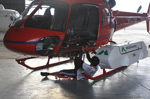
LiDAR pod being installed on the helicopter at the Phnom Penh International Airport in Cambodia. Courtesy Christopher Cromarty of McElhanney
________________________________________________________________________________________________________________________
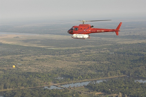
Helicopter with LiDAR attached during flight operations over Angkor in April 2012. Courtesy Francisco Goncalves of McElhanney
STUDYING ANGKOR FROM AIR AND SPACE
The temples of Angkor are spread out over such a large area, and are so perfectly symmetrical, that to truly appreciate them, it’s best to get up in the air. Nowadays, a popular way to do it is with a hot-air balloon.
But for archaeologists, it began with the aerial photograph.
At the end of the 1920s, when people first took to the sky, these photographs allowed French archaeologists to appreciate the vast scale of Angkor. “But back then, archaeologists were mostly interested in temples – not in how ancient Cambodian cities were laid out or how their irrigation systems functioned,” says Australian archaeologist Damian Evans.
Then, in the mid-1960s, came the first satellite images of Cambodia. These images were taken by American and Soviet spy satellites and were not declassified until 2003. Covering hundreds of square kilometers, satellite images widened the archaeologists’ perspective further. These pictures are particularly interesting to look at today, Evans says, because they reveal how the Cambodian landscape looked “before the Khmer Rouge messed with it.”
“Instead of respecting the remains of the Angkor period, they (the Khmer Rouge) tried to implement a whole new system of fields and canals and they tried to radically re-engineer the landscape –and they failed,” he said.
The satellite images that were taken before the Khmer Rouge came to power help present-day archaeologists to separate ancient topographic features from the more recent ones, Evans says.
Then came the first radar image, which was taken from the space shuttle in 1994. The radar stripped away some vegetation – like grasses and rice fields – but it was powerless against forests.
Finally, we have the LiDAR system, which can penetrate the thick forest canopies and allows archaeologists to create three dimensional models of the landscape under the vegetation.
_________________________________________________________________________________________
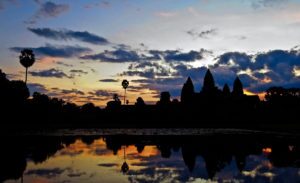
Angkor as seen from space, satellite image. NASA image
____________________________________
The Lost Temples of Angkor
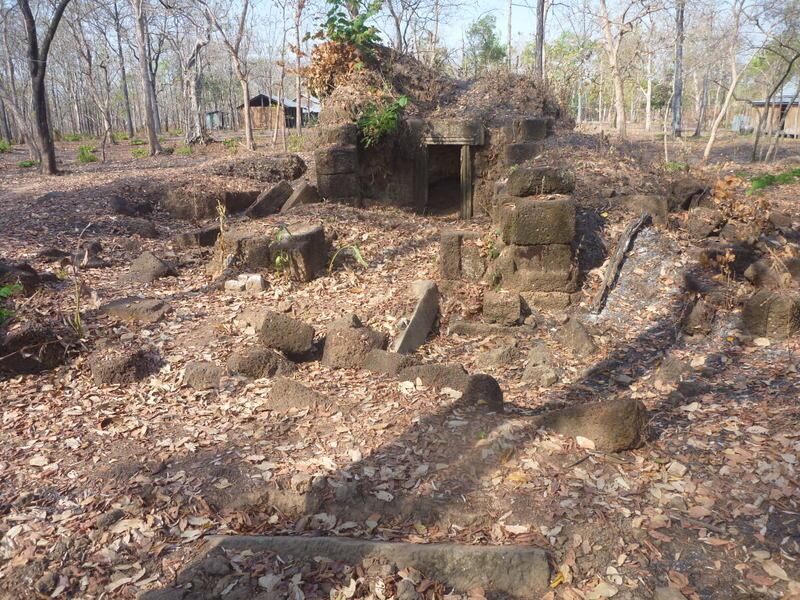
Phnom Penh, Cambodia – By the time they encountered a ten-meter-tall brick wall, trees growing from its top, they had been trudging through the jungle for an hour. It actually wasn’t that far from the village, but there was no straight path. No path at all, in fact. A motorbike couldn’t get through, so they walked. Following their guide, they zigzagged through unfamiliar terrain. They were compelled to look steadfastly down at the ground and step, as best they could, into the footprints of the person before. It was a matter of life or death. They were walking through a minefield, not far from the border between Cambodia and Thailand in the Oddar Meanchay province.
Before they left on this expedition through the forest, Nady Phann, an official from Cambodia’s Ministry of Culture, asked a local villager if there would be any mines. Phann was well aware of this legacy of his country’s war-torn past. “There are many”, the villager said. “We found five or six mines per day when we were planting rice.”
Despite that danger, on that day, in February of 2013, Phann and his team discovered five pre-Angkorian temples. These were temples that had been built before the rise of Angkor, a region of Cambodia that served as the center of the Khmer Empire, the most powerful empire of ancient Southeast Asia. Angkor flourished from approximately the 9th to the 15th centuries, AD, but these temples were made of brick and, according to Phann, they were probably built between the 6th and 8th centuries. Some were almost completely ruined. Others still stood. As he always does when he finds a new temple, he noted the exact location – latitude and longitude – took a few photos, and sketched a plan on a piece of paper. His favorite site, which the locals call ‘The Temple of the Black Water Lake’, consists of three temples in a line close to a nearly dried-up reservoir, with the tallest structure in the middle between the two smaller ones. He also recorded the names of the other sites: the ‘Little Monkey Temple’, the ‘Red Temple’, and strangely, the ‘Economic Development Temple’.
“I don’t know how (the economic development) temple got its name,” Phann admitted. “Maybe it comes from the Khmer Rouge. We have to study the names of the temples — (to find out) if the villagers gave the names or if the name relates to an inscription.”
He was pleased, but not completely blown away by his discovery. That is because more than 150 years after French traveler Henri Mouhot first stumbled upon Angkor Wat (Cambodia’s most popular tourist attraction, which is sometimes described as the world’s largest religious monument) archaeologists working in Cambodia are still discovering ancient temples almost every year.
There are approximately four thousand known Angkorian and pre-Angkorian-era archeological sites in Cambodia, including temples, bridges, reservoirs, and theaters – and new sites are being added to this inventory every year, according to Damian Evans, a University of Sydney archaeologist who studies ancient Cambodian temples. However, most of the newly discovered “temples” do not resemble the grandeur of Angkor Wat. A temple ten meters high is an unusual discovery, he said.
“Over the last 20 years, it’s been a constant process of finding several hundred new temples per year,” he said. “But if they’re finding temples of that size, that’s quite an amazing discovery. Normally we just find piles of bricks, just some rubble on the ground, a few pots here and there. It’s definitely not every day that you find a structure with walls.”
During his career with the Ministry of Culture, Phann added dozens of long-lost ancient temples to the map of Cambodia – probably more than anyone else alive, says Evans.
____________________________________________
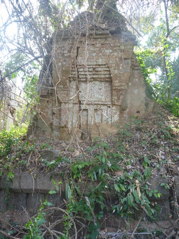
 The Red Temple Photo courtesy Nady Phann
____________________________________
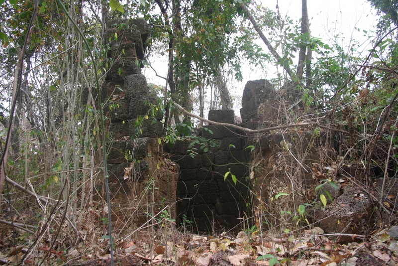
Black Water Lake Temple Photo courtesy Nady Phann
____________________________________
Little Monkey Temple Photo courtesy Nady Phann
___________________________________
According to Yern Hong, the director of the culture department of Oddar Meanchay province, the temples were initially discovered by villagers who went into the forest to gather fruits and hunt for animals. Others say that the temples were found by the Khmer Rouge soldiers, who hid in the forest near the Thai border while fighting the government’s army. But in either case, they didn’t inform authorities in Cambodia’s capital, and that is why the temples had not been documented or studied by archaeologists until now. Even after officials were told about the temples, they couldn’t visit them because of their remote location in the jungle, inaccessible by roads and surrounded by mine fields. Peace had only recently been restored in this sparsely populated area of Cambodia.
While Cambodia’s capital was liberated from the genocidal rule of the communist Khmer Rouge in 1979, fighting continued in some remote corners of the country – particularly near the Thai border – into the 1990s. According to Keo Tann, the police chief of the Traipang Prasat district where the temples were discovered, this area was occupied by the Khmer Rouge until 1998 or 1999.
“Both the Khmer Rouge and the government soldiers laid the mines. The Khmer Rouge reconciled with the government, but the landmines are still in the ground, they didn’t go anywhere. No one can go there because even the soldiers who laid the mines forgot where they put them,” he said.
Mining the areas around ancient temples was a common practice during Cambodia’s civil war because the stone structures could be used as bunkers, according to Heng Ratana, the director general of the Cambodian Mine Action Centre (CMAC), the country’s government de-mining agency.
The remote Oddar Meanchay province is one of the least populated in Cambodia. Christophe Pottier, an archaeologist with Ecole Francaise d’Extreme Orient who works in Cambodia, said that there is approximately one village every 50 kilometers. The temples, hidden by the forest, could not be seen in areal photographs.
In recent years, however, the country’s rapid economic development, the end of the war, and the push to build and pave more roads have led more people to move into previously unoccupied areas. More long-lost temples also began coming into view due to deforestation – in the last ten years, so much of Cambodia’s virgin forests disappeared due to logging that the country, which had appeared mostly green in photographs taken from space, now looks brown, a local newspaper recently reported.
Why so many temples?
There were thousands of stone temples in ancient Angkor, which between the 10th and 13th centuries extended from the border of Myanmar to the west and the Champa Kingdom in Southern Vietnam to the east.
Angkor’s temples, which were built to worship Hindu gods, were erected not only by the king, but also by ordinary people, and were also built to honor deceased ancestors, according to history professor Sombo Manara at the Royal University of Phnom Penh. Over time, it was not uncommon for old temples to be abandoned and new temples to be built somewhere else, leading to an increase in the number of temples over time.
Finding the temples gives historians a better idea about the exact location and extent of the ancient kingdom, and allows them to study how populations moved over time.
“Each of these small temples was a center of a community in the Angkor Empire,” Evans said. “For reasons we don’t clearly understand, the temples were abandoned. Once Angkor collapsed, this whole extended area collapsed at the same time.”
Some theories posit that the empire collapsed after being defeated by a Siamese invasion. According to other versions, climatic changes or drought may have played a role, or the fact that Hinduism was replaced by Buddhism, a more egalitarian religion.
Whatever the reason for Angkor’s demise, Phann and other archaeologists will continue searching for more ancient temples in Cambodia. Nady said he will return to Oddar Meanchey province again in the near future to explore the forest further – as he has heard that there are more temples beyond the minefields.
“We have to do the inventory of all the temples,” he said. “If we know where the temples are, we can inform the companies (that work in the region) that we want to protect these areas”.
* * *
_______________________________
The Names of Angkor’s Lost Temples
Most of the names that are now used to refer to the ancient temples of the Angkor Empire are not original, according to Christophe Pottier, an archaeologist with Ecole Francaise d’Extreme Orient.
“In 98 percent of the cases, the current names are totally unrelated to the ancient names,” he said. “In the Angkor region, we know of temples that changed names three times in a century.”
Moreover, he says, “while some temples change names often, others share the same name. We have maybe 20 temples named ‘Prasat Pum,’ which means ‘the village temple’”.
Pottier explains that when archaeologists find an ancient temple that was previously unknown to them, they usually write down the name that the local people use, but also give the structure a new and unique number.
______________________________________
The Mountain Temple of Angkor
Preah Vihear Province, Cambodia—Dozens of crates with ziplock bags populate the back room of a new museum near an Angkorian temple on the Thailand border. Each bag is carefully labeled in black marker, with the date and location of the artifact contained within. I can’t read Khmer, but I can see that many of the bags are marked with “2013” on them.
Acting Museum Director Seng Kompheak takes out a piece of pottery. “It looks like the face of a monkey because of the big ears,” he says.
From another bag, he removes a small stone object and turns it over—it’s a stamp depicting an image of a crocodile. “We had never seen this. It looks like a prehistoric tool,” he adds.
A large, partly broken jar rests on the table. “It was probably a burial jar,” Kompheak says, “because it has a small hole drilled in the bottom.”
These are some of the objects that will go on display at the Samdech Decho Hun Sen Eco-Global Museum of Preah Vihear, which is expected to open in early 2014. Named after, and funded in part by, Cambodia’s Prime Minister Hun Sen, the museum is dedicated to Cambodia’s second UNESCO World Heritage Site: the mountaintop temple, Prasat Preah Vihear, situated on the border between Thailand and Cambodia. It is an imposing structure, originally built to command a prominent place atop a 525-meter (1,722 ft) cliff in the Dângrêk Mountains during the reign of the Khmer Empire in the 11th-12th centuries C.E. Dedicated to the Hindu deity Shiva, it was known as “Shikareshvara” in Angkorian times.
Thailand and Cambodia have long disputed the ancient temple and the land surrounding it. In 1962, the Hague-based International Court of Justice ruled that the temple belongs to Cambodia—a decision some Thai nationalists did not accept. Fighting between Thai and Cambodian forces sparked up here in 2008 and in 2011, inflicting damage on the eleventh-century temple, which was hit by mortar and artillery shells. The Thais argued that, while the International Court of Justice ruled that the temple belongs to Cambodia, Thailand was not clear as to who owns the land around the ancient monument. To clarify the misunderstanding, the Court issued its final decision in November 2013, giving Cambodia sovereignty over the land around the temple, and ordering Thailand to withdraw its military from the area.
Located 500 km from Cambodia’s capital, the Preah Vihear Temple has long been inaccessible. Partly because of its remote location, Preah Vihear was among the last strongholds of the Khmer Rouge—civil war ended here only in 1998, and the area is still heavily mined. French colonial archaeologists couldn’t learn much about the site because of the land dispute with Thailand, according to Christiane Garnero Morena, a UNESCO expert who worked on the museum. It’s now impossible to get to the temple from the Thai side. The border has been closed since 2008, and visitors with Thai passports aren’t allowed to approach the temple.
__________________________________________
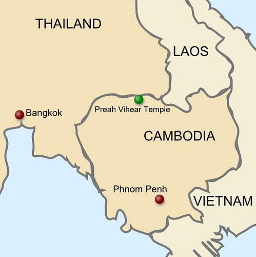
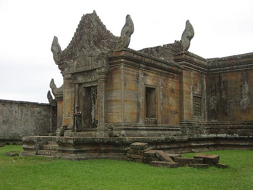
The Preah Vihear Temple straddles the border between Thailand and Cambodia
_________________________________________
________________________________
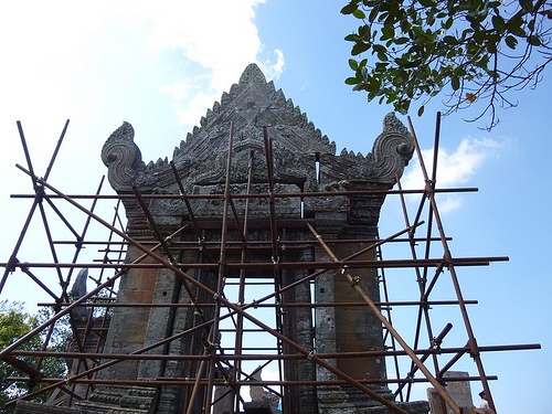
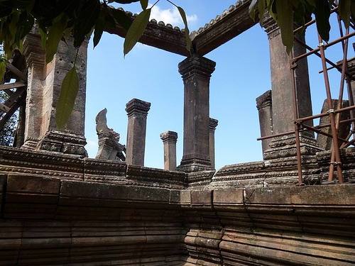
Above and below: Today, scaffolding is a visible reminder that Cambodian authorities are focusing efforts to manage and develop the site. Photo by Julie Masis
_________________________________________
___________________________________________
Perhaps because Preah Vihear Province has remained inaccessible to archaeologists, there’s a wealth of undiscovered history here. In the last five years, while digging trenches and building barricades, Cambodian soldiers came across dozens of Angkorian artifacts. The conscious effort on the part of the Cambodian government to develop the area for tourism has also helped; historic items were unearthed during road construction, or were returned to officials after villagers heard that a museum was being built.
“More than 500 pieces were found in the last few years,” said Pheng Sanoeun, director of the Department of Monuments and Archaeology at Cambodia’s National Authority for Preah Vihear. “We don’t count every single artifact. We are not interested in the number of pieces. We are interested in the pieces that give us new information.”
“The items were most likely left behind by the people who built the temple approximately a thousand years ago,” he added. Construction of the Preah Vihear Temple began in the ninth century, and lasted more than 200 years.
According to Philippe Delanghe, the culture specialist at UNESCO’s office in Phnom Penh, some of these newly discovered ceramics are considered extremely valuable or unique. Angkorian specialists are particularly puzzled by a small clay jar with holes in the lid. It may have been used for a medicinal purpose, as the holes would let vapor out.
“I have never seen a stamp with a picture of a crocodile on the bottom or a lid with many tiny holes in it,” said archaeologist Ea Darith, who wrote his PhD thesis on Angkorian ceramics.
Getting There
After almost four years of working as a journalist in Cambodia, Preah Vihear was the last important tourist attraction I hadn’t visited.
I was discouraged by Google Maps, according to which the easiest way to reach the temple is from Thailand, and by the Lonely Planet Cambodia travel guide, which notes that “the poor state of the roads, especially in the wet season, turns any trip up to Prasat Preah Vihear into something of a trek.” The guide also states that the accommodations in Sra Em, the closest village to the temple, are “rudimentary,” and “both uncomfortable and filthy.”
It happened, however, that this information was outdated. A new road has been built recently, shortening the trip between Siem Reap (where Angkor Wat is located) and Preah Vihear Temple to only three or four hours. Moreover, at least three new hotels—with 24-hour electricity and air conditioning—have opened in Sra Em, which is about 30 minutes from the temple.
Despite the improvements, not many tourists make the trip—and the journey along the almost deserted National Highway 67 to Preah Vihear Temple is still an adventure.
About halfway between Siem Reap and Preah Vihear lies the dusty town of Anlong Veng, the former Khmer Rouge stronghold that gives the impression that war ended only yesterday. Stray dogs wander along the town’s only street. Once darkness falls at 6 pm, people use flashlights to see where they’re going. There are no restaurants serving Western food, hotel workers don’t speak English, and children stare at foreigners as if they were exotic animals at a zoo.
We spent the night in Anglong Veng, and the next day took a “taxi” to Sra Em. It was not a pleasant ride: in typical Cambodian fashion, there were two passengers in the driver’s seat, five people in the back, and one in the trunk. The driver, sporting very long, curvy fingernails, answered his phone constantly, yet somehow managed to narrowly avoid collisions with cows and oncoming trucks. At one point we came to a broken bridge—one side of it was on the same level as the road, but the other came down at an almost 45 degree angle. Not stopping to inspect the structure, overloaded vehicles—including ours—simply drove across, assuming it would hold. All we could do was close our eyes and pray.
The Museum
The museum of Preah Vihear wasn’t officially open to the public when I visited at the end of October 2013—but the director greeted me at the entrance with his entire entourage and spent about two hours showing me around.
A pair of recently unearthed pieces of sandstone from Preah Vihear Temple guard the entrance—the ancient sculptor may have intended to turn them into lions, Kompheak said, although it’s hard to tell now.
A map on the wall illustrates the dimensions of the Khmer Empire, which once stretched from southern Vietnam to Thailand, Myanmar and parts of Malaysia. Another showcases the locations of Angkorian temples and how they were connected by ancient roads. One such road led from Angkor Wat to Preah Vihear—which, in Angkorian times, was called Shikareshvara —and from there to Wat Phu, in Laos. Along these royal roads, the kings of Angkor built the so-called “houses of fire” every 15 km—places where people stopped to pray and rest after a half-day’s journey, according to Kompheak. The rulers of Angkor also built 102 “houses for the sick”—hospitals—along these routes.
When this museum opens, visitors will first see the statues of two life-sized kneeling attendants, which were returned to Cambodia in the summer of 2013 from the Metropolitan Museum in New York, after museum authorities learned that the statues had been looted. More recently, a third ancient sculpture depicting Duryodhana, a Khmer warrior, will be displayed here as well — An American court determined in December that the statue, worth more than $2 million, should be returned. All three statues originally came from the Koh Ker temple complex in Preah Vihear Province.The statues show deities in motion, and are among the best that the Khmer empire produced, according to experts.
“Hopefully, more sculptures will come back to the country in the future,” Delanghe said.
To prevent further looting, on their own, authorities proactively removed several important works from the Preah Vihear Temple. One of these is a walking lion, which was brought to the museum from Preah Vihear Temple three months ago. “It’s an unusual lion,” Kompheak says. “In Khmer art lions are almost always standing, while this one is in motion.” Another is a sculpture of the Hindu god Vishnu, who holds an object in each of his four arms, symbolizing wind, fire, earth, and water. Finally, Kompheak shows me a door lintel from the temple, with images of cows and buffalos. Behind the sculpture, visitors can see cut marks. According to Kompheak, they were made by looters who tried to carry away the stone but couldn’t because it was too heavy.
The second museum building exhibits huge photographs of some animal species unique to Preah Vihear Province—including the critically endangered giant ibis, Cambodia’s national bird, and the kouprey, the country’s national mammal—a wild ox that’s on the verge of extinction from hunting and diseases introduced by domesticated cattle. There are also pictures of a peacock with a beautiful azure tail, a red-headed vulture, several species of frogs, and a southern serow, which Kompheak says is a goat-like herbivorous animal whose skin and bone powder are mixed with coconut juice or rice wine and used in traditional Cambodian medicine.
Around the museum, workers planted local trees, and labeled each one. The sap of one tree can be used to waterproof the bottom of boats and baskets, Kompheak explains. Another local variety was used to make wooden statues in the post-Angkorian period.
The idea behind the exhibits on flora and fauna is to create a link between Angkorian history and Cambodia’s natural environment—which also links the past to the present, according to UNESCO experts.
“Many museums have beautiful artifacts, but they are not connected to the location that they came from,” Garnero Morena said. “This museum is completely different from other Cambodian museums because there is no other museum in Cambodia that links ancient history to the present day.”
________________________________________
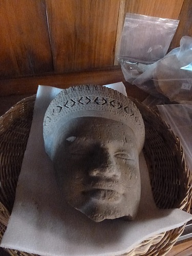
Above and below: Two recent finds awaiting display in the new museum. Photos by Julie Masis
______________________________________________________
Linking the Living with the Past
The Eco-Global Museum of Preah Vihear is also the first in Cambodia to have an exhibit on an ethnic minority group.
The display focuses on the Kuay, who have lived in Preah Vihear Province since the days of Angkor, and were intimately connected to the royal court. Because of their skills in iron smelting and domesticating wild elephants, the Kuay supplied the kings of Angkor with weapons and war elephants, according to Gérard Diffloth, another UNESCO expert who helped prepare the exhibit.
“The Kuay used to be iron smelters, extracting the ore from nearby hills and smelting it at very high temperatures to obtain iron ingots. This is high technology, using only traditional tools: bamboo, bellows made from buffalo-hides, and special charcoal,” Diffloth wrote in an email. “The technique is ancient, and was borrowed from India in ancient times. The Kuay had a monopoly on this industry, and the Khmer never took part in it.”
The museum places the Kuay villagers’ everyday items on display: mats and water containers from palm leaves, bamboo benches, and the monks’ palm-leaf manuscripts. These manuscripts, created using metal, string, and charcoal, were probably first used in the thirteenth century when Buddhism arrived, Kompheak said. There is also a display of big baskets that the present-day Kuay people wear on their heads during a rain-prayer ceremony that marks their New Year celebrations. The last item that caught my attention was a modern-looking hand-made toy: a cart made from a cut-up flip-flop (sandal) and a discarded plastic bottle.
“It’s very important to link the people who live here today with their history,” Garnero Morena said.
An Uneasy Presence
I couldn’t help but notice that one important piece of modern history was missing from the museum: the conflict with Thailand, and the dispute over who owns this ancient Angkorian site. While all the information in the museum is provided in three languages: English, French (Cambodia is a former French colony), and Khmer—there is no Thai translation.
“We don’t want to remind (visitors) about the war. It’s not good,” Kompheak said.
But, while war is never mentioned in the museum, it continues to affect the ancient temple and the lives of the people around it. In the past five years, due to fighting near the border, authorities relocated the residents of three communities near the Preah Vihear Temple—more than 1,200 families in all. This allowed government officials to expand the protection zone around the temple—now 10 by 20 km. One village, called Kor Muy, had actually been built on an ancient reservoir. Authorities have since refilled the reservoir with water and hope to conduct excavations to determine how big the ancient village was, and how many people lived there.
As we raced along the new, completely deserted road on our way from the museum to the temple, my eyes unconsciously scanned the landscape for ditches to roll into in case shooting broke out. We passed a village of identical houses with bright roofs: homes for the soldiers’ wives, we were told. At one point, we saw a tank coming toward us. Even our motorbike driver was a soldier. Since the village of Sra Em seemed to be cut off from the rest of the world, we questioned him about news at the border.
“Was it safe to visit the temple today?” we asked.
He said he didn’t know.
Tickets to the temple are free but required: foreign visitors must show their passports. Since there are no such regulations at any other Angkorian site in Cambodia, I could only imagine that the ticket was a safety measure: if something went wrong, authorities would know who was injured or killed. After the ticket booth, the ascent to the temple, which towers 625 m above sea level, became so steep that it could only be managed by the use of motorbikes with good brakes and four-wheel drive trucks.
On the top, I snapped photos of the out-of-breath Cambodian soldiers in camouflage uniforms — they had just hiked up the mountain with live turkeys in their arms. It appeared they were getting ready for lunch.
The temple itself surprised me. While I had seen it countless times on Cambodia’s 2,000 riel banknote—the equivalent of about 50 cents—it turned out that it was not one structure, but many pavilions stretched over 800 m, connected by steep stairs and a stone-paved road. The climb, under the scorching sun in the middle of the afternoon, made me stop several times to catch my breath.
___________________________________________________
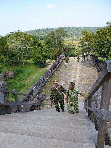
Cambodian soldiers are a frequent presence at the temple complex remains. Photo by Julie Masis
________________________
Unanswered Questions
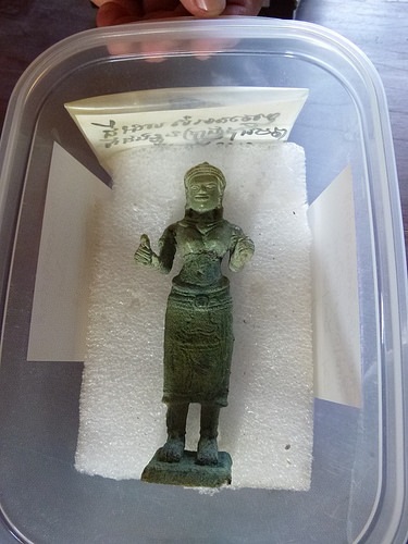
Much remains to be uncovered and learned about the ancient site. Among other items recently found in the area—soon to be on display at the new museum—are a small bronze figurine of a female deity that was unearthed during the construction of a military base, a tiny bottle that may have been used to hold perfume—returned from the military during a training seminar on ceramics conservation—an urn that held someone’s ashes, and a jar that was used as an oil lamp. The oil lamp is also an unusual find: according to Sanoeun, very few Angkorian oil lamps had been found—and generally only near royal palaces—so finding one at Preah Vihear indicates that the area was important during the Angkorian period.
Archaeologists also discovered thirteenth century Chinese ceramics, which suggests that the people who lived in Preah Vihear had trade ties with China. The researchers’ goal is to gain more knowledge, not only about the temple, but about the daily lives of the people from the communities that surrounded it hundreds of years ago.
“This is very important for us because we know that Preah Vihear was a very important site during the Angkorian period, but we don’t know too much (about it) because we don’t have many researchers working on that,” Sanoeun said.
One intriguing unanswered question relates to its location. Australian archaeologist Damian Evans, a Postdoctoral Fellow with the University of Sydney who has led extensive research related to Angkor, is puzzled about how it was connected to the ancient Khmer capital. According to research conducted by his archaeologist colleague Mitch Hendrickson, who has examined artificial earth embankments and ancient bridges, the royal Angkorian highway led from Angkor to Wat Phu in Laos – but passed 40 kilometers away from the Preah Vihear temple. Angkorians also used rivers for transportation, but there are no rivers of suitable size near the Temple, according to Evans.
So how was the Preah Vihear Temple connected to Angkor Wat?
The answer might be found with technology.
To recreate maps of Angkorian cities, Evans and his team used LiDAR equipment, a technology that employed laser beams that bounced back to them, much like radar, to map small variations in altitude at Angkor, including Phnom Kulen, another old Khmer capital. Since Angkorian roads and streets were built higher than the surrounding rice fields to prevent flooding during the rainy season, they were able to map the ancient city blocks. To conduct this study, they flew back and forth over the ancient sites in a helicopter with their laser equipment.
But undertaking a similar study in Preah Vihear province, although very interesting, may not be possible in the current political climate. “We could definitely locate the existence of minor roads in the area using LiDAR, but that is not going to happen any time soon,“ says Evans. “To fly an aircraft low and slow over the disputed area would require a tremendous amount of planning and international cooperation at the very highest levels on both sides of the border – and I don’t think it’s feasible just for the purposes of archaeology, if at all in the current political climate.”
For now, it is a matter of waiting. In the meantime, Cambodian heritage authorities will continue to do what they can to raise the profile of the mountaintop temple as yet another gem in their cultural landscape.
_________________________________
Living in the Shadow of Angkor
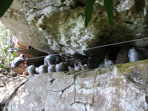
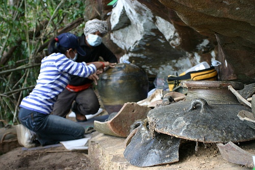
Lying beside the Phipot River about four hours drive from the Cambodian capital of Phnom Penh, the quiet community of Chi Phat goes about life much like many other villages and communities in the Cambodian countryside. These people are mostly farmers, growing rice, bananas and other crops, and fishermen. But a large number of village families also participate in the Chi Phat Community-Based Ecotourism (CBET) project, established about ten years ago with the help of a conservation organization. The ecotourism business offers a range of activities for those tourists who want the more unconventional experience of off-the-beaten-path activity and trekking—like morning bird-watching trips on the river, crab hunting at night, tree-planting, and trekking in the jungle. For those with special interests, such as archaeologists interested in the human past and things ancient, Chi Phat offers a special attraction—a chance to view the remains of a unique, ancient, mortuary ritual of a people still shrouded in mystery.
To see this, it often takes a journey on the back of a motorcycle along a trail so narrow that overhanging vegetation will scratch unprotected legs. The trail is at times so muddy that the rider must dismount to walk through leech-infested terrain, across fast-moving streams and slippery rocks, through clouds of butterflies, and near unsuspecting snakes. The trekker finally reaches a small clearing, to climb the rest of the way up a mountain to a wooden ladder. Here one encounters three high rock ledges. To explore the largest of them requires carefully crawling on hands and knees along a rock surface with a low ceiling above, inches away from the edge, a fall from which would surely mean an unsupported climber’s injury, if not death. Along the rock ledge surface are chipped stoneware jars containing bones, and what appear to be skillfully but simply crafted small wooden coffins with wooden lids. The bones within the jars are human. It is an ancient burial site.
Archaeologists have interpreted it as a secondary burial ritual mortuary site, one among 10 similar known sites distributed over 100 kilometers of the eastern ranges of Cambodia’s Cardamom Mountains jungle environment. Secondary burials have been practiced by a variety of cultures throughout history. They are often described as rites in which the bones of the deceased are placed in urns, bone boxes, or other vessels after the flesh has been stripped from the bones by natural decomposition. This particular secondary burial site, known as Phnom Pel, is the closest one to Chi Phat, and it, along with several other such sites, have been the objects of intensive study by Dr. Nancy Beavan and a team of associates. Beavan is an expert in radiocarbon dating, based at the University of Otago in New Zealand. She has examined and dated bones from a multitude of burial sites across the globe, but there was something unique and compelling about the Phnom Pel finds and those of the other nine sites. Beavan has made it her mission to find answers.
__________________________________________________________________________________________
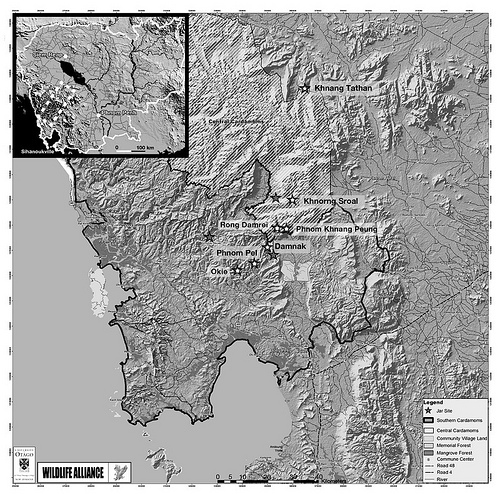
Map of Cambodia and the Cardamom Mountains region. Stars mark all 10 sites that have been geo-located during the project work. The distance between the southernmost and northernmost sites is about 72 km. Map from Beavan, et al., 2012
____________________________________
“I got a call from the documentary film-makers for National Geographic’s “Riddles of the Dead”[in 2003],” said Beavan, “who asked me if I could date a bone in 3 weeks. After I started to prepare the bone, I became rather curious because it looked so fresh. I got back in touch with them and they told me it was from Cambodia and from a burial site.”* The dating of the bone placed it during the time of the demise of the Khmer Empire in the mid-fifteenth century CE. That was the civilization that built the iconic temple structures of Angkor.
“I became absolutely fascinated”, she said.*
That fascination drove Beavan to investigate the original context of the bone, a journey that eventually led to a full-scale study now financed under a $720,000 grant from the Royal Society of New Zealand Marsden Fund.
It hasn’t been an easy journey.
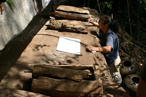
The site where the bone was found is known as Khnorng Sroal, a Cardamom Mountains site located high on a south-facing natural rock ledge. And like Phnom Pel and the other sites, access for extended study requires some extraordinary measures. Motorcycles must be used to negotiate narrow trails, rivers must be crossed, long hikes are required on rugged terrain. And then there is the climbing, as the sites are located on elevated rock ledges. “Instead of going to these places and collecting everything to take back to a comfy lab to work on,” says Beavan, “we live in the jungle for weeks at a time eating dried fish and dried sausages and rice, using this time to do all of our data collection in the field, and taking only tiny samples for scientific analysis, so that we can conserve and protect the sites in their original state.” At another site known as Phnom Khang Peung, 600 meters above seal level and deep in the jungle, they had to use a helicopter to bring in enough water and provisions, including people, to stay for two weeks of field work. “And helicopters are not cheap,” Beavan exclaims, “so that straightforward solution has only been used once!”
Two central questions have underpinned Beavan’s entire effort: Who were these people? And why did they “bury” their dead this way?
Out From Oblivion
For obvious reasons, much of the archaeology and research on ancient Cambodia has focused on the more visible and spectacular sites of the Khmer Empire, arguably Southeast Asia’s greatest ancient civilization, whose temple builders dotted the landscape with wonders like Angkor Wat and Angkor Thom. Flourishing from the ninth to fifteenth centuries CE, it dominated the region economically, culturally, and politically. Indeed, chronological and historical referencing in both popular literature and academic studies in the broader examination of Southeast Asia’s past have usually anchored around ‘before’, ‘during’ or ‘after’ Angkor.
But there is something apart, unique and tantalizingly mysterious about these Cardamom Mountains rock ledge burials when compared to the better-known discoveries associated with Angkor. Beavan thinks they could tell a story of a forgotten highland people with a unique culture living on the margins of the Angkorian world during its waning days in the fifteenth century, and then long after it’s fall. She also suggests that, though their time overlapped with that of the end of Angkor, the mountain culture that created this funeral ritual was separate and distinct from Angkor.
The first clue to this evolving story has to do with location. “The rugged terrain and isolation of the region has given it notoriety over the centuries as a place of refuge. The mountains have also been home to ethnic minorities who notably lived apart from the Khmer culture of the lowlands and were seen as “savages” and taken as slaves in Angkorian times,” writes Beavan and colleagues in an international publication in 2012. **
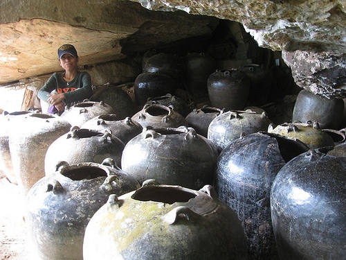
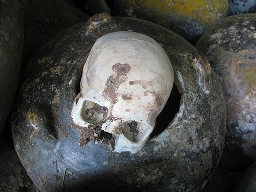
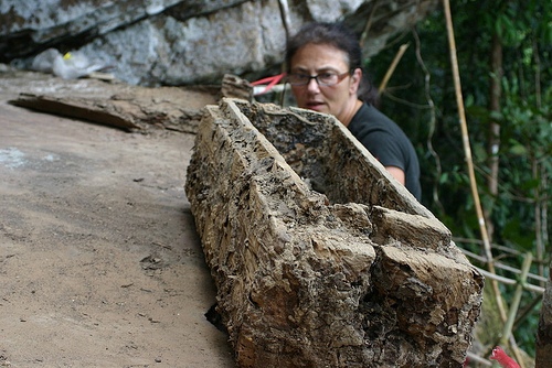
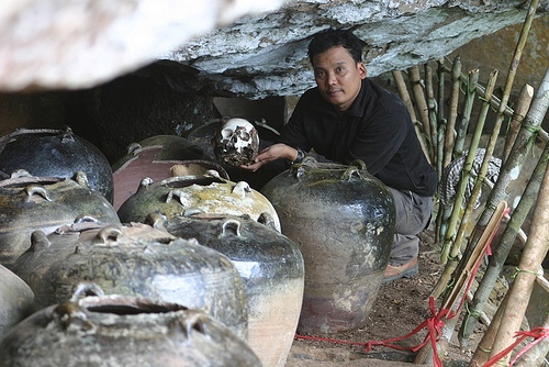
The second clue relates to the nature and unique combination of characteristics of the finds. Those sites, which Beavan has radiocarbon dated to between CE 1395 to 1650 using wood, tooth enamel and human bone samples from four sites, feature ritual use of 53 cm high stoneware storage jars containing human bones, and small coffins (averaging only about 1 meter in length), each much too small to accommodate a flesh and blood adult. The jars and coffins were placed together high on rock ledges or overhangs. The 50-53-cm-high stoneware jars used for the burials are known as Maenam Noi jars, made at the Maenam Noi kilns in the Singburi province along the Chao Phraya River in Thailand. These jars were in production from about the fourteenth to possibly the sixteenth centuries CE. The kilns are hundreds of miles distant from the region of the Cardamom sites. Says Beavan:
“There are at least 75 of these large storage jars among the 10 sites that we have located, and let me tell you, getting these things up into their mountain burial sites must have been a mission and a half. But they did, and they were very particular, too: only a certain type of storage jar, and then after having procured them and hauled them by some still unknown means into their mountain homelands, they used them simply to contain the bones of their dead, filling the jars with one or more skeletons.”
_____________________________________________
The secondary burial jars and coffins were placed high on rock ledges in the Cardamom Mountains. Photo Credit Tep Sokha
______________________________________

Dr. Nancy Beavan sitting among the artifacts on the Phnom Khnang Peung site ledge. Photo Credit Ouk Sokha
___________________________________
A perspective view of the jars on a site rock ledge. Sitting in the background is Danni Eam, a member of the field team. Photo Credit Ouk Sokha
____________________________________
Mr. Gan, a long-time member of the team and a member of the Chong ethnic minority, sieves sediments on the jar ledge for artifacts. Photo Credit Ouk Sokha
____________________________________
And there is much more. Writes Beavan in the 2012 report:
“All of the burial jars appear to have been prepared by breaking away the rim to facilitate the emplacement of larger skeletal material such as entire skulls. A hole was drilled through the bottom of each jar, perhaps to ritually “kill” the vessel. The log coffins in the Phnom Pel, Damnak Samdech, and Khang Tathan sites are made of an as yet unidentified tree species, which is extremely dense and has a fine annual growth structure. The coffins vary in overall length between 90 to 178 cm, but their design is generally similar in that whole logs are cut into sections, the centers are carved out in squared corners, and each is topped by a lid, but there is no additional carving or decoration to the exterior. The exception to this, at one of the oldest sites, Khnang Tathan, is a single coffin of 210 cm, which has deep chevron carving on the ends of the coffin lid.”**
In addition, the jars were found to contain green, yellow and blue glass beads, and simple bronze rings. The assemblages in all 10 sites also contained additional tradeware jars, bowls, and dishes, possibly used, according to the archaeological interpretation, for food offerings. Curiously, at every site Beavan and her team always found at least one 45-cm-high ceramic Angkorian jar, made at the Buriram kilns in an area bordering the western boundaries of present-day Cambodia and Thailand. In the twelfth-thirteenth centuries CE the Buriram kilns were part of the Angkorian kingdom. The Angkorian jars are significantly earlier than the more numerous Maenam Noi jars. “The Angkorian jars sort of stick out like a sore thumb,” Beavan told the Phnom Penh Post recently. “Why, if you are collecting Maenam Noi with such a passion, do you pop in one Angkorian jar? What does that mean?” Though Beavan suggests that these people were not associated with the lowland Angkorians, had there been any sort of an Angkorian connection?
Perhaps. Yet most of the elements belie a cultural identity with Angkor. Write Beavan and her colleagues in their 2012 article:
“The ritual practices in the mountains are distinctive compared with what is known of lowland mortuary practices in the pre-Angkorian and Angkorian periods. What is especially remarkable about the Cardamom sites, and suggests much about their inter-relationship and the cultural similitude of those who created them, is the overall uniformity of the material aspects of the ritual for the dead. This uniformity includes such items as the small nautical tradeware bowls and plates that were possibly used for food offerings, the use of coffins in 3 of the 4 sites presented here, and the Maenam Noi jars used for the burials in all but the Khnang Tathan site.”**
__________________________________________________________________________________________
Above and below: The ancients deposited the defleshed bones in modified Maenam Noi jars. Photo Credit Ouk Sokha
______________________________________
Dr. Nancy Beavan views and examines a coffin on a ledge. Credit Ouk Sokha
______________________________________
Nancy with three types of coffins at a site. Ouk Sokha
____________________________________
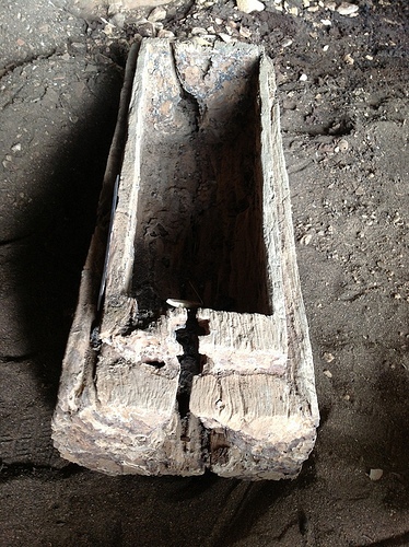
The body of a coffin, which also has a tight fitting lid (not shown). Note the detail in the simple carving of the rim designed to receive the equally well carved lid. They are simple designs, with no outer decoration, but the craftsmanship of the people who made them is evident in the fine edges and the fit of the lids. Photo Credit Ouk Sokha
_____________________________________
To be sure, the general use of jars for secondary burials is not unique to these sites. The practice has been found at a number of ancient sites throughout Southeast Asia, including locations in Cambodia, Indonesia, Thailand, Laos, Vietnam, Okinawa, Borneo, Mindanao, and the Phillipines, to name a few. But those “jar burial” practices consist of the literal burial of the jar in the earth. The Cardamom Mountain ritual is among the few anywhere with jars set out upon the ground or in rock niches. The ceramic jars from Thailand’s Maenam Noi kilns used by the ancient tribes of the Cardamom Mountains, according to Louise Cort, curator for ceramics at the Freer and Sackler museums of Asian art in Washington, DC., were the “all purpose containers at a time when there weren’t other alternatives” – they were used to store everything from rice and indigo to sulfur for gunpowder and even textiles (so that insects couldn’t get to them). The jars were also used as containers for commercial goods that were shipped and traded from Siam throughout Asia, reaching as far as Japan. “They are very commonplace jars,” Cort said. “But what’s interesting is how these jars were moved and acquired and then taken up into the mountains.”
Some light was shed on this in 2006 near Cambodia’s Koh S’dech Island off the coast of Koh Kong Province in the southwestern Cardamom Mountains, when fishermen began pulling these same jars out of the sea. Further investigations by Cambodia’s Ministry of Culture showed that they had actually uncovered a medieval shipwreck, yielding 900 pieces of pottery in two recovery dives. Most of the cargo’s pottery consisted of Maenam Noi storage jars, exactly like the Cardamon bone burial jars, as well as examples of other types of ceramic ware of the period. Either it was a ship carrying only empty jars, or it was transporting another commodity inside the jars, Cort says. The discovery has led the researchers to suggest that the highland people identified with the jar and coffin burial sites may have exchanged forest products, such as wood, cardamom, and elephant tusks, for the jars and then brought them inland in river boats. Beavan cites the historical record of Zhou Daguan, a Chinese emissary who visited Angkor in the thirteenth century, who commented on how “mountain ethnic groups collected and sold exotic and desirable forest products such as resin, elephant tusks, and cardamom; these products would have been sought by supracultural traders.”** The shipwreck’s discovery underscored another distinction between these highland people and the people of Angkor — they used different trade routes. If the trade theory is correct, “the people of the Cardamom Mountains got their jars through a maritime trade connection in the Gulf of Thailand that the Angkorian people didn’t have,” according to Beavan. “The Angkorians used mainly overland trade routes, and possibly river systems. The Angkorians also created their own ceramics; the people of the Cardamoms appear not to have had any such ceramic tradition, as only tradeware has ever been found among the sites.”
Clues from the Living
Often the stories of living descendants or people who later settled the area of an archaeological site can provide some hints or insights that archaeologists can use to help interpret the material finds in the field. Beavan and her team have made a point of ensuring that what ethnologists and the current local inhabitants have said about the jars and their past play a role in helping to understand who these highland people were, and why they practiced this unique mortuary ritual and burial practice.
French ethnographers Marie Martin and Jean Ellul conducted studies of the current Cardamom highland inhabitants decades ago, and recorded stories from the people there of “bones in caves”, bones they thought belonged to the “people of the court” of Longvek, (a trading port on the Tonle river just north of present-day Phnom Penh) who had fled a Thai invasion in 1593. The site to which they referred was located in the Cardamom range flanking Kampong Speau province. But it was further investigated by Ellul and Roland Mourer, a French archaeologist, who concluded that associated remains, consisting of simple glass beads and metal rings, likely did not represent those of a high-status group or royalty and thus these people would not have been good candidates for the “people of the court”.
“For some reason they did not comment on the ceramics,” says Beavan, “but perhaps they did not realize they were looking at a very uncommon ceramics collection! And then, the researchers simply walked away from this quite unusual burial site, and the story of their single visit is recorded only by Marie Martin writing about her pre-1975 research in the Cardamom Mountains.”
Other oral traditions mention a “Chong Empire” that predated that of the Khmer. Its capital was said to be located near the town of Chanthaburi in Thailand. One legend has it that a people known as the Pear/Por of Kulen, north of Angkor, emigrated to the Cardamoms and discovered a cardamom spice called kravanh, a substance used in divine offerings during the eleventh century. Among thje legends, the Samre people of the Pursat Province also mention a Chong Empire that preceded the Khmer.
Were the ‘people of the jars’ a remnant of the Chong Empire, or somehow connected to them? There is no evidence to suggest this. And other than the single twelfth-thirteenth century Angkorian jar from the Buriram kilns that archaeologists have found at each of the Cardamom burial sites, there is nothing to suggest any real connection to Angkor or its people.
Beyond investigating known sites, archaeologists are also looking for new ones — the Cardamoms stretch for 20,000 square kilometers, and large areas still haven’t been surveyed. To find the sites and learn more about them, they are collecting stories about the jars from villagers. Finding people whose families are originally from the Cardamoms is not easy because during the Khmer Rouge period villages were forcefully relocated to different parts of the country — so much so that in Chi Phat probably as few as 10 percent of the inhabitants have family who lived in the area before Pol Pot’s regime.
Still, some locals maintain a connection to the sites.
On several visits to the mountain ledges, researchers came across candle wax and plastic bags. Once, scientists even encountered a group of 20 villagers who made a three-day trek on foot to offer food and incense to the bones. It is not clear whether these people have an ancestral connection to the site. Regardless, researchers are interested in interviewing the locals.
“We try to collect old stories, even old myths because sometimes in a myth there is a grain of memory,” says Beavan.
But the mystery remains.
A Race Against Time
Whether or not Beavan and her team ever find all of the answers they are looking for, one thing is certain — their time is running out. Like so many other verdant rainforest and mountain habitats and regions across the globe, the natural riches of the Cardamom Mountains region are in danger of disappearing at an ever-accelerating pace. Modern development has already taken its toll. Bulldozing and deforestation have left red-earth scars where once stood relatively untouched rainforest. Along with the wildlife and vegetation, any human cultural remains, like those of the jar and coffin ritual burial sites, will go with them, if not protected.
“There is a lot of illegal looting still going on,” Beavan says, “and economic land concessions, which turn the foothills into sugarcane and rubber plantations; hydroelectric schemes which flood valleys; black market trade in precious wood species; poaching of some of the world’s most endangered species; elephants and other wildlife being squeezed out of their natural ranges.”***
Beavan believes she has about 5 years to run with her project before it is too late, unless something is done to preserve the known sites as well as any future sites they may discover. She is now working with the Cambodian Ministry of Culture and Fine Arts to develop a heritage protection plan, hoping to buy more time.
And plenty of time is what it takes if archaeologists expect to get more than a few scraps and clues about who these people were and how they related to the larger context of Cambodian history and culture during the final years and aftermath of the Khmer Empire. Thus, like any project of an archaeological nature, the work is characteristically slow, but the mystery is compelling.
“Despite the work that has now spanned some ten years,” says Beavan, “we still do not know exactly who these people were, or where their burial practice came from. Did they make it up themselves? Did they get the idea from vaguely similar practices of other mountain people in Vietnam, Laos and Thailand and if so, how did that happen?”
So Beavan and her colleagues liken their work to piecing together a giant jigsaw puzzle, but without the benefit of the box lid that illustrates the complete picture. And most of the pieces may never be found.
In the end, they can only hope that enough of the picture will eventually materialize to tell a story of an enigmatic highland people who, long forgotten in the shadow of Angkor, lived their lives on the margin.
________________________________________
* Nancy Beavan, “Burial Practices in the Cardamom Mountains,” interviewed by Kathryn Ryan, Nine to Noon, Radio New Zealand, July 20, 2012.
** Nancy Beavan, et al., “Radiocarbon Dates from Jar and Coffin Burials of the Cardamom Mountains Reveal a Unique Mortuary Ritual in Cambodia’s Late-to-Post-Angkor Period (15th-17th Centuries AD)”; Radiocarbon, 54: 1-22, 2012.
*** Nancy Beavan, “Burial Practices in the Cardamom Mountains,” interviewed by Kathryn Ryan, Nine to Noon, Radio New Zealand, July 20, 2012. Also includes statements to Popular Archaeology.
_________________________________________
A Lab in the Jungle
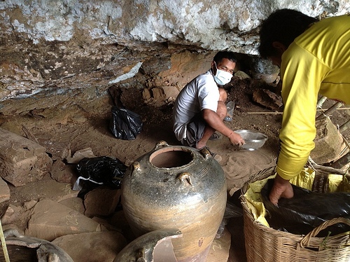
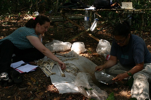
Much of the work of Beavan’s team is done in the field at the sites where the finds exist. There, the artifacts are recorded, mapped, measured, collected, sorted and examined. Thus, with the exception of sampling for radiocarbon dating where special equipment and facilities are required, they eschew a comfortable lab to study and work on all of the artifacts on site. “We live in the jungle for weeks at a time eating dried fish and dried sausages and rice, using the field time to do all of our data collection in the field, and taking only tiny samples for scientific analysis, so that we can conserve and protect the sites in their original state,” Beavan related to Popular Archaeology. Conservation takes place concurrent with the scientific work they perform at the site. For example, fragments of some of the ceramic ware that lay on the surface of the rock ledges, such as that of the Maenam Noir jars, were carefully pieced together onsite, an activity that in archaeology is normally done in museum or university conservation laboratories.
___________________________________
Above, Tep Sokha and Danni Eam, responsible for the ceramic conservation work of the research team, reconstruct one jar that was broken into more than 160 pieces. All of this conservation work takes place in the middle of the jungle. Sokha has reconstructed dozens of burial jars and bowls, piecing them together like a puzzle. He doesn’t remove anything from the rock ledge – doing so would mean destroying the jar cemetery – so he places the reconstructed jars back on the ledge in the position where the fragments were found. He then photographs them to record their appearance. Says Beavan, “Mr. Tep is an extraordinary ceramic conservator. He can take a large jar broken into more than a hundred pieces and put it back together in the middle of the jungle on cliff edges. And one of his findings is that in those ancient times, people were also trying to mend their broken jars. Mr. Tep found two jars where broken pieces had been fixed anciently using natural tree resins.” Photo Credit Ouk Sokha
Above, Tep Sokha, the chief ceramics conservator, with a skull. Photo Credit Ouk Sokha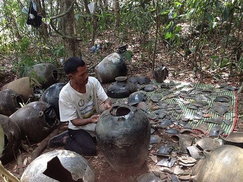
Above, Mr. Gan, a member of the field research team, piecing together broken jars. Photo Credit Nancy Beavan
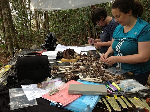
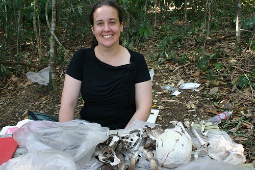
Above, Dr. Sian Halcrow (right), Chief Bioarchaeologist for the project, and Stacey Ward at work at their bone analysis station in the midst of the jungle.
__________________________________
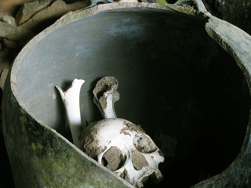
Dr. Halcrow’s research on the bones suggests that the people who were buried in the jars did not die a violent death—their bones give no indication of that. The skeletal remains range in age from preterm infants and babies to older adults, including a skull that belonged to a woman who lived long enough to lose all her teeth in old age.
One of her most interesting discoveries relates to the teeth of the dead: many of the skulls have had the two lateral incisors—the teeth on the left and right of the two central teeth—removed. She believes that these teeth were pulled out deliberately—either as a sign of tribal affiliation or for beautification. According to Halcrow, pulling out teeth or changing how they look—by filing to give them a different shape or by removing teeth in a certain pattern — is a ritual that was last shown to have been practiced by lowland peoples in the Cambodian region around 200 CE. There is no mention of this practice in Angkor, however.
Halcrow also thinks that members of this tribe probably consumed significant quantities of rice, and that they did not eat much fibrous food, as the teeth do not show the signs of wear typical of fiber-rich food consumption.
Surprisingly, she also found some evidence among the bones of scurvy, a disease that results from lack of Vitamin C in the diet. This is unusual because these people lived in a jungle environment rich in fruits which contain high amounts of Vitamin C.
Dr. Halcrow at her jungle workstation for skeletal analysis. Photo Credit Ouk Sokha
Dr. Halcrow and Dr. Beavan sorting through the bone from one of the jars. Photo Credit Ouk Sokha
______________________________
Julie Masis is a freelance journalist. Her stories have appeared in the Christian Science Monitor, the Guardian, the Boston Globe, Science magazine and in other publications. She is also the publisher and editor of the Russian Boston Gazette.
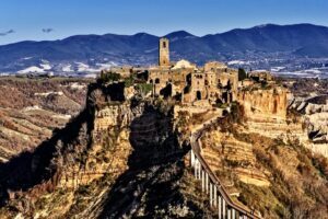
Cover Image, Top Left: View of Angkor Wat. Kalibri5, Pixabay
_________________________________
Advertisement