Heading north out of Cairo, Egypt, on the ‘Agricultural Road’ to Alexandria, it is a short drive of about one and a half hours to the Minufiyeh province. Today, Minufiyeh is a highly populated region, with very fertile land and crops in the fields year round. Agricultural practices are very different today than they were anciently. During the Pharaonic era and up until the raising of the first Aswan Dam at the turn of the 20th century, the population of Egypt depended upon the yearly inundation of the river Nile to bring water along with valuable fertile silt to irrigate and enrich the land. Driving through this region today, it is not easy to imagine the archaeological sites of the Delta, yet anciently the region was occupied from its western to its eastern desert edges. In the eastern Nile Delta, archaeological material dating to as early as the fourth millennium BC (the Egyptian Predynastic period) can be found on or close to the surface, and archaeologists have been working intensively in this region since the 1970s to locate and investigate both Predynastic and Early Dynastic cemeteries and settlements, as well as sites of later dates. One of these projects operates under the auspices of the Egypt Exploration Society (EES). Known as the Minufiyeh Archaeological Survey, it is carried out in the modern day province of the same name within the Nile Delta region (http://minufiyeh.tumblr.com/). The project is part of the Society’s Delta Survey (http://www.deltasurvey.ees.ac.uk/ds-home.html), and represents one of several international teams that are working across the Nile Delta today.
This has not been the first archaeological activity in the area. Early archaeologists and Egyptologists, including Sir William Matthew Flinders Petrie, worked at important sites here in the late 19th century. Other travellers and scholars, including Jean-Jacques Rifaud and Pascale Coste, left a record of monuments in the wider Delta as early as the 18th century, and French Egyptologist Georges Daressy surveyed areas, including the central Delta, in the early 20th century. Since the early 20th century, however, the southern central Delta has received little attention and our knowledge of sites in the area over time has been very limited. Part of the problem is logistical — due to the varied geomorphology of the Nile Delta, the central and western regions are heavily overlaid with sediment from the very same inundations that enabled settlement in the Delta since the late 6th millennium BC. Sites do remain, but the earliest settlements in the modern cultivated areas are accessible largely through use of de-watering equipment.
The purpose of the Minufiyeh Archaeological Survey is to develop new understanding about ancient settlements in the southerly reaches of the central Delta and the region stretching westwards to the desert edge. This project is aimed at surveying the central Delta to map the distribution of sites of all dates across this region and to consider what their relationships might have been to each other and with other sites across the country. There was also a special interest at the outset in 2005 regarding the possibility of locating prehistoric and early historic sites or temporary encampments.
The Minufiyeh Survey
As already noted above, the last major survey carried out in the southern central Delta was that by the French Egyptologist, Georges Daressy. He was working at a time when the region was much less densely populated and his reports, published in the journal Annales du Service des Antiquites de L’Egypte, have proved very instructive for the relocation of sites since 2005. Some of the sites that Daressy described are much altered today, with some features no longer visible within the modern landscape, e.g. red bricks associated with Roman baths. Some of the koms (an Arabic word used for mounds) he visited no longer exist, some have been greatly diminished in diameter, and still others were gradually built over. Reasons for these changes include re-use of ancient mudbrick, a building material valued for its qualities as a fertilizer, settlements being made on the koms, and the need for more agricultural land to support the rapidly expanding modern population in Egypt. The project re-visited findspots and sites recognized by Daressy, as well as those referred to on the Delta Survey of the EES or in other publications, detailing the state of preservation or the scope of archaeological evidence surviving in the mid 20th century, as compared to that previously recorded. Even with such variable and often sparse data, it all contributes to a better understanding of how the region functioned and also how it changed through time in response to environmental change (e.g. the movement of Nile branches), as well as the changing political climate. The methods for the survey were straightforward, including examination of maps (old as well as current), satellite imagery (since even levelled koms leave their mark on the landscape), and published material before going into the field. Out in the Delta the team made site visits, field-walked and, most important, engaged in discussions with local villagers and local inspectors of antiquities who have an intimate knowledge of the area. Visits were followed up at promising sites with geophysical survey, drill coring and, in a lower number of instances, small test trenches.
The results of the survey, which has been minimally invasive to date, have revealed that the majority of sites or findspots date to the Ptolemaic, Roman, Coptic and Islamic periods. These are sites in the main cultivated areas of the Delta. They number in excess of forty and consist of ceramic scatters with a low number of sites showing structural remains and/or stone blocks with inscriptions. Along the western Delta desert edge, however, the picture is strikingly different, because the material is no longer predominantly ceramic. It is lithic, dating from as early as c. 400,000 BP until the Neolithic (in Egypt, late 6th through until the end of the fifth millennium BCE). There is a Neolithic settlement only c. 4km south of the current survey area, a site that was discovered in 1928 by Herman Junker and the Austrian West Delta Expedition, and it is very possible that further settlements exist both to the north and south of Merimde Beni Salama. Scatters of lithics are currently distributed from the highest ground up on the desert edge, to the lowest levels, close to the modern canals, east of the Rosetta branch of the Nile. In 2013, the current team will be joined by new colleagues to begin a program of drill coring and geophysical survey in the region to help to re-establish the ancient environment and the extent and location of the ancient floodplain in order to assess where sites would logically have been placed. In the Neolithic and Predynastic periods the region became much more arid, although in the preceding Palaeolithic, a series of alternating arid and humid phases occurred. In complete contrast to the rest of the southern central Delta, there is very little ceramic material in this region, with the exception of a very few Predynastic sherds, infrequent scatters of late Ramesside period to Late Period sherds, as well as rare scatters of Late Roman, Coptic and Islamic (Ottoman), as well as modern ceramics. Due to the very early date of some of the lithics, most of the material will relate to periods during which there were temporary encampments, although until now no in situ material has been found due to the high level of ground disturbance due to recent agricultural expansion into the desert. Preliminary reports on the survey sites have been published in the Journal of Egyptian Archaeology for those who would like to read more; upon conclusion of the survey, more details will be published. Within this framework, the project was also committed to the re-investigation of one of the few known and registered (by the Supreme Council of Antiquities, since 2011 under the Ministry of State for Antiquities) sites in Minufiyeh, the Quesna cemetery.
_________________________________________________________________________________________
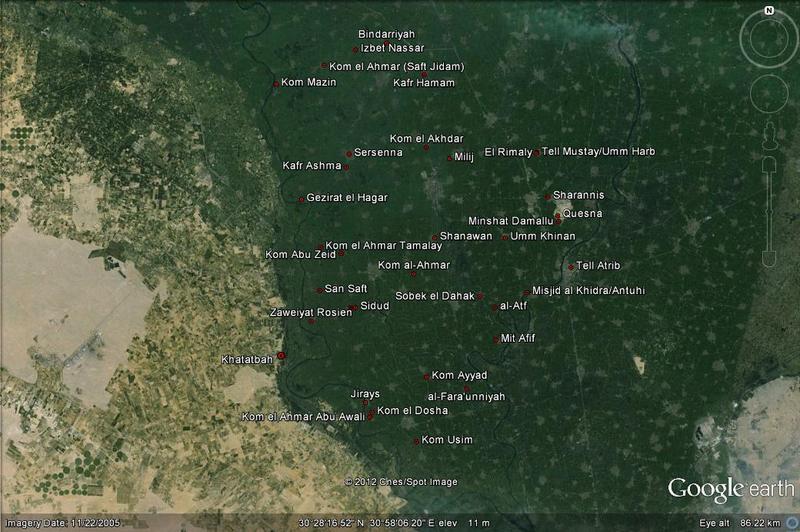
Figure 1. Location of selected findspots from Minufiyeh. Image: J. Rowland in Google Earth
______________________________________________________________________________________________________________________
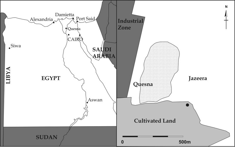
Figure 2. Location of Quesna. Image: K. Strutt.
_____________________________________________________________________________________________________________________
Quesna
The site of Quesna takes its name from that of the modern town c7km to its west, and is recorded as site 639 on the Delta Survey Database (http://www.deltasurvey.ees.ac.uk/queisna.html). The archaeological remains are located on top of a huge sand hill (Pleistocene gezira), which was the chosen location for a cemetery both for the local population as well as a place to honour the god depicted as a falcon, Horus, one of the earliest of the ancient Egyptian deities. The site was discovered during sand quarrying to the south of the site, when a large mud-brick structure was uncovered and the site registered under the control of the (now) Ministry of State for Antiquities (MSA). The structure proved to be a mausoleum that was in use from the Late Period until the Ptolemaic period (c747-30 BCE). Subsequent investigations and small test pits as well as open area excavations led to the discovery of a mud-brick structure which was used for the burial of falcon mummies, being offered up to Horus, as well as a cemetery consisting of pit and ceramic coffin burials of the Ptolemaic and Roman periods (c305 BCE-AD 395).
_________________________________________________________________________________________
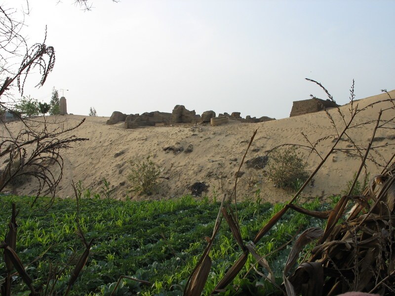
Figure 3. View from the south looking to the mausoleum, the first architectural features of the site found during the removal of sand. Photo: J. Rowland.
______________________________________________________________________________________________________________________
The questions that faced the new project team upon arriving at Quesna in 2005 were multiple: When was the site at Quesna first used, which communities within its vicinity did it serve, within which of the Egyptian provinces (later known as nomes) did it fall, and what was the original extent of the site before the modern sand quarrying began?Furthermore, it was important to gather information about the individuals that used the site, the positions they might have held, their occupations, as well as to assess their state of health, longevity and the demographics of the population. In order to begin to answer these questions, it was imperative to ascertain the original extent of the site represented by the sub-surface archaeological remains of the site today, as well as to assess the original size of the gezira. Both objectives were considered early on in the project, beginning in 2006-7 when a magnetometer survey was carried out by Kristian Strutt and Sophie Hay of the Archaeological Prospection Service of the University of Southampton, and when Mohamed Hamdan, professor in the Department of Geoarchaeology at Cairo University, led a team to conduct drill cores around the gezira. The drill coring was successful in re-creating not only a clearer picture of the original extent of the gezira, charting the depth of sand beneath the modern surface and the distance to which it persisted away from the modern extent of the gezira, but also in detecting the waterways that existed in close proximity to the site in antiquity. The waterways were determined by examining the sediments from the drill cores. This type of work contributes much to the knowledge of ancient landscapes, which in turn allows for a better and clearer understanding of site location. It also acts as a tool by which archaeologists can better anticipate the location of sites. The river branches running through the Nile Delta were neither constant in their position or in their number in antiquity, which further complicates the picture — but new research being conducted in Egypt today by multi-disciplinary international teams working along the length of the Nile Valley may soon help to clarify matters in the Delta.
_________________________________________________________________________________________
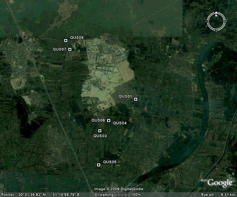
Figure 4. Location of the drill cores around the Quesna gezira. Image: J. Rowland in Google Earth.
_____________________________________________________________________________________________________________________
The magnetic survey carried out in 2006-7 confirmed that the western area of the gezira was dense in archaeological materials, from the southern to northern extents of the site, whereas to the east, there appeared to be little in the way of ancient remains. The anomalies that can be seen covering the site predominantly relate to burials, including ceramic coffins which show up clearly on magnetic surveys. In addition, the full extent of the falcon necropolis in the north of the site could be seen for the first time. This was supplemented in 2009 and 2011 when Kris Strutt returned to Quesna to trial ground penetrating radar survey (GPR) at the site. He succeeded in quite literally deepening our level of knowledge about the structures at the site, as GPR data can inform on the presence of materials/features beneath the surface at various depths. The magnetic map had produced valuable horizontal data, although little indication of depth. Combined with the GPR results, this has subsequently allowed the team to precisely locate excavation trenches to help provide answers to the initial research questions.
Excavation under the current project began at Quesna in the 2007 season. Two trenches were opened. The first was placed to assess whether the Ptolemaic-Roman cemetery began directly to the west of the mausoleum. The second was to locate the entrance structure to the falcon gallery, indicated by the results of the magnetic survey. In Trench 1, burials within ceramic coffins and simple pit burials were found just beneath the surface, which does not necessarily mean that this was originally the case, since the depth might have been affected by environmental or other changes in the landscape over the past two thousand years. The burials revealed in Trench 1 did not suggest that the individuals had held any substantial socio-economic wealth, in contrast to the finds that had been made in the mausoleum, which included ceramic and numerous ushabtis (figures that accompanied the deceased into the afterlife to carry out work for them) and amulets of various materials. Although there was a general lack of grave goods, the location of packing material variably in the mouth, thorax, pelvis, abdomen or legs, or even on the face, indicates varying degrees of mummification, although none comparable to the fine mummification of some individuals indicated in the reports from the Egyptian excavations in the mausoleum. This concurs with the writings of Herodotus who described several different degrees of mummification depending upon the resources available to the individual. A number of different osteologists have worked in the cemetery since 2007 — Scott Haddow, Sonia Zakrzewski, Sarah Inskip and Lawrence Owens — and their research has provided much new data about the medical conditions as well as injuries and damage/healing to the bones themselves. Such data can help to clarify the types of activities with which the population was involved, although without accompanying textual or pictorial information, it is not easy to suggest exactly which exact occupations which individuals had practiced. Nevertheless, it can indicate, e.g., whether individuals had been habitually in a squatting position, or a position similar to that assumed by individuals when grinding grain. Another interesting observation has been the non-fusion of long bones on a low number of individuals, where the dental and pelvic data have suggested an age by which the fusion should have been complete. This is considered to possibly be the result of an endocrine disorder and incidences of this condition included one individual in Grave 1014 who died at age 15-24 years, and another in Grave 1019 (Burial 21), where examination of the teeth would suggest an age at death of 16-22 years, although age ranges based on the post crania suggest 18-19 or 15-24 years of age. Another individual presenting the same condition was excavated during the 2011 summer season, a tall individual (Burial 72) at 1.80m, and whereas the teeth suggested an age of 21 years, the non-fusion of some bones suggested a much younger age of 12-15 years. It is possible that some of these individuals either held an important position (possibly religious) during life, or, that their condition was such that they were provided with extra luck as they made the journey into the afterlife, although Burial 72 had no associated amulets or other grave goods. The individuals described here have been suggested as male due to their large stature. Burial 21 in Grave 1019 was provided with amulets of many different types made of plaster, scarabs, a ‘Hathor’ head, a sphinx, winged figure and simple discs or buttons.
_________________________________________________________________________________________
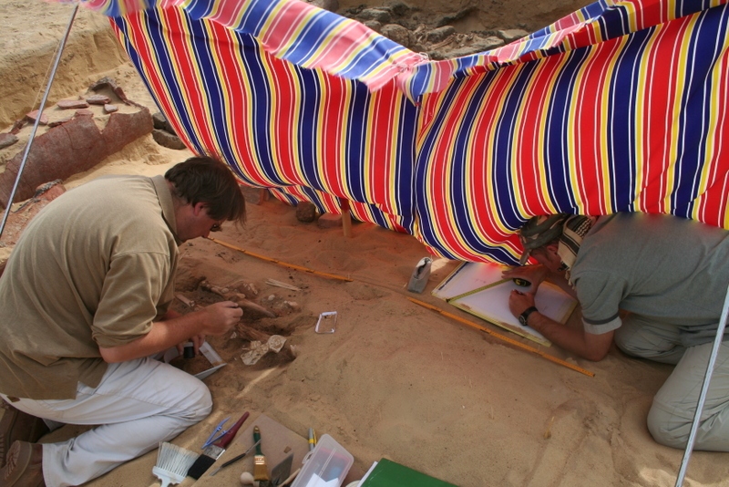
Figure 5. Joris van Wetering (left) carefully uncovering the plaster amulets lying on top of Grave 1019 (left), whilst Scott Haddow (right) plans the burial. Photo: S. Zakrzewski.
________________________________________________________________________________________________________________________
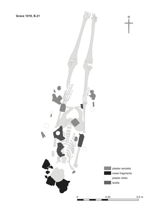 Figure 6. Plan of Burial 21, in Grave 1019 showing the location of the amulets across the body. Digitised image: C. Mazzacuto from plan by S. Haddow.
______________________________________________________________________________________________________________________
These amulets were laid all over the body and following excavation, our conservator Stavroula Golfomitsou succeeded in consolidating not only the amulets and fragments thereof, to prevent their disintegration, but also in starting to piece together the many fragments of plaster that had originally formed a single object – a face mask. The mask has recently been worked again, as Richard Jaeschke prepares the pieces for mounting on a backing cloth to re-create the original shape of the mask.
_________________________________________________________________________________________
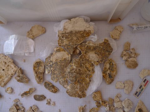
Figure 7. Restoration of the face mask from Burial 21 in progress. Photo: R. Jaeschke.
_____________________________________________________________________________________________________________________
A second burial in Trench 1 also revealed amulets, although in this instance the individual did not display evidence for the same medical condition. The burial in this grave, Grave 1021, was placed within a ceramic coffin, although only the western vessel and upper body of the individual remained. The upper body was covered in plaster scarabs, all with their heads to the west, scarabs that had been made in moulds, and radiating out from around the head of the deceased were plumed crowns. There was even evidence of gold leaf remaining by the face, and this individual might also have originally had a face mask.
_________________________________________________________________________________________
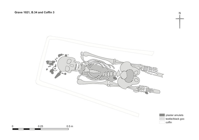
Figure 8. Plan of Grave 1021, Burial 34 in Coffin 3, showing the location of the plaster crowns around the head and the scarabs on the body. Digitised image: C. Mazzacuto from plan by S. Haddow.
______________________________________________________________________________________________________________________
A small amount of additional information for the provision of cartonnage in burials, found on the body, and also gold foil, has been found, although it is the exception rather than the rule. One of the individuals with traces of gold on various bones was found in the summer of 2012 in Trench 9, an individual within a multiple burial (Grave 1067) in a grave surrounded by a single to two-course wall of mud-bricks, bricks which had fragments of plaster remaining, including plaster that had been painted. The connection between the individuals in this and other multiple burials at Quesna is not certain, although in this instance adults and children had been buried together, with a definite total of four, and possibly five burials. The burials were all oriented with their heads to the east, not the most common position at Quesna, laid out on their backs with heads up (normal position across the site), and all were buried at approximately the same depth. Multiple burials, from the excavations to date, are not frequent in number at Quesna, although Grave 1014 in Trench 1 contained five burials. It was quite unlike Grave 1067 in that the burials had been made at three different levels, and sediment between the second row of burials and the final interment detected by the osteologist suggests that the final burial might have been made at a later date. All but one of the burials had their heads to the west, the other outstretched with the head to the east, and the final burial had no skull at the time of excavation. This tomb was also constructed with mud-bricks, although of smaller scale than Grave 1067, and the top layer of bricks were very disturbed when the tomb was discovered, which suggests that robbery resulted in the missing skull. Mud-brick as well as burned red-brick burials have also been found in Trench 1 and Trench 9, with two single mud-brick covered burials in Trench 1, one oriented east-west, and the other north-south, with the red-brick surrounded burial in Trench 9 oriented east-west.
Both burials in Trench 1 contained older females. A female aged 50+ was buried in Grave 1004, who probably suffered with osteoporosis and who had no teeth remaining when she died. The individual in Grave 1005 was aged between 45-60 years, also with osteoporosis and with no teeth remaining. This female also suffered from osteoarthritis. The majority of coffin burials are varieties of double-vessel types, with a lower frequency of tray coffins, coffins that were made as one piece and placed over, although not under the deceased. The first publication of the results from the excavations in the cemetery by the project will be available before the end of 2012.
_________________________________________________________________________________________
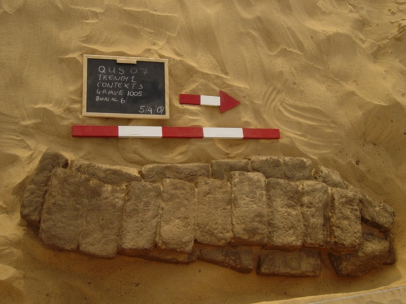
Figure 9. Mudbrick burial Grave 1005, Burial 6. Photo: P. Popkin.
______________________________________________________________________________________________________________________
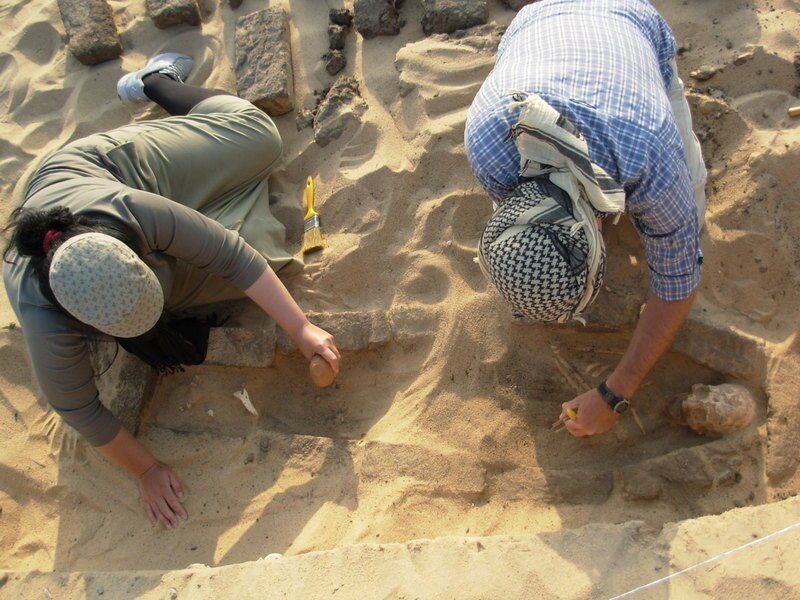
Figure 10. S. Golfomitsou (left) and S. Haddow (right) uncovering Burial 6, in Grave 1005. Photo: N. Billing.
______________________________________________________________________________________________________________________
In addition to the work in the cemetery, there are two other areas at the site which have been under investigation by the current team and which can be introduced here. One of these was discovered by the MSA and excavated during the 1990s: the sacred falcon necropolis. Up until the summer 2012 season, there have been five trenches excavated within this structure. Trenches 2 and 3 were located in the entrance structure, at the southern entrance and in the northwestern corner, with Trenches 12, 13 and 15 directly to the south and the east of the area excavated by the Egyptian team in the 1990s. Trenches 12 and 13 were located due to the results of the GPR survey, which suggested that the corridors of the gallery continued further south than had originally been thought.
The entrance to the gallery was from a building on the western end of the structure. Constructed of mud-brick, a series of corridors running under arches led into a large room which appears to have been one of the access points to the gallery, as the fallen remains of mud-brick arches were detected in the eastern baulk of the trench. From here the galleries run over 100m in an easterly direction. Cut marks into the mud-bricks in the south and north of the entrance structure suggest robbing in antiquity, further confirmed by the presence of broken limestone pieces, including a decorated small column capital and possible decorative elements for door arches. Further to the east, in the galleries themselves, however, there are some areas that have not been subjected to heavy robbery. The main walls running through the galleries have been damaged and cut in the past, but it would seem more likely, based on associated evidence, including tiny fragments of gold and scattered human remains, that these cuts into the walls were in order to place burials within this sacred place. This interpretation is strengthened by the fact that burials were also placed in the walls of the mausoleum in the south of the site.
_________________________________________________________________________________________
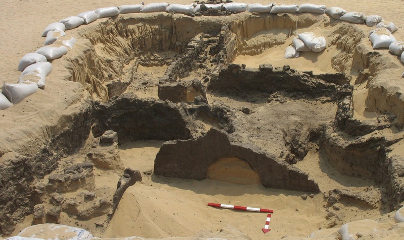
Figure 11. Looking south over the entrance structure to the corridors of the falcon necropolis. Photo: J. Rowland
______________________________________________________________________________________________________________________
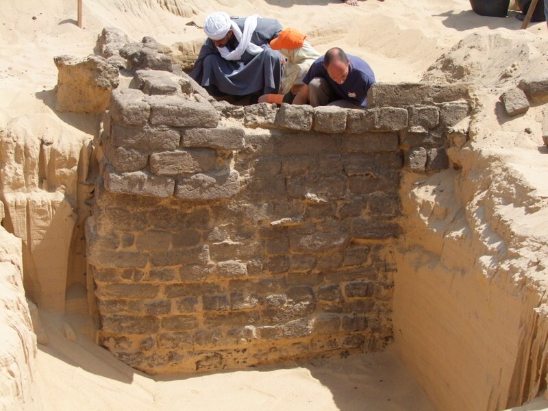
Figure 12. The repaired northwestern corner of the entrance structure to the falcon necropolis during excavation by Ashraf Amir, Laila Mohamed El Fatamawy and Daniel Jones. Photo: J. Rowland.
______________________________________________________________________________________________________________________
Trenches 12, 13 and 15 allowed the team to better understand the main structure of the galleries, to detect the sloping walls which would have originally met beneath mud-brick arches. There are also dense deposits of bird mummies here in the galleries, deposits which stretch from wall to wall and which a specialist in animal remains, Salima Ikram, who examined the galleries in the summer of 2012, has suggested would have been laid down layer by layer, with the areas being bricked off once they were full. Although no totally complete ceramic jars have been found in the galleries, it is clear from the 1990’s MSA excavations that a certain type of jar, frequently encountered in the current excavations, had been found filled with falcon eggs and also with mummified remains.
_________________________________________________________________________________________
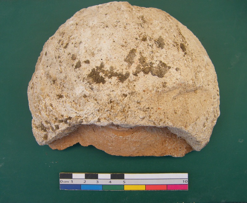
Figure 13. One of the jar stoppers from the ceramic jars which could contain mummified remains or bird eggs. Photo: G. J. Tassie.
_____________________________________________________________________________________________________________________
Late Finds
As is typical, the most exciting finds are often made as the excavation season comes to an end, and during final cleaning in preparation for photography and planning, the eastern back wall of the original structure was detected, with a series of later walls running eastwards. Investigations will have to continue in a future season, and it is not yet possible to date the later the extension, but the walls were definitely not continuous. They abutt each other. The expert cleaning that revealed this fact was made by one of our Qufti workforce who was working with the project’s assistant director, G. J. Tassie. The ‘Quftis’ come from the town of Quft in Upper Egypt, just north of modern Luxor, where men were first trained in archaeological excavation skills by Flinders Petrie. The team at Quesna has much appreciated their archaeological and logistical input since Rais Omer Farouk el-Quftawi and his men joined the team in the spring of 2010.
________________________________________________________________________________________
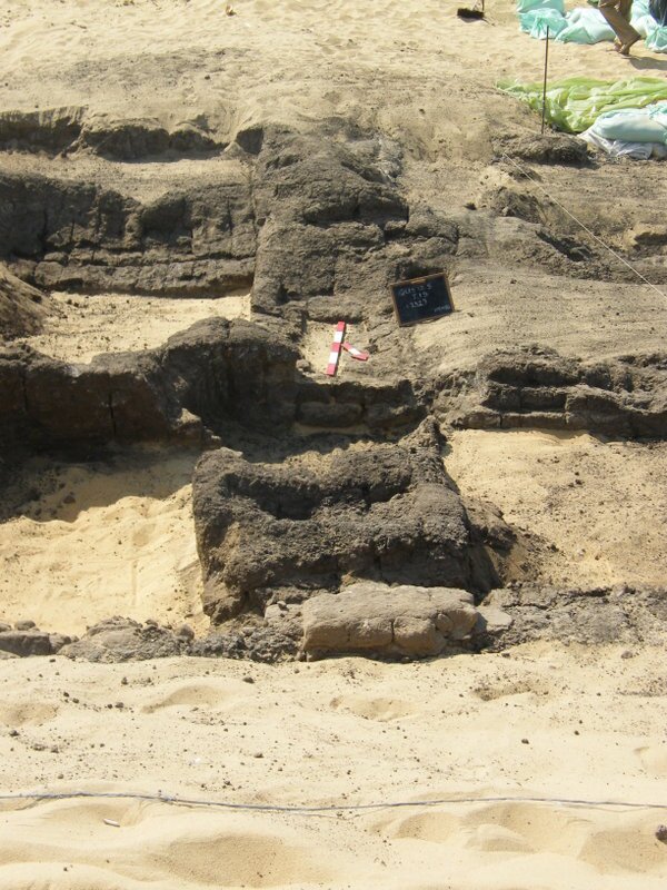
Figure 14. View over the possibly original back (eastern) wall of the falcon necropolis at the point where slightly thinner east-west running walls are abutting it. Looking south. Photo: G. J. Tassie.
______________________________________________________________________________________________________________________
Several connections are possible between the site of Quesna and nearby Athribis, which lies close by in the modern city of Benha, c4km as the crow flies. One of these connections may relate to the falcon gallery. Inscriptions on statues/statue bases from Athribis identify an individual of the name Djed Hor Pashed (Djed Hor the saviour) who was connected with the cults of Horus at Athribis, most probably in the 30th Dynasty. When the various inscriptions were examined, there was no knowledge of the falcon necropolis at Quesna, because it was only found in the 1990s; however, it is possible that Djed Hor might have overseen the worship of the cult of Horus at Quesna and perhaps might have been responsible for the building of at least part of the structure. Inscriptions that were found in the mausoleum at Quesna also tell of priests related to the cult of Horus Khenty-Khety, which has been associated with Athribis since Middle Kingdom times. These include a priest of Osiris, Hor-Wadja, the sarcophagus of whom was found by the MSA, and which now can be found outside the Egyptian Museum in Cairo.
Due to its geographical position and the changing political organisation of the country, Quesna appears to have fallen under different provinces (later called nomes) at different periods of history. Quesna has been attached to Athribis, to Mustai, (which is just a short distance to the north) and also possibly even to Busiris, some distance further north. To which nome, however, might Quesna have been attached before the Late Period? There is one more discovery that was made at Quesna in the spring of 2010 that can be briefly introduced here. Surprisingly, during the cleaning and initial excavation of the sediment above another mud-brick structure, this time on the very northern edge of the Quesna gezira, ceramic sherds were found which were quite unlike anything else found at the site. It was quickly realised by a ceramicist from the Fayum, team-member Ashraf el-Senussi, that these were not ‘late’ pottery sherds, but rather fragments of jars known commonly as beer jars or offering jars. They were found in great numbers across the top of the structure. Fortunately, due to the variations in the typology of these beer jars, it is possible to associate them with quite tight chronological spans and in this instance the types found have been dated at the earliest to the late 3rd Dynasty and at the latest to the reign of Khufu, the king interred in the Great Pyramid at Giza. The structure is large, with its maximum extents of 17m north-south and 13m east-west, and is built of mud-bricks up to c0.50m in length, another indicator of the early date of the structure. This mastaba tomb (named after the Arabic word for bench) had been badly damaged, possibly at various points in antiquity, when robbers had searched for the burial shaft leading down to the subterranean burial chamber with its provisions for the afterlife. Although the surface of the structure was excavated and planned in 2010, it is currently backfilled and waiting beneath the surface for new investigations, hopefully in 2013, which should reveal the location of the burial shaft and whatever fragments of the original provisions that remain. To help the team understand more about the individuals at the site and relationships with other sites already in the Old Kingdom, a period including Athribis is known through textual references (including the 5th Dynasty Palermo Stone). The preservation of mud-seal impressions would be helpful in providing a possible personal name, or the title of a position held by the individual for whom the mastaba tomb was built.
_________________________________________________________________________________________
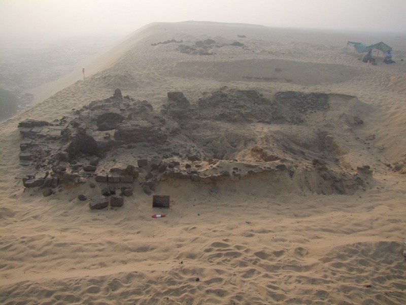
Figure 15. A view from the west over the Old Kingdom mastaba structure. Photo: J. Rowland.
_____________________________________________________________________________________________________________________
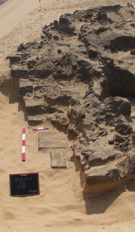
Figure 16. Close up showing the stepped façade of the mastaba structure (northern wall). Photo: J. Rowland.
_____________________________________________________________________________________________________________________
The work proceeds and in the course of the team’s fieldwork during the past two summer seasons there has also been a training school for Egyptian antiquities’ inspectors, university students from the University of Minufiyeh in nearby Shibin el-Kom, and students from the Freie Universität Berlin, where the author is currently based. The training focuses on archaeological field techniques covering all aspects of recording excavations, orienting trenches, taking levels, single-context recording (based on the Museum of London Archaeology’s methodology), planning, analysis and excavation of human skeletal remains, archaeological photography, as well as basic field conservation and the principles of analysis and recording of ceramic finds. This has been conducted in cooperation with our colleagues at the MSA, to whom thanks are given, and also with the Egypt Exploration Society, the University of Minufiyeh and, in 2012, the Freie Universität of Berlin. Funding for the fieldschool has been provided by the Deutscher Akademischer Austausch Dienst. Funding for the fieldwork in Minufiyeh has been generously provided since 2006 by: the British Academy Small Research Grants, the Egypt Exploration Society (including the Centenary Award and the Amelia Edwards Project Grants), the Gerald Averay Wainwright Near Eastern Archaeological Fund, the Society of Antiquaries of London, the John Fell (Oxford University Press) Fund, the Society for the Promotion of Roman Studies, The Michaela Schiff Giorgini Foundation, the Rutherford Press Limited and the Seven Pillars of Wisdom Trust. Sincere thanks go to the MSA in Cairo and also in Minufiyeh and to the inspectors who have accompanied us since 2005. We also exetnd our gratitude to all past and present team members.
_________________________________________________________________________________________
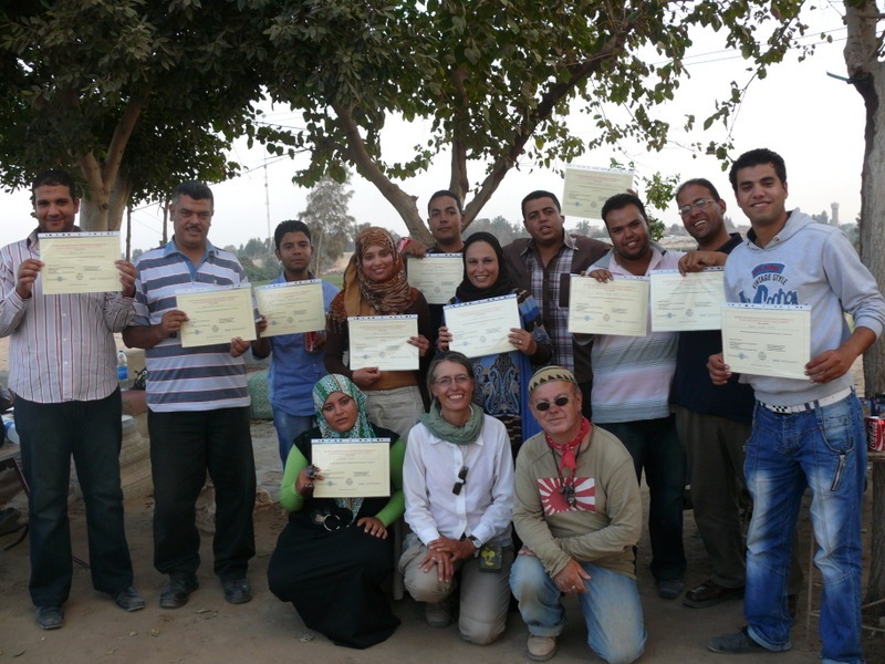
Figure 17. The Egyptian fieldschool students receiving their certificates in October 2012. Photo: O. Farouk.
_____________________________________________________________________________________________________________________
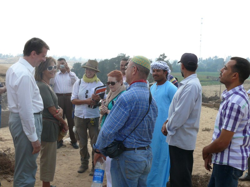
Figure 18. His Excellency Mr James Watt the British Ambassador to Cairo, Mrs Amal Watt and Ms. Jane Rawbone, during their visit to Quesna in September 2012. Photo: R. Abd el-Galil.
_____________________________________________________________________________________________________
More about work being conducted in Egypt under the auspices of the Egypt Exploration Society can be found in the article entitled Romancing the Stones of Egypt in the June 2012 issue of Popular Archaeology.
_____________________________________________________________________________________________________
SUPERIOR QUALITY CONTENT AT LESS COST. Read about the most fascinating discoveries with a premium subscription to Popular Archaeology Magazine. Find out what Popular Archaeology Magazine is all about. AND MORE:
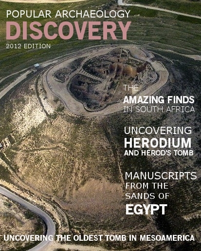 Popular Archaeology’s annual Discovery edition is a selection of the best stories published in Popular Archaeology Magazine in past issues, with an emphasis on some of the most significant, groundbreaking, or fascinating discoveries in the fields of archaeology and paleoanthropology and related fields. The 2012 edition content includes no less than 41 specially selected premium or top quality feature articles and news articles covered over four or more issues. At least some of the articles have been updated or revised specifically for the Discovery edition. We can confidently say that there is no other single issue of an archaeology-related magazine, paper print or online, that contains as much major feature article content as this one. Go to the Discovery edition page for more information.
Subscription Price: A very affordable $5.75 for those who are not already premium subscribers of Popular Archaeology Magazine. It is FREE for premium subscribers. Premium subscribers should email [email protected] and request the special coupon code.

