

In 1881, after three years of travel throughout the Sierra Nevada de Santa Marta mountains in Colombia, South America, the British explorer, naturalist and geographer Frederic A.A. Simons published the first detailed map of the mountains in the Proceedings of the Royal Geographical Society of London. It included a brief description of the Sierra Nevada, its watershed, the indigenous population, and the surrounding towns. It was indeed the first relatively precise map of one of the highest coastal mountain systems in the world, which reaches heights over 19,000 feet above sea level within a scant 25 miles of the Caribbean coastline. Interestingly enough, the map included the supposed location of Posigueica, the fabled capital of the Tairona, the prehispanic peoples inhabiting the area when the Spanish first arrived in the first decades of the 16th century.
After the paper was read in an evening Royal Geographical Society meeting, there followed a question and answer session in which Sir Clements Robert Markham, president of the Society, asked Mr. Simons a question of enduring influence and consequence for all subsequent researchers. He asked “whether there was any trace of the Taironas, one of the most warlike tribes ever known in South America, who, after several battles, drove the Spaniards back to Santa Marta, or; whether they had been wholly exterminated.”1 Simons then answered that it seemed that they had been “completely exterminated and replaced by tribes coming in from the Orinoco”.
What, indeed, actually became of the Tairona? For all accounts and purposes, they had disappeared completely after the 16th century.
________________________________________
 The Simons map
Frederic Simons’ was the first relatively accurate map of the Sierra Nevada de Santa Marta up until 1939 when the Cabot Expedition for the American Geographical Society conducted a photogrammetric survey. It served as a basis for all maps of the Sierra Nevada up until WWII. The red lines index his travels throughout the massif. (The map appears in Simons 1879 article for the Royal Geographical Society. This is a composite image created by the author.)
________________________________________________
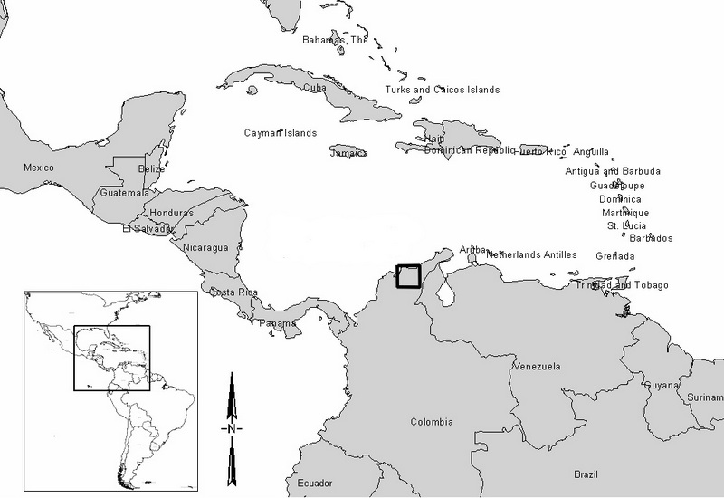 Map showing the Sierra Nevada de Santa Marta region within its geographic context in northern Colombia. Credit Santiago Giraldo
_________________________________________________
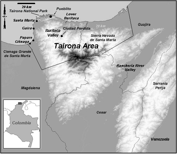 The Sierra Nevada de Santa Marta showing very general limits to what is considered to be the area inhabited by the Tairona up until the end of the 16th century, in relationship to the present-day nearby geographic areas and town/archaeological sites. Credit Santiago Giraldo
_________________________________________________
The Discovery
Our knowledge about these fabled and little known polities who held sway over the northern and western reaches of the Sierra Nevada de Santa Marta has slowly improved over the past 100 years. Known primarily for their intricate gold work exhibited at the Bogotá Museo del Oro (Gold Museum) and other museums in North America and Europe, the Tairona built large towns and urban centers up and down the numerous rivers flowing downwards from the snow covered peaks.2 They were prolific artisans, and though less known, their stone beadwork, bone and wood carvings, and pottery are also outstanding. Their featherwork and textiles, though described as fabulously ornate and beautiful by the Spanish conquistadors, have not survived.
Up until the 1970s, only five archaeologists had actually worked in the area around Santa Marta: John Alden Mason with the Field Museum of Natural History in Chicago in 1922-23, Gregory Mason for his dissertation at the University of Southern California in 1936, Gerardo Reichel-Dolmatoff and his wife Alicia Dussán between 1946 and 1949, and Henning Bischof in the 1960s.3 Their work concentrated on coastal sites currently located within Tairona Natural Park (Parque Nacional Natural Tairona), and it was Alden Mason’s research that led to the initial discovery of Pueblito, a large Tairona town where he excavated most of the objects currently on display at the Field Museum of Natural History in Chicago. Subsequent investigations by Reichel-Dolmatoff and Dussán, and Bischof made it the best-known Tairona town until the discovery of Teyuna-Ciudad Perdida. Despite their work, little was known about the extent of Tairona settlements in the general area, and there was next to no information on towns and sites located higher up on the mountain slopes. 19th century travelers such as Simons and Elisée Reclus, the French anarchist geographer, mentioned in their writings that they had seen and walked upon long staircases and stone-paved paths that wound their way up the mountain, so it was highly probable that Tairona towns and settlements were not confined to the coast. Yet no archaeologist had explored the upper slopes of the mountain. Covered in tropical forest, with a broken topography that makes movement and exploration incredibly difficult, it was not until the 1970s that the extent of Tairona settlements on the northern and western sides of the mountain became clear.
Beginning in 1973 and up until 1976, the Instituto Colombiano de Antropología-ICAN (Colombian Institute of Anthropology) began an ambitious project led by two of its archaeologists, Luisa Fernanda Herrera and Gilberto Cadavid, whose objective was to systematically survey as many river basins as possible on the western and northern sides of the mountain, locating Tairona settlements throughout the area.4 Around the same time (1973), Paul Bahn, Richard Luckyn, and Patrick Jacquelin, who were then students at Cambridge University, organized an expedition to survey the Mendihuaca, Buritaca, and Don Diego rivers on the northern side of the mountain.5 Jack Wynn, a U.S. archaeologist, was also conducting fieldwork for his dissertation in the lower Buritaca River. All things considered, either one of the three projects/expeditions could have found Teyuna-Ciudad Perdida. It was simply a question of time, timing, and a bit of luck. When Paul Bahn and I met in 2009 in New York for lunch and he kindly gave me his copy of their expedition’s report, he expressed that not finding Ciudad Perdida had been a sore disappointment. In fact, the disappointment is shared by many of us, for no archaeologist discovered Teyuna-Ciudad Perdida. By the beginning of 1976 however, Herrera and Cadavid had located 199 Tairona villages and towns that spread from the western to the northern side of the mountain.6 The extent and density of the settlements was a surprise, and served to show that the 16th century Spanish documents describing the Sierra Nevada as “full of peoples and towns” were not an exaggeration.
As the story was narrated to Luisa by the guides during the trip, it was in fact Julio César Sepúlveda, the son of a professional looter by the name of Florentino Sepúlveda living nearby on the Guachaca River, who happened to find the city during a hunting trip, some time around 1975.7 A bird he shot fell on an exposed stone step of the staircase that led up to the site. At that time, the Sierra Nevada de Santa Marta was literally crawling with looters in search of Tairona gold, and over 5,000 of them were employed by various patrons who funded their looting expeditions. The Sepúlveda family began to quietly and systematically loot the town, but other “guaqueros” (looters) soon got wind of the fabulous gold objects they were finding and tracked them up the Buritaca River. As usually happens in this line of business, the rival crews worked out who had “rights” over the area with shotguns and rifles. In the ensuing firefight, Julio César was killed, and the word spread like wildfire among the looters that a fabulous Tairona city in the Buritaca had been found and that “guaqueros” were killing each other over the gold. In the aftermath, one of the patrons, a man by the name of Jorge Barón who had funded the looting expeditions to the site, unexpectedly contacted the director of the Gold Museum in Bogotá and proposed a “joint venture”, wherein they would share the profits of the finds. Utterly perplexed by this strange offer, the director of the Gold Museum alerted the director of ICAN, who in turn called upon Louisa and Gilberto to set up an expedition to this place out in the middle of nowhere – a place that guaqueros were calling “el infierno” (hell) due to its remoteness and isolation.
Reaching Teyuna-Ciudad Perdida by foot today usually takes visitors 4 to 6 days round trip, with plenty of strenuous hiking along a 16 mile trail. At that time, however, there were no open trails, outfitters or guides, and the upper sections of the Guachaca and Buritaca rivers were completely uninhabited. Faint hunting tracks criss-cross the forest, and it is very easy to get lost or disoriented. A few homesteaders lived further down river and indigenous Kogi families had just begun colonizing the upper sections of the watersheds, which were completely covered in tropical montane forest and had been completely uninhabited for almost 400 years. No one, apart from the “guaqueros” actually knew how to get there.
The archaeologists traveled to Santa Marta and spoke with Jaime Barón, who introduced them to two of the looters who had been “working” the site and had agreed to guide them. Bernardo Valderrama, an architect, and Lucía Rojas, another archaeologist working for ICAN, had also joined the team by then. Given the difficulties of reaching the site on foot, an army helicopter was chartered, and the looters were able to lead them up the river canyon up to a narrow hill overlooking the Buritaca River at an elevation of 3300 feet above sea level. The hilltop was completely covered in dense forest; with towering Tagua palm trees over 120 feet high that made it impossible to land. The pilot suggested they lower themselves by rope, but without knowing how far below the canopy they would find solid ground, the idea was extremely risky and reckless, so they rapidly abandoned it after some discussion. The team was forced to go back to the military base and approach the site on foot, crossing the Guachaca River basin and then slowly moving up the Buritaca River until they reached the partially exposed staircase the looters were using to climb up to the site.
It took the team five grueling days to reach “el infierno”, sleeping under a plastic tarp and palm leaf shelters in the forest to protect themselves from the nightly downpours. Along the way, Lucía Rojas had to stay at a homesteader’s farm because her feet, according to Luisa, had become a single large blister that made it impossible for her to walk. The guides insisted that “no woman” had ever made it to “el infierno”. Rivers and streams were crossed several times and they were constantly wet and cold beneath the rainforest. The idea of turning back reared up its ugly head a few times, but according to Luisa, she was willing to head up to the site accompanied by a single guide if need be. In the end, Luisa, Gilberto, and Bernardo reached the site with their two guides, “El Negro” Rodríguez and Franky Rey. (Franky later on became the first foreman and site administrator for Teyuna-Ciudad Perdida Park). What they found soon became Colombia’s most important archaeological find in the 20th century and an iconic archaeological park for Colombia in general.*
The team camped out at the site for three days under a palm frond shelter, rationing their meager supplies that were attacked on a nightly basis by opossums and rats. Wet and bedraggled from the constant rain, mud, and the evening fog that completely covered the hilltop, they began clearing out bits and pieces of the site. As they explored the forest-covered town, they could see the lunar-like landscape left by the looters: scores of holes and broken potsherds littering the forest floor. But by lightly clearing some areas they also became aware of the stone masonry walls, staircases, and flagstone paved terraces that were everywhere. The more they cleared the more they found, and as Luisa has often told me when we discuss that moment, the visible remains of stone structures simply kept going on and on along the ridgeline and slopes of the hill top. After three days, their food ran out and they were forced to head back to the trailhead and from there on to Santa Marta. Back in Bogotá, they tried to explain to ICAN’s director, Álvaro Soto, the significance of what they had seen.
By June of 1976, ICAN set up a major research and conservation project that spanned 5 years, opening Teyuna Ciudad Archaeological Park to the public in 1981. Officially, Louisa and Gilberto named the site “Buritaca 200”, given that it was the 200th Tairona site they had found and it was located on the Buritaca River basin. Bernardo Valderrama, the architect who was with them, is responsible for the name “Ciudad Perdida”, The Lost City. Much sexier than “B-200”, the moniker stuck and by the mid 2000s the name of the park officially became Teyuna-Ciudad Perdida Archaeological Park. Additional work between 1981 and 1986 led to the discovery of another 26 Tairona villages and towns of varying sizes located in the surrounding area. Since the park was opened, ICAN (now ICANH, Colombian Institute for Anthropology and History) has been in charge of research, conservation, and management.8 Two structures, a nuhue and a huitema, ceremonial houses used by kogi men and women respectively, were built in 1999 to accommodate the periodic rituals carried out by the indigenous community that now lives in the area.9
_______________________________________________
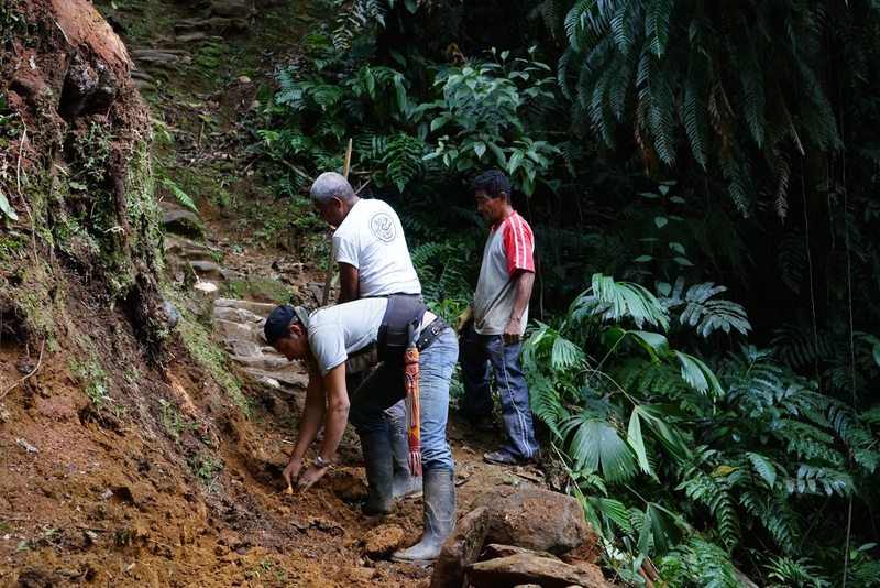
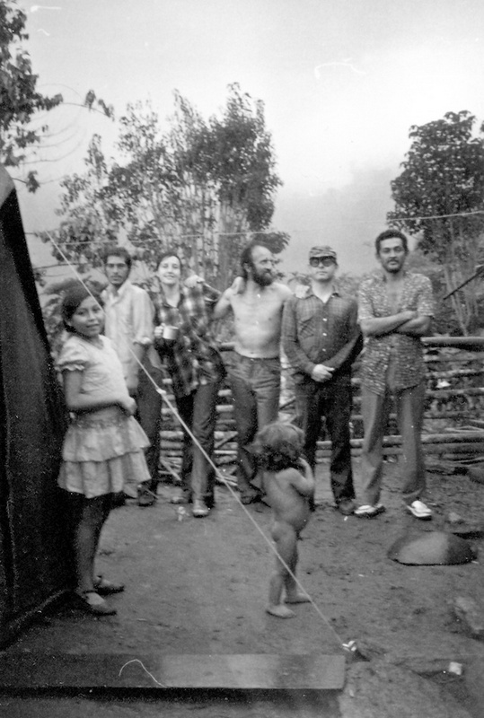 The team arrives on the third day at the farm of a homesteader by the name of Gertrudis. Lucia Rojas had to remain here due to blistered feet. (L to R) “El Negro” Rodríguez, Louisa, Bernardo, Gilberto, Franky. Courtesy Louisa Fernanda Herrera
_________________________________________________
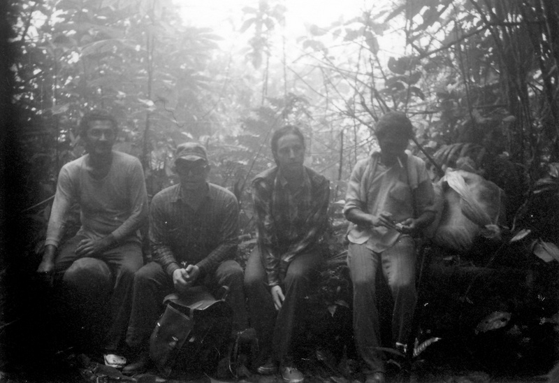 The team resting on a fallen log after a four-hour climb to the top of “amansa guapos” (man tamer) hill on the way to Ciudad Perdida. Note the dense forest fog surrounding them. (L to R) Franky, Gilberto, Luisa and Rodríguez. Courtesy Luisa Fernanda Herrera
________________________________________________
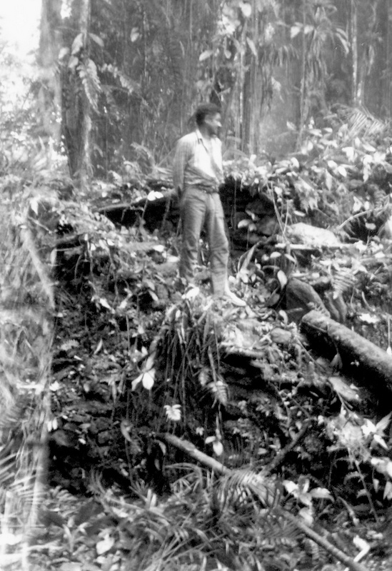 Franky Rey, the looter who would go on to become Ciudad Perdida’s first administrator, standing atop a vegetation covered staircase. Courtesy Luisa Fernanda Herrera
________________________________________________
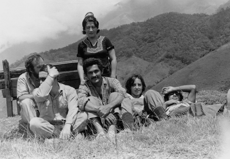 Left to right, Bernardo, Lucia, Gilberto, Frank, Luisa, and “El Negro” Rodriguez resting after the expedition to Ciudad Perdida. Courtesy Luisa Fernanda Herrera
________________________________________________
Research and Conservation from 1977-2014
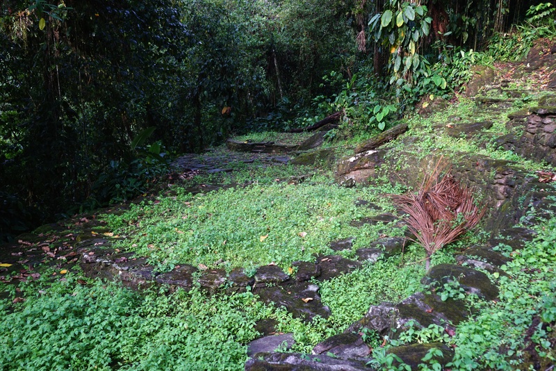
What visitors see today when they reach Teyuna-Ciudad Perdida is the product of 37 years of research and conservation work. The areas of the town, or city if you will, that are currently open to the public extend over 80 acres, but the protected area comprises over 400 acres and includes three additional sites that are not open to the public: Garage 1 and 2, and B-201, which are currently under research. During the initial phase of the ICAN project, 85% of the town was cleared and restored, with excavation work concentrating on domestic structures. When the archaeologists arrived in June of 1976, it became apparent that looter crews had returned and practically destroyed some of the more important structures in their hurry to find whatever gold they could before the site was closed to them by ICAN. Much conservation work in those years entailed fixing this damage, but the town is large enough that numerous structures went untouched. Unfortunately, the looters did get away with many of the most spectacular finds, which were gold and pottery objects associated with single burials located within the rammed earth and stone masonry terraces. None of these objects, all acquired by private buyers, have been recovered.
Teyuna-Ciudad Perdida was laid out over the hilltop in such a fashion that its administrative and political center covers a narrow ridgeline, with residential wards located towards the slopes. The ridgeline and slopes were leveled out using a combination of rammed earth and masonry terraces, and round buildings with stone foundations were set upon them. A 10,000 square foot terrace, for example, has multiple round or oval buildings and is connected to adjacent terraces via paved walkways or staircases. At this point, less than 10% of the town has been excavated, but more importantly, for the first time archaeologists were able to understand what a Tairona town actually looked like. It has been fully mapped and surveyed twice, the first time by Guillermo Rodriguez and Margarita Serje in 1980, and the second time by an ICANH-Global Heritage Fund archaeological and topographic survey crew in 2011.
One of the more striking features of Tairona architecture and settlement layout (that became apparent as the site was slowly uncovered), is its apparently informal, curvilinear, low-density, and spacious quality, with residential wards and ceremonial/feasting areas spread out over extremely broken, mountainous terrain. In contradistinction to most other early towns and cities studied by archaeologists in the Americas, where square or rectangular rooms along with masonry walls, corridors and doorways are used to parse out, divide, subdivide, and restrict built space, Tairona settlements make use of open terracing without walled divisions and emphasize roundness in built structures. For most visitors, this makes it quite difficult to understand what was used for what purposes, since most everything looks exactly the same and functional differences between structures have to be teased out through excavation.
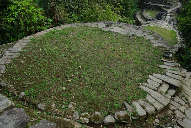
The open architecture that is a characteristic of Tairona towns makes it very difficult to know what constitutes private or public space. In a town such as Ciudad Perdida that by A.D. 1500 would have had 2500 to 3000 inhabitants, everyone would have been on view to everyone all the time as they moved about or worked in the open spaces and patios. Circulation and movement throughout the town would have been completely unrestricted, with multiple paths available for reaching different areas. In other words, unlike our own circulation pattern, which enforces movement along prescribed pathways using walls and corridors, Tairona societies emphasized unrestricted flow and movement. As such, the network of paved pathways connecting structures to one another at Ciudad Perdida allows a visitor to move about in various ways between different parts of the town. Finding your way within the town actually requires creating a mental map of pathways and circulation patterns that can then be followed in different combinations depending on where you want to go. These are in fact hub and spoke arrangements, with a terrace and residential building working as a hub that is connected to other terraces and residential areas via multiple paths (spokes). In a town such as this one where everyone is on view to everyone and movement is unrestricted, day to day interaction would probably have followed a number of sociocultural norms and clues regarding who can or cannot enter certain spaces, and who can or cannot use specific pathways. This radically different way of conceiving and conceptualizing built space is also what makes studying the Tairona so fascinating.
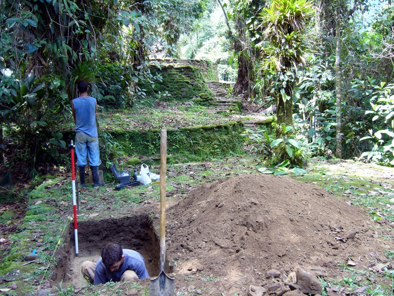
Research carried out for my dissertation between 2005 and 2010 also concentrated on understanding the deeper history of places such as Teyuna-Ciudad Perdida and Pueblito.10 The radiocarbon dates secured during the 1980s suggested that Ciudad Perdida dated to the 11th century A.D., but there were no dates for Pueblito, which made it hard to understand whether places such as these had followed common or divergent trajectories. We knew that they had been abandoned sometime around the 1600s due to a combination of diseases brought in by the Spanish and cyclical warfare with them, but we knew very little about what had happened before that. In the 1960s, Henning Bischof found a particular type of pottery that differed significantly from the Tairona wares that we already knew. The people who had produced the pottery appeared to be from an earlier time period that he called Neguanje. He assigned a tentative range of A.D. 500-750 to this time period, but had no radiocarbon dates to support his hypothesis. A few years later, Wynn found these types of pottery in his own research but like Bischof was unable to date them. Subsequent research along the coast found some burials from this period but no habitation sites. It was assumed that these particular people were the predecessors of the Tairona but the data was still insufficient to establish a direct and unequivocal relationship.
Ironically but unsurprisingly, while we were carrying out the architectural and topographic survey of Pueblito near the coast we were able to locate Neguanje period structures buried deep below Tairona terraces and structures on view to visitors and archaeologists alike. They had been, so to speak, underneath our noses all this time but had gone unnoticed by previous projects. Two overlapping Neguanje period dwellings, for example, were found almost 9 feet below the surface of a Tairona period terrace at Pueblito. In subsequent excavations at Teyuna-Ciudad Perdida we found the same pattern: earlier occupations and structures buried below structures that had been on view to everyone. When I discussed these findings in 2010 with Alicia Dussán, she indicated that it was quite clear that they had not been found because of the clean and very thick layers of fill separating the occupation levels. This had led them to assume only sterile layers of fill were to be found below Tairona household floors.
This finding has allowed us to better understand the construction sequence of these places in a more nuanced and subtle fashion. Radiocarbon dates from buried occupations at both sites suggest that they were initially settled some time between A.D. 500 and A.D. 700, and grew relatively slowly up until A.D. 1100, reaching a size of about 30 acres. Core area plazas, terracing, and structures were then rapidly built some time between A.D. 1100 and A.D. 1200 and remained unchanged until A.D. 1600. That is, these areas were used and reused continuously but saw no major changes in their architectural layout. Yet both towns continued to expand after this time period, with growth concentrating mainly in residential areas. It is now clear that the Neguanje period peoples were directly related to the Tairona, and that there is a deeper time frame to the inhabitation and transformation of the northern and western side of the Sierra Nevada de Santa Marta. As exciting as this new information is, further research on these buried occupations faces serious challenges. To be able to excavate them properly we would have to dig through Tairona structures, dismounting paved floors, house foundation rings, retaining walls, and staircases. This of course is a very prickly issue because both Teyuna-Ciudad Perdida and all other archaeological sites in the Sierra Nevada de Santa Marta are considered national heritage. For the indigenous peoples of the Sierra Nevada (Ijku, Kankuamo, Kogi, and Wiwa communities), the site is a sacred place that should not be disturbed by research activities. For these reasons, further investigation of this particular time period and its relationship to how these towns grew and developed requires rethinking research design and excavation methods. With the Colombian Institute of Anthropology and History and Teyuna-Ciudad Perdida’s conservation team, we are currently assessing the use of minimally intrusive methodologies such as Ground Penetrating Radar, magnetometry and other such sub-surface mapping techniques.
_______________________________________
 Tairona circulation patterns emphasize free flowing movement. The central area terraces have numerous internal paths and adjacent, integrated sidewalks such as these that would have allowed people to move about freely between the different parts of the town. Credit Santiago Giraldo
________________________________________________
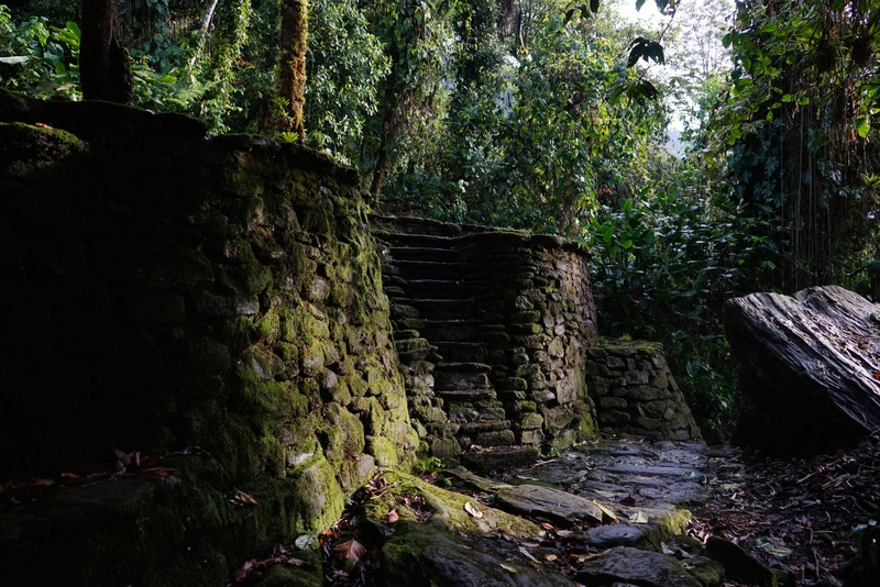 The “piedras” (stones) sector of the town has many beautifully built structures, but its main characteristic is the use of large boulders as foundation for terraces and rings. Much of the stone used to build Ciudad Perdida was quarried in this area, where laminar schist boulders such as the one on the right in the photograph can be found strewn about the slopes of the hill. Credit Santiago Giraldo
_______________________________________________
 In higher status dwellings, perfect circles of cut and dressed stone elevated above the terrace are achieved by using trapezoidal-shaped cut blocks with a curved edge. Notice also the two entrances. Masons had to work in situ to be able to assemble these rings. Credit Santiago Giraldo
_______________________________________________
 Spanish documents from the 16th century mention that Tairona family structure was polygamous. An extended family at Ciudad Perdida would have inhabited one or more interconnected terraces with various dwellings and structures such as these. This is a large terrace with two stone foundation rings. Credit Santiago Giraldo
________________________________________________
 Excavations all along Ciudad Perdida’s central sector in 2006 showed that this part of the town was built in a single push between A.D. 1100-1200. Credit Santiago Giraldo
______________________________________________
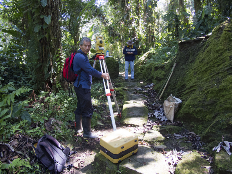 As part of the Master Management Plan and as a way of correcting a number of errors found in the 1980 map of the town, we surveyed and mapped Ciudad Perdida using total stations and set in brass benchmarks linked to Colombia’s geodetic grid. February 2011. Credit Santiago Giraldo
______________________________________________
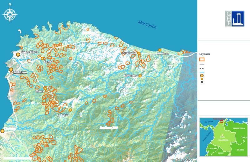 Map showing the distribution of Tairona sites located to date in the northern and western faces of the Sierra Nevada de Santa Marta. Blank areas have not been surveyed, but we know they hold numerous sites that still need to be mapped. Credit Santiago Giraldo
______________________________________________
Current Projects
In recent years (2010-2014) and in my capacity as Colombia Program Director for the Global Heritage Fund, our efforts at Teyuna-Ciudad Perdida have concentrated on solving a great number of issues and problems that emerged in the past 30 years that threatened the park’s future. In alliance with the Colombian Institute of Anthropology and History, the Colombian Park Service, the outfitters and guides, and the indigenous and peasant councils of the Buritaca Basin we have developed a number of heritage conservation, environmental, and community development projects that will hopefully ensure sustainable visitation in the foreseeable future. 11
Up until 2007, due to Colombia’s internal conflict, conservation work at the park came to a standstill. The general area was under the control of paramilitary groups and most peasant families lived off of coca production, which meant that developing any sort of project in the area was a risky endeavor. To make matters even worse, and though tourists trickled into the park even under these conditions, a kidnapping in 2003 of 8 tourists by the ELN insurgent group (Ejército de Liberación Nacional) placed the site on every country’s travel warning list. This also forced ICANH to bring down all park rangers, which made basic maintenance work a nightmare. Facilities deteriorated completely, sections of the site were overgrown with vegetation, and it was impossible to control visitation. After the 2007 demobilization agreements between the Colombian government and the paramilitary groups the situation was quite desperate and there was next to no funding available for the park. In 2009, GHF and ICANH designed a six-year project aimed at setting the park back on its feet, involving a three-pronged strategy focusing on improving management and conservation activities at the park and carrying out a number of much needed community development projects between the trailhead town and the park itself.
Between 2010 and 2012, GHF and ICANH concentrated on designing a management and conservation plan for Teyuna-Ciudad Perdida, a crucial factor that had gone unresolved since the park opened in 1981. Without the management plan, it was extremely difficult for ICANH personnel unfamiliar with the park and its history to understand long-standing problems and difficulties and thus envision strategies to resolve them. Hence, a multiplicity of projects have been developed, either to provide much needed data required for decision-making purposes or to set in motion activities suggested by the management plan. For example, the town was surveyed and mapped once again in 2011. This corrected a number of inaccuracies present in the 1980 map and gave us a Digital Elevation Model or DEM, to work with for setting up visitation circuits, buffer zones, and delimiting a protected area. Satellite imagery for the whole basin from various remote sensors was acquired, maps were updated, and we began to groundtruth the 26 sites in the vicinity of Teyuna-Ciudad Perdida. We have also begun to slowly add new sites missed during the 1980s. Each one of the structures within the area open to the public was assessed for damages and a comprehensive conservation plan was designed and set in motion. Since 2010, and for the first time since it opened to the public, conservation teams have worked every year. As I mentioned previously, research, mapping and survey work continued during 2013 at Garage 1 and 2, and B-201, sites located within the protected area delimited by the management plan.
In turn, community development projects have encompassed a wide range of activities. These have included designing new curricular materials for the trailhead school aimed at heritage and environmental conservation, wilderness first aid training for all guides, providing rescue equipment at key lodges, setting up gray and black water treatment systems for lodges, building a 90-foot-long suspension bridge at a particularly dangerous ford in the river, and building a new health post at the indigenous village of Mutanzhi. In 2012, a team of researchers from SELVA and Panthera-Colombia carried out a much needed biodiversity evaluation, aided by members of the indigenous and peasant communities. This project provided basic data needed to assess visitor impact on wildlife along the trail, thus providing baseline data allowing us to fine tune the carrying capacity assessment. Researchers also collected data on large felines with camera traps. We were able to find out that at least five puma and two jaguars, along with a healthy population of ocelots, are permanent residents along the trail. SELVA researchers also taught several workshops on bird identification and a wildlife guide for the trail was printed out and distributed at all lodges so that visitors could also learn about the incredible range of fauna along the trail.
From 2014 to 2016 we will be concentrating on expanding our mapping and survey work a bit further upriver to include a site by the name of “Tigres”. Located approximately 2.3 miles upriver, Tigres (also known as B-203 in the literature) was located in 1978 and initially mapped and investigated between 1980 and 1981. Even though it is a relatively small site of approximately 8-12 acres with some 50-60 structures, for many years now, looters have systematically targeted the site A rumor among the looters gave it its name, since a few of them claimed to have found jaguar figurines made out of gold.12 During a visit in 2010 we became aware that looters continued to “work” the site and so it was decided with ICANH that we should try and recover as much information as possible before the site was completely lost.
At Teyuna-Ciudad Perdida, Conservation activities will continue to be developed on a yearly basis according to the management plan, as well as detailed architectural mapping of each structure intervened by the team. Because the only available landing area for army helicopters to bring in provisions for soldiers stationed at the site is the 1100-1200 A.D. central platform, we would also like to be able to install vibration sensors. This will give us hard data on how landing and takeoff affect the structure. New personnel facilities are also in the process of being designed, and we hope to increase the number of park rangers from four to seven.
In sum, though much has been gained in the past four years and everyone has pitched in to solve issues and problems going back more than three decades, we still have much to do. Then again, there is still much to be learned about the Tairona.
_________________________________________________
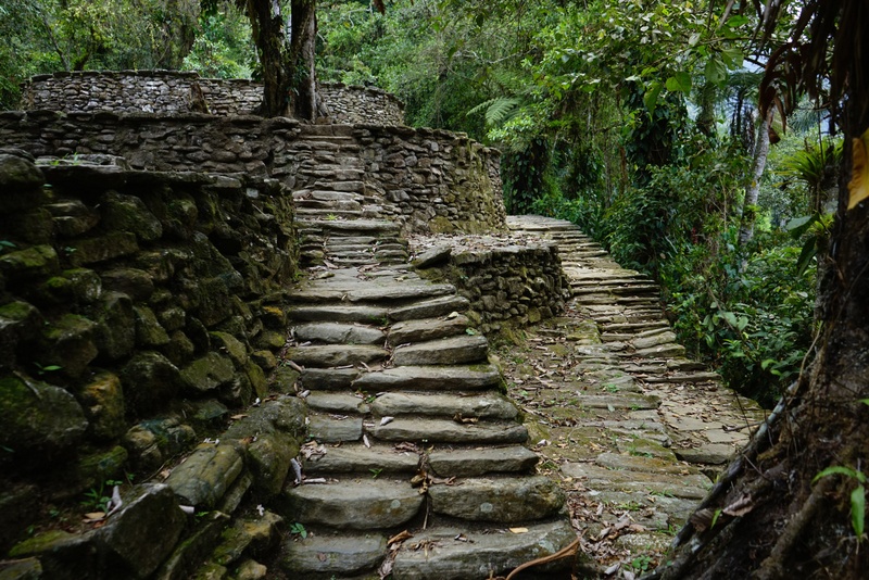
 Due to the extremely heavy rainfall in and around Ciudad Perdida (over 157 inches per year), as well as tourist visitation, the staircase leading in to the site needed to be restored early this year. All conservation activities are part of a Master Conservation Plan designed by Ciudad Perdida’s head conservator, Ms. Catalina Bateman. The basic crew is headed by Walter Hinojosa, conservation supervisor. January 2014. Credit Santiago Giraldo
______________________________________________________
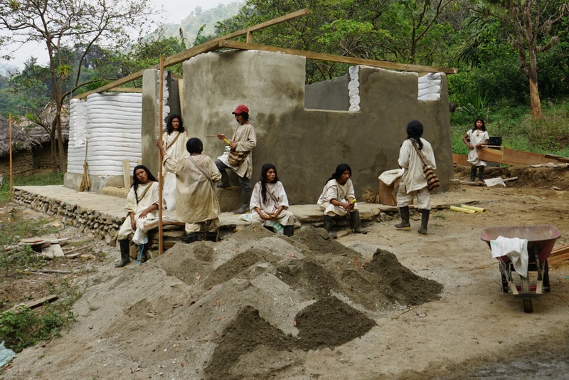 Community development in the area encompasses a wide range of activities that I co-design with indigenous and peasant leaders after extensive discussions. In late 2012 we agreed with the indigenous authorities that a new Health Post was needed at the Kogi village of Mutanzhi, on the trail to Ciudad Perdida. Throughout 2013 Global Heritage Fund raised funds from various sources, and construction began in March of 2014. The health center is being built using superadobe, a stabilized soil building technique that minimizes the use of cement and brick and provides great formal flexibility. The indigenous community has provided labor and materials such as wood, sand, stone, and soil. Here we can see the indigenous crew taking a break after hauling sand. May 2014. Credit Santiago Giraldo
__________________________________________________
Individuals interested in learning more about Ciudad Perdida and/or contributing to the efforts at the site may go to the Global Heritage Fund website for more details.
*The park currently receives about 8500 visitors per year. Any good guidebook to South America has instructions on how to get to the site and contact information for the different outfitters. Also, the 2009 English edition of the Teyuna-Ciudad Perdida Guidebook is freely available at ICANH’s website.
References and relevant bibliography
Bahn, Paul, Richard Luckyn, and Patrick Jacquelin. 1973. “Cambridge Expedition to Santa Marta, Colombia Summer 1973.” Unpublished expedition report. Cambridge.
Bischof, Henning. 1961. News Report from Bischof: Colombia. In Katunob 2(3):41-45 Magnolia
—–1969a. Contribuciones a la cronología de la cultura Tairona Sierra Nevada de Santa Marta. In Proceedings of the 38th International Congress of Americanists. pp.259-269.
—–1969b. La Cultura Tairona en el Area Intermedio. In Proceedings of the 38th International Congress of Americanists. pp. 271-280.
Cadavid, Gilberto, and Luisa F. Herrera. 1985. “Manifestaciones Culturales En El Area Tairona.” Informes Antropológicos 1: 5–54. Bogota: Instituto Colombiano de Antropología
Dever, Alejandro. 2007. Social and Economic Development of a Specialized Community in Chengue, Parque Tairona, Colombia. Unpublished PhD dissertation, University of Pittsburgh
Giraldo, Santiago. 2010. “Lords of the Snowy Ranges: Politics, Place, and Landscape Transformation in Two Tairona Towns in the Sierra Nevada de Santa Marta, Colombia”. Unpublished PhD dissertation. Chicago: University of Chicago.
—–2009. Teyuna-Ciudad Perdida Guidebook. Bogotá: Instituto Colombiano de Antropología e Historia.
Groot de Mahecha, Ana María. 1985. Arqueología y Conservación de la localidad precolombina de Buritaca 200 en la Sierra Nevada de Santa Marta. Informes Antropológicos 1. 55-102. Bogotá: Instituto Colombiano de Antropología.
Herrera, Luisa Fernanda. 2013. “El Hallazgo de Ciudad Perdida.” Unpublished document
—–1984a. “Agricultural Activity in the Sierra Nevada de Santa Marta (Colombia): Historical Perspective.” In La Sierra Nevada de Santa Marta (Colombia) Transecto Buritaca la Cumbre, Thomas van der Hammen and Pedro M. Ruiz, Eds, 501–30. Berlin-Stuttgart: J.Cramer.
—–1984b. “Buritaca 200: Survey of the Archaeology and a Palynological Investigation.” In La Sierra Nevada de Santa Marta (Colombia) Transecto Buritaca la Cumbre, Thomas van der Hammen and Pedro M. Ruiz, Eds, 531–46. Berlin and Stuttgart: J.Cramer.
Mason, John Alden. 1931. Archaeology of Santa Marta, Colombia: The Tairona Culture: Marshall Field Archaeological Expedition to Colombia, 1922-23. Field Museum of Natural History. Anthropological Series 304, 358, 446. Vol. XX, no. 1-3. Chicago.
Mason, Gregory. 1938. “The Culture of the Taironas”. Unpublished Dissertation, University of Southern California.
Reichel-Dolmatoff, Gerardo. 1951. Datos historico-culturales sobre las tribus de la antigua Gobernación de Santa Marta. Santafé de Bogotá: Imprenta del Banco de la República.
—–1953. Contactos y cambios culturales en la Sierra Nevada de Santa Marta. In Revista Colombiana de Antropología, 1 (1): 15-122.
—–1954a. Investigaciones Arqueológicas en la Sierra Nevada de Santa . Marta. Partes 1-2. Revista Colombiana de Antropología 2(2): 147-106.
1954b. Investigaciones Arqueológicas en la Sierra Nevada de Santa Marta. Parte 3. Revista Colombiana de Antropología 3: 141-170.
—–1954c. A Preliminary Study of Space and Time Perspective in Northern Colombia. American Antiquity, 4: 352-66.
Simons, F.A.A. 1879. Notes on the Topography of the Sierra Nevada de Santa Marta. Proceedings of the Royal Geographical Society and Monthly Record of Geography 1, 11 (Nov): 689-694.
_____. 1881. On the Sierra Nevada de Santa Marta and Its Watershed (State of Magdalena, U.S. of Colombia). Proceedings of the Royal Geographical Society and Monthly Record of Geography 3, 12 (Dec): 705-723.
Soto, Alvaro. 1988. La Ciudad Perdida de Los Tayrona. Bogotá: Neotrópico.
Wynn, Jack. 1974. Buritaca Ceramic Chronology: a seriation from the Tairona Area, Colombia. Unpublished PhD Dissertation, University of Missouri.
_____________________________________
Footnotes
[1] Simons 1881, 722.
[2] A simple web search for Tairona gold work will throw thousands of images. Almost a full third of the Gold Museum´s collection (34,000 pieces) is comprised of Tairona gold artifacts.
[3] Mason, John Alden. 1931. Archaeology of Santa Marta, Colombia: The Tairona Culture: Marshall Field Archaeological Expedition to Colombia, 1922-23. Field Museum of Natural History. Anthropological Series 304, 358, 446. Vol. XX, no. 1-3. Chicago.;
Mason, Gregory. 1938. “The Culture of the Taironas”. Unpublished Dissertation, University of Southern California.
Reichel-Dolmatoff, Gerardo. 1951. Datos historico-culturales sobre las tribus de la antigua Gobernación de Santa Marta. Santafé de Bogotá: Imprenta del Banco de la República.; 1951. Contactos y cambios culturales en la Sierra Nevada de Santa Marta. In Revista Colombiana de Antropología, 1 (1): 15-122. ; 1954a. Investigaciones Arqueológicas en la Sierra Nevada de Santa . Marta. Partes 1-2. Revista Colombiana de Antropología 2(2): 147-106. ; 1954b. Investigaciones Arqueológicas en la Sierra Nevada de Santa Marta. Parte 3. Revista Colombiana de Antropología 3: 141-170. 1954c. A Preliminary Study of Space and Time Perspective in Northern Colombia. American Antiquity, 4: 352-66.
Bischof, Henning. 1961. News Report from Bischof: Colombia. In Katunob 2(3):41-45 Magnolia
1969a. Contribuciones a la cronología de la cultura Tairona Sierra Nevada de Santa Marta. In Proceedings of the 38th International Congress of Americanists. pp.259-269. 1969b. La Cultura Tairona en el Area Intermedio. In Proceedings of the 38th International Congress of Americanists. pp. 271-280.
[4] Cadavid, Gilberto, and Luisa F. Herrera. 1985. “Manifestaciones Culturales En El Area Tairona.” Informes Antropológicos 1: 5–54.
[5] Bahn, Paul, Richard Luckyn, and Patrick Jacquelin. 1973. “Cambridge Expedition to Santa Marta, Colombia Summer 1973.”
[6] Based on further archaeological evidence from river basins east of the Buritaca and other unexplored areas, both Luisa and I agree that there are more than the 260 Tairona sites located to date. If the same settlement densities hold for the other basins, the total number of Tairona towns and villages probably exceeds 500.
[7] Herrera, Luisa Fernanda. 2013. “El Hallazgo de Ciudad Perdida.” Unpublished document.
[8] An account of the Ciudad Perdida project can be found in Soto Holguín, Alvaro. 1988. La ciudad perdida de los tayrona. Bogotá: Neotrópico. About 98% of the academic literature on Ciudad Perdida is in Spanish. All unpublished excavation reports can be found at ICANH’s library in Bogotá.
[9] The upper section of the Buritaca River was completely uninhabited up until about the early 1960s when homesteaders slowly began moving up the river and indigenous Kogi families moved in from the Don Diego River towards the east. The Kogi village of Mutanzhi, which lies on the trail to Teyuna-Ciudad Perdida, is actually quite recent and dates to 1986.
[10] Giraldo, Santiago. 2010. “Lords of the Snowy Ranges: Politics, Place, and Landscape Transformation in Two Tairona Towns in the Sierra Nevada de Santa Marta, Colombia”. Chicago: University of Chicago.
[11] The project has been successful thanks to the generous support of a great many donors and agencies such as CitiFoundation, Morgan Family Foundation, Fondo Patrimonio Natural (Colombia)- USAID Conservation Landscapes Program, Fundación Bolívar-Davivienda (Colombia), and private donors in Colombia, the United States, and Europe. Allied foundations such as OPePA (Colombia), SELVA (Colombia), Panthera-Colombia, and Fundación Puentes de la Esperanza (Colombia) have all contributed with expertise and in-kind support as well. Without the unwavering commitment of the guides, Kogi indigenous community of Mutanzhi, and the campesino community, none of these activities would have been possible. ICANH has consistently sought to increase the park’s budget in the past four years and provided substantial conservation co-funding.
[12] In the Sierra, jaguars are usually called “tigres” (tigers) by the indigenous and peasant population rather than jaguares.


