
PROCEEDINGS OF THE NATIONAL ACADEMY OF SCIENCES—Researchers report* that a combination of historical aerial imagery and modern airborne laser scanning (ALS) helped locate and contextualize archaeological features at risk of destruction in the ancient Jordanian city of Jerash. Rapid development of cities in the Middle East can endanger archaeological sites, which are abundant in the region and susceptible to irreversible damage that could hamper understanding of how ancient societies responded to economic or environmental change. David Stott and colleagues used historical aerial imagery of the city of Jerash in Jordan dating back to 1917 as well as modern ALS data to establish the locations of archaeological structures. Specifically, the authors used historical imagery to identify likely sites and structures and ALS imagery to assess structures remaining in the wake of development in the eastern half of the city. The authors report a substantial number of previously unmapped possible structures and refine the position of the city’s walls and the scale of previously identified structures, compared with earlier maps. The combined ALS and historical imagery suggests connections between aqueducts, cisterns, and siphons that provide insight into the structure of the water supply system for the ancient city. According to the authors, similar historical and modern remote sensing methods can help uncover and evaluate archaeological data.
________________________________
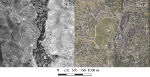
These are aerial photographs from 1953 (left) and 2015 (right) showing rapid growth in Jerash, particularly in the eastern part of the city and much of its immediate surroundings. PNAS
________________________________
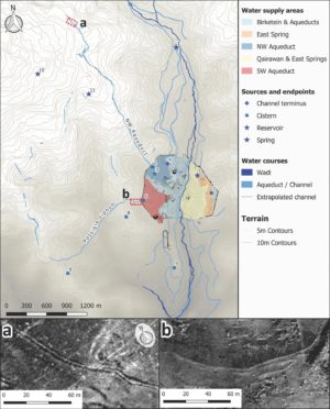
These are elements of water infrastructure mapped in this study, showing likely aqueducts, channels, springs and cisterns in relation to possible areas of supply within the city. PNAS
________________________________
Article Source: A PNAS news release
*”Mapping an ancient city with a century of remotely sensed data,” by David Stott, Søren Kristiansen, Achim Lichtenberger, and Rubina Raja.


