
The island of Britain and its associated smaller offshoots (around 1,000 islands in all and with 11,000 miles of coastline) have a history of human settlement going back to the early dawn of humanity. Repeated settlement and abandonment of Britain as the ice sheets waxed and waned over nearly a million years has been followed by continuous settlement for at least 12,000 years and possibly 16,000 years. Britain has sometimes been an island, and sometimes an extension of the northern European plain, inundated between 8,400 and 8,000 years ago to become today’s modern North Sea. The archaeological record is rich and reveals a constantly changing set of cultures, slowly becoming the modern Britain we know today. Indeed, archaeological study of these remains includes the study of contemporary material culture as much as it does that of the distant past.
The British Isles have been known as such for nearly 2,000 years, since early Roman times. Early geographers included Ireland as part of the Isles, but Ireland has long since been separate with its own rich, but very different, series of human cultures. Here, I will only deal with Britain.
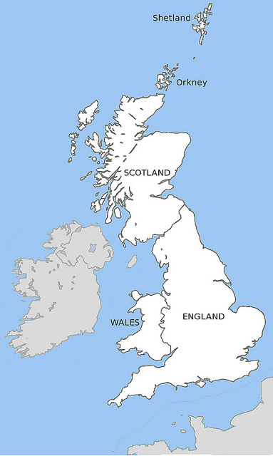
Britain and its extension to the north in the Shetland Islands to its southern most set of islands in the Scillies extends from latitude 60º 51′ N to 49º 53′ N. This is equivalent to stretching from the Ungava Peninsula to the middle of Newfoundland in Canada. As offshore islands, they currently have a maritime climate, bathed in the warming waters of the Gulf Stream crossing the Atlantic Ocean from the Caribbean. Its winters and summers are generally mild. The mainland of Britain extends for 600 miles from Caithness in the north to Cornwall in the south. Its widest point is the far south, 350 miles from Cornwall to Kent, while much of the middle and north of Britain is only 150 miles wide. It easternmost point is Lowestoft in England at longitude 1º 46′ E and its westernmost is at Ardnamurchan in Scotland at longitude 6º 14′ W, with the island of St. Kilda lying farther west at 8º 38′ W. It is currently separated from the rest of Europe by the English Channel (20 miles wide at it narrowest point) and the 350-mile-wide North Sea.
Within Britain, there is an unparalleled variety of geology, landscape and weather. Britain can be divided into upland and lowland zones, which have shaped much of its prehistory and history. The north and west are generally formed of older, harder rocks once folded into high mountains and now eroded in highland landscapes. These areas benefit from the moist warm air of the westerly weather and are ideal pastoral farming lands, with highly indented coastlines where travel by sea was often easier and faster than travel by land. The south and east are formed of younger rocks, less affected by great earth movements, forming lower lying downland and plains, with a dryer climate suitable for the growing of cereals as well as the keeping of livestock. This south-eastern lowland is the side that faces the rest of Europe, and is well placed for trade but also more likely to face the problems of defence against invaders. Within this broad distinction, there are smaller regions, each with their own characteristics and histories, such as the Thames estuary, the south-west peninsula of England, Wales and the marches, the long Pennine mountain chain, the mountainous Lake District, the Borders that cross northern England and southern Scotland, the low-lying Scottish central belt, the Highlands and north-east Scotland.
 Modern Britain consists of three nations: England, Scotland and Wales. Each has existed for more than a thousand years. England and Scotland have their origins as kingdoms under royal houses descended from foreign migrants during the 9th and 10th centuries AD. The English came as Anglo-Saxons from the coastal areas of the Netherlands, Germany and Denmark in the 5th and 6th centuries to rule over and merge with the native Britons. Likewise, the Scots came at the same time as migrants from Ireland to take over and dominate the Britons and Picts of the far north. The Britons, who were left as free and independent, formed the indigenous kingdoms of Wales. All three have been united under the same crown since 1603, yet still retain their own cultural identities and histories. Before the creation of this threefold division, we can only speak of one Britain, leaving to archaeology the task of teasing out the connections between its parts during its long prehistory.
Key archaeological sites
The earliest evidence of human occupation in Britain is on the coast at Happisburgh (in Norfolk, England). Not only are there stone tools left behind, but also precious, rare footprints left in mud by a once flowing river between 970,000 and 814,000 years ago. The humans were probably of the species Homo antecessor, an early descendant of the first humans to leave Africa. These remains belong to the Palaeolithic, or Old Stone Age. This early period of the human past lasted until the end of the Ice Age and among its more evocative sites is the gorge with associated caves at Creswell Crags (on the Derbyshire/Nottinghamshire border in England). On either side of a stream lie cliffs of limestone in which there is a series of caves with evidence for human settlement from the Middle and Upper Palaeolithic, left by both Neanderthals and modern humans as far back as 60,000 years ago. Modern people, Homo sapiens, seem to have replaced Neanderthals in Britain by about 36,000 years ago. The chief claim to fame of the caves is the presence of the most northerly Palaeolithic in the world, images of animals scratched into the cave walls, along with a possible masked human figure and a wonderful horse head, both engraved on animal bones. The art probably dates to around 14,000 years ago, towards the end of the last Ice Age, belonging to a people who hunted horses as one of their main sources of food. This is ironic, given modern Britons’ aversion to eating horse today.
___________________________________________
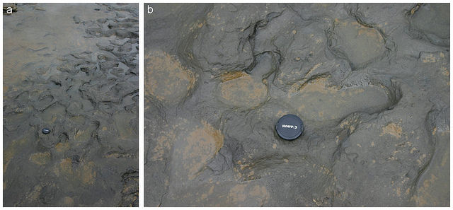 The footprints at Happisburgh
_______________________________________________________
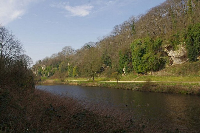 A view of Creswell Crags
______________________________________________________
One of the earliest, and best, sites of human occupation after the end of the Ice Age is the Mesolithic (Middle Stone Age) site of Star Carr (in North Yorkshire, England). Preserved in peat that was once a lake are many artefacts of bone, wood and antler, materials that do not normally survive on prehistoric sites. Among them were 21 red deer head-dresses, used probably in ceremonies designed to ensure the success of future hunts or as the coming of age of newly adult hunters. There are many special features of Star Carr beside the head-dresses, such as the oldest built structure in Britain and the earliest evidence for carpentry in Europe. The people who lived here 11,000 years ago were among the direct ancestors of modern Britons, and represent a time when people lived in close relationship with the landscape and its plants and animals. There are few (if any) truly natural environments in Britain today. To recover a sense of wild Britain and our proper place in it, we have to journey back in time to the Mesolithic, a world that was lost with the advent of farming 6,000 years ago.
The first farmers left behind an Early Neolithic (New Stone Age) culture, where clearings were being made in the forest on a large scale and large burial mounds and gathering sites were created. The basis of Britain’s lifestyle of dependence on wheat, barley, cattle, sheep and pigs (all still the mainstay of modern farming) was being laid. One key site of this period was not, however, a farming site. The site of Great Langdale (in Cumbria, England) was a factory, producing blanks for making stone axeheads out of the very bedrock of Britain. A fine-grained volcanic tuff, the solidified ash of a long extinct volcano provided a highly prized material for making polished stone axeheads. These were traded across large areas of Britain in a network of social contacts that spanned the island from north to south and east to west. No part of Britain could consider itself alone and apart from the rest of the island. People may have had different styles of pottery, or modes of burial, and lived in different ‘tribal’ identities, but they still connected with one another and made links across the whole of Britain.
_________________________________________
 Great Langdale
____________________________________________________
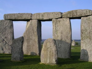
Some parts of Britain have been blessed with more favorable locations than others, whether with better soils, a better climate, better resources or with a better location for trade along rivers or the coasts. One of the earliest great centers in Britain was the Wessex Downs, whose greatest site is the renowned Stonehenge (in Wiltshire, England), 5,000 to 3,500 years old (passing from the Late Neolithic into the Early Bronze Age). Another great center, only recently discovered and still being excavated, is the Ness of Brodgar (in Orkney, Scotland) and currently dated from 5,200 to 4,300 years ago. Each was very different, but each was a religious and ceremonial site concerned with the passing of the seasons, and probably with beliefs connecting the endless cycle of birth and death with the rebirth of the sun at mid-winter and its decline every year at mid-summer. The two areas may even have been in direct contact with each other. Britain was small enough for far-flung communities to be easily in contact, especially by sea, while it was also big enough that certain parts could thrive relative to others and be powerful political, religious or cultural centers providing distinct identities. By the end of the Early Bronze Age it seems that powerful families were accumulating wealth and power above and beyond the rest of the population. From now on, social and economic inequalities would be built into the fabric of British life.
________________________________________
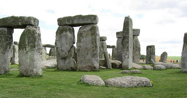 Stonehenge
______________________________________________________
Tensions between inequality and the notion of community is well seen in the sites of the Late Bronze and Iron Ages Gurness with their hill forts and farms. One particular type of site that is unique to the north of Britain is the stone-built, fortified tower known as a broch. Gurness (in Orkney, Scotland) is one of the best surviving of these. It was occupied for 300 years after 2,200 years ago. The central tower is 65 feet across and has a surrounding settlement of linked houses built also in stone that could have housed up to 40 families. The site lies on the coast commanding views of the sea. It combines functions of defense in the tower as well as display over a distance signaling the status of the inhabitants or their leaders. Along Britain’s coast have long been key sites for defence and display, natural for a sea-going island people.
_________________________________________
 Gurness
_________________________________________________________
Britain finally becomes part of history, illuminated and described by written documents and inscriptions, and having named ‘tribes’, people and settlements, with the conquest of the southern half of the island by the Roman Empire after 43 AD (more than 1,970 years ago). Attempts to conquer the whole of Britain failed and the Romans settled for a northern border between them and the Britons in the north, Hadrian’s Wall (between Northumberland and Cumberland, England). This was begun in 122 AD and after an aborted try at building a frontier farther north, the Antonine Wall (between Dunbartonshire and Falkirk, Scotland, occupied 142-158 AD), became a 73-mile long fortified frontier eventually centered along a stone-built wall connecting the North Sea and Irish Sea coasts. The whole border included 15 major forts along the wall with supply depots to the south and outlying forts to the north. The Wall symbolises a divide between a so-called civilized south and wilder, less acceptable north. Of course, this is a wholly southern perspective! The position of this psychological difference between the two extremes of Britain has changed often since then but is still a feature of a modern Britain, dominated by a prosperous southeast in contrast to the north and west.
__________________________________________
 Hadrian’s Wall
__________________________________________
The origins of modern Britain lie in the centuries after the end of Roman rule in Britain. Germanic peoples migrated to eastern Britain, eventually conquering much of the south and east to create Anglo-Saxon kingdoms. Irish migrants entered the west coast, and in the far north east created a Scottish kingdom. Native Britons remained in the northwest, west and southwest of Britain. These new kings in Britain were a warrior caste, with contacts to the rest of Europe, but forging new insular identities. The most spectacular evidence for them comes from the site of Sutton Hoo (in Suffolk, England). The burial ground here contains the resting place of a 7th century king, probably King Rædwald of the East Angles who died in 626 AD. He was placed in a 90-feet-long ship within a large mound of earth. Buried with him were many artifacts, including some of the most spectacular goldwork of the past, of a remarkably high technical and artistic standard. They represent the ultimate in ‘bling’ and symbolize the extremes of wealth and power that early Medieval kings could attract. The artifacts also came from a wide range of places on the continent and in Britain, so also symbolize the interdependence of the royal elites and how wealth comes from looking outwards as much as from power over one state.
__________________________________________
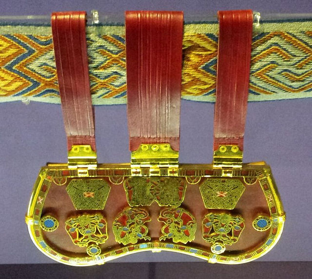 Artifacts found at Sutton Hoo reflected fine craftsmanship and were testaments to the wealth and power of some Anglo-Saxon kings.
_______________________________________________________
The creation of larger and more powerful kingdoms of England and Scotland was based on the work of particular 9th century kings like Alfred the Great of Wessex (in England) and Kenneth MacAlpin of Dal Riada (in Scotland) and completed by the mid-10th century. These together with the smaller Welsh kingdoms were fully Christian, able to withstand and absorb the heathen Vikings who attacked and settled in Britain during these centuries. They developed societies and cultures that far surpassed the achievements of Rome. Britain’s towns, villages and landscapes took shape in the Medieval centuries that followed. Castles, manor houses, churches, cathedrals and monasteries became major architectural marvels of their day. They were also centers of great wealth, based on farming. Much of England’s great wealth at this time came from the sale of wool and cloth to the continent. The great monasteries played a key role in creating such wealth, and one of the most poignant of these is Fountains Abbey (in North Yorkshire, England), founded in 1132. It is poignant because the religious reformation of the 16th century swept it away along with all other monasteries, leaving it an impressive and picturesque ruin today.
_________________________________________
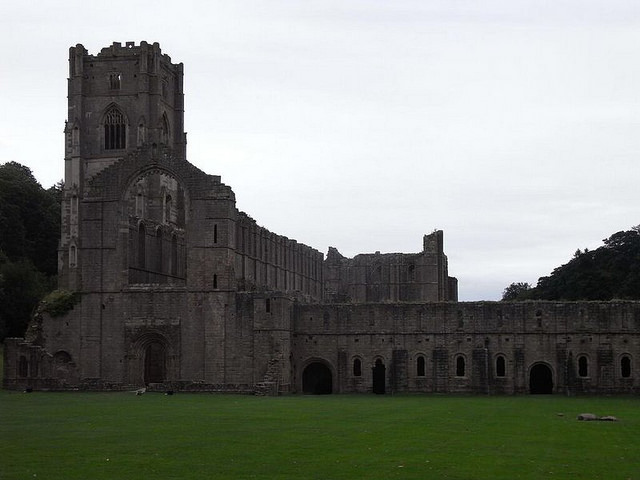 The ruins of Fountains Abbey
_____________________________________________________
The Reformation ushered in the modern age in both England and Scotland. This was an age of enlightenment, dominated by a prosperous middle class of merchants and rural gentry and serviced by scientists and philosophers. The city of Edinburgh (capital of Scotland) is a supreme symbol of this modernism. The building of the royal palace at Holyrood in 1498 led to the redevelopment of the street between it and the castle with its closely packed tenement buildings for the new urban population. Scotland was at the forefront of the new intellectual enlightenment in the 18th century and the new spirit of rational application of science was applied to town planning. Rather than sweep away the now crowded tenements in the Edinburgh, a new, planned town was created from 1767 onwards. This Edinburgh New Town was built to a classical architectural style, symbolizing the rationality of the time and forms a breathtaking contrast to the Old Town next door. Edinburgh symbolizes the growth of the new out of the old, keeping past and present together, yet achieving a freshness and beauty out of the contrast. Britain is both old and new, constantly reinventing itself.
________________________________________
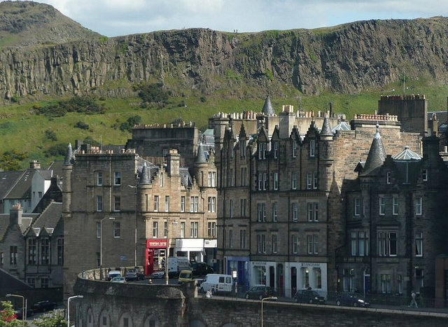 A view of Edinburgh
_____________________________________________________
Modern Britain was the birthplace of the Industrial Revolution, which created the world we now live in. One of the best representatives of the revolution is the World Heritage Site of Blaenafon (in Gwent, Wales). The site began as an ironworks in 1788 with an added coal mine in 1860. Industrial production ended in 1980 and the site now stands as an epitaph to Britain’s industrial past and symbol of its post-industrial status. It also reminds us that Wales, so long seen as a marginal part of Britain, was for part of its history a central part of the world economy. Blaenafon became a complex of mines, quarries, canals, railways and workers’ housing, including the world’s first railway viaduct built in 1790. The remains of industry are as much a subject for archaeology as any prehistoric site, and much richer in their symbolism of the hard work of the many ordinary people who provided the wealth for the richer or more powerful few who are usually remembered in most accounts of our past. Britain has come a long way since those first footsteps in the mud around 900,000 years earlier.
________________________________________
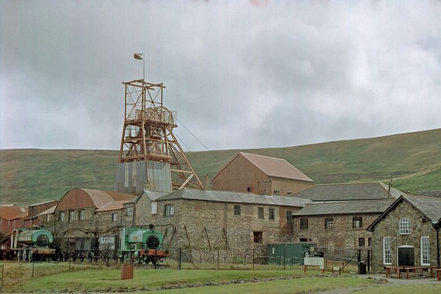 Blaenafon
____________________________________________________
Taking the long view
Looking back on Britain’s past, what does it tell us? Can we see any patterns, anything that could help us make sense of the world we live in today?
One thing that stands out is the importance of the physical environment in which people lived, on the political relations between different parts of the island and on the economy of trade, agriculture and industry. First the fast-flowing rivers in the uplands, then the coal fields of central Scotland, northern England, the English midlands and south Wales determined the creation of the world’s first industrial revolution and brought wealth to previously marginal parts of Britain. The extensive coast and river systems, and later also the canals were the main arteries of transport within Britain but also between Britain and its neighbors (both for trade, migration and war). The variety of rocks, landscapes and climates in Britain creates regions with clear identities, yet still tied together in both rivalry and dependency.
Over time, there have been strong changes in this geography. Britain has not always been an island and its connections with the rest of Europe are often underestimated. The modern island mentality is curiously at odds with the constant flow of people and ideas between Britain and the continent over thousands of years; from its resettlement after the Ice Age, the coming of agriculture in the Neolithic, the development of Celtic languages and peoples during the Iron Age or earlier, the Roman conquest, migration and conquest by Anglo-Saxons and Scots, Viking raids and settlement, Norman conquest, protestant refugees in the 16th and 17th centuries to the influx from the former Empire in the 20th century. All have left traces in Britain’s archaeology.
Changes in climate over this time have also had important effects. The drowning of the land bridge to Europe by rising sea levels as climate warmed after the Ice Age is the greatest of these. Warming and cooling at different times since then have affected how we gain our food from the land, the ebb and flow of farming into and out of marginal uplands and the ability of powerful elites to support themselves on agricultural surpluses. Deserted villages and farms all over Britain are testimony to the changes wrought by climate, landlords and local people at different times in our past.
Different parts of Britain have been important political, economic or religious centers at different times. Currently it is London and the southeast that dominates the island economy. In previous times this was not so. Argyll, Tayside, Edinburgh and Glasgow have at different times dominated Scotland in historic times. Orkney seems to have been especially important during prehistory. In England, dominance has fallen to the industrial areas either side of the Pennines and the midlands, the rich medieval farmlands of East Anglia, the powerful Kingdom of Wessex in the south, and the prehistoric splendors of central chalk downs. Wales has swung between domination by Gwynedd in the north to the industrial valleys of the south. Nothing lasts forever, and centers today may be on the margins tomorrow. For the archaeologist this leaves a rich landscape of remains and sites from all periods not yet destroyed by ‘redevelopment’.
Britain then is a diverse island, both spatially and over time. Its cultural diversity continues to grow and change. Its remains continue to delight and baffle in equal measure as archaeologists seek to uncover its rich island story. What they reveal is an island at times a cultural backwater, at other times a world center. The story of Britain is endlessly fascinating; a story of varied and mixed identities, or different peoples living together and overcoming dreary and disastrous wars to live together in peace, and while absorbing later newcomers, all descended ultimately from those intrepid colonists who migrated north and west into Britain as the ice sheets retreated and opened up a new land on the edge of Europe.
_________________________________________
You can read more about Britain’s archaeology in Donald Henson’s new book, Archaeology Hotspot Great Britain: Unearthing the Past for Armchair Archaeologists
_________________________________________
All images provided courtesy of Donald Henson


