American Association for the Advancement of Science (AAAS)—Scientists have uncovered traces of an expansive fish-trapping network created by ancient Mesoamericans in what is now modern-day Belize. Located in an incredibly biodiverse wetland, this extensive system provided Archaic hunter-gatherer-fishers with significant food and likely supported the rise of Mayan civilization in the following Formative period. Belize’s Crooked Tree Wildlife Sanctuary (CTWS) has a 10,000-year-long record of human occupation that began in the Archaic Period around 8000 BCE to 1800 BCE and included the Formative Period from 1800 BCE to 150 CE. Using drones and Google Earth imagery, Eleanor Harrison-Buck and colleagues discovered an ancient and vast network of earthen channels used by ancient Mesoamericans for fish trapping. They also excavated 3 of these channels for radiocarbon dating. Evidence indicated that Archaic and Late Archaic hunter-gatherer-fishers built this network, which were subsequently used by the Maya to harvest fish. Notably, these channels predate similar ones in Amazonia by 1,000 years. Harrison-Buck et al. saw signs of a centuries-long drought in excavated sediment samples that started in 2200 BCE. They argue that the drought might have shifted societal focus from maize-based agriculture to aquatic food production. They calculate that the CTWS network could have yielded enough fish to feed around 15,000 people annually. “To be clear, we are not claiming that 15,000 people were congregating at any one time in the CTWS during the Late Archaic. However, there is evidence for such population growth in the Maya area by Middle to Late Formative times,” the authors note. “Fisheries were more than capable of supporting year-round sedentarism and the emergence of complex society characteristic of Pre-Columbian Maya civilization in this area.”
_______________________

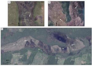
Seasonal floodplain landscapes with earthen fish weirs that resemble those in the CTWS. Satellite imagery includes (A) a contemporary fishery in Zambia, Africa; (B) an ancient fishery in the Bolivian Amazon; and (C) the ancient fishery in the Western Lagoon, CT WS, Belize (all images courtesy of Google Earth). All images courtesy of Google Earth. Harrison-Buck et al., Sci. Adv. 10, eadq1444
_______________________
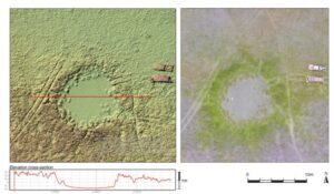
Digital Elevation Model (DEM) of a pond feature in the Western Lagoon. Harrison-Buck et al., Sci. Adv. 10, eadq1444 (2024)
_______________________
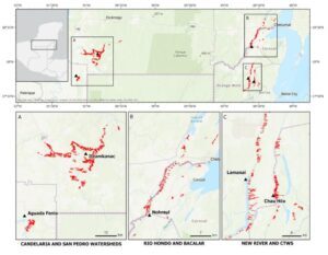
Linear wetland features identified in remote sensing data as probable fish-trapping facilities from areas across the Maya Lowlands. An overview map (top) with inset maps below showing linear channels identified in (A) the Candelaria and neighboring San Pedro Drainage, (B) the Rio Hondo and Bacalar, and (C) the New River and Western Lagoon in the CT WS (all images courtesy of the BREA project). All images courtesy of the BREA project. Harrison-Buck et al., Sci. Adv. 10, eadq1444 (2024)
_______________________
Article Source: AAAS news release.
*Late Archaic Large-Scale Fisheries in the Wetlands of the Pre-Columbian Maya Lowlands, Science Advances, 22-Nov-2024. 10.1126/sciadv.adq1444
_______________________
Advertisement
EXPLORE THE ANCIENT ETRUSCANS IN PERSON!
Experience a unique, up-close-and-personal hike among ancient hilltop towns in central Italy. You will walk the sensational countryside of the regions of Umbria and Tuscany, soaking in important sites attesting to the advanced Etruscan civilization, forerunners of the ancient Romans; imposing architectural and cultural remains of Medieval Italy; local food and drink; and perhaps best of all — spectacular scenic views! Join us in this collaborative event for the trip of a lifetime!

