For millennia, Troy was Western culture’s lost ideal of longing: a city steeped in legend and severely punished by fate, submerged in floodplain deposits near the Dardanelles in northwestern Turkey. It was supposedly discovered there in 1868 by the German merchant Heinrich Schliemann during a flying visit. Schliemann apparently had not even visited the site at the time; instead, he was persuaded by his dinner host Frank Calvert to dig for Troy on the hill called Hisarlık. Schliemann had invited himself to the diplomat’s house after he had missed his ferry to Constantinople. At Calvert’s place, he saw the bulging glass cases filled with Bronze Age finds that his host, an amateur researcher, had excavated in the region. Schliemann thus found the destiny for which he had been searching so longingly – for wealth he already possessed enough.
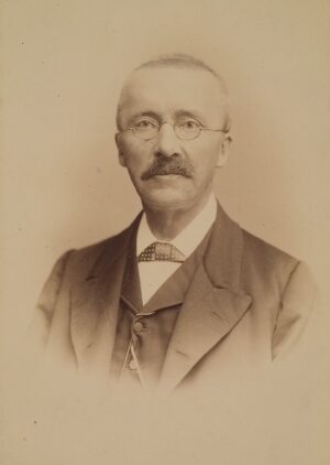
Heinrich Schliemann. Ed. Schultze Hofphotograph, HeidlCON, Creative Commons Attribution-Share Alike 4.0 International, Wikimedia Commons
A recently published scientific study* argues that Troy was not an isolated outpost on the wrong – non-European – side of the Aegean Sea. Instead, the study claims, the city was embedded in a long-lasting and influential culture, which, however, has hardly been investigated so far. An international team of archaeologists, geoarchaeologists and experts in geographic information systems (GISs) spent a full twelve years combing through the almost exclusively Turkish archaeological literature to find out which settlements from Troy’s heyday in the second millennium BCE are already known today. For this purpose, 33 archaeological excavations in western Turkey were recorded and evaluated, as far as they touched the Late Bronze Age (ca. 1700–1200 BCE). The results of 30 archaeological surveys in an area equivalent to twice the size of Ireland were also evaluated. This has resulted in a catalog of 477 settlements known today, all of which are more than 100 meters in diameter. For each of these 477 sites, 30 physio-geographical parameters were determined to perform quantitative analyses with the help of GIS. The research confirms the existence of the Luwian culture, already postulated in 2016 in a preliminary publication, a culture that until today is not indicated on maps. In addition, the study allows quantifiable statements about site selection and economic practices at that time.
________________________________
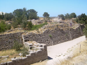
The walls of the acropolis of Troy VII, the site of the Trojan War. CherryX, Creative Commons Attribution-Share Alike 3.0 Unported, Wikimedia Commons
________________________________
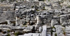
Tower remains at Troy. Leon Petrosyan, Creative Commons Attribution-Share Alike 4.0 International, Wikimedia Commons
________________________________
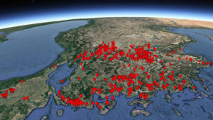
Almost 500 large settlement sites in western Asia Minor dating to the second millennium BCE have been catalogued (Luwian Studies #0120).
________________________________
Euro-Centric Biases
Schliemann’s spectacular success at Troy fundamentally changed archaeology. Not only was he able to prove that Troy was not a figment of the poet Homer’s imagination, but his excavations also demonstrated the existence of a sophisticated culture a thousand or even two thousand years before classical antiquity. The time of the great discoveries in archaeology, however, between about 1870 and 1930, was also marked by prevailing political attitudes, which from today’s point of view are extreme and no longer comprehensible. Colonialism led to the exploitation of foreign peoples. With a cultural divide between the supposedly superior Leitkultur (leading culture) of the West and the so-called primitive peoples of the Third World, scholars tried to justify the exploitation with supposed scientific arguments. Particularly serious was the conflict between Europe and the disintegrating Ottoman Empire, which eventually culminated in a bloody war with Greece. Schliemann himself, after his spectacular successes, could choose which sites to focus his attention on. He chose Greece, where the New Humanists and Philhellenes saw the cradle of European civilization. The Anatolian shore of the Aegean Sea also became the target of archaeological excavations, such as those begun in 1878 at Pergamon, in 1895 at Ephesus, in 1899 at Miletus, in 1904 at Aphrodisias, and in 1910 at Sardis – all thriving metropolises in classical antiquity, a time when life in western Asia Minor was European in character. Schliemann’s discovery of the Bronze Age also ensured that other protohistoric sites were searched for in the vicinity of Troy, i.e. in the west of present-day Turkey. The study that has now been published therefore benefited from many previous extensive surveys.
To this day, according to archaeological textbooks and an extensive popular scientific literature, the period of Troy’s greatest flowering in the thirteenth century BCE was framed primarily by two centers of power in the northeastern Mediterranean: the Mycenaean culture in the south of present-day Greece, fragmented into a few dozen petty kingdoms, and, the centrally governed Hittite culture in central Asia Minor. The area in between, the west of present-day Turkey, remained a kind of desert in terms of archaeological excavation of Bronze Age sites – even though Troy is located in this region and it is where most Greek thinkers before Socrates lived. The 477 flourishing settlements from the period between 2000 and 1000 BCE now identified provide evidence that this blank spot on the map of cultures should be filled. The Luwian language, which was widespread throughout western and southern Anatolia at the time, may have been identity-forming for the people who lived there. The third great script of the Bronze Age (in addition to cuneiform and Egyptian hieroglyphs) also originated in this region; the picturesque Luwian hieroglyphs remained in use for over 1,300 years. It therefore makes sense to call the people who lived between the Mycenaean realm in the west and the Hittite kingdom in the east the “Luwians.”
__________________________________
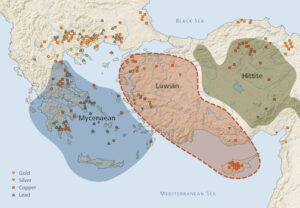
The realms of the Mycenaean and Hittite cultures were defined more than a century ago. This map shows the Luwian sphere of influence in western Asia Minor and also indicates ore deposits. (Luwian Studies #0109).
__________________________________
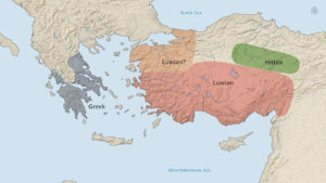
Luwian was the predominant language spoken in Anatolia during the thirteenth century BCE (after Wittke, Olshausen, and Szydlak 2007, 22; Luwian Studies #0110).
__________________________________
Advertisement

__________________________________
The Paraphernalia of Luwian Culture
What did Luwian culture look like? First of all, there was a wide range of typical Anatolian ceramic forms. Anatolian Gray Ware was predominant in the northwest; elsewhere Anatolian Red Ware was common. There was also so-called Gold Wash Ware, named for its high mica content. The inland communities can be divided into three main categories. Over ninety percent of the settlements were rural in nature. There, peasants and artisans lived in close-knit houses highly concentrated in one place. Trade and administrative centers were located at traffic junctions and, occasionally, at strategically particularly important passages, mighty fortresses were built on hilltops. Whether their primary function was that of barracks, an arsenal or a refuge is not yet clear. In the case of the coastal villages, three further forms of communities can be distinguished. There were fishing villages with moorings for small boats that did not travel far. Blessed with natural harbors, there were port towns with sea routes to the coasts around the eastern Mediterranean. The third category was ports of call established by foreigners who sought provisions and fresh water, as well as shelter during storms, or needed to make repairs to the ships. These ports of call may have had another function: they may have shortened trade routes considerably. If it was generally known that Mycenaeans maintained a port on an Anatolian shore which was run by Greek ships, it may have sufficed to drop off commodities there instead of taking them all the way to Greece. This would have made transport shorter, safer and considerably cheaper. There is no reason to believe that claims were made from such ports of call on the territories surrounding them. On the contrary, everything indicates that hidden places without advantageous connection to the inland were deliberately chosen for such installations.
____________________________________
Anatolian Gray Ware. Carole Raddato, Creative Commons Attribution-Share Alike 2.0 Generic, Wikimedia Commons
____________________________________
Thanks to the excavations, almost all of which were carried out under the direction of Turkish archaeologists, the economy of the time is known quite well. Subsistence agriculture prevailed almost everywhere; accordingly, peasant families lived from what they cultivated. To acquire items beyond the needs of daily life, having a commodity that could be produced locally in surplus was crucial. This could be ores, for example, which were abundant in western Turkey. The legendary King Midas, in whose hands everything turned to gold (according to myth), ruled in this region. King Croesus, the proverbial richest man of all time, also came from there. The possession of gold, silver, copper, and lead had a function like money. Metals indicated status and could be hoarded to fall back on in uncertain times. The most important goods produced in surplus, however, appear to have been fabrics and ceramic vessels, the latter were probably filled with essences, oils or other valuable agricultural products.
_________________________________
Biconvex bronze seal with Luwian hieroglyphic inscription found at Troy (Luwian Studies
#0504).
_________________________________
Long-Distance Trade via Cyprus
A deep insight into the trans-regional flow of goods is provided by reading Cypro-Minoan documents proposed by the linguist Fred Woudhuizen. According to these, all but one document with this script found to date are of the same type: they are lists of lading recording goods in transit. The documents were found in Enkomi on Cyprus and in Ugarit in northern Syria and stem from a short period of time around 1200 BCE. They are like spreadsheets indicating first the supplier, then the recipient, then the number of products, and finally the goods, the latter in abbreviated form. The merchandise arrived mostly from northwestern Turkey, probably from the region of Troy, but Ephesus and Crete are also mentioned as producers. Registering commodities in Cyprus was crucial since the Hittite Great King levied taxes on them. Obviously, the Hittites always used the same accounting system, as it was already known from excavations in Anatolia. However, the rulers could of course not impose a foreign language or script on the local officials. On the mainland the clerks therefore used the Luwian language and Luwian hieroglyphs for their bookkeeping, while the officials on Cyprus also wrote in Luwian but in the local Cypriot script. Goods were shipped several times until they could be carried on the shortest possible land route to the Hittite capital Hattusa. Obviously the haulers preferred the sea route, presumably because it was faster and safer.
At this time, around 1200 BCE, Cyprus had been annexed by the Great King of Hatti because he had previously lost the important copper deposits of Isuwa in the east to Mitanni. Cyprus possessed copper in abundance. However, the annexation to the Hittite Empire interfered with international long-distance trade, as the cylinder seals from Enkomi clearly indicate. Having to pay taxes to the Hittite Great King must have been a thorn in the side of the merchants. The Hittite royal house was weakened by internal strife that had persisted for generations. If the patronized neighbors were interested in breaking Hittite hegemony over Central Asia Minor, the time was right. None of the neighboring states would have had a chance of defeating Hatti on their own. A military alliance, albeit a temporary one, offered the only prospect of success. Owing to the limited size of city and petty states, such coalitions were common at the time – shown, for example, by the enumeration of the vassals, mercenaries and militias on the side of the Hittite Great King at the battle of Kadesh. If anyone had a chance to topple the Hittite regime, it would have been the united countries of western Asia Minor. They suffered the most from Hittite excesses, but had also gained some strength.
A Telling Find
The only document in Cypro-Minoan writing that does not represent a list of lading testifies to what happened next. This object bears the inventory number Enkomi 1687 and is on exhibit in the Archaeological Museum in Nicosia, Cyprus. It is a letter from a Cypriot admiral – again according to Fred Woudhuizen – who is conducting a patrol in the southern Aegean on behalf of his king. At Samos, he unexpectedly encounters a large fleet. The Cypriot discovers that a certain Akamas commanded this fleet which apparently had set out from Troy. The Cypriot navarch turns away and heads for a Hittite port of call in Lycia. From there he dictates this letter to his king to request reinforcements. That such contingents were indeed sent to the region has long been known from correspondence found in Ugarit. Enkomi 1687 could thus be a smoking gun long hoped for to determine the origin and motive of the so-called Sea Peoples. These united warriors of various ethnic groups terrorizing the shores of the eastern Mediterranean around 1200 BCE evidently came for the most part from Luwian states, with the fleet apparently having assembled in Troy.
The raids of the Luwians/Sea Peoples were crowned with success. The Hittite kingdom fell and sank into oblivion for over 3,000 years. The Luwian sphere of influence thus extended for a few years from the Vardar River in northern Greece to Ashkelon on the border between Canaan and Egypt. The Mycenaean Greeks, of all people, who had not been involved in the upheavals, then decided to copy Luwian military strategy. The rulers of the petty kingdoms also formed a military alliance and ordered the building of a fleet, an undertaking that lasted a few years. Eventually, they attacked the Luwian port cities one after another. In the end, the combined forces of both sides had a showdown in the plain of Troy, where it all began. After a period of siege, the Greeks were able to capture and destroy Troy. The reason for the conflict, however, was not to avenge the taking of a woman, as is related in Homer’s mythic Iliad, but more likely control of trade routes. Ultimately, it was a matter of who would rule the world.
_______________________________
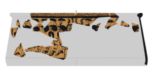
Late Bronze Age crater from Bademgediği Tepesi showing feather crown warriors in a ship; (after Mountjoy 2011; Luwian Studies #0308).
_______________________________
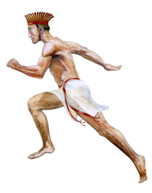
Artist’s impression of a warrior with feather crown (©Rosemary Robertson;
#4021).
_______________________________
The Greek leaders could not truly savor their victory, however, for when they returned home, civil war was raging in many places. As a consequence, in the memory of this uniquely profound cultural collapse shortly after 1200 BCE, Troy always remained the object of European admiration. For 2,500 years, Troy was considered by many to be the origin of European culture. Immigrant peoples such as the Etruscans are said to have had their origins in western Asia Minor. Hundreds of cities in Central Europe were built on the Trojan model. Aristocratic families from all over Europe traced their family trees back to Trojan noble families. Even in the late Middle Ages, up to the time of Shakespeare, books about the Trojan War were by far the most widely read secular literature. With the conquest of Constantinople in 1453 and the second siege of Vienna by the Ottoman Empire in 1683, the mindset in Europe changed completely. Since then, the importance and influence of Anatolian cultures have been deliberately downplayed. This now results in a research gap of one and a half centuries. In other words, there are probably few other regions in the world today where there is still so much yet to be discovered archaeologically as in the Bronze Age cultures in western Turkey.
________________________________
Advertisement

Don’t miss out on this unforgettable evening as Dr. Hawass reveals the most closely guarded secrets of ancient Egypt and presents his groundbreaking new discoveries and latest research live on stage. As the man behind all major discoveries in Egypt over the last few decades and director of several ongoing archaeological projects, Dr. Hawass may yet surprise you with unexpected revelations that will make news across the world.
________________________________
*Scientific Publication
Eberhard Zangger, Alper Aşınmaz and Serdal Mutlu (2022): “Middle and Late Bronze Age Western Asia Minor: A Status Report.” In: The Political Geography of Western Anatolia in the Late Bronze Age, edited by Ivo Hajnal, Eberhard Zangger, and Jorrit Kelder,
Archaeolingua Series Minor 45, 39–180. Archaeolingua, Budapest. ISBN 978-615-5766-54-1
Free download: https://luwianstudies.academia.edu/EZangger
This project was funded by Luwian Studies and by a one-year grant from the University of Zurich.
Cover Image, Top Left: Walls of ancient Troy. Ebru Sargın L., Creative Commons Attribution-Share Alike 4.0 International, Wikimedia Commons


_(cropped).jpg)
.jpg)
,_Turkey_(7446237818).jpg)