
As discussed in the first article in the Series, Early States in the Andes, there were two noticeable architectural and ritual trends emerging during the Late Preceramic (3000-1800 BCE), and into the Initial Period (1800-900 BCE). While the last article focused on the specific differences and the most well-known centers associated with these highland versus coastal “canons,” this article will expand on the geographic region, or space between, these two zones, and focus on one site in particular, the Cosma Complex, located in the upper reaches of the Nepeña Valley, Peru.
Early and contemporary scholars have long held debates about highland and coastal developments for the onset of Andean Civilization. The number of early sites clustered along the coast, paired with the complexity and monumentality of most of these centers, has often led researchers to lean toward favoring coastal origins of state development in Peru. Highland researchers, however, have argued that the quantity of early coastal sites may in fact be more representative of survey bias (many researchers focus on coastal sites due to the ease of travel and logistical planning for crews during excavation, compared to the more mountainous and hard-to-reach highlands). Distinct dividing lines were drawn within this early archaeological analysis, categorizing and classifying regions, sites and theories into “coast” vs. “highlands.” This distinction often left the geographic regions between these spaces, mostly the area comprising the western flank of the Cordillera Negra Mountains within the Department of Ancash, to be neglected by archaeologists until more recently.
Highland Sites
To recap, coastal Late Preceramic centers consisted of complexes with large pyramid mounds associated with sunken circular courts and expansive public plazas. Many of these centers included a multitude of mounds and courts, such as those found at the sites of Caral in the Norte Chico region of coastal Peru. In contrast, contemporaneous highland centers were composed of smaller, privatized chambers that included single entrance-ways, wall niches, sunken floors, and a focus on a central hearth feature. This tradition was dubbed the “Kotosh” or the “Mito” tradition, most notably named from the distinctive architectural features found at the type site of Kotosh, located in Huanuco, Peru. Kotosh-Mito structures have been found throughout the Department of Ancash and Huanuco —mainly in the highlands, at the sites of Kotosh, Shillacoto, Huaricoto, La Galgada, Piruru, el Silencio, Chavín de Huántar and Hualcayan (Bonnier 1997; Bria 2017; Burger and Burger 1985; Contreras 2010; Grieder et al. 1988; Izumi and Sono 1963; Izumi et al. 1972; Montoya 2007; Quilter 1991).
_______________________________
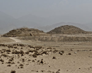
A view of the great pyramids at Caral. Dr. Kimberly Munro
_______________________________
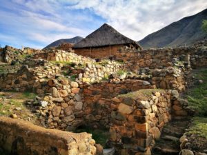
Above and below: The remains of Kotosh. Pitxiquin, Creative Commons Attribution-Share Alike 4.0 International license, Wikimedia Commons
_______________________________
Dates for these complexes range from the Late Preceramic into the Initial Period, with a few centers’ use extending into the Early Horizon (900-200 BCE). Comparatively, the quantity and megalithic features of coastal sites far outweighs the sample size recorded to date for the highlands. A number of archaeologists have interpreted this as evidence for civilization originating along the central coast, mostly in the Norte-Chico region (mainly due to the rich marine resources associated with the coastal sites, which could support large populations, cities, and more complex life-ways).
The early dates and repeated occupation at Guitarrero Cave, however, paired with new research in the highlands, and areas in between, or “border’ zones, may indicate that highland developments were equally complex and contemporaneous with the earliest monumental constructions along the coast.
______________________________
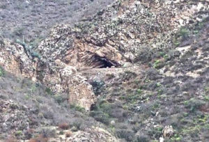
The Guitarrero Cave. Ondando. Creative Commons Attribution-Share Alike 3.0 Unported, Wikimedia Commons
______________________________
Cosma
As mentioned above, traditionally, archaeologists have focused their excavations at coastal centers and highland sites, leaving a large temporal and geographic gap for zones in between these regions. Recently, however, aerial and pedestrian surveys paired with excavations have expanded out into these outlying ‘in-between’ regions, adding to our understanding of the architectural and religious networks that gave rise to early Andean civilizations.
One of these centers was first recorded by archaeologists in 2013. Known as the Cosma Complex, it is located at the headwaters of the Nepeña River, in the department of Ancash, Peru. Cosma, named because of its proximity to the modern community of Cosma, is unique in location, situated outside of the traditional Kotosh-Mito cultural zone and at the headwaters of a coastal river valley. This site features a mixing of highland and coastal elements, and may not in fact be an outlier, but only one in a multitude of early mound centers that bridge the gap between coastal and highland developments during the Late Preceramic Period by incorporating shared or localized elements in their constructions and life-ways.
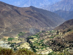
Cosma sits at an altitude of 2650 meters above sea level (masl). It is situated in a key ecological zone known as the quechua (2,300-3,500 masl), a productive agricultural region for growing tubers, cereals, and maize. While the Cosma basin is actually located in an isolated box canyon, surrounded on three sides by the steep ridges of the Cordillera Negra Mountains, it is also located in between two major Preceramic trading routes between the coast and the highland basin known as the Callejón de Huaylas. The sites’ strategic location may account for its importance as a Mito-Kotosh center in the past, and why it exhibits coastal, highland, and vernacular Late Preceramic architectural elements.
Based on survey and archaeological excavations, we now know that the earliest occupation at Cosma dates to the Late Preceramic Period, and habitation appears to have had multiple occupational peaks throughout a 5000-year time span. The complex itself is composed of two early platform mounds, surrounded by Prehistoric terraces and domestic areas that are situated near the modern community, with ancient walls, agricultural terraces, and canals interspersed between the modern farmlands. In addition, the hillsides are home to later domestic structures, an Early Horizon fortress and Inka carved stonework.
_______________________________
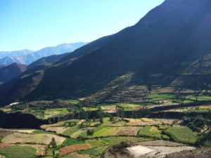
View of the Cosma basin, and Cosma community. Photo taken from the Caja Rumi hilltop, facing towards the northwest. Both mounds can be seen in the photo. Dr. Kimberly Munro
_______________________________
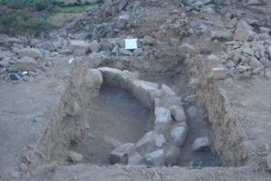
Excavations
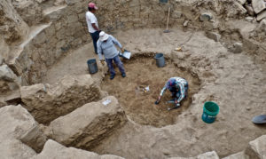
Excavations in Cosma began in 2014 and ran three seasons through September of 2016, focusing on the Late Preceramic mounds at the site. These mounds, known as Acshipucoto and Kareycoto, measure 10m and 18m in height respectively. Surprisingly, relatively shallow into the excavations of the Acshipucoto mound, a large Kotosh-Mito structure was uncovered early in 2014. To date, 6 chamber-like rooms have been documented within the smaller of the two mounds, though only one has been fully excavated. At least 8 radiocarbon dates taken from 3 of these chambers have calibrated date ranges falling between 2819-2462 BCE. The oldest of these rooms, known as “the AC-1 chamber” had not only been ritually sealed similar to other Kotosh-Mito sites, but also included a sunken floor, wall niches, a single entrance way, and a central hearth. While central hearths at other Kotosh centers are typically stone lined with ventilation shafts/flues, the central hearth in AC-1 was a shallow clay fire feature with no real delimiting characteristics. There were no offerings found within the hearth, although a large spondylus shell was recorded just to the west of it. A carbon sample associated with the shell was dated to 2866 – 2572 BCE. This falls in line with the date of the central hearth, 2866- 2500 BCE, suggesting an early tie/connection to a coastal network, given that spondylus come from the warm waters off the coast of Ecuador, and Cosma is located at least 60km inland.
________________________________
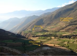
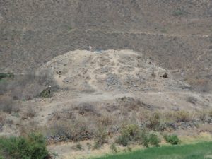
Oblique view of the Cosma basin, with the Acshipucoto mound in the foreground and Kareycoto mound in the background. Photo taken facing towards the north (slightly northeast). Dr. Kimberly Munro
________________________________
View of the Kareycoto and Acshipucoto mounds relative to each other within the research area. Dr. Kimberly Munro.
________________________________
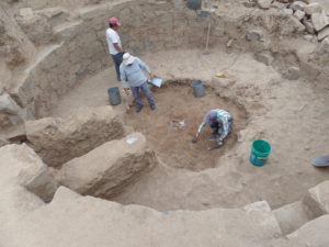
View into the AC-1 chamber during excavation during the 2015 field season. Dr. Kimberly Munro
________________________________
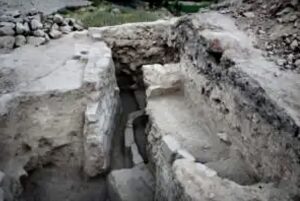
Late Preceramic rooms exposed in the Acshipucoto mound, showcasing rooms rebuilt on top of each other and ritual fill in between. Facing east. Dr. Kimberly Munro
________________________________
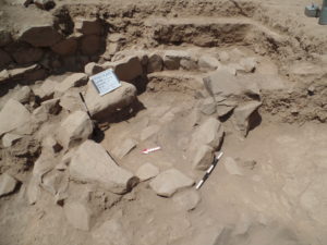
AC-1 chamber in the Achsipucoto mound after excavation. Niches can be seen flanking the entranceway.Photo taken facing the east. Dr. Kimberly Munro
________________________________
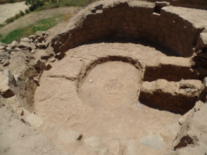
View into the AC-1 chamber after excavation, spondylus shell exposed to the west of the sunken circular hearth. Dr. Kimberly Munro
________________________________
At the larger mound, known as Kareycoto, two hearths were identified in the lower levels of excavation, and at least three separate floor phases and two circular rooms were exposed associated with the Late Preceramic. A Preceramic date taken from one of the hearths in the upper Preceramic floor dates to 2464 – 2207 BCE. Unlike the architecture and purposefully filled chambers in Acshipucoto however, all of the exposed walls had been broken in antiquity. Large rockfill did cover the walls; the consistency of the fill, however, was different from the ritual fill found in Acshipucoto (lacking the deep level of clay capping). This fill also was not clean, or sterile, as the Acshipucoto fill was, and was intermixed with ash and burnt/fragmented animal bones and lithic debitage. Additionally, a black polished stone bead preform and a chipped stone projectile point were collected from an ash lens associated with a broken Preceramic floor. Similar points have been recovered within the Preceramic layers at the type site of Kotosh.
While the hearths documented in the smaller Acshipucoto mound did not include any artifacts, the hearths and ash lenses in the Preceramic layers at Kareycoto included burnt bones, lithics, and at least one large stone blade. A small llama head bead/pendant was also recovered from within an area of ash. This llama bead was carved out of a pale purple soapstone, not local to the area, and is recognizable by its distinct pink/purplish hue. These items were most likely left purposefully in the hearth as an offering, as is the pattern with many Kotosh-Mito hearths in the highlands.
Smaller hearth, fish vertebrates and bones were collected. In addition to the broken walls and lack of clean fill, layers of ash and burnt faunal remains were recovered between the walls of two rooms, as if the burnt remnants from fires were purposefully discarded as part of the fill for the rooms. Some of the ash deposits at Kareycoto were also located “beneath” floors, but critically, the floors were clearly broken above the ash pits. This suggests these informal hearths were created by digging into earlier floors to create a hearth, as opposed to creating new, purposeful hearths, as was the pattern at other Kotosh sites, that often included stone-lining and ventilation shafts. The hearths present in Cosma were simple, relatively shallow, clay-lined features, except for one large stone-lined hearth at Kareycoto.
The remnants of broken or partial walls and presence of at least two preceramic floors have exposed at least four Late Preceramic structures on the Kareycoto mound. From the pattern recognized at other Late Preceramic sites it can be surmised that more rooms are present beneath the layers exposed by our excavations. Considering the rooms/walls exposed are located very shallow into the mound top (2-3 meters into an 18-meter mound), and that most Kotosh-Mito structures are built on top of platforms, and constructed over earlier rooms, we can surmise that the earliest construction of these temples are closer to the lower platform level of Kareycoto (Bonnier 1997; Izumi & Terada, 1972; Onuki 2016).
Located on the eastern edge of the Kareycoto mound, at least two thirds of the way up, an underground gallery was also exposed during excavation. This gallery fits a pattern similar to those found at another large Kotosh-Mito center, La Galgada. The gallery located on the northeast side of the mound slope also illustrates connections to La Galgada (Figure 6.32-6.33). At La Galgada, gallery tombs were constructed after the sealing of old Kotosh-Mito chambers, when the hallways between them were roofed over with large stone slabs and human interments were placed inside (Grieder et al 1988; 60). The gallery at Kareycoto had been previously dug by looters, so no human remains were documented by our team during excavation. Its construction, however, appears to align in function with gallery tombs, rather than the labyrinth style tombs seen under the temples of Chavín de Huántar.
_____________________________
Profile view of the main mound of Kareycoto. Dr. Kimberly Munro.
_____________________________
3D imaging of Kareycoto made from total station points collected during the 2014 season. Dr. Kimberly Munro and the Cosma Archaeological Project.
_____________________________
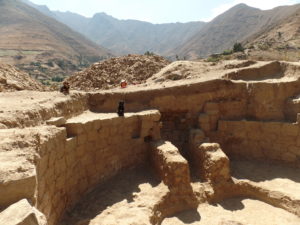
The interior wall/room excavated at Kareycoto. Dr. Kimberly Munro.
_____________________________
Late Preceramic architecture exposed on the top of the Kareycoto mound. Associated with ash lenses and zoological remains. Dr. Kimberly Munro
_____________________________

Stairway leading into gallery within Kareycoto. Dr. Kimberly Munro
_____________________________
While Kareycoto and Acshipucoto were both established during the Late Preceramic, their sequences follow divergent paths after Kotosh-Mito ritual activities ceased within the Cosma basin. The Acshipucoto mound, the smaller of the two, measures 10 m in height and is located a half kilometer across the ravine, due south of Kareycoto. Our excavations revealed at least six separate Kotosh-Mito structures, three of which have radiocarbon dates corresponding to the Late Preceramic. The largest of these structures, AC-1, was a large circular room, 6 m in diameter, located on the SW quadrant of the mound top. Architectural elements included those classified for contemporaneous Kotosh-Mito structures, such as the wall niches, a split level floor, and a central hearth. Moreover, several additional features were present in the room not found at other traditional Kotosh-Mito sites. These included two pony, or half walls, which flanked the entrance; an elevated platform directly across the entrance to the west; and unlike several Mito structures, the entrance into the room was through a platform and 6 steps which sunk down into the structure. Additionally, AC-1 was constructed in a circular shape, a pattern reminiscent of coastal traditions at the time, unlike the majority of Mito temples, which are either square or rectangular with rounded corners. In contrast, the stairway into the room is similar to those stairways seen in the sunken circular plaza styles on the central coast—for example, at the contemporaneous sites of Caral and Sechín Bajo. Finally, the entranceway is flanked by two half, or pony walls, which lead someone entering into the room directly onto the sunken floor. Similar pony walls have been noted for the earliest construction of the circular plaza at Sechín Bajo, which is coeval to the AC-1 room. Only one additional Mito structure has been documented containing “pony walls.” This room, excavated by Daniel Contreras (2010) at Chavín de Huántar, however has been dated well into the Early Horizon.
Interpretation
The past two decades have uncovered a number of additional sites and radiocarbon dates to allow us the opportunity to revisit and rethink the classification for Late Preceramic religious development in the highlands and on the coast.
When we start to include these new datasets, sites like Hualcayan, El Silencio, and Cosma, and their local variations as well as their similar patterns in mound shape and composition, we can add several unexplored, yet documented sites to this list of potential Mito-Kotosh centers.
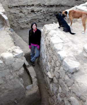
Dr. Kimberly Munro at the end of the 2016 field season, standing “in the Late Preceramic,” with walls/architecture of 4 of Late Preceramic Kotosh-Mito temples exposed. Dr. Munro is leaning against the retaining wall to the AC-1 chamber, which was excavated fully in 2015. Dr. Kimberly Munro
Mounds such as Quellcayrumi in Huanuco, Pueblo Viejo Santa Ana in the Lacramarca valley, Chupacoto in Huaylas, and sites like the Rayan mounds off the Jimbe branch of the upper Nepeña River Valley are all sites that share similarities in mound pattern and composition with either the Acshipucoto mound (low mounds with associated flat “plazas” such as Santa Ana, Rayan), or the Kareycoto mounds (multi-tiered and coma shaped – such as Chupacoto, Quellcayrumi). This list of sites are most likely large Preceramic centers similar in size and scope to the six main preceramic highland centers previously recognized and utilized to create the architectural typology (Kotosh, Piruru, La Galgada, Huaricoto, Hualcayan, and Cosma). By expanding our scope outside of what has been perceived as the traditional geographic region, and including these local variants, the distinction between highland versus coastal traditions may become more blurred, specifically at sites like El Silencio, La Galgada, and Cosma, which include localized variations at individual sites, and can be found along prehistoric trade routes between the coast and highlands.
Cosma’s appearance may add a new classification of sites, bridging a gap in our knowledge of Late Preceramic development and interaction networks in the Andes. As readers will see in the next series installment, the early dates from Cosma may also suggest a reworking of our understanding of state development in the Andes — that it most likely did not originate exclusively in a central locale, either on the coast or the highlands, respectively. Interactions between the two regions were most likely continuous and more fluid than researchers originally may have posited.
*See more about the Cosma Archaeological Project at the Facebook page and website.


