
Editor’s Note: When people generally think of the beginnings of ‘advanced’ civilization—that is, the oldest places in the ancient world featuring spectacular monumental structures, sophisticated artwork, and the other common attributes of such societies—ancient Egypt and Mesopotamia come immediately to mind. Next we think of civilizations such as Mesoamerica, the Harrapa, or Indus Valley, and China. In fact, however, significant monumental centers and pyramids were already arising in South America, most specifically in present-day Peru, during the 3rd and 4th millennium BCE—even before the earliest pyramids of ancient Egypt and the earliest ziggurats of Mesopotamia. Advancing the general public profile of these earliest developments in ancient Peru is substantially overdue…………
Archaeologists have long debated the origin and evolution of state level societies across the world. When does a culture become a state? What are the criteria that mark a state? How did states traditionally develop and expand? Was their development driven by a boom and surplus caused by agricultural developments, warfare, the need to manage communal projects associated with water and irrigation, or was it a more religiously based shift? “Civilization” as we understand it — that is, cultures associated with large scale state-level societies (complex, hierarchical, typically with a ruling class, and elites) — originated independently in 6 geographic areas around the world: Mesopotamia, the Nile River Valley (Egypt), Harappa or the Indus River Region, China, Mesoamerica, and the Andes in South America. Typically, at least for archaeologists, this is marked in the archaeological record by large scale public architecture (or communal buildings), a shared or “state” sponsored religion, a move to intensive agriculture, and a form of writing, or record keeping.
The Rise of Early Andean State Societies: The Coastal Story
This article discusses state development throughout the central Andes by showcasing the earliest monumental complexes and their associated cultures in Peru, the region that would one day give rise to the Inca Empire. For the Andean region specifically, the origins of state development has long been debated. The Andes is a peculiar case study, given that unlike the other 5 “cradles of civilization” mentioned above located throughout the rest of the Prehistoric world, Andean state development did not rely entirely on an agricultural revolution. Large scale public monuments are found along the coast by at least 3700 BCE, and many early centers, especially in the highlands, predate intensive agriculture. We know early humans were in South America at least by 13,000 years ago. These early dates are associated with hunter gatherers who lived in small bands, with one of the earliest of their associated sites, known as Monte Verde, located in the tip of Southern Chile, yielding artifacts associated with a foraging village. By 10,000 years ago, repeated human occupation, including evidence for a variety of crops, faunal and textile remains were found in Guitarrero Cave, in the Peruvian highland valley known as the Callejon de Huaylas.
This time period is referred to as the Preceramic, given the lack of ceramics in the archaeological record. The Pre-ceramic can be divided up into Early (13,000-8,000 BCE), Middle (8,000-3000 BCE), and Late (3000-1800 BCE), based on differing categorical markers and cultural developments.
By 7000 BCE, during the Middle Preceramic, more permanent settlements developed along the northern coast – in the Zana Valley. Small scale mounds point to communal architectural constructions above that of the familial, or household level in this region. Known as the Nanchoc Tradition, these sites are marked by a number of low cemetery mounds, and suggest more permanent claims to the landscape, as well as a level of communal bonding, given the shared construction and burial of the dead within the mounds.
The Nanchoc tradition has been identified based on early cemetery mounds constructed well before the adoption of large-scale agriculture. Dating to 5700 BCE, these mounds are attributed to a group of people who were still considered nomadic, only taking part in incipient horticultural practices on a seasonal basis (Dillehay et al. 1997: 46). The construction and use of the Nanchoc mounds likely came before more permanent settlements in the region. The effort to build and bury the dead within these mounds illustrated that groups had an element of communal and ritual life associated with claiming and returning to the specific landscape in this area, and these structures are some of the earliest permanent indicators of broader communal ties and planning efforts.
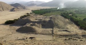
While the Nanchoc Tradition demonstrates some of the earliest examples of communal constructions “above the house-hold level,” and some of the earliest ties/claims by sedentary populations to specific landscapes, the largest and earliest known Late Preceramic monuments of significant size and complexity are found after 2800 BCE, with the construction of the site complexes of Aspero, followed by El Paraiso. For El Paraiso, located only 2 km off the coast in the Chillón River Valley, this center is 60 hectares in size and includes 13 platform mounds, seven of which are organized to make up a central group, which form or outline a U-shaped plaza.
The dates for El Paraiso place its occupation as early as 2300 BCE (Quilter 1985, 1991), but despite its 13 mounds and planned construction, the nearby site of Aspero predate this complex by at least 500 years. It is made up of at least 17 pyramid mounds, six of which were centrally located pyramids organized to form a central plaza, while the individual mounds measured up to 10 m in height (Feldman 1980). The two largest mounds, Huaca de los Sacrificos and Huaca de los Idolos were decorated with clay friezes, had rooms over 10 m square in size, and stone walls over a meter thick. The Aspero complex dates back to 2800 BCE. The organization and monumental pyramids at both these complexes have been used by archaeologist Robert Feldman (1980) to argue for a chiefdom level society at least by this time, due to the size, complexity, and organization of these platform mounds.
_____________________________
Huaca El Paraiso, located in Ventanilla. Marcogg, Creative Commons Attribution-Share Alike 4.0 International, Wikimedia Commons
_____________________________
Norte-Chico
For such early dates, there is one region within central Peru that lays claim to the largest concentration of monumental and complex religious constructions. This region is known as the “Norte-Chico” and has been one of the most informative and influential zones for understanding Preceramic developments on the coast. Consisting of four separate river valleys, (from north to south: Fortaleza, Pativilca, Supe, and Huaura), by the Late Preceramic, at least 30 distinct ceremonial centers were located within this region (Creamer et al. 2007). Sites among these rivers are situated along the coast as well as inland and include some of the earliest evidence for large scale Preceramic monumental constructions, leading some archaeologists to believe that Norte Chico was the epicenter for innovation and more centralized social complexity within the Andes (Haas, Creamer, and Ruiz, 2005).
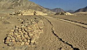
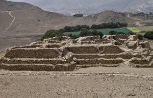
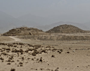
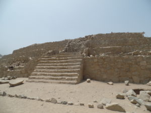
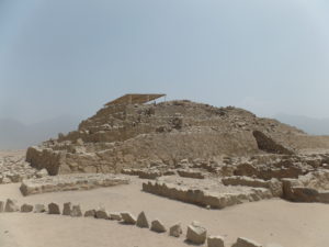
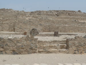
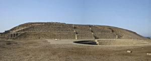
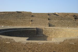
The site of Caral, located 16 km from the coast within the Supe Valley, is considered one of the most important of these early Preceramic centers on the coast, and is also currently classified as the capitol of the Norte-Chico culture. Caral dates back to 2800 BCE, and at the time of its initial carbon dating in 2006 was referred to as “the oldest city in the New World” (Shady 2006). The center includes six different monumental platform mounds measuring between 10 and 18 m high, three sunken circular plazas, a large centralized plaza, a number of smaller mounds, architecture which was arranged symmetrically, as well as an associated domestic area, making up a total complex area of 110 hectares. Eighteen similar sites dating to the same time period can also be found in the Supe Valley, though none are as large as Caral. Because of its size and architecture, Caral is considered by some archaeologists to be the “capital” city of what is now known as the “Caral-Supe Civilization.” This “civilization” includes the other Preceramic sites in the Norte-Chico region, as they exhibit a similar pattern which included large platform mounds and associated sunken circular courts, or plazas.
Caral’s largest mound, now referred to as the “Main Pyramid (Piramide Mayor),” was extremely complex. Measuring 18 meters high, the pyramid had a 10 meter wide stairway that connected a sunken plaza to the top of the mound. There, a large hearth within an atrium was excavated. Another large mound was associated with a sunken plaza, now classified as an “amphitheater” due to the number of associated musical instruments found during excavation (32 pelican and condor bone flutes and 37 trumpet-like instruments made of deer and llama bones.). This sunken plaza was associated with a large rampway leading up to the entrance, and surrounded by semi-circular, short walls, which have been interpreted as possible seating around the plaza. While this mound is smaller than the Main Pyramid, its sunken plaza is much larger. This may indicate that this plaza specifically was utilized for performative, or ritual dancing and music.
Caral’s inland location made it especially productive for farming cotton and other gourds, beans, and chilies. Cotton was extremely important to coastal societies. It was used for their fishing nets, textiles, clothing, containers, and shicra bags. These shicra bags were utilized to carry small bundles of rocks, which were brought in to construct the temples and pyramids at the site, acting almost as sand bags. The productive farming in the region allowed the people of Caral to trade with sites directly on the coast, like Aspero, for salt, mollusks, sardines and anchovies. Caral’s location was also situated for exotic trade with the highlands, making the center productive enough to outgrow Aspero in size and influence. The relationship between Caral and Aspero has led researchers to develop the “Cotton for Fish” model to explain the connections between inland and coastal sites. The theory states that cotton and agricultural crops were grown inland at and around sites like Caral. The cotton at least, was traded to people living on the coastal fisher sites, so these communities could make their nets for fishing traded back to the inland communities to supplement their otherwise plant-based diets (Haas et al. 2005).
_______________________________
Above and below: Views of the pyramidal structures of Caral. Kimberly Munro
_______________________________
_______________________________
_______________________________
_______________________________
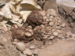
Shicra bags found on location at Caral. Håkan Svensson Xauxa, Creative Commons Attribution-Share Alike 3.0 Unported license, Wikimedia Commons
_______________________________
Earlier Sites
As research continues in the Norte Chico region, new sites with earlier dates have been added to the archaeological dataset. The site of Bandurria is one of these centers. Located along the coast in the Huaura valley and constructed in a similar pattern and style as Caral, the site dates back to 3200 BCE, earlier than Caral (Chu 2008). Bandurria includes two sunken circular plazas, stairways and other terraced/pyramidal mounds. Additionally, the site of Huaricanga in the Fortaleza valley has now been determined to have even earlier dates — around 3500 BCE — making it the earliest in the Norte Chico region. Due to the number of such early dated sites in Norte Chico, several archaeologists have concluded that the beginnings of Andean “civilization” must have started in this region (Haas and Creamer 2006; Piscitelli 2014).
________________________________
Above and below: View of the Late Temple at Bandurria archaeological site. It includes the truncated pyramid and the circular sunken plaza. Guillermo Arévalo Aucahuasi, Creative Commons Attribution-Share Alike 3.0 Unported, Wikimedia Commons
________________________________
________________________________
While the Norte-Chico area was home to the largest concentration of Late Preceramic monumental centers during this time, architectural and complex developments in the Casma Valley, located just a two-hour drive north along the Pan-American highway, cannot be overlooked. The Casma River Valley has been heavily researched and excavated, due to a number of early centers, mostly associated with the following Initial Period (1800-900 BCE), and significant architectural developments following the Preceramic Period. While Casma’s apex appears to have occurred during the Initial Period, several monumental antecedent centers have been noted for the Preceramic Period. One of the earliest sites to date with complex monumental architecture is known as Sechín Bajo. Located 12 km inland from the Pacific coast and composed of three constructed mounds, corporate construction at the center, which dates as early as 3600 BCE, consists of a mix of stone and adobe elements. These early dates were associated with a sunken circular plaza and a two-meter-tall frieze and was excavated by archaeologist Peter Fuchs (2008.)
_________________________________
Sechin Bajo. Rickray1870, Creative Commons Attribution-Share Alike 4.0 International license, Wikimedia Commons
_________________________________
The Late Preceramic for Casma is also known from the centers of Las Haldas, and Huaynuna. Las Haldas, another monumental center, is located 20 km south of the Casma Valley and has been intensely studied. First reported by Engel as a Preceramic site in 1958, research has been conducted by two separate Tokyo Expeditions, Rosa Fung, Terence Grieder, Edward Lanning, and Thomas and Shelia Pozorski. The site itself was initially reported by Engel to include six terraces, constructed in “the shape of a jaguar” (Matsuzawa and Shimada 1978: 653), and the terracing at the center has been referred to as a “temple complex.” Located only 100 m from the Pacific coast, Las Haldas is composed of midden deposits and a large mound surrounded by a series of smaller mounds (Pozorski and Pozorski 1987: 16). Throughout the different excavations, three separate Preceramic midden areas were also exposed.
_____________________________
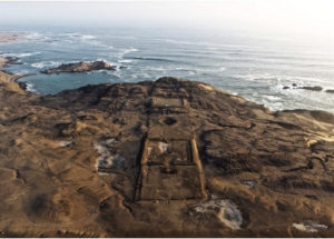
Aerial view of Las Haldas. Proyecto Arqueológico Las Aldas, Creative Commons Attribution-Share Alike 4.0 International license, Wikimedia Commons
_____________________________
Finally, the site of Huaynuna, also located on the Casma coast, includes a large midden, smaller domestic structures, and a “substantially terraced hillside structure” that was interpreted as a small temple complex. Interestingly, the Pozorskis have found evidence for two distinct ritual traditions at this Late Preceramic site. The first included utilizing the temple complex for public/communal rituals, and the second involved a small ventilated hearth structure similar in size and composition to the private ritual constructions associated with the highland Kotosh-Mito (discussed later in this article) tradition (Pozorski and Pozorski 1987, 1990: 17). Huaynuna has been dated to between 2250-1510 BCE (Pozorski and Pozorski 1990: 20). Huaynuna differs from the other Late Preceramic centers mentioned above due to its smaller size and lack of monumental architecture, indicating it was most likely a small but mostly permanent seaside village, as opposed to a monumental ceremonial center.
The Rise of Early Andean State Societies: The Highland Story
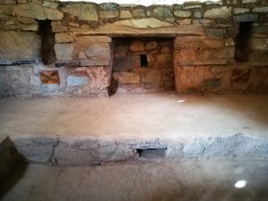
While the coast saw the introduction of large pyramid mound constructions associated with sunken circular plazas (e.g., Norte Chico area, Casma Valley, Salinas de Chao), the highlands were home to a very different architectural tradition. In the central highlands, emphasis was placed on complexes that included clusters of small privatized rooms with single entranceways (Burger 1992: 51). Known architecturally as the Mito or Kostosh tradition (henceforth referred to as Kotosh-Mito), this phenomenon focused on small, closed temple structures, each with a central hearth, low level benches, and niches located along the walls, potentially for the placement of offerings (Bonnier 1987; Burger and Salazar Burger 1980, 1985). Kotosh-Mito structures have been found throughout the Department of Ancash region—mainly in the highlands, at the sites of Kotosh, Shillacoto, Huaricoto, La Galgada, Piruru, el Silencio, Chavín de Huántar and Hualcayan (Bonnier 1997; Bria 2017; Burger and Burger 1985; Contreras 2010; Grieder et al. 1988; Izumi and Sono 1963; Izumi et al. 1972; Montoya 2007; Quilter 1991).
The Kotosh-Mito tradition was originally named after the type site of Kotosh, the first site of its kind to be excavated, located in the Huánuco Valley in the central highlands. Kotosh consists of multiple temple mounds, which were first dug in the 1960s by the Japanese expedition in Peru (Izumi and Sono 1963; Izumi and Terada, 1972).
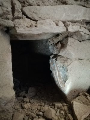
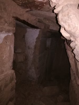
These initial excavations revealed numerous shrine-like rooms, which included interior wall niches and mud relief friezes decorating the temple walls. Additionally, these rooms were built with sunken floors with central hearth features. Each room has been interpreted as an individual temple chamber, differing from the large scale plazas found along the coast at this time. The highland religion, based on architectural evidence, suggests smaller scale ritual activity. Interestingly, before a room was abandoned it was ritually sealed off through a process known as “temple entombment” (Matsuzawa 1972). Temple entombment involved the taking of sterile soil and rocks to seal off the structure, closing it off completely with a clay capping before constructing another temple over the original chamber.
Two of the chambers at Kotosh are unique from other rooms associated with the Kotosh-Mito tradition. One of these is a large temple structure referred to as “The Temple of the Niches,” (Templo de los Nichitos) due to the large number of niches that were constructed in the chamber walls. The Temple of the Niches measured 8.5 x 9.5 m in size and included 23 wall niches, a split-level floor, and burnt offerings found within the central fire feature. Directly below this chamber is the best preserved room at the site, known as “The Temple of the Crossed Hands,” (Templo de la Manos Cruzados). Named as such due to the clay frieze representing two crossed hands, this room is square in shape and measured 9.5×9.3 m in size. The intact walls stood 2 meters tall, and like the other Kotosh-Mito structures, there is a central hearth and split-level floor, as well as over 30 niches. The clay frieze exposed in this room displays two pairs of crossed hands. The hands are symmetrically placed within the room, however there is a difference in size, one larger than the other, suggesting a dual element of masculine/feminine within the Kotosh-Mito ideology.
Excavations at Kotosh further revealed that some rooms were re-utilized, repaired, and altered several times before being ritually closed off. The process of ritual entombment often left a honeycombing of chamber rooms within a site, and the mounds often grew gradually over time, as rooms were sealed off and new platforms constructed.
Dates at Kotosh and the nearby site of Shillacoto place their occupational use well within the Preceramic and Initial Period (2000-1000 BCE.). While the sites of Kotosh and Shillacoto were some of the first of their kind to be excavated, they were not the earliest of these centers to be constructed. To date, one of the earliest known Kotosh-Mito complexes is the site of Huaricoto, located in the Callejon de Huaylas, outside of the town of Carhuaz.
_____________________________
Above and below: The remains of Kotosh. Pitxiquin, Creative Commons Attribution-Share Alike 4.0 International license, Wikimedia Commons
_____________________________
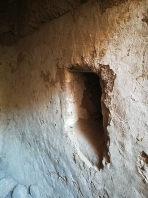
A view inside the Temple of the Crossed Hands. Note the crossed hands frieze at lower left.
_____________________________
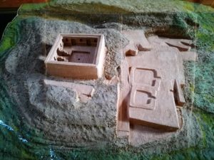
Model of the temple complex at Kotosh, as displayed in the museum.
_____________________________
Huaricoto was occupied well into the Early Horizon (900-200 BCE), however, the earliest date comes from a carbon sample taken from a central hearth in one of the rooms, dated to 2430 cal BCE. Excavations at Huaricoto revealed at least 13 different structures with a similar pattern to those constructions at Kotosh and Shillacoto, including split level floors and central fire features.
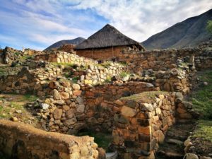
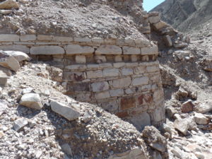
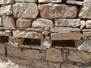
While Huaricoto may have the oldest dates for Late Preceramic highland chambers, for Kotosh-Mito researchers, La Galgada may be one of the most intriguing centers, not only for its early dates and long occupation, but also for the quantity and preservation of the different temple chambers found throughout the site. Located on the Tablachaca branch of the upper Santa River Valley at 1,100 masl in the Department of Ancash, La Galgada is known for its dual mounds, Mito style temples, and a sunken circular plaza (a unique addition not present at the other Kotosh-Mito highland sites). The circular plaza links coastal architectural canons with highland components. Excavated by Terence Grieder, the site’s location along major coastal highland trade-routes may account for its shared styles, as evidenced by a number of exotic trade items recovered from the site (Grieder et al. 1988). La Galgada is to date an exceptional example in its abundance of Mito architecture. The rooms at La Galgada were rectangular with rounded corners and included wall niches, split level floors, central fire features, and single entrances (Grieder el al. 1988). Dates for La Galgada range from 3000 to 1700 BCE, however, the base of the mound and presumably earliest constructions were never reached, indicating there may be earlier structures deep within the complex. The largest mound, known as the north mound, measured 15 m in height at its peak and revealed a unique burial tradition not documented at any other Kotosh-Mito centers. As each temple structure was sealed off, it was re-utilized as a burial space, sometimes housing multiple individuals at a time. Access into many of these rooms were kept open for multiple generations, and a shaft or gallery was constructed after the room was sealed in order to keep access open to the individuals buried within. New burials were continuously added until the room would finally be sealed off, and new chambers were built above these structures.
_______________________________
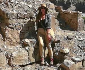
Above and below: Views of La Galgada. In the picture below, if you look closely, you will see the author (in red) perched amidst the remains of the mound. This shows the massive scale of the structure. Kimberly Munro
_______________________________
_______________________________
_______________________________
_______________________________
_______________________________
_______________________________
_______________________________
In total, there are 7 sites in and around the highlands of Ancash and Huanuco that are associated with Kotosh-Mito architecture: Kotosh, La Galgada, Huaricoto, El Silencio, Piruru, Hualcayan, and the Cosma Complex. Dates for these complexes range from the Late Preceramic and into the Initial Period. Comparatively, the quantity and megalithic features of coastal sites far outweighs the sample size recorded to date for the highlands. A number of archaeologists have interpreted this as evidence for civilization originating along the central coast, mostly in the Norte-Chico region (mainly due to the rich marine resources associated with the coastal sites, which could support large populations, cities, and more complex life-ways). The early dates and repeated occupation at Guitarrero Cave, however, paired with new research in the highlands, may indicate that highland developments were equally complex and contemporaneous with the earliest monumental constructions along the coast.
The next article in this series will focus specifically on one such recently documented center — the Cosma Complex. Cosma is unique in its location, situated outside of the traditional Kotosh-Mito cultural zone. Featuring a mixing of highland and coastal elements, Cosma’s appearance may add a new classification of sites, bridging a gap in our knowledge of Late Preceramic development and interaction networks in the Andes. As readers will see in the next series installment, the early dates from Cosma may also suggest a reworking of our understanding of state development in the Andes — that it most likely did not originate exclusively in a central locale, either on the coast or the highlands, respectively. Interactions between the two regions were most likely continuous and more fluid than researchers originally may have posited.
Cover Image, Top Left: View of the site of Caral. JDBENTHIEN, Pixabay
___________________________________
 In the future, article author Dr. Kimberly Munro will be leading groups to see many of the sites discussed in this article, plus many more. If you are interested in participating in this activity, please send an email expressing your interest to populararchaeology@gmail.com. As this project is developed, you will be informed of the details and provided the opportunity to register your place with the group. You can also follow Dr. Munro’s archaeology updates on Instagram @the.field.professor. Pictured here, Dr. Munro is on location at La Galgada.
___________________________________


