
A peer-reviewed paper in the prestigious journal Near Eastern Archaeology reports the first-ever discoveries of ancient Assyrian military camps. Created circa 700 BC during military conquests across the Middle East, they mark the expansion of the Assyrian Empire, which became the prototype for the subsequent Persian, Greek, and Roman empires.
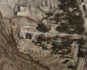
The initial discovery came from a scene carved into the stone walls of the Assyrian King Sennacherib’s palace commemorating his conquest of Lachish, a city to the south of Jerusalem. Matching the landscape in this image to features of the actual landscape (using early aerial photographs of Lachish prior to modern development) created a virtual map to the site of Sennacherib’s camp. This led to ruins similar in size and shape to the camp in Sennacherib’s relief. An archaeological survey of the site found no evidence of human habitation for 2600 years, followed by pottery sherds from the exact time of Sennacherib’s invasion of Lachish, after which it was again abandoned for centuries. Moreover, the ancient Arabic name for the ruins was Khirbet al Mudawwara, “The Ruins of the Camp of the Invading Ruler.”
The Survey of Palestine had investigated a very similar ruin to the north of Jerusalem and found it consistent with a military camp. They hypothesized that it had been built by Titus during the later Roman invasion of Jerusalem. However, Roman military camps were always rectangular, whereas this was oval, the characteristic shape of Assyrian camps. The hill it occupied was known in Arabic as Jebel el Mudawwara, “The Mountain of the Camp of the Invading Ruler.”
This appears to be the site of Sennacherib’s camp from the siege of Jerusalem, which was featured in the three books of the Bible, depicted in great works of art by, for example, Peter Paul Rubens and Gustave Doré, and celebrated in verse by Lord Byron. In the Bible story, the Angel of the Lord passed through the camp in the night slaying the Assyrian soldiers. The Babylonian historian Berosus wrote that a plague devastated the Assyrian army. And the Greek historian Herodotus claimed that mice invaded the Assyrian camp in the night and chewed through their bow strings and shield straps, leaving them defenseless in battle the next morning.
This hill’s earlier history is equally impressive. Isaiah 10:24-32 describes the Assyrian advance toward Jerusalem, culminating with them stopping at Nob and challenging Jerusalem from there. This connects the Assyrian camp at Jerusalem with Nob, the lost priestly city that held the tabernacle, the holiest site in Judaism prior to the construction of the temple. However, according 1 Samuel 21-22, after the priests there aided the hero David, King Saul had every man, woman, child, and animal in Nob killed. Nob was not mentioned again for some 300 years, until the Assyrians occupied it.
In the 1930s, taking advantage of its defensibility, the British built an ammunition storage depot on Jebel el Mudawwara and renamed it Ammunition Hill. In 1948, the Jordanian Arab Legion captured the hill and built a network of defensive trenches. In 1967, in one of the fiercest battles of the Six-Day War, Israeli paratroopers fought through the trenches to take the hill. It is now a memorial and museum of that bloody battle.
Using what has been learned from these first two siege-camp sites, including the distinctive toponym Mudawwara, additional Assyrian military camps have been identified. In some cases, it has also been possible to use the newly discovered camps to locate the sites of ancient cities that were known to have been besieged by the Assyrians but whose locations were unknown or uncertain.
_____________________________
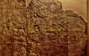
Stone panels commemorating the conquest of Lachish from the walls of the Assyrian Emperor Sennacherib’s palace show his military camp. The twenty-four guard towers in the camp’s perimeter wall, each with three windows visible, indicate a substantial fortification. S. C. Compton
_____________________________
Bottom: The entire scene from Sennacherib’s palace wall as drawn by its excavator, Austen Henry Layard, in 1849. Top: The same landscape as photographed from a plane in 1945, prior to modern alterations to the landscape. Correlating the two indicated a likely location for the ruins of Sennacherib’s camp. Created from two public domain images: Austen Henry Layard’s 1849 excavation drawings of the Lachish relief and a 1945 aerial photograph taken as part of a mapping effort by the British Mandate government of Palestine.
_____________________________
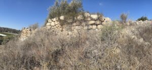
Ruined walls visible today at the site of Sennacherib’s Lachish camp. S.C. Compton
_____________________________
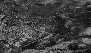
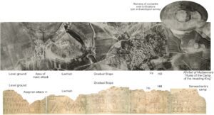
The earliest aerial photograph of Jerusalem (lower left) with an oval fortification visible on a hill in the upper right. Public Domain, from the collection of the Library of Congress.
_____________________________
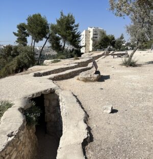
The site of Sennacherib’s Jerusalem camp, now known as Ammunition Hill. S.C. Compton
_____________________________
The peer-reviewed paper, The Trail of Sennacherib’s Siege Camps, by Stephen C. Compton and published in Near Eastern Archaeology, can be accessed through a membership with ASOR.
Cover Image, Top Left: Aerial view of Ammunition Hill, suggested to be the site of Sennacherib’s Jerusalem siege camp anciently. deror_avi, Public Domain, Wikimedia Commons
_____________________________
Advertisement


