
From historic forest fires in Australia to thawing permafrost in Greenland, global warming is wreaking havoc on archaeological sites around the world. The southeastern US is no exception, where heritage sites are being destroyed not only by more frequent and more intense hurricanes, but by flooding and incessant coastal erosion exacerbated by rising sea levels. The 2020 Atlantic hurricane season, for example, made history. It began more than two weeks early, with the formation of Tropical Storm Arthur on May 14, and became the most active hurricane season of the satellite era. That season shattered numerous records, producing the most named storms, the highest number to make landfall in the contiguous United States and the most to strike Louisiana. What does this mean for archaeologists in the Southeastern United States? Hurricanes are just one of many growing threats to the thousands of at-risk heritage sites they are working to document and preserve.
To gain a better understanding of the challenges archaeologists are facing, I interviewed Mark Rees, Director, Louisiana Public Archaeology Lab, University of Louisiana at Lafayette; Sarah Miller, Florida Public Archaeology Network, Chair of the Heritage at Risk committee for the Society of Historical Archaeology; Tad Britt, Chief, Archaeology and Collections, National Center for Preservation Technology and Training, National Park Service; and Meg Gaillard, Heritage Trust Archaeologist with the South Carolina Department of Natural Resources. Here is what they had to say:
_________________________________
Florida • Sarah Miller
Describe the at-risk heritage sites found in Florida.
Miller: The State came up with an informal estimate a few years back of all types of at-risk historic sites: 34,786 sites affected by a two-meter rise and 16,015 sites by a one-meter rise. I tend to focus on the 3,000 archaeological sites to be potentially impacted with a one-meter rise as it’s a smaller number I can start to wrap my head around. These are close to estimates by Anderson et al. that focused more on archaeological sites—3,959 with a one-meter rise and up to 32,301 with greater than five meters in SLR (Sea Level Rise). There are models for SLR that get down to small units like square meters to show it’s not just inching up, but whole pine flats that could flood all at once. Add to that storm surge zones, which change after major storms like Matthew and Irma. Then you have to consider changes to individual sites. Some will erode away, some will become flooded but generally stay in place. Others will be fine, but the access to the sites will flood. Sites that are already submerged are not out of danger either. There is increased temperature and salinity that erode underwater sites as the oceans warm up. There is migration of sea grasses that hold sites in place as they get further under water. In diving, it’s all about more bottom time. As sites get deeper, it will cost more and increased safety stops make dive operations more complicated.
How have past hurricanes and storm events damaged the sites?
Miller: There are sites we know about, that we’ve been able to see and verify their condition. We’ve seen all above-ground features at cemeteries in the Keys wiped out in a single hurricane. We’ve seen the gradual erosion of nine meters of shoreline expose a historic coquina (stone) well that was maybe 20 feet inland and flush to the ground, now fully exposed and the stack of stones detached from the bluffline. We’ve seen flood lines on pre-Columbian mounds from even minor storms. They don’t have to be hurricanes. One of the issues this time of year are the king tides coupled with nor’easters. In St. Augustine, a tornado during Irma came onshore across the lawn of the Castillo de San Marco and wreaked havoc in Huguenot Cemetery. I work for the Florida Public Archaeology Network and I developed the Heritage Monitoring Scout (HMS Florida), which is a participatory site stewardship program to monitor sites to be potentially impacted by climate change. The information I’m sharing here is due in large part to the 1,971 Scout reports we’ve received from 677 volunteers to date.
What impact have storms and hurricanes this year had on these sites?
Miller: This year has had less activity so far, but Sally brought major flooding. After Isaias, we had a Scout report a tree down and artifacts observed on the surface of a mound near Fort Pierce. There is also a pre-Columbian canoe in the same area we’ve had our eye on, which is currently sandbagged to keep it from eroding out of the shore. After Isaias, the sandbags need to be replaced as within a month there was enough wave action to start impacting the site.
Are you noticing an increase in damage to at-risk heritage sites in recent years?
Miller: Oh, yes! We just happened to have our monitoring database up and running right before Matthew hit. At FPAN, we were not tracking it as closely until then. Right away, the database became incredibly useful to track changes over time. The only problem was, in some cases, we didn’t know what the sites looked like before. For example, at one of our flagship sites, we noted after Matthew some impacts, but later saw some of the trees were actually down before that storm. With before and after images, it’s much easier to attribute damage to a storm event with certainty.
How important is it to have archaeologists and citizen scientists in place to monitor heritage sites in real time?
Miller: I’d say absolutely essential. If you look at the Register of Professional Archaeologists, there are 147 archaeologists in the state of Florida. But there are over 180,000 cultural resources listed in the Florida Master Site File. It is really impossible to keep eyes on them all. Many are under state or federal jurisdiction, but many are on private land or in remote areas that are difficult to monitor. It’s also true that after a storm, archaeologists living where the storm hit may have other complicating factors, like their own home has been impacted, or they are deployed to other areas as part of their job. After Matthew, we had a call that there were “shoeboxes” of sherds (pottery pieces) observed near where the shoreline had a new inlet carved out literally overnight. By the time we got to the site, there was a 40-foot pile of sand placed where the sherds had been noted. The Army Corps of Engineers placed the sand as part of a previously approved project and filled in the gap. There was only a short time to observe and record impacts to this area. Another example, at Shell Bluff Landing, we saw a lens (thin layer) of scallops shell not observed before and recorded what we could. The next week another nor’easter came through and the lens was no longer visible.
What threats do future hurricanes and storm events pose to heritage sites in Florida?
Miller: Anything and everything. You never know what will be impacted or where. Sites are disappearing at such a fast rate, and those are the ones we know about. The sites we don’t even know about create another major issue, especially in areas where no comprehensive coastal zone surveys have happened. I read a statistic that Florida has the most number of sites to be potentially impacted, but Louisiana has the most land loss: a football field of land lost every hour to the ocean. In any state, sites that seem safe and upland could be impacted by migration of communities away from the coast in frequent flooding areas.
What is the biggest threat to at-risk heritage sites in Florida?
Miller: Lack of education and coordinated action. It may be easier in other countries where the right to roam and private property do not come in to play as much as they do here in the US. We have lots of jurisdiction issues that are quite complicated and create this patchwork quilt of great disparities between what’s been surveyed, what’s being monitored and managed, and places we have no idea what resources are there nor who is responsible for them. One threat that’s not very sexy, but is a major issue, is our current preservation laws. The main law that protects cultural resources on the federal level, and is replicated on the state level here in Florida, is Section 106 of the National Historic Preservation Act. The process described in that section involves a lengthy consultation, and having permits issued requires a crystal ball to know what will be impacted and where to get coverage for monitoring activities. These sites are disappearing so rapidly, we really need a new system for monitoring that allows for more opportunistic and autonomous monitoring by citizen scientists. Some places have such a participatory site stewardship model in place. We are constantly working with our State Historic Preservation Office, which is very supportive of our efforts. Looking to the future, we hope we can have much greater impact to assist in resilience planning and implementation in the next 30 years, which is critical in the SLR timeline.
Are there actions the archaeology community can take to mitigate these threats to at-risk sites?
Miller: There are great examples internationally and nationally of programs activated to help: SCAPE in Scotland, CHERISH in Ireland and Wales, Midden Minders in Maine, state stewardship programs that are constantly monitoring sites, especially out west. Networking is essential, and borrowing any effective tools from others is important as we are out of time for many to develop programs and resources from scratch. Everyone is doing their part to help reduce carbon emissions and keep the planet and biodiversity healthy. Living shorelines are a great option for sites in places like Florida, so look for opportunities to help with that form of heavy lifting. Stay current in heritage at-risk issues. We have the EnvArch group on Facebook that people can join to share the latest resources and post best practices. If anyone in Florida wants to join HMS Florida, we put out a monthly Scout report with a resource and challenge to keep volunteers active and learning. If you are outside of Florida, the first national site stewardship conference that was scheduled in Las Vegas was recorded and videos will be posted free to all. Let your elected officials know this topic is important to you and that we need to do more to advance regional and local planning efforts. Get in touch with your local State Historic Preservation Office (every state has one) to see if they have a monitoring or stewardship program you can join.
______________________________
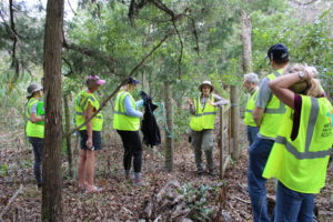
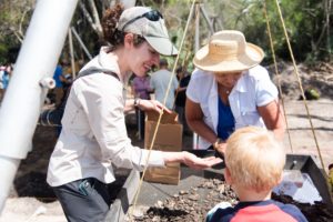
FPAN staff member Emily Jane Murray during a Heritage Monitoring Scout training at Guana Tolomato Matanzas National Esturine Research Reserve (GTM-NERR) outside of Saint Augustine Florida. Courtesy FPAN
______________________________
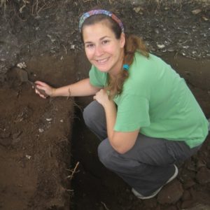
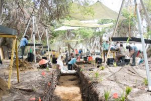
Sarah Miller excavating at the Fountain of Youth Archaeological Park in Saint Augustine Florida. Courtesy Sarah Miller
______________________________
South Carolina • Meg Gaillard
Which heritage sites in South Carolina are most at risk from hurricanes and other severe weather events?
Gaillard: The Heritage Preserve that is most at risk is the Botany Bay Plantation Heritage Preserve, which is where the Pockoy Island Shell Ring Complex is located. As a whole, Edisto Island sees the highest rate of erosion of anywhere in South Carolina. Pockoy Island Shell Ring One is nearly gone. That is currently our top priority — to get in there, excavate and investigate as much as we can before we lose that site. Edisto Island has been watched for a very long time. Its rate of erosion puts it at the top of our list for immediate investigation. Once Pockoy is gone, what is next? Other places like the Tom Yawkey Wildlife Center Heritage Preserve, which is another SCDNR property, also see high rates of erosion. However, I can’t tell you specifically how that compares to other coastal sites and I should be able to do that. That’s the hope of the next step of our investigations — being able to strategically and scientifically analyze the coastline, using applications like the Sea Level Affecting Marshes Model (SLAMM), to see where our efforts need to move quickly so that we don’t lose more sites and lose that data before the next hurricane season.
How important is having a comprehensive strategy for identifying at-risk archaeological sites?
Gaillard: We need to have a way where we can identify a top priority list of sites in every state, so that we can strategically investigate and mitigate sites along the coast. There needs to be a strategic methodology to how we approach the archaeological investigations of these sites. Knowing, for example, that Edisto Island sees the highest rate of erosion, that would propel Edisto Island to the top of the list. Creating the framework and the knowledge base for that information is our next step forward. We really want to collaborate with other states in doing that so that we’re using the same methodology, not just within South Carolina but up and down the coastline.
What type of damage have heritage sites in South Carolina sustained from past storms?
Gaillard: Mostly, the damage is typical land loss. It’s everything between a meter to an entire site. With a high tide or a king tide, we could lose meters of a site overnight. It was approximately 200 feet of beachfront that was lost during Hurricane Irma off of Botany Bay Plantation Heritage Preserve. The small events like a high tide, a king tide, or a massive event like a hurricane can strip away a couple of meters, or they can strip away an entire site overnight. When Hurricane Isaias came through, I was contacting our climate office throughout the weekend, getting updates every eight hours to see where the track of that hurricane was going. It’s not as though I could have jumped in a vehicle with the crew and gone down there and rescued anything, but just knowing what we were losing within those hourly timeframes was in a strange way comforting. We weren’t being completely isolated from the climate data and what was happening. We could strategically plan for when we could get boots back on the ground.
Did Hurricane Isaias damage South Carolina heritage sites this summer?
Gaillard: We don’t know to the meter what we lost, but we do know that we lost some from the Pockoy Island Shell Ring Complex. We received photographs from the property managers at Botany Bay Plantation Heritage Preserve, and we know that we probably lost a good five meters off of that site. Isaias followed the path of Hurricane Dorian pretty tightly, and Dorian did a similar amount of damage to Pockoy. The high tides and strong storm surges, the constant pounding into the earth, that’s where I think a lot of people misconstrue what is destructive and what is not. Some think that if a hurricane doesn’t hit land, there will be no damage or limited damage to an archaeological site. In reality, the tide and rip current, the constant pounding of the surf is actually doing an incredible amount of damage to archaeological sites on the coast, which are literally falling into the ocean day by day. Storms that are miles and miles out into the ocean actually do an incredible amount of damage to sites that are already very fragile.
What can be done to track damage to these heritage sites?
Gaillard: The one big thing that I want to do is implement exactly what Tom Dawson and Joanna Hambly with Scotland’s Coastal Heritage at Risk (SCAPE) have done, as well as what the Florida Public Archaeology Network has been able to accomplish with citizen science programs, where we actually collaborate with people who live along the coast of South Carolina, and ask them to help us document how the coastline looks through photographs and reports. That can help us figure out where our efforts need to focus. Having more boots on the ground in the citizen science realm of things would be exponentially helpful. At the SCDNR, we’ve invited the public out to archaeology projects for over 20 years. With heritage at risk sites like Pockoy, the citizen science aspect—our volunteers—are absolutely essential to getting data out of the ground quickly, efficiently and scientifically. If we didn’t have that citizen science volunteer effort, we would not be able to do the work we do. We’ve counted thousands of hours that they’ve donated to help recover information before it’s lost. If they weren’t helping us, that data, that unwritten record, would be lost to the ocean with the next hurricane season.
Have you been able to document any increase in storm damage to the sites or is the analysis too new to establish a history?
Gaillard: It truly is absolutely new, and that’s why I’m working with people like Tom Dawson and Jo Hambly in Scotland, and Sarah Miller in Florida. Creating this baseline of data on what is most at risk really helps us move forward in our investigations. I think Sarah has the best handle on it above anybody else on the East Coast because of their citizen science efforts with the Florida Heritage Monitoring Scouts program, but even she’ll admit there are huge gaps in the data. We’re trying to figure out how we can fill these gaps and where we need to focus our efforts next. Every hurricane brings a different force inland. We might identify a place like Pockoy as being at risk, but then if Georgetown County gets hit by a Category Four, that totally changes the dynamics of where our efforts need to focus. We’re in the infancy stages of figuring out the long-term impacts to our state, and where our efforts need to focus in the future as storms become more intense and more frequent.
What threats will future hurricanes pose to heritage sites in SC?
Gaillard: My greatest fear is that we will lose sites before we even know they exist. How many archaeological sites are not identified yet that we’re going to lose before we get to them? Pockoy Island wasn’t even identified until 2016, after Hurricane Matthew when the coastline of South Carolina was re-flown, and the two shell rings that make up the Pockoy Island Shell Ring Complex were picked up with LIDAR. People had been walking over them up to that point. That’s a great concern. Then just having the funding and the personnel power to get out there and actually do the work is also of concern to all of us moving forward as we know that these storms are only going to increase in strength, severity and frequency over time.
What is the biggest threat to at-risk heritage sites in South Carolina?
Gaillard: I don’t know if there is one thing. Each site is different, and the threats can change over time. You can split the heritage risks within South Carolina into two major categories. There are the natural impacts, and the human impacts. We had the flood of 2015. We’ve had hurricanes and tornadoes. We’re on an earthquake fault. We’ve had fires. The natural list just goes on and on, but there’s also the human impact of foot traffic over sites, boat wake hitting coastal sites, or people moving into coastal environments, and not doing archaeological investigations before something is constructed.
______________________________
Pockoy Island erosion on both sides. Photo by Jamie Koelker.
______________________________
Part of the archaeology team excavating the May 2018 Pockoy trench. Photo by Taylor Main
______________________________
Meg Gaillard helping volunteers of all ages identify artifacts at a screen. Photo by Taylor Main
______________________________
Gulf Coast and Mississippi River Delta
Mark A. Rees, PhD, RPA
Tad Britt
Describe the at-risk heritage sites found along the Gulf Coast and the Mississippi River Delta.
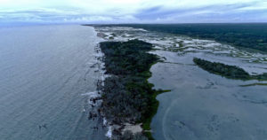
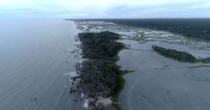
Rees: Louisiana’s at-risk heritage sites include historic standing structures, such as Fort Livingston at Barataria Pass on West Grand Terre Island, and 1,300-year old Native American earthworks, such as Toncrey mounds east of Barataria Bay. There are hundreds of sites with shell midden, some still intact and many others redeposited by wave action, or now underwater, where not that long ago, Native Americans collected shellfish, fished, and hunted. All of the sites on Louisiana’s coast are endangered. An unknown number of sites are unrecorded, submerged, subsided, or destroyed, and previously recorded terrestrial sites are increasingly reported as now lying in open water. The heritage sites being destroyed include cemeteries, with graves marked as well as unmarked, and scattered bones at some sites strewn along the shoreline in each tide. New Orleans has the largest assemblage of endangered heritage, much of it now lying several feet below sea level.
Britt: We are looking at 20 coastal parishes along the coast of Louisiana, focusing more on the mouth of the Mississippi and the Atchafalaya River. There are hundreds of sites out there. They are mainly reachable only by watercraft. You might have a two-hour travel time to get to a site. The marshland is expansive and there are complexes all over it. Basically, every piece of land has had some human impact to it through time.
What are the primary threats to these heritage sites?
Rees: David Anderson and colleagues have recently drawn attention to the adverse effects of sea-level rise on historic properties throughout the eastern seaboard and Gulf Coast. The damage from hurricanes and storm surge is also very serious, but in the Mississippi River Delta (MRD) of south Louisiana, the situation is more complicated and, in many respects, much worse. Heritage sites on Louisiana’s Gulf Coast are critically endangered by a combination of factors: storm surge, relative sea-level rise (RSLR), erosion of coastal landforms, and subsidence. Each of these environmental processes have been around forever, but over the past century-and-a-half the effects have become increasingly anthropogenic—created, intensified, and accelerated by human transformation of the coastal landscape. The oil and gas industry made an indelible mark by dredging canals, laying a vast network of pipelines through the marsh, and obstructing bayous with spoil banks. This has diminished alluvial deposition from seasonal flooding and amplified the effects of subsidence, which is simultaneously increased by the extraction of oil and gas. Much of Louisiana’s coast is near sea level, so this has compounded the effects of RSLR, which we now know is being compounded by eustatic or worldwide sea level rise driven by global warming. Construction of an enormous levee system to protect coastal communities has ironically endangered those communities, as well as heritage sites, by exacerbating the cumulative effects of these anthropogenic processes. Hurricanes and storms can be catastrophic events, bringing intensified wave action and surge inland, accelerating shoreline erosion, and the loss of freshwater marsh, but the aftermath of each disaster must be approached as cumulative and interrelated to other processes in order to begin to understand—and hopefully address—the magnitude and complexity of the crisis.
Britt: There is general subsidence going on in the Delta, so things are sinking. You’ve got storm surges related to hurricanes. A lot of the sites have been impacted by the oil and gas industry. We’ve had canals dug through sites. It’s altered the waterways down there. The Mississippi Gulf River Outlet, which was constructed by the Corp back in the ‘60s, they shut down in the ‘80s because it was having unintended effects.
How have past hurricanes and storm events damaged the sites?
Rees: The most prevalent or visible damage on Louisiana’s Gulf Coast may be the redeposition of cultural materials, in some instances eventually resulting in entirely redeposited sites. Even these sites can provide valuable information on the people who lived there, but once underwater or buried under a meter or more of sediment, the information is less likely to ever be obtained and conserved. Storm surge from a hurricane also causes severe damage by removing trees and killing vegetation with saltwater, accelerating shoreline erosion.
Britt: Threats like wave-action and subsidence can redeposit artifacts, so they jumble up the context of the sites. What’s interesting is that many of the sites were recorded in the 1980s. Since that time, we went out to visit 27 sites and we found 21. The others had been submerged or inundated. We’re rapidly losing sites due to relative sea level rise as well as general subsidence.
How did the storms in 2020, including Hurricanes Laura and Zeta, impact these sites?
Rees: It is probably too early to assess the impacts of the damage, especially since the response is focused on communities and industry, not heritage sites in the broadest sense. Laura made landfall on the Chenier Plain of southwest Louisiana, sparing communities and sites in the low-lying deltaic plain. Historic properties such as standing structures in Cameron Parish were devastated, but the potential impacts on archaeological sites such as the understudied Woodland Period (c. 500 BCE – 1200 CE) shell midden on Johnson Bayou or a nearby, poorly-known cemetery may never be known. Sites such as these are typically revisited as part of cultural resources management (CRM) for regulatory permitting involving a proposed undertaking, not disaster response, especially if the disaster is believed to be “natural.”
Are you noticing an increase in damage to at-risk heritage sites in recent years?
Rees: Site destruction and loss has very clearly accelerated, with archaeologists increasingly not being able to relocate sites first recorded 50 to 70 years ago. This became starkly evident during the response in the aftermath of the Deepwater Horizon oil spill, when nearly half of the previously recorded sites could not be found, or were reported as underwater. These sites are not vanishing. They’re being destroyed by anthropogenic coastal erosion, storm surge, RSLR, and subsidence.
Britt: We’re just now starting the monitoring program. We’re trying to go out and do a basic characterization of the site through drone mapping and real-time kinematic survey on the ground tying in the control points from the drone. We’re getting a very good 3D rendering of the site, and then we can go back and compare those through time. This is a multi-year, multi-institution collaboration. We have a working group and we’ve got Tulane, LSU, ULL, NCPTT, Chitimacha Tribe of Louisiana, US Army Corp of Engineers, and the Coastal Protection Restoration Authority. We’ve got researchers from all of these universities and agencies working on this together. We’re all just getting into this work that we should have been doing years ago.
How important is it to have archaeologists and citizen scientists in place to monitor heritage sites in real time?
Rees: Having boots on the water is critical. A majority of Louisiana’s coastal heritage is accessible only by watercraft, and many sites are so remote that archaeologists may rarely revisit those locations. This dynamic, watery landscape is constantly changing, so rare re-visitations often find much of a site eroded, partially submerged, entirely underwater, or subsided. Unlike Florida, Louisiana does not have a public archaeology network for outreach or the education of citizen scientists for site monitoring. Louisiana’s regional archaeology program was terminated due to a lack of funding, gutting public outreach and education throughout the state. The Mississippi River Delta Archaeological Mitigation (MRDAM) working group has proposed the implementation of a comprehensive program of rapid reconnaissance, site monitoring, and sampling to mitigate the effects of coastal erosion, storm surge, RSLR, and subsidence. The goals are to advance scientific knowledge of long-term historical ecology and human-environmental interactions in the MRD, while also providing CRM planning strategies for alternative mitigation and heritage conservation. Long-term and sustained site monitoring will be essential in producing the necessary baseline data to achieve these goals and objectives, but will be costly and extremely challenging due to the remote locations and rapidly-changing environmental conditions. The MRDAM working group is proposing public education, community outreach, consultations, and additional partnerships in response to the loss of heritage sites on Louisiana’s Gulf Coast.
What threats do future hurricanes and storm events pose to heritage sites along the Gulf Coast and Mississippi River Basin?
Rees: The storm surges from hurricanes are a major threat, especially when intensified by global warming. This is true anywhere in the US, but heritage sites in Louisiana’s Gulf Coast, and especially the Mississippi River Delta, are critically endangered due to the combined effects of hurricane storm surge, coastal erosion, RSLR, and subsidence.
Are there actions the archaeology community can take to mitigate these threats to at-risk sites?
Rees: Absolutely; the MRDAM Working Group is proposing a systematic program of rapid reconnaissance, site monitoring, and alternative mitigation. The scale of the disaster is too large to address by traditional CRM mitigation measures, and regulatory CRM archaeology is frankly not geared to address the magnitude or duration of the unfolding crisis. MRDAM is a multi-institutional, collaborative undertaking that emphasizes public education and the engagement of higher education in this research. With broader recognition of the ongoing loss of heritage on the coast, Louisiana’s residents, politicians, and research universities will hopefully provide greater support for the goals of MRDAM. A multi-institutional research consortium might be most effective, promoting undergraduate and graduate archaeological research, and public outreach along the lines of the State’s former regional archaeology program. Support for the establishment of a Public Archaeology Network would also be beneficial, but would need to be adapted to Louisiana’s deltaic plain and coastal marsh. It needs to be sooner rather than later, however, as these places will not be around forever.
Britt: This is an analogue for what’s going on in deltas around the world. We are using this as a case study to compare and contrast with other deltas around the world.
____________________________________
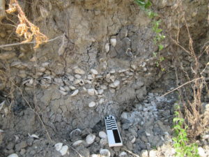
Detail of a rangia midden exposure. Photo by Tad Britt, NCPTT
____________________________________
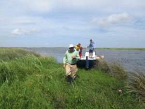
Tad Britt, NCPTT, Dr. Kory Konsoer and Students conducting site recon at 16LF292. Photo by Sam Huey, PAL
____________________________________
Advertisement


