
How do people want to experience the past? It’s a question that challenges history museums. For some, “the past” is code for a simpler, more relaxed place, green and never-changing. Others expect to learn something or to see the world from a different perspective. Some want to be entertained. Most anticipate some experience of beauty. Given such diverse expectations, it is no wonder that history museums are offering an ever broadening array of programs and opportunities.
Early in the spring of 2013, experts at the Colonial Williamsburg historical site in Williamsburg, Virginia introduced a new way of looking at the past. Virtual Williamsburg (http://research.history.org/vw1776/ ) is an interactive 3D computer model that invites visitors to explore Virginia’s eighteenth-century capital on the eve of the American Revolution. At this stage in its development, the model encompasses the Capitol neighborhood at the east end of town, presenting both the interiors and exteriors of five key sites (the Capitol, the Secretary’s Office, the Dickson Store, the Raleigh Tavern, and the Old Playhouse), and the exteriors and historical landscapes of an additional 28 structures. Modeling of the adjacent Armoury neighborhood is already underway and there is more to come. Following a one-year pilot project in 2005-06, the initiative to create an entire model of the town began in 2008. This project has been a collaborative effort pairing architectural historians, archaeologists, and curators with modelers from the Digital History Center and The Institute for Advanced Technology in the Humanities (IATH). Generous funding has been received from the Institute of Museum and Library Services, the National Endowment for the Humanities, and the Andrew W. Mellon Foundation.
Computer modeling might sound like an unlikely undertaking for a museum so heavily invested in physical reconstruction. More than 80 years of research and craftsmanship at Colonial Williamsburg have resulted in the restoration of a town: more than 450 structures, along with streets, greens and gardens. This seems to beg the question: Isn’t a virtual world a bit redundant? In fact, Virtual Williamsburg is not meant to recreate what visitors can already see. Instead, its construction marks a new way of looking at and understanding Williamsburg as a functioning community. Through the virtual model, visitors will eventually be able to access reports, images, manuscripts, and records, enabling a remarkable level of interactivity.
In both its capabilities and its appearance, this virtual version is not the Williamsburg where your parents honeymooned. In fact, even the most seasoned Williamsburg visitor may find the model a vaguely unfamiliar place. Gone, for example, is the Capitol building that has been toured by generations of school children… but for good reason. Instead of presenting a generalized past, Virtual Williamsburg presents a very precise one. Visitors are dropped into the town on May 15th, 1776, and find themselves in a landscape populated only by buildings, businesses and tenants whose presence could be accounted for on that day. Not only does this present a more unified and historically accurate picture, but it captures a more vibrant town. Some buildings are under construction while others exhibit peeling paint. And of course some of the most familiar facades are no longer part of the scene. By May 1776, Williamsburg’s first Capitol building, on which the present reconstruction was based, was a distant memory, having burned in 1747. In its place stood a new Capitol, completed in 1753, with a portico that faced the main street. Once thought too elusive to rebuild, the details of the second Capitol’s appearance have been ferreted out by recent researchers, and are on display (both inside and out) in the virtual model.
________________________________________________________________________________________
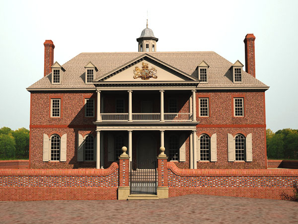 The Second Capital (completed 1753). Courtesy Digital History Center, Colonial Williamsburg Foundation.
_______________________________________________________________________________________________________________________
While some familiar landmarks may be missing, Virtual Williamsburg introduces new buildings to the eighteenth-century landscape. Just behind the Capitol, visitors encounter The Old Playhouse, an imposing (and somewhat disheveled) barn of a building. Between 1999 and 2001, archaeologists exposed the remains of this theater which staged some of Williamsburg’s most celebrated diversions between its rapid construction in 1760 and its abandonment in 1772. By May 1776 it had already been shuttered for 4 years. Colonial Williamsburg has not yet rebuilt the theater in the Historic Area. As a physical reconstruction, its eighteenth-century design (lacking aisles and illuminated by candles) strains the flexibility of modern fire- and building codes. The model, however, serves as a visual repository for what researchers currently know, and a testing ground for the theater’s future design. More importantly, it provides general admission and a backstage pass for those curious about the world once experienced by Williamsburg’s theater goers, which included Thomas Jefferson and George Washington.
_________________________________________________________________________________________
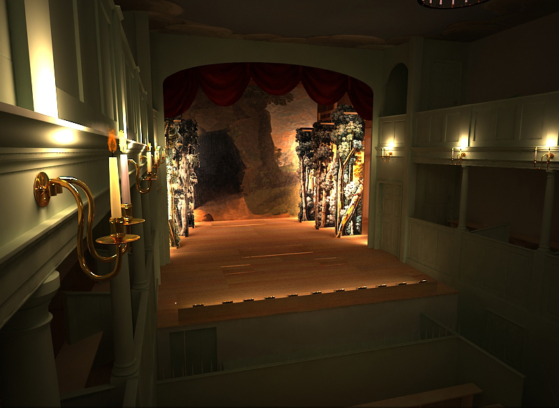 Modeled interior of the Playhouse. Courtesy Digital History Center, Colonial Williamsburg Foundation.
_______________________________________________________________________________________________________________________
Backstage at the theater is not the only inaccessible space to which Virtual Williamsburg provides access. Freed from concerns for physical safety, the model permits virtual visitors to mount rickety ladders and descend narrow stairs to encounter some of Williamsburg’s more interesting and evocative spaces. Those inaccessible above- and below-stairs spaces were most familiar to Williamsburg’s “other half” ..…more than 1,000 enslaved workers who inhabited Williamsburg at the time of the Revolution. Making these spaces more visible, if only virtually, broadens a visitor’s perspective on how people lived in the eighteenth century.
_________________________________________________________________________________________
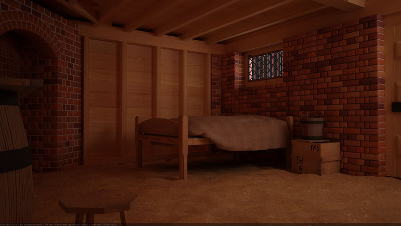
Slave quarters below stairs at the Dickson Store. Courtesy Digital History Center, Colonial Williamsburg Foundation.
______________________________________________________________________________________________________________________
But what does any of this have to do with archaeology?
At first blush, Virtual Williamsburg seems to be an architectural endeavor, and indeed, Colonial Williamsburg’s architectural historians have been heavily invested in the model’s development. But look closely and you will see archaeological fingerprints as well. Some are in predictable places. Physical reconstruction has always drawn on excavated evidence for footings, foundations, and fence lines. The model, too, has made use of this information. More interesting, however, is the rendering of archaeological information that has never seen the light of day….elements of the landscape that might be repellent, or illegal, or even ecologically impossible to recreate. Computer modeling has allowed archaeologists to present a more accurate and interesting view of the past while dodging the attendant hazards.
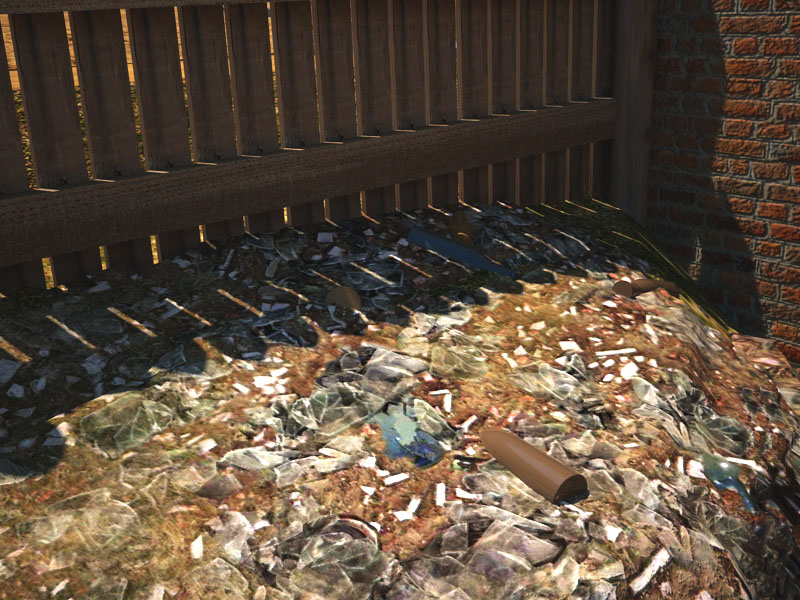
Take, for example, the interpretation of eighteenth century “yardscapes.” Today’s visitor experiences Colonial Williamsburg as a very tidy place. The grass is mowed, the walks are level and well maintained and the yards are lush and lovely. Such was not the reality for Williamsburg’s eighteenth century residents. Brick rubble or marl might—or might not– purchase shaky footing on wet paths. Chamber pots were emptied into yards or open ravines, laundry water pooled in outdoor work areas and kitchen refuse littered the yard. How do we know this? Ask an archaeologist.
Poor drainage and an ever-present supply of trash defined living conditions for nearly all residents of eighteenth-century Williamsburg. The story repeats itself on virtually every excavated site, but rarely with such flourish as at the Coffeehouse near the end of Duke of Gloucester Street. There, use of the property as a public house and then as the Dickson Store resulted in the accumulation of large and successive trash deposits—one midden yielding 70,000 artifacts— on three sides of the building. While Charlotte Dickson and her son, Beverley, made an archaeologically verifiable attempt to spruce up the lot after acquiring it in 1772, a midden on the west side, and a bottle dump on the east remained poorly concealed. It seemed somehow disingenuous to unfurl rolls of sod across this landscape prior to the Coffeehouse opening in 2009. And yet, what else could be done? Authenticity has its limits.
A 3D model allows museums to convey such difficult things. The messy and the smelly, the dangerous and infectious can be informed by archaeological evidence, and rendered visible but innocuous by computer modelers. Of course, that process is significantly more complicated than it sounds. Dr. Peter Inker, of Colonial Williamsburg’s Digital History Center, recently described the process of modeling the Coffeehouse trash midden. Modelers began, he explained “[with an] archaeological photograph of the freshly uncovered surface of the midden. This was then taken into imaging software to create a larger square image that could be tiled onto any surface. As the original midden would quickly have been covered by dirt and erosion deposits, a layer was added in the imaging software over the ‘clean’ midden deposit to make it look slightly buried. Finally a layer of weeds was added to begin to get the effect of a midden that had been left undisturbed for a while. The resulting image was then applied on the topography in the area we know the midden was deposited.” One wonders what the eighteenth-century contributors to the Coffeehouse midden might make of such an extraordinary effort.
__________________________________________________________________________________________
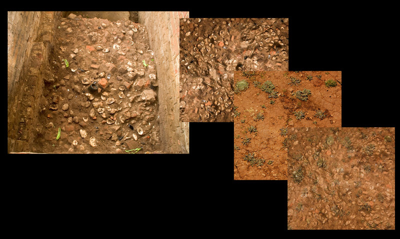 Steps taken to create a modeled midden. Courtesy Digital Imaging Center, Colonial Williamsburg Foundation
_______________________________________________________________________________________________________________________
The Coffeehouse site is one of the first to have its “yardscape” recorded in Virtual Williamsburg. As archaeologists uncover new details about historic land use, that information can be easily integrated into the model, making it a dynamic reflection of ongoing research.
 The bottle dump at the Coffee House. Courtesy Digital Imaging Center, Colonial Williamsburg Foundation.
_______________________________________________________________________________________________________________________
Although excavated landscape features have contributed interest and accuracy to specific sites in Virtual Williamsburg, overall topography has had an even greater effect on the model. In the early stages of modeling everything is rendered on a flat plane, which highlights the importance of the terrain for making Virtual Williamsburg convincing as a “real place.” Modelers began their quest for a more nuanced eighteenth-century landscape with the 1929 topographic maps of the town, recorded just before Colonial Williamsburg began affecting major changes to the Historic Area. Then, eighty years-worth of archaeological maps helped with the fine tuning, with recorded elevations from late eighteenth-century layers adding detail. What one noticed– after a considerable effort –was that where the land was flat, contours have changed little over the last 200 years. But very little of Williamsburg started out flat.
Williamsburg’s earliest permanent settlers claimed a landscape that was deeply etched by creeks and ravines. Four-hundred years later, that same landscape is a jogger’s dream with a gentle and level terrain, devoid of any coronary dangers. What happened? Archaeological exploration confirms that between the 17th and 21st centuries, Williamsburg experienced a gradual “flattening” as residents did battle with a ravine- riddled landscape. Some of their efforts to tame the topography were swift and deliberate. In his 1724 publication The Present State of Virginia, the Reverend Hugh Jones wrote that “…to make the main Street exactly level, the Assembly lately gave a considerable Sum, which was expended in removing Earth in some Places, and building a Bridge over a low Channel, so that it is now a pleasant, long, dry walk broad and almost level from the College to the Capitol.”
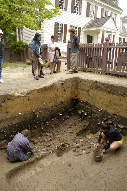
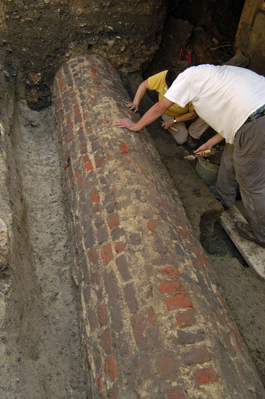 Leveling the streets is no easy task, particularly in the centuries before earth-moving equipment. Recent excavation at the east end of town has highlighted the effort expended in accomplishing the task. Vaulted brick drains were constructed to redirect storm water under the now filled streets. Those early drains became the backbone of elaborate brick drainage systems by which later property owners endeavored to make soggy lots dry, and those that were sloped, level and inhabitable. In 2011, archaeologists exposed a 4 meter length of arched brick drain (pictured left) at the Revolutionary War period Public Armoury site…a tie-in to one of the storm drains described above. Its identification as a 1770s improvement to the lot suggests that even half-a-century after initial efforts to tame Williamsburg’s landscape, the struggle continued.
In fact, the struggle appears to have intensified as Williamsburg’s available real estate began to dwindle. Lots that were marginal and unclaimed early in the eighteenth-century suddenly appeared more promising toward mid-century. Nathaniel Walthoe, a businessman, and Clerk of the Council, purchased a precipitously pitched lot near the Capitol in 1750. There he constructed a 35’ x 35’ “storehouse”, a building that would later become the Coffeehouse and, eventually, Dickson’s Store. Excavation reveals just how disruptive Walthoe’s construction was to the stable ravine on which it bordered. Water coursed around its foundation, carving erosion channels that trapped garbage from the adjacent street. A retaining wall constructed to stem that flow of water trapped five feet of sediment against the building’s southwest corner, gradually leveling terrain along the front. Left unchecked on the northeast side, however, coursing storm water etched deeply into the destabilized ravine. Excavation in 2010 revealed evidence of the dramatic changes in topography wrought by construction of a single building.
Of course not all of the changes to Williamsburg’s topography were accompanied by such drama. The ravines that characterize this Tidewater region were natural and convenient repositories for household trash, and were filled gradually over the centuries. In 2011, archaeologists excavating west of the Public Armoury (a 1778 military repair facility currently undergoing reconstruction) found themselves six feet below grade in a ravine whose filling began prior to (1630s) colonial settlement. Encapsulated within the ravine was an artifactual history of the land’s occupation beginning with Native Americans, followed by refuse from an early eighteenth-century tavern, the Revolutionary War-period Armoury, and an extended family of freed slaves in the 19th century. Colonial Williamsburg’s efforts in the 1920s to seal and level that landscape were written in 2’ of yellow clay that eradicated all visual evidence of this former ravine. While the artifacts recovered from the feature told an important story, so too did the changing terrain.
__________________________________________________________________________________________
Excavation reveals 18th century scouring behind the Coffeehouse. Both actions resulted from construction in an unstable location.
_______________________________________________________________________________________________________________________
 Archaeologists excavate a refuse-filled ravine west of the Armoury.
______________________________________________________________________________________________________________________
Physically reconstructing eighteenth-century topography is not a practical solution, and yet without its restoration, key parts of the story are lost. The relatively easy fix enabled by computer modeling allows viewers to visualize an earlier landscape, and to appreciate, for example, how an open ravine might have contributed to the Armoury’s security, or how tenuous a foothold early construction held in the competitive market near the Capitol.
_________________________________________________________________________________________
 The Armoury ravine (foreground) contributed to security measures. Courtesy Digital History Center, Colonial Williamsburg Foundation.
_______________________________________________________________________________________________________________________
If archaeological evidence has been credited with dirtying and roughening the virtual landscape, its softening effects deserve equal billing. Colonial Williamsburg’s archaeologists have collected considerable information about the eighteenth-century environment over recent decades, providing hard evidence for Williamsburg’s “curb appeal.” The model provides a suitable canvas on which to publicly paint that picture.
Just as a 1929 topographic map served as the base point for modeler’s rendering of Williamsburg’s eighteenth-century terrain, so travelers’ diaries provide a place to start with the environment. The picture isn’t always pretty. John F.D. Smyth, visiting Williamsburg in 1770, describes the city this way: “the street [is] deep with sand, (not being paved) …. and is very disagreeable to walk in, especially in summer, when the rays of the sun are intensely hot, and not a little increased by the reflection of the white sand, wherein every step is almost above the shoe, and where there is no shade or shelter to walk under, unless you carry an umbrella. . .”. [A Tour in the United States of America. 1784] The Williamsburg that Smyth encountered in 1770 left a deep impression as a bright, hot, and tree-less place. But how accurate is that characterization, and how do we know?
The capture of information about the eighteenth-century environment has evolved slowly, aided by new technology and ever more perceptive questions. Between 1930 and 1960, excavation techniques were not focused on the recovery of environmental information, leaving landscape architects to fill “question marks” in the landscape with Colonial Revival gardens considered appropriate to the period.
Some of the earliest environmental evidence collected by Colonial Williamsburg’s archaeologists came from wells excavated in the 1960s. A well on the property of John Custis, wealthy landowner and avid gardener, produced branches of American holly and Dutch box, still green after two centuries of submersion. In 1965, archaeologists made a similar discovery inside the well at Henry Wetherburn’s Tavern. There, leaves and clippings from Virginia pine, sugar maple, black walnut, cotton wood, mountain laurel, red cedar, mulberry, and red oak, helped to fuel Colonial Williamsburg’s first attempted environmental reconstruction of a yard.
Since 1980, the development of the field of archaeobotany has reduced archaeological dependence on such random and site specific finds. Seeds (macro-botanical remains), and their micro-botanical counterparts, pollen and phytoliths (silica casts of plant cells) are now included in the arsenal of evidence employed to reconstruct (at least on paper) past landscapes. Each of these categories has strengths and weaknesses. Seeds are the largest and easiest to recover and count, but rarely survive in the soil unless excessively damp or charred (the latter, a more frequent occurrence than one might expect, given open hearth cooking). Pollen is abundant and indicative of the variety of tree cover and vegetation, but it rarely stays put. In the ground, pollen is prone to percolation through the soil. Perhaps more troublesome, in its historic context it is known to blow long distances on the wind, making it a reliable indicator of regional, but not immediate, vegetation. Phytoliths, the most recent addition to the archaeobotanical lineup, are relatively heavy, meaning that they don’t stray far from their place of original deposit. But not all plants produce phytoliths, and our collection of comparative samples for eighteenth-century plants is still quite small.
In short, archaeologists recognize that no form of botanical evidence can indicate what type of tree or plant or grass grew in a specific location. Taken as assemblages, however, seeds, pollen and phytoliths have the potential to answer a variety of more general questions about environment and land use. Arboreal pollen provides a glimpse of forest composition. The growing requirements of represented plant species may indicate whether a location was shaded or open, well- maintained or left to seed. The presence of weedy materials suggests untended spaces or soil disturbances.
Given the potential value of this information, collecting soil samples has become as rigorous as the collection of artifacts. Where conditions are favorable, large bags of soil are retained for flotation, a process that isolates surviving seeds. Small bags of soil are routinely taken from each layer and archaeological feature to capture pollen and phytoliths. Where archaeologists encounter deeply stratified deposits, such as the ravines described above, collection of a continuous “column sample” through the succession of fills, or a “core sample” through underlying deposits, permits a look at environmental change over time.
________________________________________________________________________________________
 Collecting a column sample from the Armoury ravine.
_______________________________________________________________________________________________________________________
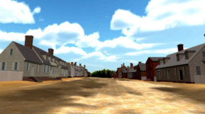
What all of this sampling has revealed is a change in Williamsburg’s vegetation during the course of the eighteenth century. The first half of the century saw a relative abundance of trees (hardwoods and evergreens), accompanied by a variety of shrubs. By the second half of the century, however, the arboreal pollen begins to dwindle and there is an uptick in the presence of opportunistic weeds and grasses. This suggests a decline in local forests, and a corresponding rise in grasses that populated the now-open area. Opportunistic weeds suggest instability: untended yards, open ditches, and trash deposits. While there is wide internal variation with this pattern, it seems that our traveler, John F.D. Smyth was telling the truth: by 1770 Williamsburg was an open, dry and perhaps oppressive place……and so it has been modeled.
Archaeobotanical evidence provides a fair amount of specificity about the surrounding environment during the second half of the eighteenth century. Pine, oak, maple, hornbeam, birch, chestnut, hackberry, ash, walnut, persimmon, sycamore, and sweet gum were among the trees present in the mix. Virtual Williamsburg has integrated this information only very generally into the model in the creation of a leafy frame at the edges of the town (placement suggested by Revolutionary War cartographers). As both the project and the accompanying landscape software develop, the model will continue to be infused with greater detail.
Lisa Fischer, Director of Colonial Williamsburg’s Digital History Center, emphasizes that the recent launch of Virtual Williamsburg is a starting line, rather than a finish. The model provides a framework in which a variety of information can be collected, stored, and rendered, to produce a perspective quite different from ours today. This is a continuous process, and viewers can expect the scene to evolve as new data and discoveries are incorporated into the view shed. As an interpretive tool, computer modeling has wide-ranging benefits, especially for archaeologists, whose findings can be difficult or inconvenient to recreate in a physical setting. Virtual Williamsburg provides an opportunity for archaeological data to escape the covers of site reports and to be appreciated on a level–or at least a more accurately rendered– playing field.
_________________________________________________________________________________________
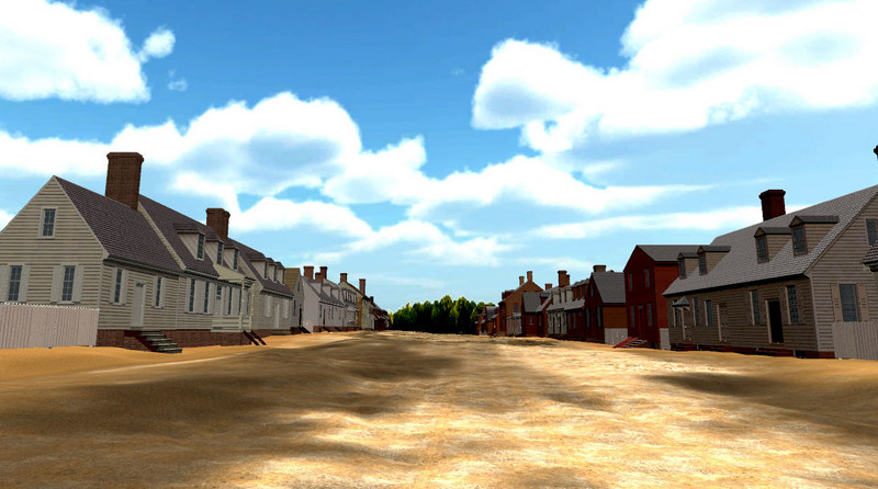 A tree-less Duke of Gloucester Street as we believe it appeared in May 1776.
_____________________________
Unless otherwise noted, all images courtesy Colonial Williamsburg Foundation.


