
Smartly timed to coincide with the Smithsonian Folklife Festival on the Mall in Washington, D.C., the Smithsonian’s National Museum of the American Indian has presented “The Great Inka Road: Engineering an Empire,” the first major bilingual exhibition on one of the greatest civilizations in South America. The exhibit opened June 26 and will run through June 1, 2018. It explores why and to what end the Inka Road was built more than 500 years ago, and how its construction, without the use of metal or iron, the wheel or stock animals to pull heavy loads, stands as one of the greatest engineering feats of all time.
The paved road is more than 24,000 miles in length, runs north to south crossing through Argentina, Bolivia, Chile, Colombia, Ecuador and Peru. The Inka Road engaged impressive engineering strategies in response to the challenges presented by the rugged Andes mountains. This landscape ranges from coastal desert to high plateau and uneven cordillera (a system of mountain ranges) separated by valleys characterized by biodiversity and many unique ecosystems.
The items on display are intended to illustrate important concepts in Andean cosmology, the principles of duality, reciprocity and integration, and offer examples of the road’s infrastructure and spirituality. Features include images, maps, models and 140 objects, including a ceramic Chavín stirrup spout bottle (the oldest item in the exhibition, ca. 800–100 B.C.), impressive gold ornaments, necklaces made from shells from the Lambayeque region, stone carvings, silver and gold figurines, and various textiles made from camelid hair and cotton.
The Inka Empire, the final period of autonomy and pure indigenous tradition in South American history, began in the 14th century and flourished until the Spanish invasion in 1532. Throughout its 100 years of use, the extensive road served as a complex network and major axis for communication, transportation, expansion, administration and political control of vast and varied territories throughout the Inka Empire. After the Spanish invasion, the road lost its original symbolism and its political meaning, but it never lost its significance as a symbol and sacred space to indigenous people in the region. Contemporary descendants of the Inka continue using the road system and millions of people still speak the native languages of Quechua and Aymara. The Inka Empire ultimately transformed the world through the dissemination of important crops, minerals and medicines.
_____________________________________
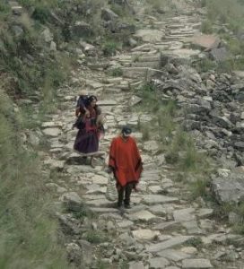
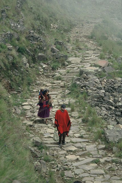 Walking the Qhapaq Ñan, part of the Inka Road, in Jujuy, Argentina. Photo by Axel E. Nielsen, 2005
________________________________________________
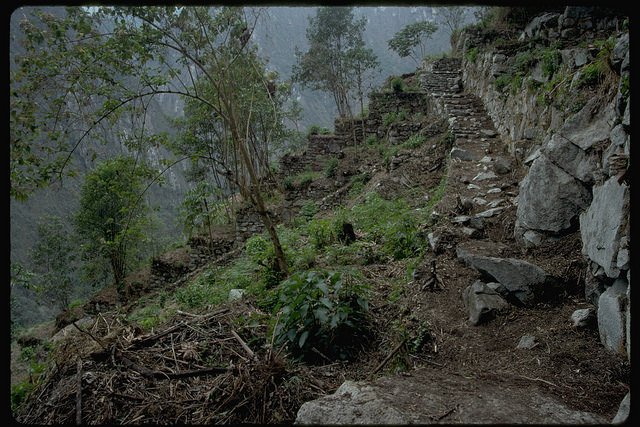 Portion of the east flank trail at Machu Picchu, Peru (Wright Water Engineers, Inc., 1998)
__________________________________________________
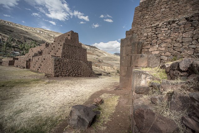 The Rumi Colca gateway, Cusco, Peru. Photo by Doug McMains, 2014.
_____________________________________________________
The exhibition unfolds the history of the Inka Empire in 11 sections:
- The introduction includes a “flyover” of a segment of the road system so visitors can see its magnitude, complexity and enormous scale.
- The story of the beginning of the road explains how the Inka rose to power and constructed the road swiftly, building upon the contribution of earlier civilizations.
- Visitors learn about the ancestors of the Inka and how the foundations of the empire reside in their early creation stories and a spiritual understanding of the universe.
- A section about the city of Cusco takes visitors to the heart of the Inka universe and reveals how it was the capital of the Inka Empire and embodied the physical, political and spiritual center of the Inka Road, as all roads led to and from Cusco. Three-dimensional renderings of the city and existing architecture at the time of the Inka are a central part of the visitor experience along with video elements and images presenting the city today.
- An immersive experience includes walking through four suyus, or four distinct regions, that make up the Inka Empire, also called Tawantinsuyu, which means “four regions together,” and shows how the Inka integrated a vast number of villages, ethnic groups and diverse ecosystems. One of the interactive games has visitors managing the Chaski runners. These individuals were relay messengers who carried information throughout the empire via the Inka Road. Another innovation included the khipu, or numerical knot system, which was a complex and sophisticated system of record keeping. Visitors are challenged to decipher the strands and check answers on a sliding panel.
- Chinchaysuyu is the largest suyu and the empire’s most important agricultural region. Innovative engineering solutions to the complicated terrain are highlighted by the rope suspension bridges. A group of communities along with a bridge master who live north of Cusco have been continuously making a suspension bridge for more than 500 years from local grasses in their homeland. They constructed a similar bridge spanning more than 60 feet on the National Mall as participants at the 2015 Smithsonian Folklife Festival. A portion of that bridge will reside in the exhibition.
- Antisuyu covers the exotic and difficult terrain of the Amazon rainforest, prized for its medicinal plants and bird feathers. Innovative engineering is demonstrated by the water management at Machu Picchu.
- Collasuyu is the second-largest suyu, a pastoral area for llamas and alpacas and rich in gold, silver and copper. The Inka built a system of tampus (way stations) to accommodate travelers on the road.
- Contisuyu is the road to the sea, providing key resources of fish and guano. The Inka built a system of colcas (warehouses) along the road to store goods and developed terrace farming to increase agricultural land and to take advantage of microclimates.
- The section on the Spanish invasion shows how the road gave their armies easy access to the empire and how the introduction of new animals, plants, beliefs, laws and diseases transformed the lives of Andean people, ultimately bringing devastation to the land and the road.
- Finally, a video shows the continuity of Inka culture and traditions today, how the road still binds more than 500 communities and honors the Andean peoples for their unique contributions to human achievement.
__________________________________________
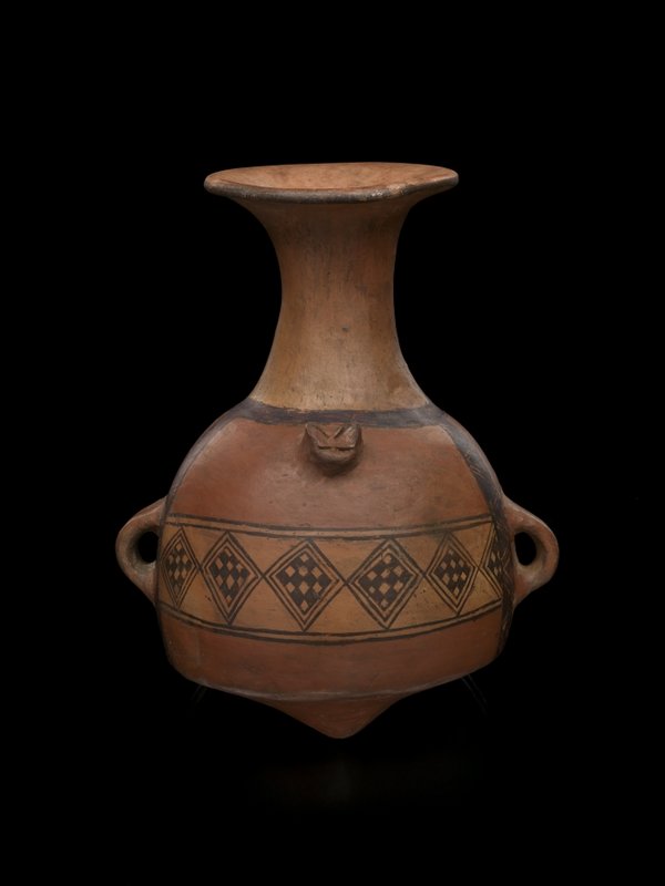 Exhibited: Inka arybalo, ca. AD 1450–1532. Juan Benigno Vela (Pataló), Ecuador. Ceramic, 17 x 23 cm.
The arybalo is a ceramic form unique to the Inka period. This form was standardized and produced throughout Tawantinsuyu (the Inka Empire), and was found in all sizes. While the form of the arybalo was consistent, the designs on each vessel were often particular to the region where it was made. These vessels were used in many ways, from personal “water bottles” for travelers or workers to making and storing chicha (fermented maize beer). Photo by Ernest Amoroso/National Museum of the American Indian
________________________________________________________
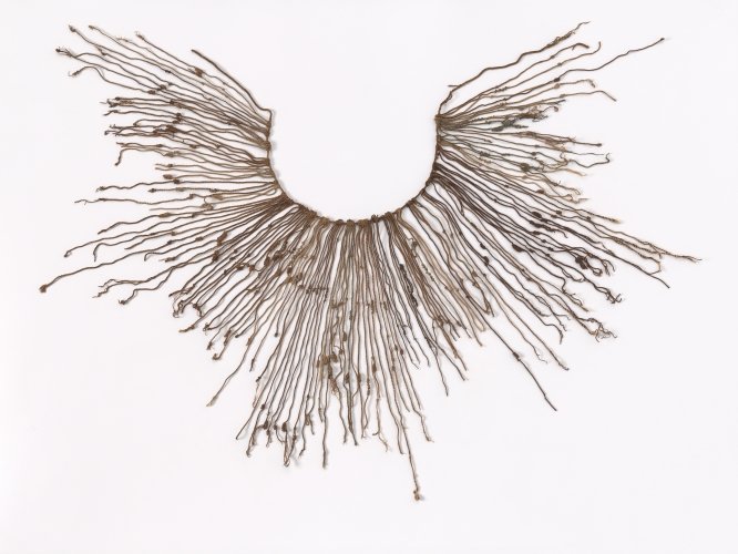 Exhibited: Inka khipu, AD 1400–1600. Nasca region, Peru. Cotton, 103 x 48 cm.
Khipu were Inka recording devices made of wool or cotton strings knotted in various ways and sometimes dyed different colors. They were composed of a primary cord from which hang secondary cords that carry the information. Khipu were used to record census reports, the movement of goods and people, historical events, and religious and military information. Ernest Amoroso / National Museum of the American Indian
________________________________________________________
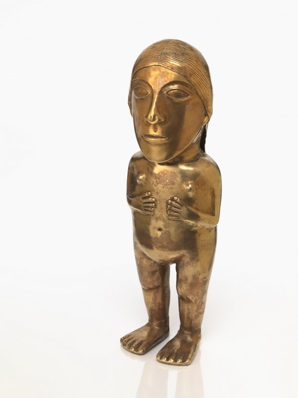 Exhibited: Gold Inka figurine, AD 1470–1532. Coastal Peru. Gold, 9 x 7 x 24 cm.
The gold figure represents an important Inka woman. Gold was a sacred material to the Inka, so its use and display was highly restricted. Figurines like these were left as offerings at religious spaces or worn as ornaments
by members of the Inka elite. This figure may have been dressed in miniature textiles when it was used as anoffering during the Inka period. Photo by Ernest Amoroso / National Museum of the American Indian
______________________________________________________
Exhibition curators Ramiro Matos (Quechua) and José Barreiro (Taíno) have spent the past six years researching, traveling and documenting the Inka Road in preparation for this exhibition.
“The Inka are one of the primary examples of the achievements of the indigenous people in the Western Hemisphere,” said Kevin Gover (Pawnee), director of the museum. “Their knowledge, their understanding of their environment, their agriculture and, of course, their engineering all remain infinitely interesting and instructive particularly in a world that is grappling with some quite near existential challenges of sustainability. There is knowledge to be gained from the examination of these indigenous cultures not simply for the sake of gathering knowledge, but for its application in our contemporary lives.”
The exhibit will be presented to the general public until June 1, 2018. Admission to the National Museum of the American Indian is free. For more information, visit www.AmericanIndian.si.edu.
________________________________________________
Every year, local communities on either side of the Apurimac River Canyon use traditional Inka engineering techniques to rebuild the Q’eswachaka Bridge, set on the Inka road. The entire bridge is built in only three days. The bridge has been rebuilt in this same location continually since the time of the Inka.
________________________________________________
Edited and adapted from a Smithsonian press release: Inka Road Remains a Monumental Achievement in Engineering After 500 Years of Continuous Use, May 14, 2015
________________________________________________
In addition, the latest Popular Archaeology ebook is now available.
______________________________________________
Travel and learn with Far Horizons.

____________________________________________

 Popular Archaeology’s annual Discovery Edition eBook is a selection of the best stories published in Popular Archaeology Magazine in past issues, with an emphasis on some of the most significant, groundbreaking, or fascinating discoveries in the fields of archaeology and paleoanthropology and related fields. At least some of the articles have been updated or revised specifically for the Discovery edition. We can confidently say that there is no other single issue of an archaeology-related magazine, paper print or online, that contains as much major feature article content as this one. The latest issue, volume 2, has just been released. Go to the Discovery edition page for more information.
____________________________________________


