A single-engine Cessna soars over the tropical Mesoamerican forest, revealing the splendors of an ancient city in stunning, three-dimensional detail. Such stories, and the breathtaking images that accompany them, have captured the popular imagination over the past decade, as Maya archaeologists have incorporated Light Detection and Ranging (LiDAR) technology into their toolkit. Sophisticated imaging techniques used to visualize these high-resolution remote sensing data have revolutionized settlement pattern studies in the region, allowing archaeologists to study ancient Maya cities and their surroundings at a level of detail previously unimaginable. Our work at El Pilar has been at the leading edge of this tectonic shift in Maya studies, and we continue to push the boundaries of what LiDAR can help us learn about life in the Maya Forest.
_____________________________
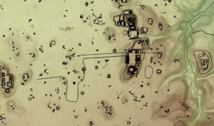
Fig 1: Animation of aerial LiDAR survey.
_____________________________
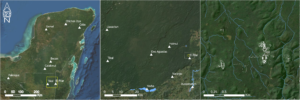
Fig 2: Map of the El Pilar site and its local and regional context. Thomas Crimmel
_____________________________
El Pilar and LiDAR
El Pilar is a large Maya center, located on the edge of an elevated limestone escarpment that extends north and west into Petén, Guatemala, the heartland of Maya civilization in the southern lowlands. The modern Belize/Guatemala frontier splits the site epicenter—the “downtown” core containing the largest temples, palaces, and administrative buildings—roughly in half, with monumental structures spread over two kilometers in both countries. Anciently, this location was politically strategic, placing El Pilar within 50 km of the massive capital Tikal to the west, between 10 – 20 km from the major centers Naranjo, Holmul, and Xunantunich, and within the same distance to numerous medium-sized sites in the upper Belize Valley to the south. Several distinctive landforms—upland ridges, foothills, lowland plains, and the Belize River valley—also converge at an ecotone near this area, which provided a range of plant, animal, and geological resources to the ancient inhabitants. Twenty-square-kilometers of protected reserve land now surround El Pilar in Belize and Guatemala, but the influence of the city in ancient times would have spread over a much larger area.
_______________________________
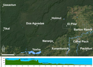
Fig 3: Central Maya lowlands and elevation cross-section (El Pilar within its local context and the elevation profile). Thomas Crimmel
_______________________________
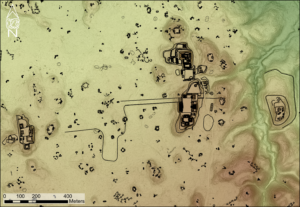
Fig 4: Map of El Pilar core area showing structures in their context (“downtown”). Thomas Crimmel
_______________________________
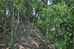
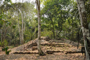
Above and below: Most of the El Pilar structures remain enshrouded in foliage, a natural strategy for conserving its remains. Courtesy BRASS/El Pilar Program
_______________________________
Archaeological projects across the Maya region now employ LiDAR, and most share the primary goal of settlement prospection: the identification of ancient occupation over vast expanses of dense tropical forest. Areas that would take years or decades to systematically survey on foot can be imaged in hours or days, allowing researchers to locate new settlement areas, understand the extent of cities, and generate population estimates. Our settlement survey program at El Pilar shares these goals, although we view settlement prospection somewhat differently. Knowing where people lived, and estimating how many people lived somewhere, are important aspects of understanding life in the past, but settlement and population size are only the starting points for understanding how the Maya lived within, and shaped, their environment.
_______________________________
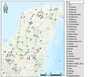
Fig 5: LiDAR surveys in the Maya lowlands (after Canuto).
_______________________________
Above: Settlement features validated after LiDAR at El Pilar, from 1986 to 2020. Thomas Crimmel. Slideshow by canva.com
_______________________________
More Than Monuments
We have integrated LiDAR imagery into settlement surveys for seven years to examine the landscape beyond “downtown” El Pilar. Images produced by processing LiDAR data provide a starting point for ground-truthing settlement remains. We have documented over 1,862 structures over the 14 square kilometers surveyed to date, with more to be added by future work. LiDAR provides the most accurate renderings of topography that, when analyzed in Geographic Information Systems (GIS) software, can produce detailed datasets to measure the slope of the ground surface, the flow of water, and other facets important to understanding how the Maya used their landscape.
______________________________
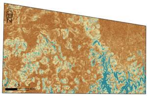
Fig 7: LiDAR slope classification at El Pilar. Slopes range from 0 degrees (dark brown) to 90 degrees (dark blue). Thomas Crimmel
______________________________
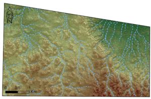
Fig 8: LiDAR-derived water flow model at El Pilar. Elevation ranges from the high (red) to low (green) with contour lines (brown) indicating 10 meters of difference. Thomas Crimmel
______________________________
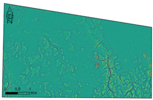
Fig 9: LiDAR-derived hilltop and basin locations at El Pilar. Concavity ranges from convex (yellow) to concave (dark blue). Thomas Crimmel
______________________________
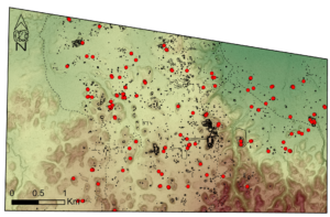
Fig 10: Validated Looter’s Trenches (red points) at El Pilar. Roads (dotted lines) and architecture (black lines) are also shown. Thomas Crimmel
______________________________
The landscape of ancient Maya cities included more than houses and monumental precincts. A quick examination of any Maya settlement map will show large open spaces between residences, and the topographic detail revealed in LiDAR images allows archaeologists to model how the Maya may have used those seemingly “empty” spaces (see Figure 4). For example, calculations of the slope of the ground surface, derived from LiDAR measurements, reveal what areas within El Pilar were suitable for farming. Working from the premise that slope gradients above 14-degrees would be too steep to effectively grow crops, we can exclude these areas of the landscape from analyses of food production capacity, and we can apportion the remaining areas into individual farmers’ fields using our GIS. This gives us a starting point for modeling which areas within the city were intensively managed for resource production and which were left as managed forests. Sophisticated hydrological models, also partially based on slope measurements, provide methods to explore how water flowed, pooled, and was perhaps diverted and stored. El Pilar is separated from the Belize River by 10 km of rugged terrain, so managing water supplies—especially during the months-long dry season when no rain falls—would have been imperative to its inhabitants. Analyzing these aspects of the landscape brings us much closer to understanding the experiences of thousands who lived in similar centers across the Maya Lowlands.
Maya cities also contain a variety of features related to landscape management that are neither residences nor public structures. Our survey efforts have mapped a range of landscape modification features—aguadas (small reservoirs), berms, chultuns (storage pits), depressions, quarries, and terraces—that may, or may not, display strong LiDAR signatures. Long, linear features, such as terraces stretching more than 100 meters, show up clearly in LiDAR images, while smaller, irregularly shaped berms often do not. Large and deep aguadas may also be easily identified, but smaller aguadas, as well as depressions possibly serving similar water-storage functions, typically await discovery in the field. Quarries and chultuns have proven to be the most elusive features in LiDAR images, although the subterranean nature and small size of chultuns makes their low visibility predictable. Understanding the distribution of these features indicates how the Maya used different areas of their cities, and how intense their activities may have been.
_______________________________
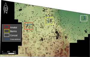
Fig 11: Example areas at El Pilar showing locations and cross-sections of Amatal, Berms, and Corozal. Thomas Crimmel
_______________________________
Fig 12: LiDAR image of Amatal, points of interest, and survey results. By Justin Tran. Slideshow by canva.com
_______________________________
Fig 13: LiDAR image of Berms, points of interest, and survey results. By Justin Tran. Slideshow by canva.com
_______________________________
Fig 14: LiDAR image of Corozal, points of interest, and survey results. By Justin Tran. Slideshow by canva.com
_______________________________
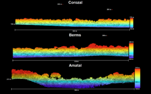
Fig 15: LiDAR cross-sections of Amatal, Berms, and Corozal (Note: High points are unidentified flying objects!)
_______________________________
Making Sense With Traditional Knowledge
Interpreting how archaeological features, and the “empty” spaces around them, combined to form the structure of an ancient Maya city is not a simple process, and it cannot be accomplished without an appropriate frame of reference. To understand how the Maya domesticated the landscape in and around their cities, and to begin unraveling the meaning encoded in settlement and topographic data, we have partnered with Indigenous citizen scientists since the beginning of our research program. The contemporary Forest Gardeners of the Maya Lowlands are living encyclopedias of traditional ecological knowledge, skills, and practice. Their insights about land use and agriculture provide bridging arguments to make sense of ancient occupations.
Traditional knowledge of agricultural methods is particularly important to developing models of landscape use and management in ancient Maya cities and the contemporary Maya Forest. The Indigenous foundation of food production in the Maya Forest is the milpa cycle, which is frequently derided as “slash-and-burn” agriculture and cited as a factor in environmental degradation. Our citizen scientist partners, however, reveal the complexity of the milpa cycle: using hand tools, fire, and skills accumulated over generations of living in the forest, Forest Gardeners carefully tend their plots to provide food, construction materials, utensils, medicines, and many other necessities of daily life. They manage the succession of forest plants and trees in these fields, over an average of twenty years, to ensure the ability to produce goods that transcend their “daily bread.” In addition to their direct productive utility, milpa land management practices endow ecological benefits including animal habitat and water conservation, soil fertility maintenance, and erosion reduction on the Maya Forest landscape. We have learned about the wealth of resources this managed forest environment can provide through close collaboration with our citizen scientist partners—who help us identify and map the distribution of economically useful plants in the forest today—and we have incorporated this knowledge into hypotheses for understanding the lives of their ancestors.
_______________________________
Fig 16: Example tree species identified by citizen scientists at validated mapping points. By Justin Tran. Slideshow by canva.com
_______________________________
Understanding Life in the Forest
The synthesis of archaeological data, LiDAR imaging, and traditional ecological knowledge at El Pilar pushes our research into new realms of understanding. Our settlement survey, for example, has identified numerous mounds that are the remains of ancient structures, sometimes arranged together in groups and sometimes in isolation. Archaeologists regularly view these mounds as household remains and use counts of mounds as the basis of population estimates. Forest Gardeners across the Maya Lowlands, however, traditionally build small structures in fields located away from their homes. This information allows us to distinguish primary residences—the main home of a household, consisting of more than one mound—from secondary residences or field-houses, which would enter the archaeological record as small, isolated mounds and impact population estimates.
Knowledge of the traditional size of milpa plots, which typically average about one hectare, informs our efforts to understand how space was used at El Pilar. We are building land-use models that combine this information with LiDAR slope data to examine how land may have been allocated within the milpa agricultural cycle, which will reveal the dynamic and complex landscape this cycle could create. Modeling the milpa cycle allows us to explore the productive potential of the city and the forest in which it was built, and to test prevailing explanations that the Maya deforested their environment.
Work at El Pilar endeavors to understand life in the Maya Forest, both past and present, by bringing together different threads of knowledge to expand the limits of archaeological research. While the acquisition of LiDAR data continues to have a profound effect on our archaeological survey, it is the inclusive nature of our project that propels our research forward. Incorporating LiDAR has greatly benefited our settlement survey and enhanced our ability to topographically model the landscape. Our citizen scientist partners enrich our understanding of this landscape and work with us to build land-use models that reflect traditional practices. The combination of these different ways of knowing has a synergistic effect, which deepens mutual understanding across cultures and creates a more holistic framework for conducting research, and we are excited about the direction we are headed.
_______________________________
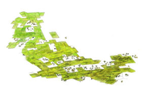
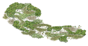
Fig 17: Above and below: Is it “Field or Forest” or “Field and Forest”? It is not a trade, it is a cycle.
_______________________________
_______________________________
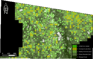
Fig 18: Milpa cycle land-use model incorporating LiDAR-derived slope measurements and validated sites.
_______________________________
If you liked this story, you may also like The Milpa Way, and Mysterious Maya ‘citadel’ begins to reveal its secrets, published previously at Popular Archaeology.
_______________________________
Advertisement
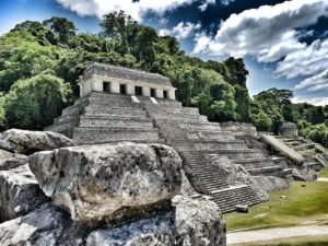
Courtesy ktzito, Pixabay
_______________________________
Join us for an unforgettable mega-trip with Dr. Anabel Ford to see ancient Maya cities: Rainforest Kingdoms: Maya Archaeology under the Canopy
Advertisement


