

Little is yet known about the disparate groups that moved into the fertile coastal areas of Dhofar province in southern Oman around the end of the first millennium, or ca. AD 1000. Each was undoubtedly attracted by its opportunities and resources, but their settlement histories, and particularly their origins, remain opaque — none more so than the mysterious Minjui or Minju people who rose to prominence during the last millennium.
This article notes the various origin theories but does not add to them or attempt a resolution. Rather, it presents two surviving structures in Dhofar as being of possible Minjui construction and examines what they may tell us about the activities of the group.
There are some little-known historical references to a group of people known as the “Minjui,” who were supposedly the last dynasty to rule over ancient Merbat [Mirbat] at the eastern end of the Salalah bay in Oman. They then abandoned it, moving west along the coast to the site of modern al-Baleed that, confusingly, they also named Merbat. This information comes to us in the invaluable history from a wide network of Arab historical accounts kept by Colonel Samuel Barrett Miles (1838-1914) of the Indian Army and Political Service, while serving in the region – chiefly eastern Arabia – over many years. (1)
Although even in his day the true origins of the Minjui were obscure, Miles reports indications that they were possibly of Persian origin. Another source he reports claimed that the Minjui originated in the ancient region of Balkh, astride the silk road in northern Afghanistan. (2)
The uncertainty of their origins persists to the present. In a more recent (2019) discussion of sites in Dhofar from “Late Antiquity” [ie. 350-700 AD], Lynne Newton and Juris Zarins note what they term the “mystery and intrigue” surrounding the peoples known as the “Himyari,” and “Minju.”(3)
They further propose: “One theory of their origins could be that they represent groups who originally visited Khor Rori seasonally and who stayed behind and lived in the area after the collapse of Shabwah, post 400 AD (such as the Manji Indian merchants…).”(4) Their book suggests that the history of the ancient town of Zafar, that developed into the capital, Al Baleed, after the collapse of Khor Rori, may hold the key. Here, by around 1000 AD, the Mandju/Mandjawiyyun rose in dominance, variously nominated by historians in that era as Persian, or merchants who travelled to the Tihama and Zabid in Yemen; still others describe them as the Bulukh from southwest Yemen, the local Shahra hill tribes, or a merchant class from SW India. (5)
A useful partial historical chronology of al Baleed/Zafar in which the Minjui feature frequently between AD 970 – 1254 is also given. (6)
The lack of agreement among the scholars of that era about the origins of the Minjui strengthens the likelihood that the collective name covered a variety of peoples, not merely those of a single origin.
Tangible remains of the Minjui
Tombs
In his accounts, Colonel Miles describes locating several Minjui tombs near Robat that dated, according to the headstones, to AD 1020 (AH 411) but without providing further details. (7)
Buildings of uncertain function
Multiple ruins in the area have also been attributed to the Minju, Miles commenting that “…it is to the Minjui that the numerous heaps of ruins scattered over the plain and indicating the ruins of former towns are usually ascribed, and it is curious that so little mention has been made of this family…” (8)
__________________________
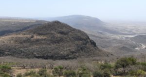
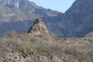
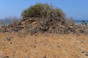
Inland from Khor Sowli, this promontory on Jebel Nashib contains one of several “forts” along the northern edge of the Salalah plain that may have been built by the Minjui to oversee and protect trade routes from the coast.
__________________________
In an official government atlas published in 2013, authors Zarins and Newton have also noted some other buildings on the Qara coast that may have been erected by the Minjui. In particular, they note a large stone building atop the prominent promontory of Jebel Nashib (Jebel Kasbar), overlooking a route from Khor Sowli to the interior. They note that its layout, complete with large plastered water tanks, is similar to another hilltop fort at Ain Humran.
Further, they report that local informants claimed that the Jebel Nashib structure, and another complex at Wadi Shaboon, closer to Mirbat, were built by “the mysterious” Minjui. With the Jebel Nashib building at least, both the base and outer casing is formed from large finely cut blocks of limestone. (9)
Given our current level of understanding about the era as a whole and Minjui capabilities in particular, obviously little can be ruled out; what can be stated is that these larger buildings bear very little resemblance to the two structures located further west on the Qamar coast that will be discussed next. Only the building technique and the materials used appear similar, but that is likely a function of the environment they share. Regardless of who built them, the Qamar coast buildings seem to be inland forts guarding important routes from coastal ports.
_______________________
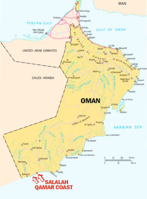
MAP of Oman showing the location of Salalah and the general area of the Qamar coast.
_______________________
The tower structure at al Hauta
[Lat. 16°46′ 6″ N (16.76833333333333° Decimal), Long. 53°29′ 21″ E (53.48916666666667°).]
A useful but preliminary study of shrines in Dhofar, published in 2010, notes a shrine located in a village on a short stretch of the Qamar coast east of Rakhyut. The shrine is named bin Othman, after the man who arrived in Dhofar from Aden in the 11th century, whereas the village and the coast more generally are termed al Hauta. This section of the coast is intersected by two major wadis and one minor wadi.
The village, the shrine and its associated mosque are located at the mouth of Wadi Ahjawt, the westernmost and largest of the three wadis. The end-note of the study (note v) concludes with a passing reference that is relevant here:
… there is a stone tower (kūt) on a rise closer to the foothills of the steep jebel here. A local story is that the “Minjuwi” had a cable attached to it from above and it is how they got supplies from on top of the jebel to the small village below (an archaeological assessment of this site is in preparation by the author). (10)
_________________________

A view of the tower in Wadi Ahjawt facing northwards, showing the steep gully on the eastern side directly below the structure.
_________________________
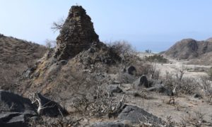
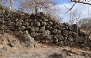
A view of the structure taken on the small plateau on the north side, at the level of its base, facing southwards toward the ocean and the tiny modern community.
_________________________
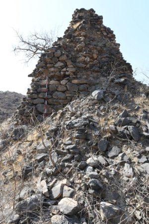
The al Hauta structure with a large pile of rubble adjoining.
_________________________
In December 2021 and March 2022, this author undertook an assessment of the structure and the entirety of the al Hauta coast and its wadis, reported here for the first time. No proper examination of the plateau above the wadi for traces of the presumed higher end of the pulley system has yet been made.
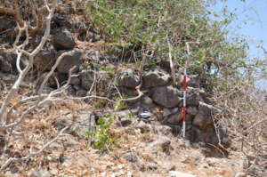
The structure can best be described as a squared tower, tapering to a small summit that shows signs of collapse. It may, of course, have been a little taller in antiquity, but presently stands a little over 6 meters (about 20 feet) tall. As shown in image 6B, on each of its 4 sides raised rectangular panels are prominent, reaching vertically toward the summit from the top of the base, which comprises the lower third of the entire tower. This base level is constructed from larger rocks than the upper two-thirds.
At this stage it remains unclear whether the panels have a structural function or are merely decorative. The entire structure, including the panels, is constructed of uncut stone without mortar being used.
_______________________
A view revealing details of the tower, taken facing in a north-easterly direction.
_______________________
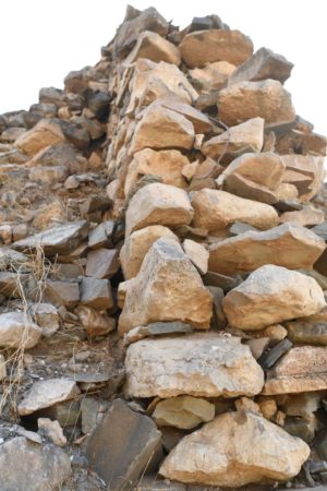
Image 6B: Closeup view showing the construction style of one of the stone panels on the side of the structure.
_______________________
The fact that this small coastal strip was isolated from the plateau above and from communities along the coast in both directions, being only accessible by sea until very recently, strengthens the reasonableness of an innovative solution such as a pulley system being constructed to send supplies to the community below.
_______________________
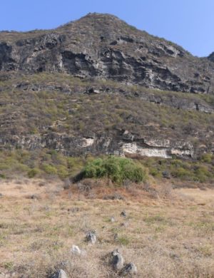
Foreshortened by a moderate telephoto lens, this view shows the higher terrain behind the al Hauta structure.
_______________________
That this same situation is true of the second location, Khor Kharfot, seems unlikely to be coincidence.
The tower structure at Khor Kharfot
[Lat.16°43′ 53″ N (16.731388888888887° Decimal), Long. 53°20′ 18″ E (53.33833333333334°).]
_______________________
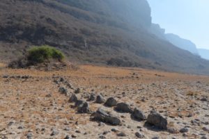
A view facing northwards of the collapsed structure at Khor Kharfot with the higher terrain directly above. Part of the double alignment of stones running down from the main structure is visible in the foreground.
_______________________
Khor Kharfot is the mouth of Wadi Sayq, the major drainage of the Qamar mountains, which reaches the Indian Ocean roughly halfway between Rakhyut and Dhalqut. Other than entering through the wadi from the interior plateau, the difficulty in reaching the coastal strip overland is undoubtedly a major factor that has isolated the location despite it having several freshwater springs and abundant vegetation, including trees. It is still accessed mainly by sea.
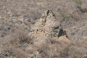
Nevertheless, although currently uninhabited, Khor Kharfot has a significant number of sites evidencing periodic occupation in the past. The first archaeological evaluation of the place was made by Paolo Costa with the author in 1993. His general assessment expressed the belief that the human traces there represented occupation from at least the Iron Age down to the Islamic period. Of the collapsed structure that he termed “the most conspicuous remains of the entire area,” he conjectured that the “tall mound of walls and debris [is] possibly the ruin of a solid tower several meters high.”(11)
In 2014, a fuller examination of the collapsed structure was made by Carl Phillips and Michele Degli Esposti as part of a team effort led by the author. Of this structure, dominating the east side of the bay, Phillips and Degli-Esposti concluded that it “…in all likelihood represents the collapsed remains of a squared tower built in large unhewn stones.”
__________________________
The collapsed structure at Khor Kharfot is seen here in this view facing southward over the bay.
__________________________
Construction details of the collapsed tower structure at Khor Kharfot.
Image courtesy of Michele Degli Esposti, 2014. In Khor Kharfut (Dhofar). A reassessment of the archaeological remains (in press, Journal of Oman Studies, fig. 9b).
__________________________
After noting that it is connected to three other features of unclear purpose – a roughly rectangular stone enclosure adjoining the ocean side, an almost 200 meter alignment of single stones stretching east and a shorter double line of stones running down from the tower’s enclosure toward the sea – Phillips and Degli Esposti conclude:
“The tower itself could have clearly served a control function, overlooking the sea and whoever was passing by or approaching the beach. It is possibly of some significance that the building technique is the same [as] the massive wall seen at the back of Site 2 [a separate structure further inland not far distant]; more than just the technical similarity (unhewn dry stone walls are not chronologically determinant), the fact that from the “terrace” on top of Site 2 a good view of the sea was granted could point to the two structures being part of the same “project.” (12)
As for the possible purpose of this tower, this author recorded the following explanation from a local informant during April 2010 explorations in Khor Kharfot:
“that a community called the ‘Menjuin’ or something similar had long ago lived at Kharfot and they had used a cable pulley to move goods up and down from the mountainside, that the large ruin was the base of it….if true, it may be that Kharfot was functioning as an incense shipping port where the incense was lowered down from above and ships could restock fresh water and other items also.”
The length required for a cable pulley from the edge of the plateau behind the tower is around 600 meters, considerably less than would be required at the al Hauta tower.
The authors of the 2019 book, Dhofar Through the Ages speculate – on the basis of a brief visit to Khor Kharfot – that Kherfut (their spelling for Khor Kharfot) (13) may fit an ancient description in the Periplus:
“In the Periplus, ca. 120-250 AD, the Syagros promontory had a number of installations including a fort, harbor and warehouse system; it is perhaps modern Kherfut.” (14)
While these authors do not mention the collapsed tower, or any concept of a pulley being used to move goods, if the possible link to the Periplus that they suggest were true, it would clearly fit the pulley idea still embedded in the memories of local people.
____________________________
The large stone wall inland from the collapsed structure at Khor Kharfot and believed to be associated with it. Image courtesy of Michele Degli Esposti, 2014. In Khor Kharfut (Dhofar). A reassessment of the archaeological remains (in press, Journal of Oman Studies, fig. 7).
____________________________
The relative positions of the collapsed structure (foreground) and the location of the stone wall which is behind the large rock shelter (slightly right of centre) on higher terrain in the distance.
____________________________
Conclusions
As already noted, other than reputedly being the product of Minjui workmanship, the structures in Wadi Ahjawt and at Khor Kharfot have very little in common with the “forts” built in the Salalah plain foothills, buildings that seem to have the clear purpose of guarding routes to and from the coast. As these land routes were entirely viable, no need existed for any device between the building and a lower point; there is no suggestion, or claim, that any pulley system was utilized.
On the other hand, though both Qamar structures have a very different function, they also share several similarities with each other.
As already noted, both have a coastal situation and are proximate to inhabited places that are inaccessible by land – completely so in the case of al Hauta until road access arrived just a few years ago, and very difficult at Khor Kharfot where normal access is still only by sea. Both are situated directly below a high plateau. These are striking correlations. There appear to be no other comparable locations on the Qamar coast, ie. an early inhabited coastal area that is essentially inaccessible by land, thus presenting a significant barrier to any attempt to convey goods down from the plateau above or, perhaps, to convey goods in the opposite direction.
And there are other commonalities:
— Neither structure fits the usual pattern of structures in the region and are therefore difficult to categorize. (15)
— The style of both is quadratic, ie. four sided, strongly hinting that both towers may have originally resembled each other in their form.
— Both were built using the dry stonewall method, without mortar and using local stones.
Considered together, these similarities make the concept of a simple pulley system operating between these structures at the base and another structure high above (as yet unidentified in each case) seem more plausible.
The differences between the two constructions are informative. The most obvious are the surrounding stone alignments incorporated into the Khor Kharfot site, as already described. Nothing resembling these alignments exists at the Wadi Ahjawt structure; in fact, due to its location at the narrow end of a bluff they would be impossible except on the small flat area on its northern side. Searches by the author in 2021 and 2022 failed to locate any other man-made traces around it. In the case of Khor Kharfot, it remains possible that the wall and the various stone alignments are a later addition to the original tower.
Despite the commonality of their style and construction method, the state of preservation of the two structures is very different. While the al Hauta tower still stands largely intact on its bluff safely above its wadi, the Khor Kharfot structure is much more degraded and difficult to define; this is certainly a function of its location closer to the constant influence of the ocean and its periodic incursions breaching the sandbar during significant weather events.
While recognizing the limitations of legends and orally transmitted stories generally, the fact that local people in both locations today still associate both these structures with a pulley system, built by the Minjui, may point to aspects of that early group (their inventiveness and ingenuity as expressed through trade activities and expansion efforts in particular) that we have yet to fully appreciate. A distant, but still significant, chapter of Arabia’s history is emerging.
____________________________
Unless otherwise noted, all images were taken by the author without any digital manipulation and are copyrighted 2022. They may only be reproduced with full attribution in connection with the full paper.
Acknowledgements: Appreciation is given to Michele Degli Esposti for permission to use two images from his forthcoming paper.
______________________
NOTES
1. Col. Samuel B. Miles, The Countries and Tribes of the Persian Gulf, vol. 2. (London: Harrison and Sons, 1919), the Minjui first appearing on page 502. See also 504, 546-547, 552. Available at https://dl.wdl.org/17107/service/17107.pdf
Also available in reprint, New York City: Taylor & Francis, 2005.
2. Ibid. 502-503.
3. Lynne Newton & Juris Zarins, Dhofar Through The Ages: An Ecological, Archaeological and Historical Landscape (Muscat: Ministry of Heritage and Culture, 2019), 37, 42. Author’s comment: The Indian term Manji cited here gives us an obvious possible origin for the name Minju and Minjui.
4. Ibid. 37.
5. Ibid. 40. See other scattered references to the Minjui: 56, 114-115.
6. Ibid. 117.
7. Miles 1919: 547. Also cited in Newton & Zarins, 2019, 42.
8. Miles 1919: 502-504.
9. Juris Zarins, Lynne Newton, eds. Atlas of Archaeological Survey in Governorate of Dhofar, Sultanate of Oman (Muscat, Office of the Advisor to His Majesty the Sultan for Cultural Affairs, 2013). The fort on “Jebel Nashib” is pictured 28-29; see also a reference to the “Minjuwi” dynasty, 52. Other structures of uncertain provenance in the Salalah bay are noted in Newton & Zarins 2019, 43.
An earlier summary by these authors was published in 2010 as “Preliminary Results of the Dhofar Archaeological Survey” in Proceedings (Oxford: Archaeopress, 2010), 247-266. It noted “Kherfut” among four examples of “Coastal settlement sites” showing Iron Age (1100 BCE to 600 CE) settlement, 254. https://www.academia.edu/ 29900115/Preliminary_Results_of_the_Dhofar_Archaeology_Survey
10. Lynne S. Newton, Shrines in Dhofar in Death and Burial in Arabia and Beyond: Multidisciplinary perspectives. BAR International Series 2107 (Oxford: Archaeopress, 2010), 338-339. No further details are given in the study; the assessment mentioned had not been published as of mid-2022.
https://www.academia.edu/29900067/Shrines_in_Dhofar
11. Paolo Costa, “Khawr Kharfut, Dhofar: a preliminary assessment of the archaeological remains.” Proceedings of the Seminar for Arabian Studies 24 (London, 1994), 27-33. https://www.jstor.org/stable/41223409 Emphasis added.
12. For the most thorough evaluation, see Carl Phillips, Michele Degli Esposti, W. Aston, “Khawr Kharfut re-visited (Dhofar, Sultanate of Oman),” presentation at the 2014 annual Seminar for Arabian Studies, London. See especially Figure 14. Emphasis added.
13. The name Kharfot ultimately derives from the pre-Arabic Mehri term Kharifot, with the dual meanings of “the monsoon rain has brought abundance to this place” and “the trees have ripe fruit.” This paper retains the accepted modern spelling for the place as a closer approximation of the original.
14. Newton and Zarins 2019, 31. In Zarins and Newton 2013, Khor Kharfot (Site No. DS-08-061) is designated as an “Iron Age” site, 58.
15. An informal survey by the author in early 2022 of several recognized authorities in the archaeology of Dhofar established that none of the respondents were aware of the al Hauta structure. Furthermore, none had seen comparable structures anywhere in the region (not only in Dhofar, or even in Oman); a single respondent ventured a tentative identification, noting that it was difficult to identify from a single image, and suggesting that it might represent a “Bronze Age tower tomb.”
Bibliography
Degli Esposti, Michele. Khor Kharfut (Dhofar). A reassessment of the archaeological remains (in press, Journal of Oman Studies, figs 7 and 9b).
Miles, Samuel Barrett. 1919. The Countries and Tribes of the Persian Gulf, vol. 2. London: Harrison and Sons. https://dl.wdl.org/17107/service/17107.pdf. Also available in reprint, New York City: Taylor & Francis, 2005.
Newton, Lynne S. 2010. Shrines in Dhofar. Death and Burial in Arabia and Beyond: Multidisciplinary perspectives. BAR International Series 2107. Oxford: Archaeopress.
https://www.academia.edu/29900067/Shrines_in_Dhofar
Newton, Lynn S and Zarins. Juris. 2019. Dhofar Through the Ages: An Ecological, Archaeological and Historical Landscape. Muscat: Ministry of Heritage and Culture.
Phillips, Carl; Degli Esposti, Michele; Aston, W. 2014. “Khawr Kharfut Re-visited (Dhofar, Sultanate of Oman),” presentation at the 2014 annual Seminar for Arabian Studies, London.
Zarins, Juris; Newton, Lynne, eds. 2013. Atlas of Archaeological Survey in Governorate of Dhofar, Sultanate of Oman. Muscat, Office of the Advisor to His Majesty the Sultan for Cultural Affairs.
________________________


