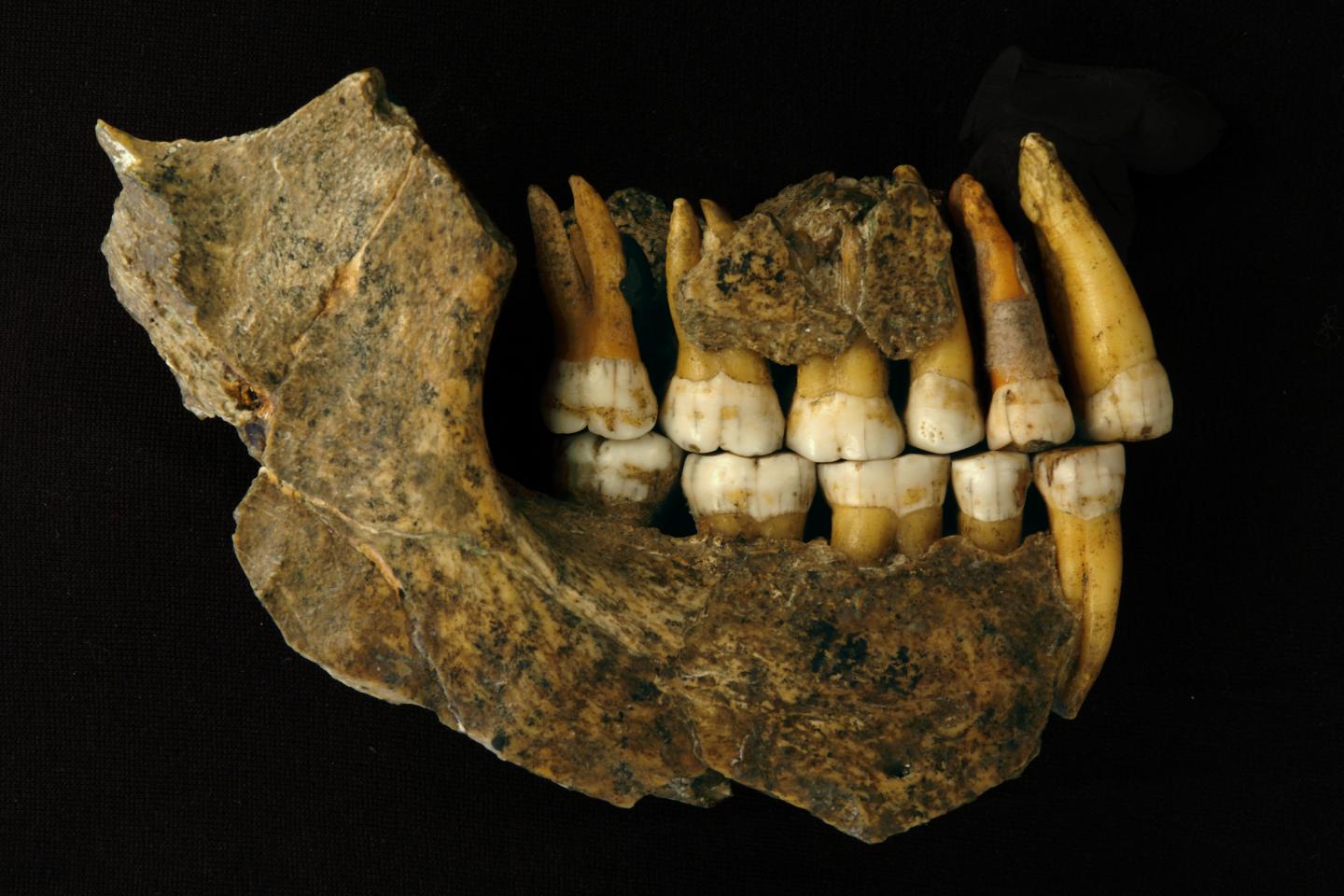
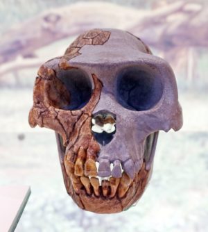
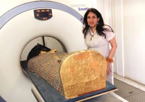
DIAMOND LIGHT SOURCE—In June 2019, an international team brought the complete skull of the 3.67-million-year-old Little Foot Australopithecus skeleton, from South Africa to the UK and achieved unprecedented imaging resolution of its bony structures and dentition in an X-ray synchrotron-based investigation at the UK’s national synchrotron, Diamond Light Source. The X-ray work is highlighted in a new paper in e-Life, published today (2nd March 2021) focusing on the inner craniodental features of Little Foot. The remarkable completeness and great age of the Little Foot skeleton makes it a crucially important specimen in human origins research and a prime candidate for exploring human evolution through high-resolution virtual analysis.
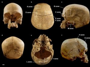
To recover the smallest possible details from a fairly large and very fragile fossil, the team decided to image the skull using synchrotron X-ray micro computed tomography at the I12 beamline at Diamond, revealing new information about human evolution and origins. This paper outlines preliminary results of the X-ray synchrotron-based investigation of the dentition and bones of the skull (i.e., cranial vault and mandible).
Leading author and Principal Investigator, Dr Amelie Beaudet, Department of Archaeology, University of Cambridge and honorary research at the University of the Witwatersrand (Wits University) explains: “We had the unique opportunity to look at the finest details of the craniodental anatomy of the Little Foot skull. While scanning it, we did not know how well the smallest structures would be preserved in this individual, who lived more than 3.5 million years ago. So, when we were finally able to examine the images, we were all very excited and moved to see such intimate details of the life of Little Foot for the first time. The microstructures observed in the enamel indicate that Little Foot suffered through two clear periods of dietary stress or illness when she was a child.”
The team were also able to observe and describe the vascular canals that are enclosed in the compact bone of the mandible. These structures have the potential to reveal a lot about the biomechanics of eating in this individual and its species, but also more broadly about how bone was remodeled in Little Foot. The branching pattern of these canals indicates some remodeling took place, perhaps in response to changes in diet, and that Little Foot died as an older individual.
The team also observed tiny (i.e., less than 1 mm) channels in the braincase that are possibly involved in brain thermoregulation (i.e., how to cool down the brain). Brain size increased dramatically throughout human evolution (about threefold), and, because the brain is very sensitive to temperature change, understanding how temperature regulation evolves is of prime interest. Dr Amelie Beaudet adds: “Traditionally, none of these observations would have been possible without cutting the fossil into very thin slices, but with the application of synchrotron technology there is an exciting new field of virtual histology being developed to explore the fossils of our distant ancestors.”
Dr Thomas Connolley, Principal Beamline Scientist at Diamond commented: “Important aspects of early hominin biology remain debated, or simply unknown. In that context, synchrotron X-ray imaging techniques like microtomography have the potential to non-destructively reveal crucial details on the development, physiology, biomechanics and taxonomy of fossil specimens. Little Foot’s skull was also scanned using the adjacent IMAT neutron instrument at ISIS Neutron and Muon Source, combining X-ray and neutron imaging techniques in one visit to the UK. With such a rich volume of information collected, we’re eager to make more discoveries in the complementary X-ray and neutron tomography scans.”
Applications of X-ray synchrotron-based analytical techniques in evolutionary studies have opened up new avenues in the field of (paleo)anthropology. In particular, X-ray synchrotron microtomography has proved to be enormously useful for observing the smallest anatomical structures in fossils that are traditionally only seen by slicing through the bones and looking at them under a microscope. Through the last decade, there have been more studies in palaeoanthropology using synchrotron radiation to investigate teeth and brain imprints in fossil hominins. However, scanning a complete skull such as the one of Little Foot and aiming to reveal very small details using a very high-resolution was quite challenging, but the team managed to develop a new protocol that made this possible. To recover the smallest possible details from a fairly large and very fragile fossil, the team decided to image the skull using synchrotron X-ray micro computed tomography at the I12 beamline at Diamond.
Principal Investigator, and Associate Professor, Prof Dominic Stratford, University of Witwatersrand (Wits University), School of Geography, Archaeology and Environmental Studies says: “This level of resolution is providing us with remarkably clear evidence of this individual’s life. We think there will also be a hugely significant evolutionary aspect, as studying this fossil in this much detail will help us understand which species she evolved from and how she differs from others found at a similar time in Africa. This is just our first paper so watch this space. Funding permitting, we hope to be able to bring other parts of Little Foot to Diamond,” adding:
“This research was about bringing the best-preserved Australopithecus skull to the best of the best synchrotron facility for our purposes. Traditionally, hominins have been analyzed by measuring and describing by the exterior shapes of their fossilized bones to assess how these differ between species. Synchrotron development and microCT resources means that we are now able to virtually observe structures inside the fossils, which hold a wealth of information. More recently, technology has developed to such an extent that we can now virtually explore minute histological structures in three dimensions, opening new avenues for our research.”
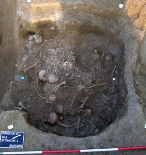
The first bones of the Little Foot fossil were discovered in the Sterkfontein Caves, northwest of Johannesburg, by Professor Ron Clarke of the University of the Witwatersrand in 1994. In 1997, following their discovery of the location of the skeleton, Professor Clarke and his team spent more than 20 years painstakingly removing the skeleton in stages from the concrete-like cave breccia using a small airscribe (a vibrating needle). Following cleaning and reconstructing, the skeleton was publicly unveiled in 2018. Wits University is the custodian of the StW 573, Little Foot, fossil.
Professor Ron Clarke, the British scientist based in South Africa who discovered and excavated Little Foot and conducted all the early examinations of the fossil, was also part of the research team and concludes: “It has taken us 23 years to get to this point. This is an exciting new chapter in Little Foot’s history, and this is only the first paper resulting from her first trip out of Africa. We are constantly uncovering new information from the wealth of new data that was obtained. We hope this endeavor will lead to more funding to continue our work. Our team and PAST* emphasize that all of humanity has had a long-shared ancestry in harmony with the natural world, and that learning from those earliest ancestors gives us perspective on the necessity to conserve nature and our planet.”
This paper is the first in what is expected to be a series of papers resulting from the wealth of data the Principal Investigators from the University of Witwatersrand in South Africa the University of Cambridge in UK, co-investigators from the Natural History Museum and Diamond were able to gain from their collaboration. Little Foot also underwent neutron imaging at STFC’s ISIS Neutron and Muon Source at the same time as the work undertaken at Diamond Light Source, providing unprecedented access to complementary advanced imaging techniques. Neutrons are absorbed very differently from X-rays by the fossil’s interior parts thanks to the sensitivity of neutrons to certain chemical elements. Despite having coarser spatial resolution, neutron tomography can sometimes differentiate between different mineralogical constituents for which contrast is very low for X-rays.
_______________________________

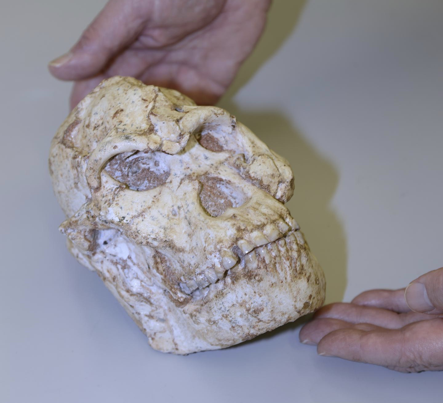
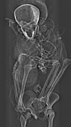
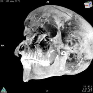
Close-up of Little Foot Skull at Diamond Light Source. Diamond Light Source
________________________
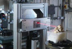
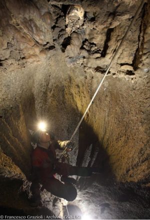
Little Foot Fossil skull in Diamond’s beamline I12. Diamond Light Source Ltd
________________________
*’Preliminary paleohistological observations of the StW 573 Little Foot skull’ – Amelie Beaudet, Robert Atwood, Winfried Kockelmann, Vincent Fernandez, Thomas Connolley, Nghia Trong Vo, Ronald Clarke, Dominic Stratford. DOI: https://doi.org/10.7554/eLife.64804
Article Source: DIAMOND LIGHT SOURCE news release
The team: Principal Investigators, Professor Dominic Stratford and Dr Amelie Beaudet from the University of the Witwatersrand and University of Cambridge respectively, co-investigators Dr Vincent Fernandez, Natural History Museum, Dr Robert Atwood and Dr Nghia Trong Vo, Diamond Light Source, Dr Thomas Connolley, Principle Beamline Scientist, Diamond Light Source and Dr Winfried Kockelmann, the Science and Technology Facilities Council’s ISIS Neutron and Muon Source, Professor Ron Clarke, University of the Witwatersrand, South Africa.
*PAST South Africa (Paleontological Scientific Trust https://www.past.org.za/learn/ ) was set up to fund research into LF and has since funded and facilitated research into literally tons of fossils and excavation project. It has funded numerous research projects on specimens that reveal details of our humanity and our link with nature ‘We are all from Africa’.
For further information please contact Diamond Communications: Lorna Campbell +44 7836 625999 or Isabelle Boscaro-Clarke +44 1235 778130
About Diamond Light Source:
W: http://www.diamond.ac.uk Twitter: @DiamondLightSou
Diamond Light Source provides industrial and academic user communities with access to state-of-the-art analytical tools to enable world-changing science. Shaped like a huge ring, it works like a giant microscope, accelerating electrons to near light speeds, to produce a light 10 billion times brighter than the Sun, which is then directed off into 33 laboratories known as beamlines. In addition to these, Diamond offers access to several integrated laboratories including the world-class Electron Bio-imaging Centre (eBIC) and the Electron Physical Science Imaging Centre (ePSIC).
Diamond serves as an agent of change, addressing 21st century challenges such as disease, clean energy, food security and more. Since operations started, more than 14,000 researchers from both academia and industry have used Diamond to conduct experiments, with the support of approximately 760 world-class staff. More than 10,000 scientific articles have been published by our users and scientists.
Funded by the UK Government through the Science and Technology Facilities Council (STFC), and by the Wellcome Trust, Diamond is one of the most advanced scientific facilities in the world, and its pioneering capabilities are helping to keep the UK at the forefront of scientific research.
About Wits University:
W: http://www.wits.ac.za Twitter: @Wits_News & @WitsUniversity
Wits University is a research-intensive University, one of the leading institutions on the African continent that produces world-class research that is locally relevant and globally competitive. Wits is a global leader in the palaeosciences, one of its key research areas. Wits research output has increased by over 45% in the last four years with more than 85% of its research published in international journals. Wits offers a free space for the exchange of ideas and a vibrant intellectual community that fosters debate and knowledge transfer both within and beyond our lecture halls. Wits latest research available at http://www.wits.ac.za/ research.
About the University of Cambridge
The mission of the University of Cambridge is to contribute to society through the pursuit of education, learning and research at the highest international levels of excellence. To date, 110 affiliates of the University have won the Nobel Prize.
Founded in 1209, the University comprises 31 autonomous Colleges and 150 departments, faculties and institutions. Cambridge is a global university. Its 19,000 student body includes 3,700 international students from 120 countries. Cambridge researchers collaborate with colleagues worldwide, and the University has established larger-scale partnerships in Asia, Africa and America.
The University sits at the heart of the Cambridge cluster, which employs more than 61,000 people and has in excess of £15 billion in turnover generated annually by the 5,000 knowledge-intensive firms in and around the city. The city publishes 316 patents per 100,000 residents. http://www.cam.ac.uk
Twitter: @Cambridge_Uni @UCamArchaeology
About the Science and Technology Facilities Council’s ISIS Neutron and Muon Source
W: https://stfc.ukri.org T: https://twitter.com/stfc_matters
ISIS Neutron and Muon Source produces beams of neutrons and muons that allow scientists to study materials at the atomic level using a suite of instruments, often described as ‘super-microscopes’. It supports a national and international community of more than 2000 scientists who use neutrons and muons for research in physics, chemistry, materials science, geology, engineering, and biology.
ISIS Neutron and Muon Source is a world-leading centre for research in the physical and life sciences. It is owned and operated by the Science and Technology Facilities Council.
The Science and Technology Facilities Council is part of UK Research and Innovation; the UK body which works in partnership with universities, research organisations, businesses, charities, and government to create the best possible environment for research and innovation to flourish. STFC funds and supports research in particle and nuclear physics, astronomy, gravitational research and astrophysics, and space science and also operates a network of five national laboratories as well as supporting UK research at a number of international research facilities including CERN, FERMILAB and the ESO telescopes in Chile.
_________________________________
Advertisement


