
AMERICAN ASSOCIATION FOR THE ADVANCEMENT OF SCIENCE (AAAS)—The population of Rapa Nui before European contact was far smaller than thought, a new analysis* of historic subsistence farming practices on the island finds. Results indicate the agricultural system could sustain less than 4,000 people – a number well below the 17,000 proposed by earlier research. The work challenges the theory that pre-contact Rapa Nui communities outgrew their resources and suffered ecological and social collapse. “Contrary to popularized narratives about a runaway population size that overexploited natural resources, our results suggest that significant demographic increases (“overshoot”) did not occur in the past,” Dylan Davis and colleagues write. Rapa Nui is a little under 164 square kilometers (km2) and, as such, has finite natural resources. Before European contact in the early 1700s, communities on the island used rock gardening to increase soil productivity. This strategy layered fist-sized rocks, broken rocks, and bigger boulder rocks on soil to prevent moisture loss and reduce nutrient leaching. Past work estimated that rock gardens took up 4.9 to 21.1 km2 of the island, sustaining up to 17,000 people. These estimates boosted the idea that people drained Rapa Nui’s limited resources through exploitative farming and overshot its carrying capacity. However, Davis et al.’s new study argues that the maximum number of people on Rapa Nui was only ever near 3,901. Using 5 years of high-resolution shortwave infrared and near-infrared data obtained by satellite, the team searched for archaeological sites of rock gardening, identifiable by distinct patterns of vegetation and soil composition. Their machine learning-based analyses showed that rock gardens took up only 0.76 km2 of land and that the practice alone could have supported just around 2,000 people. If accounting for marine food sourcing and foraging, the island could have held a little under 4,000. “Prior estimates were between 5 and 20 times too high,” the authors conclude. “The extent of rock gardening cultivation found in the occupied coastal areas comports with estimates of the population from observations made by early European visitors.”
____________________________
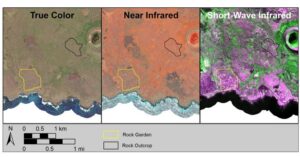
Visual comparison between true color imagery (what humans can see by eye), near-infrared imagery (commonly used for vegetation mapping), and short-wave infared (which can identify moisture content variation and minerals in soil). Rock gardens are most visible when looking at the short-wave infared imagery. Satellite imagery courtesy of Maxar. Map created by Dylan Davis
____________________________
Article Source: AMERICAN ASSOCIATION FOR THE ADVANCEMENT OF SCIENCE (AAAS) news release.
*Island-wide characterization of agricultural production challenges the demographic collapse hypothesis for Rapa Nui (Easter Island), Science Advances, 21-Jun-2024. www.science.org/doi/10.1126/sciadv.ado1459
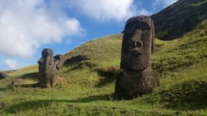
Cover Image, Top Left: SoniaJane, Pixabay
______________________________
Advertisement


