
Other than cities, towns, and road systems, what we see today on the eastern mid-Atlantic U.S. landscape is quite different than what Native Americans saw before European contact. It was a world that essentially vanished as colonizers took root and transformed their environment to meet their needs. This is nothing new to most historians.
Thanks to recent research, however, scientists can now reconstruct that landscape with accuracy, providing information that may also help manage the environment of today.
It all has to do with milldams and leaves. According to a team of geoscientists, sediment behind milldams in Pennsylvania preserved leaves deposited just before European contact, providing a glimpse of ancient forests. To get to this, they examined samples of 300-year-old leaves buried by sediment backed up behind Denlinger’s Mill in Lancaster County. The leaves fell from trees from above the location of the dam. As sediment rapidly covered and “entombed” the leaf layer, the leaves that were deposited before the construction of the dam were preserved intact.
“First we had to uncover the leaf mats and then try to get a sample,” said Sara J. Elliott, a research associate at the University of Texas Austin, Bureau of Economic Geology. “The mats were fragile and delicate, and getting them back to the lab or just transferring them from one container to another was problematic.”
But Elliott carefully and successfully peeled away the leaves, layered on top of each other in mud and preserved in remarkable detail. She then treated them in a variety of chemical baths, mounted them between large glass slides and cataloged the various species.
Analysis of the results led to a surprising conclusion.
“We expected to see evidence for single stream channels that meandered back and forth across the valley bottom landscape for millennia, ” wrote researcher Dorothy J. Merritts, chair, Department of Earth and Environment, and colleagues. “Instead, we found that most of the valley bottoms at the time of European contact were dominated by wetland ecosystems with numerous small, stable ‘anastomosing’ streams.” These branching and reconnecting streams were far different from the steep-banked meandering streams that, since the dams were breached, now cut through the silt deposits created by the dams.
________________________________________________________________________________________________________________________
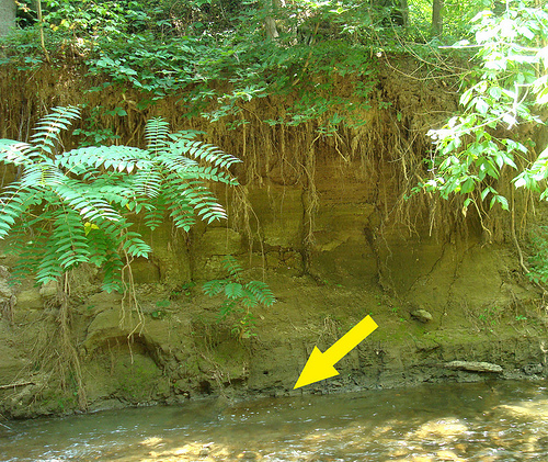
Above shows Denlinger’s Mill study site. Located on the West Branch of the Little Conestoga Creek in Lancaster County, PA. Arrow indicates dark paleo-wetland soil layer containing fossil leaf deposits, with four plus meters of historical sediment buildup on top. Credit: Penn State
_______________________________________________________________________________________________________________________
“Milldams were built from the late 1600s to the late 1800s in Pennsylvania and other parts of the east,” said Peter Wilf, professor of geosciences, Penn State University. “We can’t get information from historic records on what the area looked like before the dams because recording of natural history didn’t really begin until the 1730s and was not detailed.”
U.S. census shows that by 1840, tens of thousands of milldams existed in the mid-Atlantic region. About 10,000 of these were in Pennsylvania. In Lancaster County, estimates were one dam for every mile of stream. The abundance of dams in the area altered the landscape dramatically, according to the researchers.
The Denlinger’s Mill site is unusual because of the rock outcrop and the trees that have grown there over the water. The leaves found in the stream bank preserve a snapshot of the trees growing directly above before European settlement, which consisted overwhelmingly of American beech, red oak and sweet birch, similar to modern red oak/beech forests today. But box elder and another maple dominate the current forest that grows above the stream.
“It was intriguing to see samples from American chestnut, which isn’t around anymore because of the chestnut blight,” said Elliott. “On the whole though, the species are around today, just in different proportions and places.”
_______________________________________________________________________________________________________________________
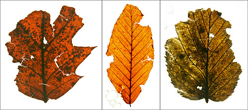
Above shows dominant components of the pre-European settlement forest. Red Oak (left), American Beech (center), Sweet Birch (right). These are fossil leaves removed from the Denlinger Mill study site. Credit: Penn State
_______________________________________________________________________________________________________________________

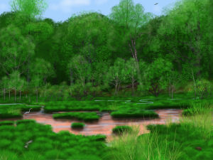
This is an artist’s reconstruction of the pre-settlement landscape. The upper slope forest community in the background represents the Red Oak-American Beech-Sweet Birch mixed hardwood forest interpreted here from fossil leaves. The foreground consists of tussock-sedge wetlands with small, interconnected stream channels and pools, quite unlike the steep-banked single channel streams seen today. Credit: Penn State
_____________________________________________________________________________________________________________________
The scientists see a potential application of their findings to addressing some environmental problems of today.
“We now know that legacy sediment from the stream banks caused by the milldams is the major source of eutrophication in the Chesapeake area,” said Wilf. “Not, as is usually assumed, modern agricultural runoff.” Establishment of precolonial-like habitats might decrease the amounts of nutrients from the legacy sediments that currently flow into the Chesapeake watershed and cause increased algal and plant growth.
The findings are published in the November 13th issue of PLOS ONE.
___________________________
Source: Adapted and edited from a press release of Penn State.
___________________________
Cover Photo, Top Left: Artist’s reconstruction of the pre-settlement landscape. The upper slope forest community in the background represents the Red Oak-American Beech-Sweet Birch mixed hardwood forest interpreted here from fossil leaves. The foreground consists of tussock-sedge wetlands with small, interconnected stream channels and pools, quite unlike the steep-banked single channel streams seen today. Credit: Penn State
________________________________________________________________________________________________________________________
Read about the most fascinating discoveries with a premium subscription to Popular Archaeology Magazine. Find out what Popular Archaeology Magazine is all about. AND MORE:
 Popular Archaeology’s annual Discovery edition is a selection of the best stories published in Popular Archaeology Magazine in past issues, with an emphasis on some of the most significant, groundbreaking, or fascinating discoveries in the fields of archaeology and paleoanthropology and related fields. At least some of the articles have been updated or revised specifically for the Discovery edition. We can confidently say that there is no other single issue of an archaeology-related magazine, paper print or online, that contains as much major feature article content as this one. The latest issue, volume 2, has just been released. Go to the Discovery edition page for more information.
Subscription Price: A very affordable $5.75 for those who are not already premium subscribers of Popular Archaeology Magazine (It is FREE for premium subscribers to Popular Archaeology). Premium subscribers should email [email protected] and request the special coupon code. Or, for the e-Book version, it can be purchased for only $3.99 at Amazon.com.


