
Naxos is the largest island in the Greek Cycladic group, located in the Aegean Sea between the Greek and Turkish mainlands. The islands’ varied landscapes combine to give it a special character. Known for its rich land and bountiful crops as well as for its beautiful white marble and abrasive emery, I could make a journey from a sandy beach to a leafy mountain village in about an hour. Wherever I looked my eye found archaeological treasure and history: from Classical temples to Byzantine architecture. It was also all around me as I made my way through the peaceful Naxian villages and towns. The winding medieval lanes of central Chora are perfect examples of places where one is completely immersed in a medieval town-scape with a view: from the top of the medieval Venetian kastro (castle) the Classical temple of Apollo can be seen across the harbor. However, less known to the world, recent archaeological excavations on Naxos have revealed a far older prehistoric legacy on this island.
Beginning in 2013, an international team led by Dr. Tristan Carter of McMaster University through the Canadian Institute in Greece, and his co-director Dr. Demetris Athanasoulis of the Cycladic Ephorate of Antiquities of the Hellenic Republic’s Ministry of Culture and Sports, has conducted a series of ongoing excavations at what is currently the earliest known archaeological site in the Cycladic region. Located on Stélida hill on a promontory that juts out into the Aegean Sea, archaeologists and student volunteers of the Stélida Naxos Archaeological Project (SNAP) have uncovered a wealth of lithic (stone) material suggesting that Stélida was a place used to acquire raw material to form stone tools as long ago as at least two hundred thousand years.
Digging Up an Ancient Quarry
In the summer of 2016 I spent a month with the SNAP team at Stélida as part of my Global Archaeology project. Standing at its summit, I could view the coastline and the sea spreading out before me toward the west. I could clearly see Naxos’s hilly neighboring island, Paros, across a short distance of water. The area is very dry, and the visual contrast between the dry yellow earth and vegetation and the vivid turquoise sea is striking. But what drew me to Stélida was not the view—it was the stone beneath my feet. Stélida was first identified as a significant source of chert in 1981 as part of a survey by the École Française d’Athènes under the direction of René Treuil. Chert is fine grained sedimentary rock that was commonly used in prehistory by hominins and anatomically modern humans for producing stone tools and weapons. SNAP excavation trenches are located on different parts of the hillside, with two archaeologists working at each trench. Every morning of the excavation season the team begins the daily climb from the bottom of the hill and ascends the 118 m hill to their designated trenches. The path is literally littered with lithics – stepping on archaeological material is impossible to avoid at Stélida. By spreading the team across a large area, many different aspects of the prehistoric activities once carried out there can be investigated simultaneously and a more informed picture of the use of this landscape can be developed. This has also allowed the team to refine their research focus over time and explore specific areas of the hillside that are producing particular diagnostic types of lithics — stone material modified by hominins or early humans that are telling us something about when they were made and their material culture.
In 2016, SNAP was focused on opening a few new excavation trenches at the very base of the hill and towards the summit, as well as revisiting some that had been opened the previous year. I was tasked with opening and excavating a new 2m x 2m trench about ¾ of the way up the hill, positioned immediately at the base of a substantial chert outcrop. Without contest this is the most artifact-rich site I have ever excavated. The downside of such a rich site is that what I was excavating was mostly stone – not an easy material through which to shovel. We quickly developed a working rhythm with the passing of time, marked by the ferries sailing past us through the channel between our island, Naxos, and neighboring Paros. It seemed to be a contradistinction to be doing hard labor at a location surrounded by holiday villas and resorts where vacationers were being pampered. Our reward: only the archaeologists were afforded a view of the beautiful sunrise over the Aegean every morning from the top of Stélida hill.
__________________________

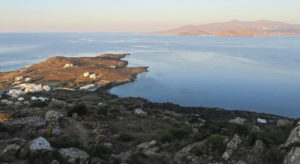
Stélida as viewed from the north on Naxos. D. Depnering
__________________________
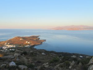
View from Stélida toward the sea. Kate Leonard
__________________________
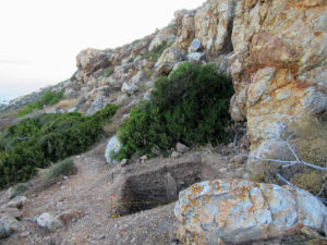
The 2016 excavation trench. Kate Leonard
__________________________
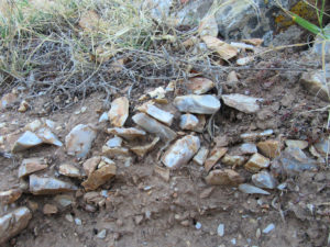
Stone tools and other lithics in situ at Stélida. Kate Leonard
__________________________
New Data, New Insights
More recently, the SNAP team has focused on evidence from a particular excavation trench — DG-A/001 — laid out toward the summit on the western side of the hill on a debris cone at the base of a chert outcrop. The 2 m by 2 m excavation trench was dug to a depth of 3.8 m through stratified colluvial deposits — translated, this means the excavators dug twice the height of a tall man through sediment and stone that had both originated at that specific location and washed down the slope from the summit over hundreds of thousands of years. This is tough work through mostly stone compressed in a matrix of soil – not the type of excavation that uses brushes to expose delicate surfaces. In the process, excavators revealed more buried prehistoric soil layers. Using infrared stimulated luminescence dating, a technique used to measure the time elapsed since the last exposure of soil samples to sunlight, levels were dated from 13.8-12.1 thousand years ago toward the top of the trench to 219.9-189.3 thousand years ago toward the bottom of the trench. From this trench, approximately 12,000 artifacts were excavated and over 9,000 of those were in strata (layers or levels) dated to the Pleistocene. The diagnostic lithics (stone objects indicative of particular time periods and/or cultural groups) found in DG-A/001 included Upper Palaeolithic tools — usually associated with modern humans, or Homo sapiens — Middle Palaeolithic technologies (such as Mousterian — usually associated with Neanderthals ), and examples of Mediterranean tool-making traditions from the early Middle to Lower Palaeolithic. Middle and Lower Paleolithic activity at Stélida was also evident in 159 diagnostic artifacts previously identified during surface surveys on the hillside.
The calcareous soil at Stélida was not conducive to the preservation of organic materials and so the excavators worked down through layer upon layer of mostly stone flakes, cores and debitage. When I dug with SNAP, for more than a meter below the modern ground surface the material I was excavating was over half composed of lithic debitage. In terms of volume of artifacts vs. non-artifacts, Stélida is by far the most artifact-rich site I have ever excavated. Like many prehistoric and historic quarry sites the artifacts that were uncovered at Stélida represent the early stages in the production of stone tools and as such the excavation team did not uncover many easily identified stone tools like those that would be found on a habitation site. The majority of what they uncovered was the material evidence of stone extraction and reduction activities. The team was digging through the evidence of quarrying (extraction) and the initial formation of pieces like rough cores (reduction). From the type of lithic material that was found in the excavations at Stélida it can thus be assumed that the higher quality pieces of chert were selected and taken elsewhere by the ancient toolmakers for final processing and use.
While much of the lithics excavated from Stélida are not easily discernible artifact types and analysis is often done of material from the early stages of the reduction process, there have nonetheless been some diagnostically identifiable types excavated from well-sealed and dated contexts. Some of the lithics from Stélida are consistent in their form and modification with artifacts from other well-dated Mesolithic and Lower to Upper Palaeolithic sites in Greece and Anatolia. There is also known Middle Palaeolithic activity at Stélida identified from diagnostic prepared core technology. This means that some of the anthropogenic (human-modified) material found here can be securely dated to the time when Neanderthals were living in Europe. But what the newly published evidence from Stélida tells us is that it is possible there were other hominid species quarrying and using Stélida chert even earlier. For instance, there is potential evidence for Lower Palaeolithic activity at Stélida in the form of possible bifaces that could be interpreted as handaxes. It is plausible that these large heavy tools could have been made by Homo heidelbergensis, the predecessor of the Neanderthals in Europe. The possibility for evidence of these early hominids living on what are now the Cycladic Islands has not been seriously investigated before—until now.
Activity Patterns and Behavior
As an archaeologist, I was interested in knowing if the SNAP team had come across any patterns in the evidence they were revealing. Were similar types of artifacts found in the different trenches? Or do the artifacts suggest different periods of use in different areas of the Stélida hillside? As I corresponded with Carter, he told me that “for the most part we [the SNAP project team] seem to be finding a lot of similar stuff across the site” but noted, however, that “there are some greater concentrations of certain periods”. So the team has identified that generally, similar types of lithic material are found across the hillside, with some concentrations demonstrating more intensive use at certain locations during certain periods. For instance, surface surveys have uncovered more Middle and Lower Palaeolithic material from the areas toward the summit of the hill in front of two identified rock shelters and in the vicinity of the coast at the bottom of the hill, than in other areas. From the evidence uncovered in the excavation trenches the Mesolithic is best represented by the materials uncovered at the top of the Stélida hill, Upper Palaeolithic material is found “everywhere”, and Middle Palaeolithic evidence found below the summit and in the middle of the hill’s slope (although intermixed with later material). Interestingly, the loose concentration of excavated Middle Palaeolithic material comes from an area associated with both a rock shelter and an ancient spring.
Carter revealed another fascinating observation. “The work of my colleague Dr. Dora Moutsiou suggests that there are hints of raw material preferences through time.”—With this statement, he suggests that the evidence from Stélida may show that particular types of chert may have been preferred by different hominins at different times. Middle Palaeolithic materials are more often the slightly grainy grey and orange cherts sourced from around Stélida’s Rock Shelter A (basically an area of collapsed rocks upslope from a spring) and further north on the hill, while the Upper Palaeolithic and Mesolithic materials are more often made of the lustrous white-blue chert sourced from the southern summit of Stélida. The suggestion therefore is that when they visited Stélida to quarry, Neanderthals were looking for grainy grey-orange chert and, later, Homo sapiens were looking for smooth white-blue chert. Perhaps this was part of the prehistoric oral history of Stélida – passing down through generations not only what the landscape was like and how to get there, but what sort of stone tool making materials would be found once they arrived.
The assemblage excavated by SNAP from Stélida is comprised exclusively of lithics due to the highly alkaline nature of the hills’ calcareous soil. The only location so far excavated by SNAP that may produce information about any organic presence on the hillside in the prehistoric period comes from a trench located in front of Rock Shelter B. But Carter clarified for me that “we are not permitted at present to excavate inside the two shelters […] as that falls under jurisdiction of a different bureau of the Greek Ministry of Culture”. The trench just outside of Rock Shelter B contained traces of in situ hearths that may be of Upper Palaeolithic date. According to Carter the fauna from this context is microscopic and is being investigated by a specialist in sedimentary aDNA analysis (a technique to identify evidence of animals and plants via extracted traces of aDNA from soil samples) at the McMaster University ancient DNA laboratory. It is hoped that this innovative technique will expose another facet of what the environment was like at Stélida in the Palaeolithic. Tantalizingly, Carter stated that some of the plant remains from the potential hearths “might be material for matting [or] fuel”. There will be more to come on this once the data is published.
__________________________
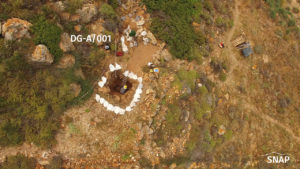
Aerial view of Trench DG-A/001 (or ‘Trench 1’). Evaggelos Tzoumenekas
__________________________
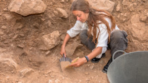
Team member Irina Kajtez (Belgrade University) excavating Trench 1 (DG-A/001) in 2015. Rachit Srivastava
__________________________
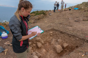
Shannon Crewson (McMaster University undergraduate in 2015) documenting the excavation of Trench 3 (DG-A/003) in 2015. Rachit Srivastava
__________________________

Ioanna Aslamatzidi (undergraduate Athens University) and Hanna Erftenbeck (PhD candidate Note Dame University) screen for finds on Stelida, 2017. Jason Lau
__________________________
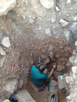
Justin Holcomb (co-author and PhD candidate Boston University) takes and prepares a soil sample from the lower levels of DG-A/001 (‘Trench 1’) for micromorphological studies to understand the development of the deep archaeological sequence. Jason Lau
__________________________
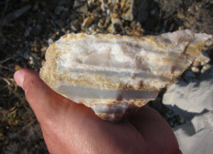
Geological hand sample of Stelida chert. Nikos Skarpelis
__________________________

Beatrice Fletcher (PhD candidate McMaster University) studies a stone tool from the excavations, 2015. Rachit Srivastava
__________________________
Implications: A Shifting Paradigm
When the Stélida area was first reached by hominins the landscape would have been much different than what we see today. Scientific investigations into the ancient environment suggest that the modern islands of Naxos and Paros were joined with others as part of one great island known as the ‘Cycladean Island’ during the glacial maximum (the stage of the Ice Age when the maximum amount of sea water was trapped in glaciers). Paleogeographic reconstructions of the area indicate that during the interglacial periods of the Quarternary (the time period from 2.59 million years ago to the present), sea levels may have been low enough to expose a land bridge between the Greek and Anatolian peninsulas that would have resembled a wetland environment rich in resources. One can envision that tens of thousands of years ago when hominins and anatomically modern humans climbed the hill at Stélida to reach the chert outcrops they would have been looking out over a green, grassy plain, an estuary or even a lagoon, with the sea many kilometers away. It is likely that they were not only attracted to the great Cycladean Island for the Naxian emery, chert at Stélida, or the basalt and obsidian of the nearby island of Melos, but equally for the hunting and foraging opportunities provided by the surrounding wetland environment.
The average person with an average lifespan would find it difficult to fathom a time span of 1 million years. This is the amount of time that has passed since hominins first moved into Europe from Africa, during the Lower Palaeolithic and before anatomically modern humans had even evolved. There is no current way to know if Stélida or somewhere else in the vicinity was a location used for long-term habitation during the Palaeolithic. Due to the nature of the site and the material record available for dating, precise dates for the exploitation events at the chert source are not possible. It is unclear whether the use of the site in the Lower to Middle Paleolithic was intermittent, opportunistic or consistent. Nevertheless, the archaeological material being uncovered suggests that Stélida was a place hominins and anatomically modern humans came back to again and again to extract chert. The question remains: how did they get there?
Early Mariners?
It has always been assumed that these early hominin explorers of Europe were not able to make boats (even the most basic) and so could never have traversed large bodies of water like seas. However, the current evidence from the Palaeolithic environment models tell us that there would not have been large bodies of water to cross in the region of Naxos. At worst, the crossings would have been much smaller, with hominins likely seeing the next landfall within sight of their point of origin. Tides would still have had an effect and at different periods in prehistory the depth and width of the water being crossed would have varied depending on the total glaciation. If water crossing was necessary (as opposed to land bridges) the craft fashioned by the early quarriers may not have resembled what we think of as boats today, but clearly they were effective in allowing Stélida to be accessed again and again for hundreds of thousands of years. The results from SNAP can therefore be described as ground-breaking evidence for alternative route-ways for Homo sapiens and their ancient predecessors’ movements from Asia into Europe.
With this, the possibility of pre-sapiens accessing locations like Stélida triggers a new understanding of what these hominins may have been capable of cognitively. This includes the capacity to communicate complex ideas through shared language, perhaps the construction of vessels to carry them across bodies of water, an understanding of the moon and tides, likely the ability to identify landmarks and return to a site previously visited and/or to follow directions passed on from another, and the ability to navigate a landscape and environment quite different from those elsewhere in Eurasia. To support such a fundamental shift in our understanding of pre-sapien hominin capabilities, a robust data set and sample size that can be scientifically dated from a clearly stratified excavation, like Stélida, is required.
The SNAP excavations and analysis has revealed the first stratified, large, and well-dated Pleistocene lithic assemblage from the Cyclades that allows for the assertion that hominin and anatomically modern human dispersals into Europe traversed through areas, like the Aegean Basin, that have been previously viewed as inaccessible. The team suggests that instead of a single route into Europe from the Anatolian peninsula it is more likely that pre-sapiens and anatomically modern humans took a variety of routes for a variety of reasons. Until now there has been no robust evidence for Middle Pleistocene cultural activity in the central Aegean; Neanderthals and earlier hominins were thought to have been present only on either side of the region, continental Greece and the Anatolian peninsula. Now, new evidence suggests that the Aegean Basin region was open for consistent use by hominins throughout the Palaeolithic.
_____________________________
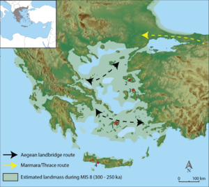
Location of Stélida archaeological site and hypothesized hominin dispersal routes: 1, Stelida; 2, Rodafnidia; 3, Karaburun; and 4, Plakias. Base map modified from Lykousis 2009 (22). Figure by J.H.
_____________________________
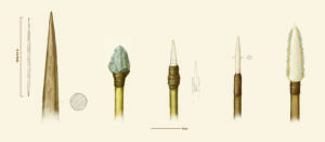
Reconstruction of prehistoric spearheads hypothesized to have been made from stone material at Stélida – of Lower, Middle and Upper Palaeolithic, plus Mesolithic date (L-R). Kathryn Killackey
_____________________________
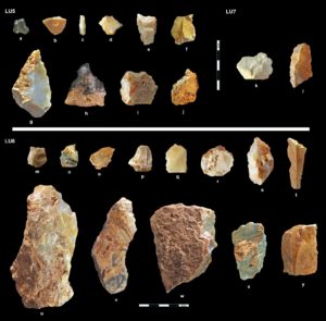
Select artifacts from Stélida. Flakes unless otherwise noted. a, scraper; b, backed flake; c, bladelet; d, piercer; e, piercer on blade-like flake; f, piercer; g, combined tool (burin and scraper on chunk); h, nosed scraper; i, combined tool (inverse scraper/denticulate/notch); j, denticulate (LU5); k, flake; l, denticulated blade-like flake (LU7); m, piercer; n, denticulate; o, denticulate; p, piercer; q, combined tool (linear retouch/denticulate); r, scraper; s, convergent denticulate (Tayac point); t, blade; u, scraper; v, denticulate; w, linear retouch; x, tranchet; and y, blade-like flake (LU6). Photographed by J. Lau and modified and page set by N. Thompson.
_____________________________
Moving Forward
The SNAP team will be returning to Stélida for another season of excavation in 2020, with continued support from the Canadian Institute in Greece for a new five-year research permit from the Greek Ministry of Culture. Carter plans to return to some very deep (4.5 m) trenches that were opened in previous seasons to obtain further dates, and to start some new excavation trenches in areas of the hillside that may contain less disturbed deposits. The positioning of the new trenches is based on a detailed topographic analysis, says Carter: “We used drone photography to produce a 5 cm resolution digital elevation model and using that with GIS to reconstruct micro-watersheds, and interrogate artifact distribution”. Further work will also be done at the summit of Stélida, but Carter is currently tight-lipped about additional new discoveries the team has been making there — a clue that Stélida will continue to reveal new boundary-pushing evidence of early hominin and anatomically modern human activity in the Aegean.
Read the latest report on the Stélida excavations in Science Advances.
___________________________
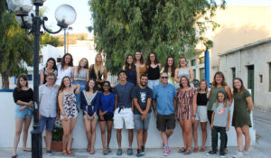
SNAP team photo 2019, with young scholars and students from Canada, Greece, England, France, Serbia and the US. Valerie Seferis
___________________________


One comment on “Rewriting Prehistory at Stélida”