It would not be inaccurate to say that most archaeologists spend much of their lives within the narrow parameters defined by chosen areas of specialization. Some have even spent most of their entire careers focusing on a single archaeological site and what the site says about its particular corner of history and culture. Put together, the sum of these efforts and experiences across the world can paint a fascinating mosaic of our past, while raising a barrage of new questions at the same time.
At times some archaeologists, however, have chosen to deal with the broad brush of archaeological inquiry. For a variety of reasons, they elect to stand back and view the entire panorama of discovery and research, whether it is for the purpose of writing a book or teaching a class.
A few may even travel the world to do this.
Kate Leonard, an adventurous Canadian archaeologist, did just that. Beginning in January, 2016, she embarked on a global journey to twelve different destinations in 12 months to explore and reveal a taste of the vast variety of digs and research going on across the globe. Calling it the “Year of Digs”, or Global Archaeology Year, she created a website and blog to document and publicize her journey, bringing the world of archaeology across the world, as she hopped from one destination to another, to the smartphones, tablets and laptops of thousands of readers, young and old. Popular Archaeology also followed her on that journey with a series of articles.
Here is a final interview of Kate, capping what for her and many of her readers was a truly unique learning experience in the world of archaeology, beginning with her first stop in New Zealand and ending in Switzerland:
Questions: What unique or interesting experiences did you encounter or acquire (people, places, events) that you think are worth noting; what is the significance and impact (potential or real) of the work being done; and, what have you learned from this that you did not know or experience before?
New Zealand
On my first stop, I excavated Maori horticultural sites that likely date to before the arrival of Europeans in New Zealand. The types of features we were encountering were: kumara storage pits and structures, borrow pits (large pits dug by the Maori to remove sand beneath the natural subsoil to help them mix and cultivate their soils for horticulture), fire pits and post-holes. The two sites I worked on were located in the Bay of Plenty region and in the Waikato region of the North Island. My tasks were to excavate and record archaeological features in advance of infrastructural development. This involved investigating features to see if they were archaeological, excavating half of the feature if it was archaeological and then recording it through photographs, soil samples, plans and context sheets. Another major component of the excavations was working closely with iwi monitors to ensure an atmosphere of mutual understanding and respect.
In New Zealand all archaeological excavations are monitored by a member of the local iwi. In the Bay of Plenty region the iwi monitor was an elder of that community and was there to observe and comment. In the Waikato the iwi decided to have four members involved on a rotating basis and interact directly with the archaeologists to learn about the process of doing archaeology and what we were finding on the site. This was a very exciting and enriching experience for me because I learned more about the archaeology I was excavating through explaining the methodology behind it and hearing about the cultural practices that the archaeology reflects. I was also able to discuss the current political and cultural situation of the Maori people and how this has changed over the past 20 years (for the better). When you are working with another person in close proximity, for instance excavating a small archaeological feature together, it is easy to allow the conversation to flow and not feel forced like it could in a formal situation like an interview.
In the case of the Bay of Plenty, this is the first time that archaeology has been recorded on that ridgeline, even though it is a residential area full of houses. For the local iwi the discovery of so much archaeology on that small strip of land confirms what their oral history already says. They now know the physical evidence of Maori occupation of that location. In the Waikato the impact is different but no less significant. By exposing members of the local iwi to the basics of archaeology the mystery surrounding what archaeologists are doing is removed. Since archaeologists have to work closely with the iwi when they are developing excavation plans this helps both sides to understand what is required and why. It also adds an additional dimension to the Maori understanding of their past and how daily activities like horticulture were practiced hundreds of years ago.
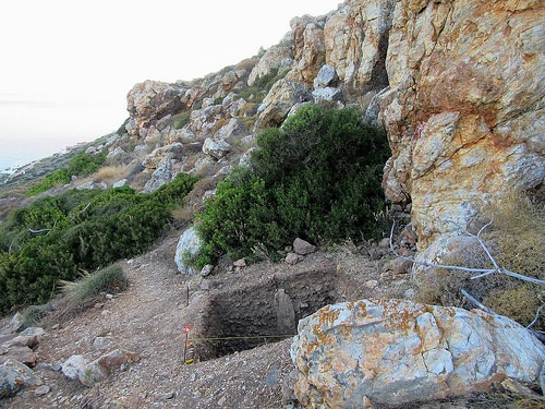
I was not prepared for the sheer scale of some of the archaeological features we would be excavating. In the Waikato some of the borrow pits were 8m by 4m and over 2m deep. I had also not understood the level of complexity behind Maori horticultural practices and how much they had to augment the soils of New Zealand in order to grow the crops they brought with them from Polynesia. These practices were labor intensive and would have required an in-depth knowledge of their crops and how to manufacture soils to suit them.
For More See: https://popular-archaeology.com/issue/summer-2017/article/on-the-global-trail1
Image: Waikato borrow pit under excavation. Courtesy Kate Leonard
Australia
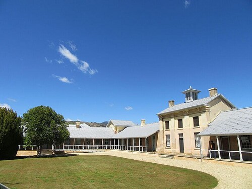
Willow Court is a large complex of buildings that functioned as a mental health institution from 1827 to 2000. It was originally named the New Norfolk Insane Asylum and was built to care for convicts transported to Tasmania by the British Government (then known as Van Diemens Land). I joined the archaeological team and field school being run at Willow Court by Dr. Heather Burke of Flinder’s University. The field school focused mainly on the exercise yard outside of Ward C, the original Barracks building and the contemporary Superintendents cottage, Frescati House.
The main goal for the field school was to lay the groundwork for the excavations due to take place the next season. Specifically, mapping the institutional complex with a total station, doing geophysical surveys to identify sub-soil features and cataloguing artifacts in storage. One objective was to discern what artifacts and materials were retained since 1960, the processes involved in that retention, and what has been lost since. A complete archaeological recording of Frescati House was also in order to help the team and interest groups understand the construction pattern of the house as well as to record it. There was no good spatial data of the Willow Court complex or Frescati House so creating a comprehensive digital plan of the exterior areas (where future excavations may take place) was very important. The three types of geophysical equipment used were ground penetrating radar, an electrical resistivity device and a magnetic gradiometer. It is hoped that the results of the geophys will help the team to target areas to excavate next season.
As you can imagine the local community of New Norfolk has to grapple with stigmatization due to the legacy of this type of institution operating for 170 years. The future of the Willow Court institutional complex is therefore a sensitive and contested issue. On a positive note, the archaeological investigations being conducted here should help all the stakeholders to understand the current state of the site and the artifacts associated with it. With that information hopefully a productive solution that suits all parties can be developed. There have been arguments since the 1960’s about turning the site into a museum or at least preserving it, however nothing has ever developed. As a result the site has fallen into disrepair and is a favorite spot for local teenagers to vandalize. Without cataloguing the known material no plan can be developed to move forward with the future of Willow Court, so it was of the utmost importance that each object be catalogued and documented properly.
Although I was aware of Australia’s Convict Era and had some general knowledge of the severity of the penal system in place, the mental health repercussions had never crossed my mind. The journey in convict ships, physical punishment and mental punishment (such as solitary and silent confinement of prisoners in places like Port Arthur and Cascades Female Factory), and forced hard labor tested the limits of all the convicts minds and some were irreparably damaged by their experiences. Willow Court remained an important institution long after the Convict Era and that should serve to remind us that mental health affects all human populations in all time periods.
For More See: https://popular-archaeology.com/issue/summer-2017/article/archaeologists-investigate-early-19th-century-asylum-of-old-tasmania
Image: The barracked bulding of Williow Court as it appears today. Courtesy K. Leonard
Fiji
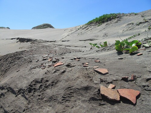
The Archaeological Department of the Fiji Museum conducts Archaeological Impact Assessments (AIA’s) prior to the commencement of development projects (like the building of a resort) and in response to community requests. Communities often request AIA’s to be conducted on cultural significant sites that they perceive to be under threat (for instance by resort expansion) and that they would like to be protected by the government. Due to Cyclone Winston the fieldwork we conducted was directly associated with post-cyclone damage assessment. We traveled west from Suva to Nadi doing Archaeological Impact Assessments for communities and developers. We also conducted some post-cyclone assessments for national heritage sites like the Sigatoka Sand Dunes (where we had to do an unanticipated rescue lift of two human skeletons) and some WWII sites in Suva, and for a community administered site, the Tavuni Hill Fort. I was exposed to the full spectrum of Fijian archaeology in terms of both chronology and site type including Bourewa, site of the earliest known settlement in Fiji (c. 3100BP) and Momi Battery, a WWII gun emplacement site run by the National Trust of Fiji.
The physical challenges to doing fieldwork in Fiji are the heat, humidity and mosquitoes. Dengue fever is also a concern, especially after a violent storm like a cyclone that leaves a lot of standing water. The pace of work is also very different from what I am accustomed to as a North American. There are certain protocols and sequences of interaction that must be followed in order to be considered polite. Essentially this entails discussions and gifting that lead up to the actual fieldwork, time during which most ‘westerners’ would be ‘chomping at the bit’ to get started. However, this aspect is very important to Fijians and it is considered disrespectful to do otherwise. When archaeologists go out into the field to conduct work they must first visit the village associated with the land/archaeological site they are interested in, and then participate in a sevusevu. This is a ceremony whereby kava (a mildly narcotic powdered root made into a drink) is exchanged and consumed. The ceremony not only allows for the exchange of information regarding where all the parties are from, their chiefly affiliations and what work they wish to conduct, but it is a way of showing respect. It is a great transgression to go onto a community’s land without conducting the sevusevu.
The cultural heritage resource sector in Fiji is incredibly underdeveloped. The tourism sector has in the past focused on resorts and spas. However, there is now a move towards a new kind of tourist experience that includes village visits, home-stays, and natural/cultural experiences. It is essential for community groups that, if development along these lines takes place, their cultural sites are not negatively impacted. The work of the Archaeology Department of the Fiji Museum is crucial to the success of these processes. As they are a neutral institution they advise what is in the best interest of the archaeology, acting as best they can to ensure that the cultural heritage of Fiji remains accessible and available for all Fijians.
I had not anticipated the diversity of archaeological sites in Fiji. The archaeological collections held in storage by the Fiji Museum are impressive even though there have not been many archaeological investigations and there is still so much to discover and discuss. I was struck by how traditions and customs have remained important aspects of Fijian daily life, long after British colonization and the upheaval of WWII which brought many modernizations, especially in terms of infrastructural development. This has ensured that the culture remains vibrant. The country is very poor but the people have an infectious positive attitude. This was especially apparent in the aftermath of Cyclone Winston. Homes and livelihoods had been destroyed but people were focused on rebuilding and considered themselves blessed that so few people had been hurt. Such a positive outlook on life is inspirational.
For More See: https://popular-archaeology.com/issue/summer-2017/article/archaeologists-survey-damage-from-cyclone-winston-in-fiji
Image: Fragments of ceramic salt drying trays. Image courtesy Kate Leonard and the Fiji Museum
Mexico
My experience in Mexico took place in the small village of Tahcabo, in the center of the Yucatán Peninsula in Mexico. I worked with the Collaborative Archaeological Project of Eastern Yucatán (PACOY: Proyecto Arqueológico Colaborativo del Oriente de Yucatán). The principal investigators of the project were Dr. Patricia A. McAnany (UNC, InHerit) and Dr. Iván Batún Alpuche (UNO, AGEY). The excavation I participated on was under the direction of Field Coordinator Maia Dedrick, who is conducting primary research for her doctoral dissertation. In the this field season the team was excavating rejolladas and abandoned settlements in order to better understand changes in Maya horticultural practices that took place when the Spaniards first came to the area around Tahcabo. Rejolladas are natural solution sinkholes in the karstic limestone that collect rich soils ideal for cultivation. The rejolladas located in the village of Tahcabo itself are still actively used for gardening, for making earth ovens (píib) and for conducting the Ch’a’ Cháak rain ceremony. There are usually chickens wandering through and there could be vegetables growing, tree crops, animals, or some other activity taking place. As part of her dissertation research, Field Coordinator Dedrick is examining changes in how food was grown in Tahcabo’s rejolladas from the Classic period through the Spanish colonization of Mexico (ca. 600-1800 CE). It is hoped that these investigations will shed more light on how sweeping social changes affected community organization, agricultural production, and food preparation. To achieve this, the excavation provides samples for analysis of macro- and micro-botanical remains and soil chemistry.
Dedrick excavated 2m x 2m trenches in six of Tahcabo’s rejolladas. From pre-determined depths within the trenches the team systematically took archaeo-botanical samples such as charcoal for C14 dating, 30 liters of soil for flotation, around 30 grams of soil for both carbon isotope analysis and pollen analysis, and about 100 grams of soil for phytolith and starch grain analysis. Since each 20cm depth is being sampled in so many ways Maia will have many pieces of evidence to figure out the puzzle of ancient Maya gardening in Tahcabo’s rejolladas. By collecting C14 samples for each layer it will be possible to find out if the types of plants grown changed over time. It’s possible that the results will show how gardening practices in Tahcabo changed after the arrival of the Spaniards to Mexico.
A very important component of the Project is community involvement. The excavation sites are located within the municipal boundaries and the residents of Tahcabo are actively encouraged to participate in all aspects of the project. We often had visitors to the rejolladas we were excavating in and were of course working alongside people from the local community. The excavations were a good opportunity for a few months of consistent paid work and the knowledge of the local area that they brought to the project was highly valued. Students from the Universidad de Oriente (UNO) and Universidad Autonoma de Yucatán (UADY) are also active members of the project, an initiative that provides an opportunity for the younger generation, including those who themselves speak Maya, to study local Maya culture, anthropology and archaeology. Wider dissemination will come in the form of educational materials and reports (in Spanish and Yucatec Maya) composed by Dedrick in collaboration with the non-profit group InHerit.
For More See: https://popular-archaeology.com/issue/summer-2017/article/digging-the-secrets-of-maya-gardeners-in-the-yucatan
Image: Planning limestone at the end of an ancient settlement mound. Photo by M. Dedrick of PACOY
South Africa
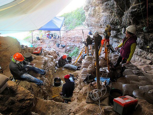
My next stop was in South Africa, at a series of cave shelters at Pinnacle Point on the southern coast. The first cave to be excavated, PP13B, has given us the earliest evidence for human consumption of shellfish – dated to around 164 000 years ago. Cave PP13B also contained evidence for early use of ochre pigment and heat treatment of stone artifacts. PP5-6 has provided the earliest known evidence for the knapping of microliths to make composite tools (possibly the earliest evidence for projectile points around 71 000 years ago), and to make those microliths they focused on heat treatment to improve the stone. Today a large interdisciplinary team is working together at the rockshelter PP5-6 to provide a fuller context within which to understand how early humans were living in this area many tens of thousands of years ago. The archaeological material being excavated at Pinnacle Point is providing information about the evolution of modern humans and therefore its importance goes beyond that of a single country or cultural group – this is how our shared human story began. The types of innovations that have been revealed by the excavations in the cave shelter complex share some major traits: cooperation, organization and planning. For example, the archaeological evidence of shellfish collecting implies a knowledge/awareness of lunar cycle as this activity can only be done at low spring tide (a new and full moon). Once this knowledge began to be implemented to harvest shellfish the people living at Pinnacle Point had a predictable source of calorie rich protein with which to supplement their diet.
PP5-6 contains archaeological material that dates from between 90 – 50 000 years ago. There is one long section through the entire cave shelter that connects all the stratigraphic layers from the earliest to the latest. The stratigraphy at the base of the ‘long section’ is so deep that it has been completely buttressed with sandbags. I had never excavated such ancient archaeology before and I was keenly aware of this. At Pinnacle Point the level of detail being recorded was truly astounding. A really exciting innovative technique developed by the Pinnacle Point team is the use of barcode scanners to record all artifacts, samples, sieved buckets and archaeological features (lot numbers, stratigraphic units, contexts, etc.). The barcode scanners are directly connected to a handheld computer that is connected to a total station (a high tech piece of survey equipment that makes digital 3D maps). Each time an artifact is found its coordinate in 3D space is plotted with the total station and this information is stored in that total station’s tablet. A barcode is then scanned and placed in a bag with the artifact. Each artifact gets its own individual barcode. Since the archaeological feature that artifact came from also has a barcode (previously scanned into the system) when the artifacts are analyzed and catalogued back at the lab the barcode is simply scanned again to access all data associated with that artifact and the location it came from in the excavation. There are two recorders on site and each is responsible for all the forms and logs for half the excavation. The excavators and recorders work together to ensure that all information logged is correct: the sediment excavated (its color, texture, moisture level and composition), the artifacts uncovered (types, amount, orientation and distribution), samples collected, photographs taken, and much more. Tablets are great pieces of tech for doing this type of work! They are lightweight and mobile so can easily be carried around an archaeological site from excavator to excavator. A really nice feature is the ability to take a photo with the tablet, draw on the photo and make notes related to what was excavated and what still needs to be excavated, then upload it directly onto the stratigraphic unit form on the tablet. It is amazing to see the activity on site with excavators furiously digging, the site recorders moving between their workstation and the excavators, and 5 total stations being run simultaneously to keep up with the amount of archaeology being revealed.
In the end, the excavations at Pinnacle Point are teaching us about the complex lives of our earliest human ancestors. It is possible that the individuals that created the archaeological remains being unearthed are the ancestors of those humans who went on to populate the globe.
For More See: https://popular-archaeology.com/issue/summer-2017/article/discovering-our-ingenious-early-human-ancestors
Image: The team working at the lower end of the excavation in PP 5-6. Courtesy Kate Leonard
Greece
In Greece, I worked with the Stélida Naxos Archaeological Project (SNAP), an international team led by Dr. Tristan Carter of McMaster University through the Canadian Institute in Greece, along with his co-director Dr. Demetris Athanasoulis of the Cycladic Ephorate of Antiquities of the Hellenic Republic’s Ministry of Culture and Sports. This team is investigating the hilly peninsula of Stélida on the island’s western coast, home to the earliest known archaeological site in the region. The hill itself is basically one big chert source where people came to get raw material for making stone tools since the Lower Palaeolithic (at least 250,000 years ago) and through to the Mesolithic (to 9,000 years ago). What is being found in the excavations are the leftovers from thousands of years of removing chert from the outcrops and the roughing out of stone tools. This isn’t necessarily where hominins and, later on, humans lived — instead, the archaeological material being uncovered indicates that Stélida was a place returned to again and again to extract chert from which to make sharp and durable tools. At Stélida there is known Middle Palaeolithic activity identified from diagnostic prepared core technology, demonstrating that some of the anthropogenic material found here can be securely dated to the time when Neanderthals were living in Europe. It is also possible that there were other hominid species taking away and using Stélida chert even earlier, suggested by the tantalizing evidence for Lower Palaeolithic activity in the form of possible bifaces that could be interpreted as handaxes; these large heavy tools could have been made by Homo heidelbergensis, the predecessor of the Neanderthals in Europe. The possibility for evidence of these early hominids living on what are now the Cycladic islands has not been seriously investigated before and if conclusively verified will change how we understand the movements of hominids across the globe.
A very early site that was primarily used as a raw material source doesn’t necessarily contain all the lovely (easily identified) stone tools that would be found on a habitation site — instead, you find the leftovers from making these stone tools. There is so much lithic material being found at Stélida that the team struggles to wash it so the lithic specialist can assess it and inform the team of diagnostic pieces uncovered. I was tasked with excavating a 2m x 2m trench about ¾ of the way up the hill that was positioned immediately at the base of a substantial chert outcrop. Until I had excavated about a meter below the modern ground surface half of the soil was full of stone tool making leftovers (debitage) and identifying the lithic material was initially a challenge for me.
Not only is Stélida a stunningly beautiful location to dig, but there is the possibility that my contribution to the project will help us better understand how hominids and humans spread across the globe. It was exciting to be part of a project that is asking difficult questions and trying to reassess how we are interpreting the archaeological record. The debris left behind as raw material was selected and worked from the same locations over thousands and thousands of years. This can inform archaeologists about the different behaviors and skills of these hominids. This exciting groundbreaking research is investigating a previously overlooked region of Greece for possible alternative routeways for Homo sapiens and their ancient predecessors’ movements from Africa into Europe and Asia.
For More See: https://popular-archaeology.com/issue/summer-2017/article/the-ancient-workshop-of-naxos
Image: A view of the trench where Kate was excavating. Courtesy Kate Leonard
Ireland
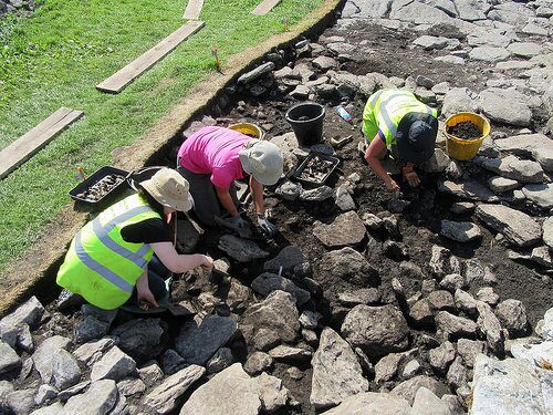
The next stop was Ireland, with the Caherconnell Archaeology Field School (CAFS), directed by Dr. Michelle Comber. Caherconnell Cashel is a possible indigenous royal settlement occupied from the 10th century to the 15th/16th centuries AD. The ‘cashel’ is a drystone (no mortar) enclosure: a 4m-high limestone wall enclosing a circular area that contained dwellings, the enclosure having an east-facing entrance. Already the excavations in the interior of the cashel have revealed evidence for a series of occupation/building phases that indicate a long period of use. Many medieval artifacts have been uncovered, such as clothes-fastening pins (aka dress pins) of various styles, glass and amber beads, iron knives and shears, and intricately carved bone hair combs. Stone walls, animal bone and finely worked metal objects all come together to tell the story of the medieval ‘native’ Irish Gaelic people who lived and worked at Caherconnell –- a story not fully told through written history. The seasonal digs at Caherconnell are helping archaeologists and historians to better understand the lifestyle of Gaelic Irish people in the medieval period, a period whose narrative is often dominated by the archaeology, architecture and politics of the invading Anglo-Normans (from the 12th century AD). It is very important that the story of the native population be put back into the narrative of medieval Ireland. Understanding the daily lives of Caherconnell’s medieval occupants can help to fill-out this narrative and the underlying limestone bedrock of the region creates an alkaline condition (non-acidic) that preserves bone wonderfully, thus allowing for a fuller understanding of the average diet. The large animal bone assemblage from the site indicates that the cashel’s occupants throughout the medieval period had a rich varied diet including pig, sheep/goat and cow milk products and meat, fish, shellfish, and poultry which also means eggs. The meat in their diet was supplemented with gathered herbs, fruits and nuts (like the ever present hazelnut!), and cereal grains like barley, oats, rye and wheat ground by hand into flour and/or meal using heavy stone rotary querns.
Since I worked with Dr. Comber on a nearby project (for three seasons) in the past I was asked to help supervise the students on-site. Most of the students had never excavated before and it is great fun to dig beside them and experience the joys and disappointments of being a rookie ‘digger’ as they did. The bedrock is very close to the topsoil (in some cases only 10cm but in others can be up to a meter in depth) in the Burren and so a large area can be excavated down to the natural level in a short period of time. I was digging in an area of the site where the foundations of a round structure, and associated internal features, were revealed that likely date to the earliest occupation of the cashel – the 10th century AD. This structure appears to have been some sort of kitchen/workshop area.
The stone fort itself is open to the public through the Visitor Center (which has a wonderful cafe!). This working farm and tourist destination is run by Mr. John Davoren, the landowner, and is a shining example of an archaeological site integrated into a sustainable family business.
For More See: https://popular-archaeology.com/issue/summer-2017/article/digging-irish-history
Image: Field school team members excavating at the site of the Caherconnell Cashel. Courtesy Kate Leonard
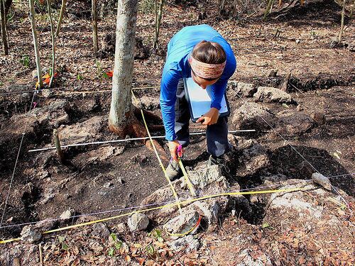
Portugal
In Portugal, I participated in an excavation led by site directors Miguel Serra and Eduardo Porfirio and supervisor Sofia Eiras. They investigated the Late Bronze Age (1250-850 BC) fortified hilltop settlement of Outeiro do Circo in the Alentejo plain of southern Portugal. The site covers about 17 hectares. This huge area was enclosed by a complex defensive system: a double wall of stone, fire hardened clay and wood was augmented with bastions, ramps, platforms and an exterior retaining wall built on a disused ditch. By its size alone it is clear that Outeiro do Circo was an important location in the region and this season the team was investigating the interior area. The team opened a number of trenches on the summit of the hilltop and just inside the enclosing wall. Their goal was to gain a better understanding of what went on inside the wall during the Late Bronze Age and to assess the level of disturbance to the archaeology from modern farming. Outeiro do Circo is one of the largest settlements of this time period in the Iberian Peninsula. It is also situated in an area which has (relatively recently) undergone significant archaeological investigation due to infrastructure development. Because of this development it is now known that the large fortified Outeiro do Circo settlement was not isolated in the Late Bronze Age but was in fact located in a landscape dotted with small contemporary settlements – a perspective which drastically changed archaeological understanding of this regions Bronze Age.
I was tasked with digging a trench on the northwestern slope of the hill within the line of the wall. Within the trench some exciting evidence of Bronze Age activity was found – including a cup-marked stone and various types of diagnostic pottery. One morning when I arrived on site the sunrise was slanting across the site and I noticed some indentations on one of the larger stones in the trench. As I excavated this stone it became clear that it was decorated with prehistoric cup-marks, intentionally created by one or more people and then positioned in the Late Bronze Age structural feature we were revealing. Cup-marked stones, or in Portuguese “rochas com covinhas” – or just “covinhas” for short -are a type of prehistoric decorated stone found across western Europe. They are difficult to date but are certainly prehistoric – Neolithic, Copper Age and/or Early Bronze Age – and have frequently been found reused on later prehistoric sites, as is the case at Outeiro do Circo. The cup-marked stone from my trench is the fourth found at Outeiro do Circo. One was found at the base of a deep Late Bronze Age pit close to the summit of the hilltop and another was used in the construction of the top course of the enclosing wall. The fourth is a large boulder that sits in situ where it was decorated. This has by far the most cup-marks on it and is located in a part of the hill that would have been ideal for settlement. This stone must have been known about in the Late Bronze Age when the hill was being fortified. The cup-marked stones found at Outeiro do Circo were not reused in a context that could be interpreted as particularly special or religious, but still….the three smaller stones were integrated into the construction of features on the hilltop. It is particularly intriguing to me that here there are both smaller cup-marked stones that were moved from their original position to be reused and the large boulder that still sits where it was decorated.
Fragments of pottery from the Chalcolithic to the Roman period have been found on the ground surface at Outeiro do Circo but by far the most common are those from the Late Bronze Age. The archaeological investigations being conducted by the team here are helping to paint a vivid picture of it as an important Late Bronze Age settlement in what seems to have been a thriving region.
The Projecto Outeiro do Circo is highly engaged with the local community. They frequently post their findings on the project blog (http://outeirodocirco.blogspot.pt) and have regular evening talks about the project or topics related to it. The project also organizes site visits and workshops for children’s groups (and adults) over the summer. An even bigger initiative is the “12 Lugares, 12 Meses, 12 Histórias”, which involves the eleven regions around the central town of Beja showcasing their Bronze Age sites through walks and talks. This initiative was organized after I contacted the site director, Miguel Serra, about volunteering with them for month 8 of my 12 countries – 12 projects – 12 months Global Archaeology year.
For More See: https://popular-archaeology.com/issue/summer-2017/article/archaeologists-excavate-a-late-bronze-age-settlement-in-portugal
Image: The cup-marked stone emerging from the trench. Photo courtesy Kate Leonard
Scotland
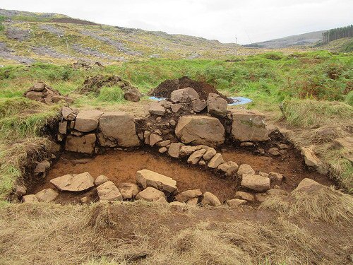
In Scotland, the Heritage and Archaeological Research Practice (HARP) has been collaborating with the Mull Archaeology Interest Group (MAIG) to investigate the small abandoned historic settlement of Kildavie in the North West Mull Community Woodland of Langamull on the Isle of Mull in the Inner Hedrides off the west coast of Scotland. The HARP team run a seasonal field school that excavates the remains of the Kildavie settlement which was occupied in the 17th and 18th centuries before its full abandonment. Sixteen buildings have already been identified on the site – mainly domestic dwellings, though the site may include locations of cottage industry. The reason for its final abandonment is unknown, as is the origin of the settlement. As part of Scotland’s Rural Past project Kildavie was surveyed by the Mull Archaeological Interest Group (MAIG), who mapped the general layout of the settlement’s buildings and enclosures which showed that the (approximately sixteen) buildings conform to a general shape and style of construction. Further analysis of the settlement over the past few excavation seasons has highlighted variety between structures that casts uncertainty on how each was used. While there is a grand narrative about the Highland Clearances in this part of the country – with some very real and harrowing accounts to go along with it – the story is not straightforward in every case. While some people were quickly forced out of their homes, other places were more gradually abandoned and Kildavie may be one of these.
HARP targeted three areas of the abandoned village for excavation during the season in which I participated: each focused on a different style of structure. Above all else the archaeological team is hoping that the excavations at Kildavie and the objects uncovered will provide more information about the lives of those who lived there. In the historic records there is no complete description of the number of people living in the settlement and what their occupations were. By excavating as wide a variety of structures as possible the team hopes to identify differences in dates of occupation and use of the structures. The team is also investigating the possibility that one or two of the structures were built for something other than a domestic dwelling, for instance for a cottage industry. It also seems that some buildings were ‘renovated’ and re-used for another purpose. This type of later reuse can be seen in the small dividing walls built in some of the structures, possibly after they went out of use as a home.
Historic archaeologists can often use written records and maps to identify sites and discover details about people who lived in the past. But equally there are aspects of past lives that were not recorded and can’t be learned from ledgers and letters. The investigations being conducted by HARP at Kildavie are a perfect example of how physical remains uncovered through archaeology can expand our understanding of historic records.
For More See: https://popular-archaeology.com/issue/summer-2017/article/uncovering-mysteries-on-the-isle-of-mull
Image: Revealing unwritten history through archaeology: Investigation of the structures and the associated artifacts will help shed light on the functions of the structures and the lives of the people who once occupied them. Photo courtesy Kate Leonard
Hawai`i
My next stop was Honolulu on the Hawaiian island of Oʻahu with the Archaeology Collections in the Anthropology Department of the Bernice Pauahi Bishop Museum, which is also the Hawaiʻi State Museum of Natural and Cultural History. The primary purpose of the Bernice Pauahi Bishop Museum is to serve and represent the interests of Native Hawaiians. In addition to the main exhibition areas that feature Hawaiian and Pacific natural and cultural history, the museum has an active program of rotating exhibits. The Bishop Museum staff is working to use their existing collections to develop dynamic programming for its visitors. Princess Bernice Pauahi Bishop was the last member of the royal Kamehameha Dynasty which ruled the (then) Kingdom of Hawaiʻi from 1810 – 1872. After she died in 1884, her husband, Charles Reed Bishop, founded the museum to honor her memory and to house the royal heirlooms she had inherited. The Bishop Museum was built on the grounds of the original Kamehameha Schools boys’ campus. An original school building, Bishop Hall, still stands on the museum grounds and one day will hopefully be restored to its former glory. In 1898, Charles Bishop had Hawaiian Hall and Polynesian Hall constructed, now both on the National Register of Historic Places. Today the Bishop Museum also has modern extensions such as the planetarium and is considered the premier natural and cultural history institution in the Pacific.
One of my tasks at the Museum was to scan and crop archival photos from the Stokes Collection. Together with William Brigham, the first director of the Bishop Museum, John F. G. Stokes was part of the first major archaeological survey of Hawaiian heiau in 1906-1909. These photos of archaeological sites, people and places are a record of Hawai‘i long before the tourists and resorts arrived. Some of these collections will soon be available through a new online database, and through them we can see the Hawai‘i that Brigham and Stokes were exploring over 100 years ago. I also helped to catalogue donated thin section slides of 3,000-year old Lapita pottery from the western Pacific that was studied by William Dickinson, who was one of the foremost experts in this area. These are thin slices of pottery sherds cut with a diamond saw and ground flat until they are microns thin and can be mounted on a glass slide. The slides can be examined under a powerful microscope to identify the minerals contained in the pottery, which can tell archaeologists about the type of clay and inclusions used to form the pottery, which can then be used to track the movement of raw materials. Once completed, this catalogue will be accessible to interested researchers from all over the world.
Today the Anthropology Department at the Bishop Museum is focused on using their existing collections in new research projects. The team is passionate about using non-destructive techniques to continue to learn more about the cultural and natural history of Hawaiʻi and the Pacific Islands. I got to see the team in action, zapping stone adzes with their portable XRF (x-ray fluorescence) machine. This device determines the elemental composition of a stone, which can tell archaeologists where it is from in the world. The Anthropology Department is particularly involved in the Hoʻomaka Hou Research Initiative and the Hawaiian Archaeological Survey project. One outcome of the Hoʻomaka Hou Research Initiative is the publicly accessible Online Fishhook Database, featuring over 4000 fishhooks from three sites excavated on Hawaiʻi Island in the 1950s by a joint Bishop Museum and University of Hawaiʻi team.
The creation of online databases so both researchers and the public can access and explore collections remotely is an important component of the work currently being done by the Bishop Museum, and the projects I worked on directly contribute to this on-going effort. There is a continuously rotating squad of volunteers who work diligently to process and digitize the Archaeology Collections of the Anthropology Department. Already this work had produced results: the Ho‘omaka Hou Research Initiative Online Fishhook Database, the Hawaiian Archaeological Survey (HAS) Database, and the Rapa Nui Interactive Radiocarbon Database can all be accessed online through the Bishop Museum website. The Hawaiian Archaeological Survey (HAS) Database is a searchable catalogue of over 12800 Hawaiian archaeological sites investigated by Bishop Museum archaeologists – a valuable resource for anyone interested in learning more about Hawaiian archaeology.
For More See: https://popular-archaeology.com/issue/summer-2017/article/a-national-treasure-tells-the-story-of-hawaiis-heritage
Image: Today the Bishop Museum is considered the premier natural and cultural history institution in the Pacific. Courtesy Kate Leonard
Canada
The almost thirty galleries of the Royal Ontario Museum (ROM) in Toronto, Ontario, Canada, display everything from T-Rex skeletons to Roman coins to Samurai armour – it is a museum that brings the world to the city of Toronto while showcasing Toronto’s architectural history to the world. Many of the ROM’s objects and materials were collected at the end of the heyday of collecting in the 1920’s. At this time Canada was much more integrated into the British Empire (with some of the provinces not even part of Canada yet) and so many collections were donated to the ROM from British officials who had travelled abroad. The correspondence of the ROM’s first curator of archaeology, Charles Trick Currelly, is very interesting to read as these letters reveal the vast global network of agents when museums everywhere used to acquire new and interesting objects. It often wasn’t possible for museum staff to travel to far flung places and so agents were used to identify and obtain new pieces for museum collections. The ROM came into being one hundred and fourteen years ago, on April 16, 1912, when the ROM Act was signed in the province of Ontario Legislature. This piece of law outlined the parameters of the museum and gave equal power over funding and development to the province and to the University of Toronto. About two years later the Royal Ontario Museums of Archaeology, Palaeontology, Mineralogy, Zoology and Geology were opened to the public. The original five galleries each housed a different museum: it wasn’t until 1955 that the five museums were amalgamated into one. In 1933 a new eastern wing facing Toronto’s Queen’s Park was opened to the public in the midst of the Great Depression. This wing and the original 1914 museum are today listed as heritage buildings of Toronto. The ROM continues to exhibit material from the five original museum themes of Archaeology, Palaeontology, Mineralogy, Zoology and Geology but these are now under the umbrellas of Natural History, World Cultures and Hands-on Galleries, as well as Temporary and Ongoing special exhibitions.
When I arrived the Royal Ontario Museum’s Anthropology Department was in the midst of a big collection storage move. One of my tasks was to open boxes of excavated material that had been accessioned but not yet re-housed. It is important to remove objects from boxes and/or bags that are ripped or deteriorating to make sure that the archaeological material is protected and not separated from any important information written on its storage container. It is fascinating to see the types of bags and boxes that archaeologists sometimes used in the past. They took advantage of whatever they had on hand in the field: newspapers, matchboxes, cigarette boxes and even bankers bags! Today museum professionals use acid free boxes and plastic bags to keep the collections safe from pests and harmful environmental factors.
Working with the staff at the Royal Ontario Museum was a special treat for me because, as a Canadian from the province of Ontario, the ROM was one of the first museums I ever visited. I have childhood memories of being transfixed by the Egyptian mummies and Classical Greek vases on display. Visiting as an adult, the architecture of the museum is as fascinating to me as the archaeological and natural history objects it exhibits. The totem poles that stand in the eastern wing of the ROM have always been particularly intriguing to me and I was thrilled to learn that the staircases there they stand were actually constructed around them when the wing was built in 1933.
Switzerland
On my final stop, I worked at the Institut für Archäologie, Universität Zürich, Switzerland. The main focus of the Universität Zürich archaeology department is to train the next generation of archaeologists through class and lab work as well as archaeological excavations in Switzerland and abroad. Every archaeology student at the Universität Zürich must complete an archaeological field school as well as a ‘praktikum’ with a heritage service or museum, in addition to their regular coursework. By making a field school compulsory the department ensures that each student who completes their studies has an understanding of excavation procedures. Fieldwork isn’t for everyone and archaeology is the type of profession that needs many people working off-site to make the entire process run smoothly. However, it is very important that those archaeologists who don’t do fieldwork have a first-hand awareness of where the data, artifacts, and/or materials they are investigating come from.
In order to facilitate the exchange of ideas and information more and more university departments are encouraging their staff and students to publish research in English. This allows for more international readership of their work. My task at the Institut für Archäologie of Universität Zürich was to edit an English language version of a multi-authored publication. Although there are many people at the university who can edit English documents, I was able to bring an archaeological perspective to the language and vocabulary needed to comprehensively communicate what the author intended.
Each institutional sphere – academia, museum, government – of archaeology in Switzerland fit together like one of the country’s famous watches. Each has a role to play in the wider organization of excavation, recording, processing, and maintenance and must rely on the other components to bring projects to completion. There was fantastically preserved cultural heritage all around me as I walked to and from the Universität Zürich each day and I enjoyed learning more about the long history of this beautiful city.
Connecting with Global Archaeology
I have been very lucky that each project I participated in was very different in terms of the research questions. So not only did I get the chance to explore 12 new cultures and countries but I got first-hand experience with types of archaeology I never would have experienced if I hadn’t left my own research focuses. This journey was not all sunshine and trowels: there was a large dollop of extreme weather events (Cyclone Winston), vermin (rats, cockroaches, possums, mosquitoes, etc.), in addition to the culinary delights (from kava to spiced offal).
Even though the countries and projects were different, there are basic things about archaeology that are the same all around the world in terms of methodology and interpretation. Essentially we dig and record what we find. The recording systems are fairly consistent across the world (context sheets, photos, spreadsheets, etc.) but the level of detail recorded, the technology available (total station vs. measuring tape) and the level of training available varies.
Since I was traveling with a purpose and a daily routine I was able to have experiences with local people and get insights into their lives and cultures that I have never had as a conventional tourist. Global Archaeology is about more than just digging holes, it is about making global connections — personal connections with the people I met and worked with, online connections with the people who followed my blog and posts, and connections between living people and people who lived in the past and shaped our world. Throughout the Global Archaeology journey I observed and participated in activities to inform communities about their local archaeology through outreach projects. Again and again I saw how effective archaeology can be as a mechanism for developing a sense of connection with the past. Holding an ancient object in your hand seems to bring the past very close to the present. Global Archaeology was, and still is, my vehicle for making and communicating these connections.
_________________________________________
_________________________________________
Receive 30 days free access to the popular new CuriosityStream lineup of documentaries on science, history, nature, and technology as a new Popular Archaeology premium subscriber.
___________________________________________
Travel and learn with Far Horizons.
____________________________________________
This richly illustrated issue includes the following stories: Recent findings shedding new light on the whereabouts of the remains of Philip of Macedon, father of Alexander the Great; how an archaeologist-sculptor is bringing bones of the dead back to life; archaeologists uncovering town life at the dawn of civilization; an exclusive interview with internationally acclaimed archaeologist James M. Adovasio about what makes the Meadowcroft Rockshelter prominent in the ongoing search for the first Americans; what archaeologists are finding at the site of the ancient city of Gath, the home town of the biblical Philistine giant, Goliath; and how scientists are redrawing the picture of human evolution in Europe. Find it on Amazon.com.