

Tel Burna is located in the heart of one of Israel’s most intensively researched regions, yet the site is one of a few multi-period settlements that has remained unexcavated until the current project commenced. Burna is located in the Judean Shephelah, along the northern banks of Wadi Guvrin (Figure 1). Sites in its immediate vicinity include Lachish, Maresha, Tel Goded, Tel Zayit, with Tell es-Safi/Gath and Azekah also in close proximity. This region represents a rift between the southern Coastal Plain in the west and the Highlands toward the East. A wide range of evidence, including Egyptian, Assyrian and Babylonian texts, biblical passages, and epigraphic and material cultural finds, attests to the importance of this region as a borderland in the Bronze (3300 – 1200 BCE) and particularly in the Iron Age (1200 – 500 BCE), when Judahites and Philistines settled on opposite sides of the border.
_______________________________________
 Figure 1: Location of Burna in relation to other archaeological sites in its vicinity.
_______________________________________
Several surveys have been conducted in the region, including Aharoni and Amiran’s survey of Shephelah mounds in the 1950s, Peterson’s examination of the ‘Levitical’ cities in the 1970s, Dagan’s survey of the Shephelah and Koh’s survey of the tell approximately ten years ago. However, the site had never been excavated until the summer of 2009, when we began a long-term archaeological project on the site.
The Project’s Goals
One of the primary research questions that the project aims to address is the role of borders in the southern Levant of the Bronze and Iron Ages. Therefore we have determined to examine the relationship of Tel Burna with its surroundings on both sides of the border. This will reflect the geographical border between highlands and lowlands, which affected the culture of these two regions in all periods. Several questions on this topic will be addressed, include the following: How did the border move in different periods? How were sites along the border affected by this movement? How did the material culture at sites on the border differ from those inland, due to the proximity to the other nearby entity? Finally, what can we learn from the border sites about Philistine-Judean relations in different periods?
The second research goal relates to economic systems. A cultural frontier is a contact zone between cultures, serving as a catalyst for socioeconomic processes. While Judah played a smaller role in the greater economic and geopolitical system of the Iron Age southern Levant, it is still possible to discern some activity and influence in Judah, particularly near its western border. Philistia however was more active in global economic and political trends. The excavations at Tel Burna will stress how the border was affected by different economic and political trends in the region. For example, how did Philistia’s involvement in the world markets from the Iron Age II (1000 – 800 BCE) onward affect Judahite sites along the border? How did the Assyrian Empire’s presence affect the border – did it open up the border or was Judah still involved in more of a localized economy? How did the economic border function during the Iron Age I (1200 – 1000 BCE)?
The third goal is to further develop survey methodology and tools, in order to improve their quality and reliability as an archaeological technique and help in influencing attitudes towards field work in this respect in the Southern Levant.
Is Tel Burna Biblical Libnah?
The identification of the site has been debated for more than a century. There are scholars who have claimed that Tel Burna is biblical Libnah, which was mentioned several times in the Bible. This identification was based mainly on geographical and historical arguments. For example, according to the biblical tradition it was a Canaanite town that was conquered by Joshua, and also a city that was chosen as one of the Levitical cities. In 2 Kgs. 8:22 the city of Libnah was involved in the rebellion against Jehoram the king of Judah (in 9th century BCE) and later, a woman from Libnah married King Josiah in the 7th century BCE. To date, there are other candidates for the location of ancient Libnah, including nearby Tel Zayit. However, the exposed archaeological remains at Tel Burna support this identification, with both the geographical, survey and excavation data fitting well with what we know and expect from a border town in the Iron Age. Regardless of the identification of the site, it is clear that Tel Burna lies along the border between Judah and the Philistines, and was a prominent site during the Iron Age, making it a prime target for studying ancient borders.
The Survey
As mentioned above, one of our main goals was to develop a survey methodology to use in a multi-period site. The first step of the project was taken in 2009 with a surface survey. We have continued to reach this goal through test-pit excavations and the documentation of features visible on the surface, such as agricultural installations, caves and other man-made features. The results of these two methods have already been published in a scientific manner (Uziel and Shai 2011; Shai and Uziel 2014). Below is a concise presentation of the main conclusions of both methods.
The Surface Survey
The distribution of the sherds and other artifacts lead us to estimate that the settlement on the site covered 10 hectares. The significant periods of settlement were in the Early Bronze Age III (2700 – 2200 BCE), Middle Bronze Age IIB (1850 – 1750 BCE), Late Bronze Age II (1400 – 1200 BCE), and Iron Age I and II (1200 – 800 BCE) (Figure 2). One should note that only 9% of the identified sherds collected in the survey post-date the Iron Age. This indicates that the site was poorly settled during those periods.
_______________________________________
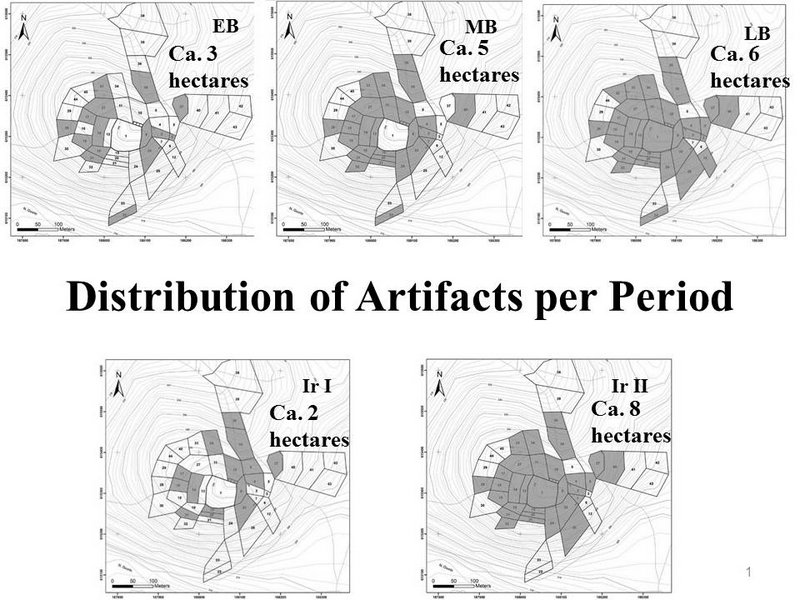 Figure 2
________________________________________
The Test Pit Survey
The circular test pits, with a diameter of 1m, were distributed according to the survey fields and excavated to a depth of 30 cm. The contents of all of the test pits were fully sifted, in order to remove any bias based on preference of pottery types. As the test pits only covered the upper tell and surrounding slopes and not the entire area covered by the surface survey, it is still too early to determine the site size according to the dispersal of artifacts in the test pits. However, a few points can be made regarding the area covered. First, the early periods (EBIII, MBII) detected in the survey do not appear whatsoever in the test pits other than stray sherds. Even in fields that yielded many EBIII/MBII sherds on the surface, such pottery was not found in the test pits. Second, the two dominant periods represented are the Late Bronze Age and Iron Age II, similar to the surface survey. This indicates the intensive settlement on the site during the LB and Iron Age II as also noted in the surface survey. Finally, as opposed to the surface survey, where Byzantine sherds were scattered in small amounts in different areas of the tell, the test pits yielded Byzantine pottery almost exclusively from the eastern slopes, where the lines of walls of a large building can be seen on the surface. It seems that there is a slightly closer affinity between the test pit results and the excavations as they remove the later periods, which are not actually represented on the summit. Earlier periods which are likely buried beneath the Iron Age remains, were not present in the test pits, yet were present on the surface.
The Excavations
To date, three areas have been excavated (Figure 3). Area A2 is located on the center of the summit of the tell, where a fortification system has created a flat, almost square area of 70 by 70 meters. The second area (A1) was placed along the eastern slopes of the summit, in order to create a section along the upper tell. The third is Area B, which was placed in the terrace just below the summit, to the west of the fortifications. Thus far, the two main periods that were exposed are the Late Bronze Age (in Area B) and the Iron Age II (in Areas A1 and A2).
_______________________________________
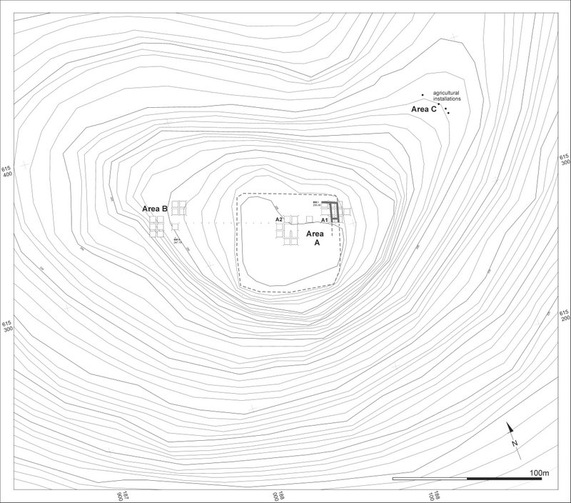 Figure 3: The excavated areas
_______________________________________
The Late Bronze Age Remains
A portion of a large 13th century BCE public building was uncovered only a few centimeters below the surface in Area B. Although the plan of the building is still unclear, the size of the building and the construction technique clearly indicates that it was not a common domestic building. The bedrock in the large courtyard (16×16 m) is very high and was used as a surface in several places, while in other parts of the area, there are signs of intentionally filling in of gaps in the bedrock. Three Cypriot votive vessels were placed on a flattened stone, which was located where the bedrock had a natural hump (Figure 4). The finds include a scarab with dozens of beads, a cylinder seal, a rich ceramic assemblage and many animal bones. Some of the pottery vessels may reflect the activity that took place in this courtyard. These are comprised of (Figure 5) goblets and chalices, which are often associated with feasting activity, Cypriot zoomorphic vessels (for liquid libation?), local and imported (Cypriot and Mycenaean) figurines and two fragments of different ceramic masks. One can also note two large (ca. 200 liters volume!) imported Cypriot pithoi. All in all, the building size and the effort that was undertaken in order to build it alongside the presence of unique vessels indicate that this was a 13th century public building where ritual activity took place within its courtyard. Since we have not yet finished the excavation of the building or the analysis of the finds, it is too early to determine the exact purpose of the building.
_______________________________________
 Figure 4: Aerial view of Area B
_______________________________________
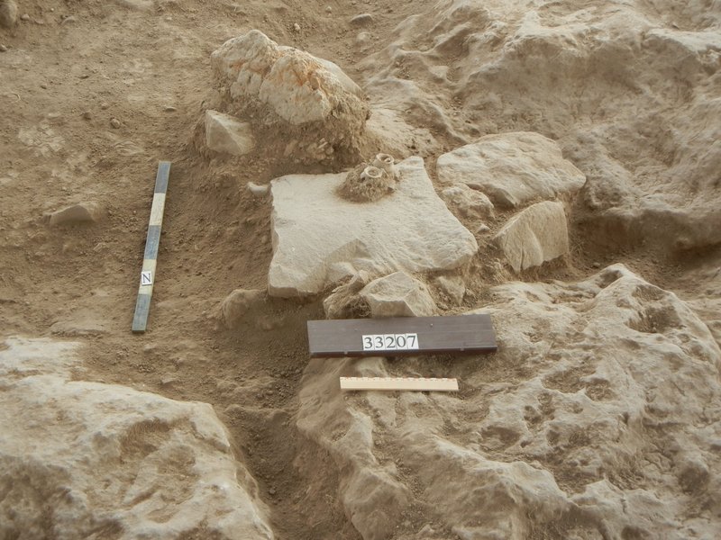 Figure 5: Cypriot votive vessels in situ
______________________________________
The Iron Age Remains
While there is evidence of Iron Age I settlement at the site from the survey, we have yet to reach these levels in the excavations. However, the two areas on the summit and its eastern slope reveal a series of strata from the ninth century BCE to the Persian period.
The summit is defined by the distinct remains of fortification walls. The excavations thus far have revealed a segment of the fortification walls in the NE corner of the summit that was partially exposed along the perimeter of the upper tell. The fortifications of Tel Burna were in use during the ninth and eighth centuries BCE. The Iron Age II wall reflects the role of this site during this period. The location of Tel Burna—midway between Gath, the dominant Philistine city in the Iron Age IIA, and Lachish, the main Judahite city, monitoring the road along Nahal Guvrin, with visibility all the way to the coastal plain — would account for the investment of the central authority of Judah in establishing such a walled city so close to the city of Lachish.
In the center of the summit (Area A2) a portion of a typical four-room house was uncovered, which was destroyed at the end of the eighth century BCE, as indicated by the smashed vessels found on its floors (Fig. 6). It is tempting to correlate this destruction with Sennacherib’s campaign (701 BCE), although it is too early to determine if this is a local destruction or something more elaborate.
___________________________________________
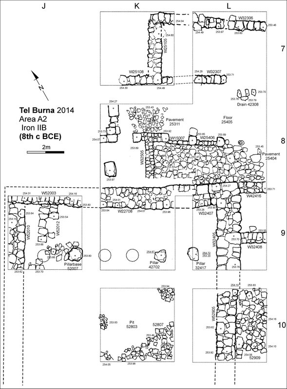 Figure 6: Excavated portion of a typical four-room house structure
________________________________________
Among the pottery finds there are stamped jar handles (Figure 7) several of the LMLK type and one with a private or official seal bearing the names לעזר/חגי (to Ezer son of Haggi).
This building was only partially exposed but a few points can already be highlighted:
1. Combining the fact that it was located inside the fortified area with the building size, technique and the discovery of a LMLK stamped handle suggests that this was a public or an elite building.
2. The pottery assemblage is typical of the end of 8th century BCE and is very similar to Lachish Level III.
3. Several pillar figurines were discovered in this building. As noted in the past (Kletter 1995), this figurine is typical to Judah.
4. To date, we have yet to uncover evidence for a widespread destruction as expected for eighth century BCE Shephelah sites, save for one portion of the four room house. Such a destruction is further expected if the site is in fact Libnah, which according to the biblical text was destroyed during the Assyrian military campaign.
______________________________________
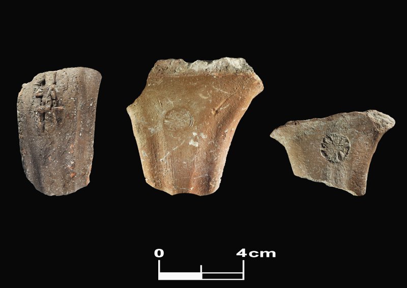 Figure 7: Stamped jar handles
______________________________________
The Iron Age IIC (7th century BCE) remains uncovered at Tel Burna consist of a series of silos and related architectural elements (Figure 8). Six such silos, all lined with stone, cut into the earlier remains, sometimes even reusing earlier features, and are spread over the entire summit.
The silos yielded archaeobotanical remains recovered through flotation of the sediments. Archaeobotanical analysis yielded 16 different crop taxa and 32 wild plant taxa, among them one can mention wheat, barley and figs. The presence of Rosette stamped handles indicates the site was affiliated and under control of Judah in this period as well. This point is crucial in light of the identification of the site with biblical Libnah, as according to the bible, Josiah’s wife (the king of Judah in the second half of the 7th century BCE) was from Libnah.
______________________________________
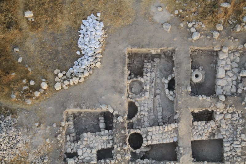 Figure 8: The casemate fortifications, partially cut by one of the 7th century BCE silos
_____________________________________
Conclusions and Future Plans
Tel Burna was settled from the 3rd millennium BCE throughout the mid-1st millennium BCE. The settlement at the site reached its pick in two periods – the Late Bronze Age and the Iron Age II. The excavations thus far have revealed a public building well dated to the 13th century BCE (Late Bronze Age) where ritual activity took place. The Iron Age remains attested to the importance of the settlement at the site and that it was a fortified Judahite border site facing the Philistines in the west.
In the next excavation seasons we are planning to expand the excavated area in order to complete our view of the LB public building, the Iron Age fortification system and the Iron Age administration. We also plan to excavate several agricultural installations, in collaboration with several scholars in various specialization fields (e.g. soil, geoarchaeology, archaeo-botany, aDNA etc.) in order to gain a better understanding on the economic life of the inhabitants of the site. In addition, an in-depth study accompanied by an excavation of Late Bronze Age burial caves will allow us to investigate more about the people who lived in Tel Burna and their customs, both in life and in afterlife.
_____________________________________


