Abstract: Although the Hensbacka, as a group of hunter-gathers, has been known along the coast of western Sweden since the early 1920’s, it is only within the last decade that the group has been considered from an anthropological, and therefore economic, point of view.
This is a short paper about a long process: cultural change in time and space induced by environmental parameters within a socio-economic framework. It is a regional model of what could have happened – and most likely did.
Introduction
It has been put forth in a previous publication that there can be as many as 10,000 early Mesolithic sites in the county of Bohuslän (fig.1) to the north of Gothenburg. (Schmitt et al. 2006). These sites can be dated to between ca.12,000 – 10,500 cal.BP (Schmitt & Svedhage 2015c) and are referred to as the Hensbacka culture group, an early phase of the Hensbacka/Fosna tradition. Since the latter contains artifacts that are inherent to the Ahrensburgian technocomplex on the North European Plain, such as unifacial opposed platform cores and tanged points (fig. 2b) it has been generally accepted that the Ahrensburgian, Hensbacka and Fosna culture groups are interrelated (Schmitt 1999, 2006; Fuglestvedt 2007). Our use of the term ‘site’ should be taken to mean activity area defined by a limited deposition of chipped flint that displays diagnostically relevant attributes.
The purpose of this short article is to explicate one of the reasons why this interrelationship existed.
Even more sites than originally estimated?
Recent field investigations in central Bohuslän (fig. 2a) have resulted in both additional Hensbacka sites and typical artifacts in the form of tanged points and classical opposed platform cores (fig. 2b). As a generalization, it is reasonable to state that after severe storms in Bohuslän, that fall many trees, it is obvious that there seems to be a Hensbacka site under almost every pine tree. Consequently, the more storms we have – the more early Mesolithic sites we find. Curiously, this agrees well with our estimated vast number of sites mentioned earlier.
Environmental circumstances that made a difference.
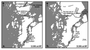
During the close of the Late Glacial and the beginning of the Post Glacial, the topographic, oceanographic, and hydrological conditions in the North Sea Basin and along the coast of western Sweden were very different. The combined effect of these environmental circumstances was unique in Northern Europe. In conjunction with easterly moving currents, nutrient salts removed from land being inundated in the North Sea Basin were transported to the coast of western Sweden (Schmitt 1994, p.253-254). In addition to this feature, isostatic rebound in the Vänern Basin constricted out flowing melt water (see Schmitt et al. 2006, p.7, fig. 6) whereby flow rates within the reaction current increased. Indeed, the velocity of tidal currents in the archipelago must have been significant in that numeric tidal models indicate a tidal amplitude, or M2 of about 60 cm along the coast of Bohuslän; this means that the difference between high and low tide was about 1.20 meters (ibid. p.15, fig.12a). In consequence, mixing due to turbulence within the water column caused by islands in the archipelago was enhanced. Turbulence on the lee side (in relation to a current) of islands served as a nutrient injection in the outer archipelago and is referred to as “island wakes” — a primary cause of increased phytoplankton production in that particular area (Hasegawa 2009, p.1-4; Schmitt 2015b, p.110). Consequently the biomass and therefore the carrying capacity of the sea along the coast of Bohuslän, was significantly enhanced by nutrient rich currents from the west and phytoplankton production through upwelling induced by island wakes on the leeward side of islands in the outer archipelago. In short, increased isostatic rebound in the Vänern Basin – in conjunction with increasing rates of inundation in the North Sea Basin, provided unparalleled circumstances for seasonal resource exploitation by visiting groups of hunter-gatherers from the Continent. This environmental/ecological situation continued until about 10500 cal BP, at which time the Otteid and Uddevalla straits dried up (Fredén 1988, p.70) (fig. 3b).
In conjunction with these “island wakes” and the upwelling in the outer archipelago, it has recently been pointed out that iron enriched glacial melt water has a positive effect on the growth rate and blooming of phytoplankton (Gerringa et al. 2012, p. 25). It is noteworthy that fluxes of iron, derived from biogeochemical weathering processes, have also been documented in glacial melt water along the coast of eastern Greenland, where it promotes phytoplankton growth and blooming in the sea (Statham et al. 2008, pp. 1-11). Indeed, the bioavailability of iron in glacial melt water and eventual input of this iron into the sea, is a current research area that is receiving considerable attention (see Raiswell 2011, pp.1 & 105; Wadham 2010, p.7). Accordingly, if we had the same biogeochemical weathering processes at work in the Vänern basin during deglaciation – the iron enriched melt water flowing into the archipelago of Bohuslän would have been an excellent complement to upwelling nutrients and phytoplankton growth in island wakes. The relatively high latitude of Bohuslän (58” 20´ N for the town of Uddevalla) should also be taken into account in that both favorable light conditions and sufficient iron concentrations are required for optimum phytoplankton growth rates (Blain et al. 2001, p.182). Clearly, we need not question light conditions along the Swedish west coast during the summer. Furthermore, sedimentological studies concerning the glaciomarine deposition of clay in the vicinity of Gothenburg indicate that glacial melt water, flowing into the archipelago, had significant iron content (Stevens et al. 1987, p.245 & 250). Accordingly, we had both favorable light conditions and elevated iron concentrations that would have enhanced already high growth rates of phytoplankton in the outer archipelago due to island mass effect.
The distinct increase in the benthic foraminifera population in the archipelago of Gothenburg at about 11700 cal BP (Bergsten 1989, plate 2) (see also Björck 1995, p.31) strongly suggests a significant iron input from outflowing fresh water during the Baltic Ice Lake drainage in the late Younger Dryas. In brief, benthic foraminifera feed on phytoplankton when they sink to the bottom (De Nooijer et al.2008, p.719 – 721; Schönfeld et al. 2007, p.89; Diz et al. 2006, p.11); consequently, a large benthic foraminifera population is supported by a large, and expanding, surface phytoplankton population (Gustafsson et al. 1999, p. 176-177). As can be seen in the data provided by Bergsten (1989) in plate 2, this is a situation that existed between ca. 11700 – 11500 cal BP and can be correlated, in archaeological terms, to the Hensbacka culture group.
It should also be mentioned that new data concerning the Kattegatt and archipelago of Bohuslän during the close of the Late Glacial has recently been extrapolated from an international tidal modeling program (Uehara et al. 2006). These new data indicate that a tidal mixing front existed at the northern end of the Kattegatt between the coast of eastern Denmark and the coast of western Sweden (Schmitt 2015:b, fig.4a) and that the M2 (tidal amplitude) in the southern end of the Kattegatt was about 1.4 meter (Uehara, pers.comm. Nov. 2011). Tidal mixing fronts, like the island wakes already mentioned, are areas of high biological production – primarily in the form of extensive phytoplankton populations. It can therefore be inferred that a significant amount of this population was transported to the archipelago of Bohuslän by northward moving currents (see Schmitt et al. 2006, fig. 4, p.5).
If we take into account the above mentioned environmental/ecological conditions, the archipelago in Bohuslän was something of a veritable paradise for hunter-gatherers on a seasonal round. The exceptionally productive marine food web seems to have sustained a high level of human use as witnessed by the numerous Hensbacka sites (Schmitt et al. 2006, p. 20). Capelin (Mallotus villosus) are known to spawn on gravely beaches where they can be collected by hand and are often followed to the shore by Atlantic cod (Gadus morhua) from deeper water. Herring (Clupea harengus), in this regard, are also of interest in that both capelin and herring are exploited as a major food source by harp seals (Pagophilia groenlandicus), ringed seals (Pusa hispida) and bearded seals (Erignathus barbatus). All of these species are known to have been present along the coast of Bohuslän during the Late Paleolithic /early Mesolithic transition (Schmitt et al. 2009, p.12) as well as Haddock (Melanogrammus aeglefinus), Whiting (Merlangius merlangus) and Ling (Molva molva) (Jonsson 1995, p. 159). Consequently, it is not surprising that we have up to 10,000 early Mesolithic sites in the county of Bohuslän on the Swedish west coast (Schmitt et al. 2006, p.20). The term ‘site’ should be taken to mean activity area.
In a more low-key perspective, it should be taken into account that the transition between Late Glacial and early Post Glacial conditions took place within about two generations (Björck et al. 1996, p.1166; Lowe et al. 2008, p.9, fig 1). This suggests two possibilities.. Firstly, reindeer might have altered their seasonal migration routes – or perhaps departed from the North Central European Plain completely. And secondly, early visitors to Bohuslän soon discovered that they could not be in two places at the same time. That is to say, when in Bohuslän, it was impossible to know when seasonally migrating reindeer will arrive in the Hamburg area in general. Indeed, sharing in the rewards most certainly required participation in the hunt.
Without a doubt this could have developed into a situation where decisions were needed regarding a changing lifestyle.
_______________________________
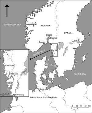
Fig.1 – Map showing geographical areas and archaeological sites mentioned in the text.
______________________________
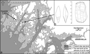
Fig. 2 – Map (a) showing the present and past shore line, at ca. 10500 cal BP, of central Bohuslän. The archaeological site referred to as Djupedal (T-325) represents a site from the late Hensbacka group, while the Sandbacken (Ua-157) site relates to the earliest phase of the Hensbacka (see Schmitt & Svedhage 2015). The tanged point and opposed platform core seen in (b) are not uncommon finds from higher levels in terrain of central Bohuslän and indicate technological and morphological similarities with the Continental Ahrensburgian on the North Central European Plain (Fig. 1).
_______________________________
Fig. 3 – Isostatic rebound in the archipelago of central Bohuslän not only provided for increased land area in the form of additional islands, it also closed the straits connecting Vänern Basin with the sea at ca. 10,500 cal. BP. Compare maps (a) and (b). Arrows in the straits indicate the direction of flow for glacial melt water on the surface while a bottom current of heavier seawater, moved in the opposite direction – in the same strait. The mixing of these two currents took place around islands in the archipelago i.e. “islands wakes”.
_______________________________
Marine resources in a social perspective
Clearly, we cannot know what “they”, thousands of years ago, actually thought about social space requirements within a productive catchment area. However, and in general, it is thought that individuals or groups of individuals evaluated their own socio-economic advantage when a move between camps was made (Riches 1982, p. 19). In brief, work input in relation to time spent (cost) during the actual hunt is taken into account. Accordingly, time (cost) will increase in proportion to the number of people hunting the same species of prey in the same general area. When time expenditures exceed a certain limit, due to prey depletion, hunters will move to a new catchment area (Winterhalder et al. 2010, p. 469). Hence, in a pioneer colonization situation, these eventual moves between regional, or inter-regional, catchment areas can be interpreted as a cost-effective process. In short, when cost exceeds expected returns, a move is made.
This suggests that as the numbers of fishermen and hunters increased in Bohuslän, it required more and more time to obtain the same return as had been realized the year before. The only remedy would have been to move to another location within the same catchment area. From our point of view this would have been a compounded problem in time until a northern limit had been reached. That is to say, an area to the north far removed from the out-flowing melt water from the Vänern Basin and eventual mixing in the outer archipelago (“island wakes”)(see Schmitt 2015b, p.110). At present, it can be suggested that this “point to the north” was reached at about 11200 cal BP and is represented by the Pauler 1 site (fig.1) just to the NW of Larvik (Schaller Åhrberg 2012, p.118; pers.comm. Glørstad, Feb. 2017) on the west side of the Oslo Fjord. In short, crossing over the fjord became possible after the receding ice front had moved further towards the North (Glørstad 2014) at this time. Additional support for this model is forthcoming if we take into account the recent excavation at Elgsrud (Eymundsson and Mjærum 2015) a former island in the Oslo fjord during deglaciation that is now situated on the east side of the same fjord due to isostatic rebound (fig.1). Without a doubt the lithic material from both sites – Pauler 1 and Elgsrud – are very similar to the classic Hensbacka material from Bohuslän.
However, it is safe to assume the same problem that had presented itself in “good catchment areas” in Bohuslän – soon prevailed in coastal Norway as well. That is to say, population pressure increased the “cost” of maintaining a given subsistence platform. In consequence, supplementary sources, in the form of reindeer hunting and other inland animals, were sought in the mountains (Breivik & Callanan 2016).
The reason for this mixed economy in western Norway was two-fold. In brief, it is most probable that the biological productivity in the sea along the relatively short coast of western Sweden to the north of Gothenburg, i.e. Bohuslän, (fig.1) was greater than the productivity along the extensive coast of western Norway during the close of the Late Glacial and the beginning of the early Post Glacial. This discrepancy provided for a differentiated carrying capacity in these two areas which in turn led to different solutions in subsistence management. Naturally one can always refer to many “think if” or “what about” scenarioios – but we can never find a second “isostatic rebounding Vänern Basin” during the close of the Late Glacial / early Post Glacial. This enormous glacial melt water basin in western Sweden was a unique geographic feature that is difficult, if not impossible, to find elsewhere in northern Europe during this period of time.
The evidence; not only archaeological sites
In addition to the thousands of actual Hensbacka sites in Bohuslän, it is very interesting to note that the estimated volume of the well known shell-banks to the east of Uddevalla is slight more than one million cubic meters (Fredén 1988, p. 21). This enormous accumulation of sea shells, perhaps largest in the world, is C-14 dated to between 13000 uncal. BP and 9700 uncal. BP (ibid. pp. 76 & 80). Chlamys islandica have been used for dating in both cases.
The interesting point here is that these shell-banks are located in the old drainage basin/valley of the Uddevalla strait and clearly verify that the marine ecology within this area i.e. the archipelago of Bohuslän has been remarkable for at least 3000 years. Today this same valley is occupied by a small stream, flowing through the city of Uddevalla, which still empties into the sea; but the past dynamics within the local ecology only survive in the huge shell-banks that might well be, in terms of size, second to none in a global perspective. The existence of these shell-banks provides additional support for much of what has been put forth in this paper concerning the coastal carrying capacity of Bohuslän 12000 years ago.
A geographical change that promoted migration and regional cultural change?
In closing this short article, it seems appropriate to reflect on the demise of the Hensbacka culture group as we think we know it today. Once the Otteid and Uddevalla straits closed at ca. 10500 cal.BP (Fredén 1988, p.70) (fig. 3b) due to isostatic rebound, melt water from the Vänern Basin no longer reached the archipelago and the open sea (see Schmitt et al. 2006, fig. 6 p.7 & fig. 16 p. 21). As we already hinted earlier, this would have been catastrophic for groups of maritime foragers. The time required – if possible at all with an extended population in a regional catchment area, to maintain the daily subsistence base would have increased to unrealistic proportions. The social effect was given; a slow decline in population growth and increased migrations. Indeed, this would have opened the door for new cultural impulses – such as the Sandarna with their microblade technology.
In retrospect, it is not an exaggeration when we suggest that the Hensbacka group represents a classic example of environmental adaptation at the close of the Late Paleolithic and the beginning of the early Mesolithic, that is to say between ca. 12000 – 10500 cal. BP. In a more holistic perspective, the Hensbacka and Fosna culture groups are one and the same and represent a transitional phase within the Ahrensburgian technocomplex during and after the close of the Younger Dryas climate event.
Conclusions
Our conclusions regarding the Hensbacka group in Bohuslän are straightforward and few in number. Firstly, continued field work, especially at higher levels in the terrain, reveal additional sites that have previously been unknown. Secondly, these continued investigations show no reason to doubt the earlier observations that a relationship does exist between the Hensbacka and Ahrensburgian technocomplex –as well as the Fosna in Norway. Last, but by all means not least; this interrelationship and/or transitional phase, was due to the enhanced carrying capacity in the sea along the coast of Bohuslän; the “prime mover” in this case was the Vänern Basin and straits leading west into the archipelago (fig. 3a).
References
Bergsten, H. 1989: Stratigraphy of a Late Weichselian-Holocene clay sequence at Göteborg, south-western Sweden. Thesis A 68, Chalmers Tekniska Högskola och Göteborgs Universitet, Geologiska Institutionen. Göteborg. 1-115.
Björck, S. 1995: A review of the history of the Baltic Sea, 13.0-8.0 ka BP. Quaternary International, Vol.27, 19-40.
Björck, S., Kromer, B., Johnsen, S., Bennike, O., Hammerlund, D., Lemdahl, G., Possnert, G., Rasmussen, T.L., Wohlfarth, B., Hammer, C.U., Spurk, M., 1996: Synchronized Terrestrial-Atmospheric Deglacial Records Around the North Atlantic. Science, Vol. 274, 1155 – 1160.
Blain, S., Tréguer, P., Belviso, S., Bucciarelli. E., Denis, M., Desabre, S., Fiala, M., Jézéquel, V.M., Le Fèvre, J., Mayzaud, P., Marty, J-C. and Razouls, S. 2001: A biogeochemical study of the island mass effect in the context of the iron hypothesis: Kerguelen Islands, Southern Ocean. Deep-Sea Research I 48, 163-87.
Breivik, H.M., Callanan, M., 2016. Hunting High and Low: Postglacial Colonization Strategies in Central Norway between 9500 and 8000 cal bc. European Journal of Archaeology 19, 571-595.
De Nooijer, L.J., Duijnstee, I.A.P., Bergman, M.J.N., Van der Zwaan, G.J. 2008: The ecology of benthic foraminifera across the Frisian Front, southern North Sea. Estuarine, Coastal and Shelf Science 78, 715-726.
Diz, P., Francés, G. and Rosón, G. 2006: Effects of contrasting upwelling – downwelling on benthic foraminiferal distribution in the Ria de Vigo (NW Spain). Journal of Marine Systems 60, 1-18.
Eymundsson, C.G. and Mjærum, A. 2015: I fotsporene til steinalderpionerene – En utgravning av pionerboplassene på Elgsrud I Sørmarka. Follominne 53, 15-30.
Fredén, C. 1988: Marine life and deglaciation chronology of the Vänern basin southwestern Sweden. Sveriges Geologiska Undersökning, Ca 71, Uppsala. 1-80.
Fuglestvedt, I., 2007. The Ahrensburgian Galta 3 site in SW Norway; dating technology and cultural affinity. Acta Archaeologica, 78 (2), 87-110.
Gerringa, L.J.A., Alderkamp, A-C., Laan, P., Thuróczy, C-E., De Baar, H.J.W., Mills, M., van Dijken, G.L., van Haren, H. and Arrigo, K. 2012: Iron from melting glaciers fuels the phytoplankton bloom in Amundsen Sea (Southern Ocean): Iron biogeochemistry. Deep-Sea Research II 71-76, 16-31.
Glørstad, H. 2014: Deglaciation, sea level changes and the Holocene colonisation of Norway. In Harff, J., Bailey, G. and Lüth, F. (eds.), Geology and Archaeology; Submerged Landscapes of the Continental Shelf. Special Publication of the Geological Society of London. 9-26.
Gustafsson, M. and Nordberg, K. 1999: Benthic Foraminifera and their response to hydrography, periodic hypoxic conditions and primary production in the Koljö fjord on the Swedish west coast. Journal of Sea Research 41, 163-178.
Hasegawa, D., Lewis, M.R. and Gangopadhyay, A. 2009: How islands cause phytoplankton to bloom in their wakes. Geophysical Research Letters, Vol. 36, L20605, doi:10.1029/2009GL039743, 2009. 1-4.
Jonsson, L. 1995: Vertebrate fauna during the Mesolithic on the Swedish west coast. In: A. Fischer (ed.): Man and sea in the Mesolithic: coastal settlement above and below present sea level. Proceedings of the international symposium held in Kalundborg, Denmark 1993. Oxbow, Oxford. .147-160.
Lowe, J.J., Rasmussen, S.O., Björck, S., Hoek, W.Z., Steffensen, J.P., Walker, M.J.C., Yu, Z.C., 2008: Synchronisation of palaeoenvironmental events in the North Atlantic region during the Last Termination: a revised protocol recommended by the INTIMATE group. Quaternary Science Reviews 27,. 6-17.
Raiswell, R. 2011: Iron Transport from the Continents to the Open Ocean: The Aging-Rejuvenation Cycle. Elements, Vol.7, 101-106.
Riches, D., 1982. Northern Nomadic Hunter-Gatherers: A Humanistic Approach. London, Academic Press. 1-242.
Schaller Åhrberg, E. 2012: Pauler 1 – En tidigmesolitisk boplats. In: L. Jaksland (ed.): E18 Brunlanesprosjektet, Bind II, Undersøkte Lokaliteter fra Tidligmesolitikum. Kulturhistorisk Museum, Fornminneseksjonen. Oslo. 3-125.
Schmitt, L. 1994: The Hensbacka: a subsistence strategy of Continental hunter-gatherers, or an adaptation at the Pleistocene-Holocene boundary? Oxford Journal of Archaeology 13(3), 245-263.
Schmitt, L. 1999: Comparative points and relative thoughts: the relationship between the Ahrensburgian and Hensbacka assemblages. Oxford Journal of Archaeology 18(4), 327-337.
Schmitt, L., Larsson, S., Schrum, C., Alekseeva, I., Tomczak, M. and Svedhage, K. 2006: ”Why they came”; the colonization of the coast of western Sweden and its environmental context at the end of the last glaciation. Oxford Journal of Archaeology 25(1), 1-28.
Schmitt, L., Larsson, S., Burdukiewicz, J., Ziker, J., Svedhage, K., Zamon, J. and Steffen, H. 2009: Chronological insights, cultural change, and resource exploitation on the west coast of Sweden during the Late Paleolithic / early Mesolithic transition. Oxford Journal of Archaeology 28(1),.1-27.
Schmitt, L., 2015b:. Early colonization, glacial melt water, and island mass effect in the archipelago of western Sweden: a case history. Oxford Journal of Archaeology 34(2), 109-117.
Schmitt, L. and Svedhage K., 2015c: Chronological aspects of the Hensbacka – a group of hunter-gatherers/fishers on the west coast of Sweden during the Pleistocene/Holocene transition: an example of early coastal colonization. Danish Journal of Archaeology, 4(1), 75-81.
Schönfeld, J. and Numberger, L. 2007: The benthic foraminiferal response to the 2004 spring bloom in the western Baltic Sea. Marine Micropaleontology 65, 78-95.
Statham, P., Skidmore, M. and Tranter, M. 2008: Inputs of glacially derived dissolved and colloidal iron to the coastal ocean and implications for primary productivity. Global Biogeochemical Cycles, Vol.22, GB3013,.1-11.
Stevens, R.L., April, R.H. and Wedel, P.O. 1987: Sediment color and weathered preglacial sources of Quaternary clays in southwestern Sweden. Geologiska Föreningens I Stockholm Förhandlingar, Vol.109, Pt.3. Stockholm. 241-253
Uehara, K., Scourse, J.D., Horsburgh, K.J., Lambeck, K. and Purcell, A.P. 2006: Tidal evolution of the northwest European shelf seas from the Last Glacial Maximum to the present. Journal of Geophysical Research – Oceans. 111, C09025, doi:10.1029/2006JC003531, 1-15.
Wadham, J.L, Tranter, M., Skidmore, M., Hodson, A.J., Priscu, J., Lyons, W.B., Sharp, M., Wynn, P., and Jackson, M. 2010: Biogeochemical weathering under ice: Size matters. Global Biogeochemical Cycles, Vol. 24, GB3025. 1-11.
Winterhalder, B., Kennett, D., Grote, M. and Bartruff, J., 2010. Ideal free settlement of California’s Northern Channel Islands. Journal of Anthropological Archaeology 29 (2010) 469-490.


