
During the High Middle Ages, whilst Western Europe was still coping with the sociopolitical disorder and economic decline which had engulfed the continent since the fall of Rome, the Hohokam of the North American Southwest were reaching their pinnacle of economic prosperity and social organization (Brown 1988: 1-61; Smith 2004: 14). Interestingly, the Hohokam or ‘those who have gone before’ are not as well known as some of their contemporaries, such as the Pueblo III era Anasazi, the Aztecs and the late-Classic/Postclassic Maya (Justice 2002: 275; Milner 2009: 680; Webster and Evans 2009: 596). Nonetheless, the Hohokam were a productive and expansive culture, whose innovations influenced subsequent Native American and post-Columbian generations (Browman et al. 2009: 320; See also Smith 2004: 23-93).
Center to Hohokam culture was their technologically sophisticated canal engineering which was utilized to irrigate numerous sub-communities (Abbott 2000: 48). At its peak (c. AD 1150-1450), the Hohokam hydraulic system was the largest of the day and provided water (and consequently food) to tens of thousands of rural inhabitants, rivaling the excellence of the ancient Roman aqueducts — an urban engineering marvel (Medchill 2012, pers.comm.; Logan 2002: 31; cf Aicher 1995: 6). Moreover, through a vast array of human-made waterways, otherwise disunified subcultural ‘villages’ were integrated into a highly complex agricultural based society (Abbott 2000: 143; Abbott et al. 2003: 15). Thus, one may argue, that the increasing needs of an agrarian society was an incentive for the centralized management of inter-communal water facilitation, which in turn resulted in a closely knit farming society that was regionally unsurpassed in crop production (cf Milner 2009: 692, 694).
How is archaeological survey and excavation changing our understanding of Hohokam agriculture and irrigation? To answer this, I shall critically discuss several examples from both the Preclassic (c. AD 700-1150) and Classic (c. AD 1150-1450) Hohokam Periods. Specifically, I will draw from a host of archaeological subcategories such as botanical, hydrological and settlement patterns, with some perspectives coming from my recent fieldwork at the Riverview Archaeological Project.
Part I: The Dry Farmers
Evolving Cultigen Patterns
Research into the selection of agricultural crops may be a rather unique reflection of the evolution of Hohokam irrigation. For example, archaeobotanical evidence has revealed that cultigens, such as the legume tepary and the herb amaranth (Fig. 1), were popular with the Classic Hohokam especially during the Sacaton-Soho (Sedentary) transition phase (c. AD 1050-1150) (Browman et al. 2009: 320-321; Elson 1998: 7; Barnes and Breternitz 1988: 54). Other agricultural genera excavated from Classic Period contexts include cucurbita (squash) and P. vulgaris (common beans) (Foster 2012: 39; Kwiatkowski 2003: 50). This is in stark contrast to their more homogenous Preclassic taste for ‘traditional’ cultigens such as maize — a species found sparingly in Classic contexts but abundantly in Preclassic phases (Browman et al. 2009: 316; cf Foster 2012: 91). Some have explained this apparent disparity between Preclassic and Classic horticulture as indicative of archaeological bias from poor sampling techniques (See Browman et al. 2009: 316, 318).
Perhaps there is validity to this argument. Funding for Hohokam field research has been infinitesimal since the start of the Great Recession and this has impacted specialist studies (Howard 2012, pers. comm.). However, an equally valid interpretation is that a growing diversity of plant based food products during the Classic Period was a direct result of expanding farming communities; a development caused by the increasing sophistication of the canal system and exploitation of arable land (See also pre-Columbian ‘soil changes’ in Fish 2000: 258-259). Arguably, the plethora of these otherwise ‘Mesoamerican’ species in Classic Hohokam contexts implies escalating trade with the south which may be the product of increased socioeconomic complexity — a process also reflected in Hohokam irrigation (see below) (Abbott 2003: 15; contra Foster 2012: 91–92).
As the irrigation systems became more integrated, farming intensified and the Classic Period Hohokam added to their subsistent resources by domesticating wild plant types as can be seen in the cultivation of the monocot agave, an arid perennial (Phillips 2009: 698). Additionally, survey and excavation of several sites, such as Hodges, have indicated that these ‘transplanted desert species’ included the now virtually extinct lycium berlandieri (a Southwest American wolfberry), hoffmannseggia densiflora (a rushpea potato) and a variety of species from the subfamily chenopodioideae for pseudocereal usage (Gibbon 1998: 364; Fish 2000: 260; Hodgson 2001: 236; Moerman 2010: 128, 437; Scupin and DeCorse 2003: 193). Moreover, the Hohokam cultivated the genus of hordeum known as pusillum (a wild grass), most likely to provide a crop that could be harvested year-round (Hodgson 2001: 66). However, as the Civano Phase Hohokam (c. AD 1300-1375) were faced with horrendous cycles of droughts and floods which negatively impacted their ecosystem, they were forced to rely on broader subsistence strategies (Elson 1998: 7; Howard 2012, pers. comm.; Phillips 2012, pers. comm.).
Living off the Land
For example, evidence from the Tucson occupation zone (see below) suggests that the Hohokam established seasonal camps to obtain supplemental food sources from the ‘thriving desert’ (Fish et al. 1992a: 14-17; Blythe 2009: 45). On the other hand, these ‘outposts’ may have been positioned in familiar terrain for the express purpose of exploiting certain wild species to support communal sustenance. For instance, archaeological evidence has indicated that villagers foraged for cacti fruit from species such as C. gigantea (saguaro), which became an essential staple of their diet (Phillips 2009: 692). However, it should be noted that statistical analysis of cacti density patterns has implied that systemic foraging of C. gigantea seeds would hardly meet the needs of a pre-Columbian village community (Kwiatkowski 2003: 52-54). Whatever the case may be, arguably the Hohokam maintained a somewhat ‘semi-hunter-gatherer’ lifestyle (cf Bayman 2001: 273-274).
Fascinatingly, excavations of food processing sites at Nogales revealed the usage of plant based foods and herbs as medicine (Eppinga 2002: 10-11). It therefore follows that the Classic Hohokam possessed at least a rudimentary understanding of nutritional values. From this premise, one may argue that simple nutritional requirements may have been a factor in Classic Period horticulture. For example, archaeozoological analyses of animal bones excavated from sites in the Phoenix and Tucson areas have suggested that the dramatic escalation in the number of settlements during the Classic Period caused a precipitous decrease in the local wildlife (Sheridan 2012).
Logically, any decline in wild game would have resulted in a corresponding reduction in dietary sources of ‘complete proteins’ (See Gropper and Smith 2005: 239). Consequently, cultigens that contain the essential amino acid lysine — such as amaranth — would have become highly valuable to a predominately agrarian culture (Huckell and Toll 2004: 90-91; See also Browman et al. 2009: 321; cf Sheridan 2012). What may be inferred is that the Hohokam, potentially, became victims of their own success in irrigation and agriculture. Regardless, it is increasingly clear from the archaeological evidence that similar to their engineering feats, the Hohokam had designed a complex agricultural system.
Part II: Irrigation and Settlement Structure
The Sacredness of Water
Prehistoric canal research of the ‘occupation zones’ has greatly changed our understanding of Hohokam irrigation by revealing its role in sociopolitical structure (Howard 2012, pers. comm.). A role that evolved in no small way from the Hohokam’s concept that water was sacred — a celestial gift from God (Medchill 2008, pers. comm.; See also Lockard 2008: 245). Thus, water was intimately linked to inter and intra social structures. A unique example of this association may be found in the area known as Canal System Two, or CS-2, where three identified sites may have been part of a intercommunal nexus bound by irrigation needs (Abbott 2000: 67; cf ‘irrigation communities’ in Bayman 2001: 273, 287).
Casa Buena & the Grand Canal Ruins
Northwest of the Salt River, excavations carried out at the site of Casa Buena revealed an expansive Classic Period village settlement which, interestingly, possessed a large platform-based mound (Abbott 2000: 67-68). This is not uncommon. Hohokam mounds have been found elsewhere (Fig. 2) in the Salt River area and it has been suggested that they served a ritualistic function (Howard 2012, pers. comm.). However, northeast of Casa Buena another mound was found at the Grand Canal Ruins leading archaeologists to speculate that there was a link between the two settlements (Abbott 2000: 68, cf 147). To be sure, excavated pottery sherds from Casa Buena and the Grand Canal Ruins revealed a high degree of exchange in locally produced ‘plainware’ between the two communities, suggesting a ‘social relationship’ of some sort (See Abbott 2000: 145-148). This may be supported from similar burial practices vis-à-vis the inhumation/cremation ratio, and the analogous types of grave goods (Mitchell and Brunson-Hadley 2001: 58).
Pueblo Grande
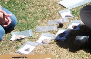
Figure 3: An assemblage of artifacts, specifically red-on-buff pottery sherds and lithics from Canal One (Riverview). Photo courtesy of Heidi Emma (2012)
Southeast of these sites is Pueblo Grande, a village which possessed a local pottery industry as well (Abbott 2000: 18). However, here ceramic production was on a much more prodigious scale. For example, chemical analysis has revealed that a wide spectrum of Salt River sand types and outcrops were employed for locally produced pottery fabrics such as plainware (Mitchell and Brunson-Hadley 2001: 46; Abbott 2000: 79-83). Such data underscores the scope of their ceramic industry in comparison to their contemporaries (cf Abbott 2000: 147-151). Yet, excavations also revealed an unusually high quantity of the socially coveted redware (cf Fig. 3), a non-local ceramic unobserved in contexts at Casa Buena and the Grand Canal Ruins (Abbott and Walsh-Anduze 1995: 93-94; Abbott and Schaller 1994: 100). Thus, it may be plausible to deduce that Pueblo Grande was a ‘regional’ socioeconomic center — but to what end?
Irrigation Alliance
Uniquely, all three of these sites shared two CS-2 canals in what is labeled the ‘North Occupation Zone’ (See Abbott 2000: 87). However, what is captivating is the fact that Pueblo Grande is strategically situated at the head gates of both canals — tactically in a position to exhibit influence over the other two sites if desired (Earle and Doyel 2008: 34; cf Yoffee 2004: 11-12). What can be said then? Perhaps the ruins of the Grand Canal are in actuality a colony of Casa Buena ‘pioneers’, both of which formed an axis with Pueblo Grande — itself responsible for the water management and irrigation development of the area (cf Abbott 2000: 147; Fish et al. 1992a: 15; Morgan 1994: 108; Abbott et al. 2003: 15). Under such circumstances, Casa Buena and the Grand Canal Ruins could be viewed as the ‘peripheral’ to a Pueblo Grande ‘center’ (See ‘site hierarchy’ in Renfrew and Bahn 2008: 184).
Equally, Pueblo Grande may have used their ‘water rights’ as leverage on neighboring polities to compel ‘membership’ in a canal system they monopolized (See Abbott and Schaller 1994: 101). To be sure, it has been suggested that disputes over ‘canal integration’ formed the foundation of intersocial organization for the early Classic Period (Abbott et al. 2003: 15). Moreover, such ‘interpolity transactions’ may explain the disparities between Pueblo Grande and Casa Buena/Grand Canal Ruins pottery types (cf Maya ‘interpolity competition’ in Rice 2009: 123). For example, it has been suggested that redware exchange was used in a ‘reciprocal’ manner between village families (Abbott 2000: 139-140; cf Renfrew and Bahn 2008: 360-361).
Considering its value, however, it is equally plausible that redware was a form of payment for services rendered from one village to another or a symbol of respect to the social hierarchy of a community (cf ‘Hohokam chiefdom’ in Earle and Doyel 2008: 33). Thus, it may be posited that the Pueblo Grande-Casa Buena-Grand Canal Ruins’ sector constituted an agricultural league, consisting of semiautonomous villages bound by a common need for water (cf Yoffee 2004: 11-12).
Early Irrigation and the complexities of a Civilization
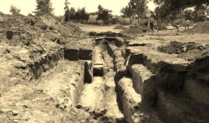
In the past, archaeologists interpreted the Hohokam ‘canal social system’ (see above) as a product of diffusion from pre-Columbian Mexican cultures (Foster 2012: 39). However, this has been disputed as radiometric dating indicates that the earliest Hohokam canal — a ‘small ditch’ in the vicinity of Riverview — was constructed during the 1st century AD (Earle and Doyel 2008: 31; contra Fig. 4). In addition, researchers have concluded that the Hohokam of the Formative Period (c. AD 1-750) were ‘dependent on irrigation’ as early as the middle of the first millennium AD (Phillips 2009: 692). This is in no doubt a result of Preclassic subsistence requirements brought on by the gradual sedentism of the Sacaton Phase (c. AD 750-1050) (See Phillips 2009: 698). It is therefore logical to assume that the demands placed on older, less sophisticated canals would be too great. Consequently, a ‘Preclassic’ construction boom in ‘single ditch’ canals took place, thus setting the stage for the Classic Period integration (Earle and Doyel 2008: 31-32).
__________________________________

Figure 4: Riverview’s Canal One excavation (in progress) as it appeared on April 16, 2012. At this point during the excavation it was assumed that there were actually two canals running parallel to each other, hence the great length of the trench. Regardless, after weeks of digging — old school archaeological style — our sixteenth trench intercepted the first Prehistoric waterway at the site. Of course, the full scope of the discovery was not fully realized for several weeks. Photo by Paul J. De Mola (2012)
__________________________________
Interestingly, it appears that the causes behind Preclassic irrigation development parallel the socioeconomic factors which drove the hydraulic engineering of the Classic Period. Moreover, while archaeology has definitely increased our understanding of Hohokam irrigation and agriculture, the various evidences presented here seem to suggest that one cause was the catalyst for all changes: sedentism. However, we should not assume that the Hohokam were an entirely sedentary culture at any stage of their evolution. For example, surveys of the Tucson landscape have indicated that the mountainous topography was unsuitable for the type of large scale irrigation seen in the north occupation zone. This may be supported by the late arrival of irrigation in this area (Earle and Doyel 2008: 31).
In addition, ethnographic studies have inferred that the Tucson Hohokam made use of both anthropogenic and natural reservoirs to store water for agricultural purposes (Bayman 2001: 273-273; Fish et al. 1992b: 43). However, could not a mobile community utilize ‘large water holes’ while foraging too? Perhaps certain Hohokam ‘sects’ were only semi-sedentary and had a lifestyle that reflected their Paleoindian forbearers (See Browman et al. 2009: 313-321). This might better explain the motivation behind their seasonal camps (see above). In comparison, neighboring cultures such as the Mogollon coped with hilly landscapes through an institutionalized synthesis of agricultural and hunter-gatherer economies (Shaw and Jameson 1999: 45; Darvill 2008: 286). Consequently, it may be postulated that the Tucson area Hohokam were not nearly as sedentary as their Phoenix counterparts and were, in point of fact, quite mobile.
Endings
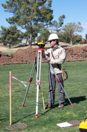
Figure 5: Here, Paul Joseph De Mola is measuring strata column elevation for trench nine using an automatic level (Riverview). Photo courtesy of Dutch Duering (2012b)
Throughout this essay, I have discussed how archaeological survey and excavation (Fig. 5) has been used to change our understandings of agricultural patterns by highlighting some of the changes that the Hohokam brought to their own diets. Moreover, I have examined various excavated sites to display how Hohokam irrigation was critical to Preclassic and Classic societies. These two aspects of Hohokam culture while distinguishable are, of course, inseparable. In fact, it may be said that canals formed the thread that interweaved Hohokam agricultural and irrigation strategy. That is to say, agriculture was as intertwined with irrigation as day is to night. To this end archaeological research has been indispensable in our knowledge of the Hohokam as a ‘people’.
Dr. Jerry Howard (2012, pers. comm.) has stated that the expansion of settlements during the latter Classic Period caused a subsequent overexploitation of resources during the Polvoron Phase (c. AD 1375-1450) setting the stage for an ecological crisis. Tragically, with numerous droughts came a decline in irrigation, which in turn caused a collapse of the already strained agricultural system. Subsequently, villages were abandoned thereby reducing human power to maintain operating canals which only further depleted food sources. As a result, the entire Hohokam economic structure descended into social chaos. Ergo, it may be argued that at the height of their civilization — during the great days of the early Classic Period — the Hohokam were inadvertently sowing the seeds of their own demise.
Notes
- The recent decision of the city of Mesa to redevelop the Riverview Golf Club and Park resulted in the State’s first serious archaeological fieldwork in nearly four years. Consequently, a grant to conduct cultural research management was extended to Dr. Jerry Howard (ASU) for a short three week season in April 2012. Additional funding for what became known as the Riverview Archaeological Project was commensurate to any ‘significant discovery’ of prehistoric value, such as Hohokam features (Howard 2102, pers. comm.; See Nelson 2012; cf Renfrew and Bahn 2008: 584).
- At the heart of Hohokam life was the dependence their social communities placed upon desert farming in which canal systems played an essential role. A chief objective of the Riverview Archaeological Project was the methodical recording of any Hohokam canals—including their location, number, age, and configuration—with the intention of enabling the researchers to better ‘reconstruct the evolution’ of Canal System One (CS-1) (Howard 2012. pers. comm.). Because of its location south of the Salt River, Riverview was suspected of Hohokam agency. This theory was postulated by Dr. Jerry Howard, a leading authority of Hohokam culture and expert on Classic Phase irrigation.
- Much of the excavation at Riverview was in the form of ‘intercept trenches’. Ingeniously utilized by Dr. Howard and his CRM team, the raison d’être of intercept trenches is rather straightforward: intercept archaeological features at a perpendicular angle. In the case of Riverview, east-west ditches were cut in the hope of intersecting prehistoric canals flowing south from the Salt River — a method that bore much fruit for the team from ASU.
-
Since the Hohokam disposed of their rubbish in waterways, the most indicative evidence for a canal is artifacts of which pottery is the most common (Medchill, 2012, pers. comm.). However, it must be noted that excavation is not an exact method of science. For example, after the first two weeks of digging at Riverview, only two shards were found in the first ten intercept trenches. These specimens were identified as Classic Hohokam red-on-buff ware (Howard 2012, pers. comm.). Unfortunately, because of the dearth of material culture from these trenches, it was concluded that none of them intersected a canal.
- Simple in situ observation of stratigraphy during excavation is an essential component of Hohokam fieldwork (Greene 2002: 88 – 90). During data recovery, any indications of leaching (i.e. caliche), rust and charcoal may aid in the detection of hidden contexts. For example, charcoal—essentially a pyrolitic organic residue—may imply the presence of a kiln or even a crematory, as was briefly believed to be the case within Riverview’s Canal One (Hurcombe 2007: 140; contra Duering 2012a, pers. comm.).
- Petrographic and chemical analyses of soil composition (e.g., sandy silt with high levels of silica, clay with bioturbation), equips Hohokam ceramicists with a cross-referencing tool to help determine the provenience of fabrics used in ceramic typologies (Phillips 2012, pers. comm.; Booker 2102, pers. comm.). For example, are the vegetal inclusions found within a piece of Redware consistent with botanical conditions from this or another site? What is the precise mineral source of the clay that a Hohokam potter used in a red-on-buff bowl (See Banning 2000: 175)? Ultimately, answers to these questions may aid in identifying socioeconomic trade patterns and anomalies.
- In theory, canals are known for the exquisite ‘mottled strata’ they leave in soil deposits. That is to say, heterogeneous sediments possessing low levels of sand that are deposited through channeled river and appear as ‘churned’ color patterns on trench walls (Phillips 2012, pers. comm.; See also Huckleberry 2006: 349). This was most vividly illustrated recently at Riverview’s trench sixteen (Fig. 4) which was also accompanied by a wide prehistoric artifact distribution, lending support to the opinion that this was indeed a canal of Hohokam origin.
- It should be noted, however, that Hohokam canals were so well designed that they were frequently reused by historical (later) engineers. At Riverview, their post-colonial reuse is evidenced by the presence of bioturbation by freshwater anthropods. For example, a cavity located immediately below the topsoil in trench thirteen’s stratigraphy implied the presence of crayfish—a nonnative crustacean which entered Salt River reservoirs in historical times (Duering 2012a, pers. comm.; See AGFD 2012).
Bibliography
Abbott, D. R., 2000. Ceramics and Community Organization Among the Hohokam. First ed. Tucson: University of Arizona Press.
Abbott, D. R., Breternitz, C. D. & Robinson, C. K., 2003. Challenging Conventional Conceptions. In: D. R. Abbott, ed. Centuries of Decline during the Hohokam Classic Period at Pueblo Grande. First ed. Tucson: The University of Arizona Press, pp. 3-23.
Abbott, D. R. & Schaller, D. M., 1994. Ceramics Among the Hohokam: Modeling Social Organization and Exchange. In: D. Scott & P. Meyers, eds. Archaeometry of Pre-Columbian Sites and Artifacts. First ed. Los Angeles: Getty Conservation Institute, pp. 85-112.
Abbott, D. R. & Walsh-Anduze, M. E., 2005. Temporal Patterns without Temporal Variation: The Paradox of Hohokam Redware Ceramics. In: B. J. Mills & P. L. Crown, eds. Ceramic Production in the American Southwest. First ed. Tucson: University of Arizona Press, pp. 88-114.
AGFD, 2003. Crayfish Brochure. Arizona Game and Fish Department. [Online]
Available at: http://www.azgfd.gov/pdfs/i_e/Crayfish_Brochure.pdf
[Accessed 1 July 2012].
Aicher, P. J., 1995. Guide to the Aqueducts of Ancient Rome. First ed. Wauconda: Bolchazy-Carducci Publishers, Inc.
Banning, E., 2000. The Archaeologist’s Laboratory: The Analysis of Archaeological Data. First ed. New York: Kluwer Academic Publishers.
Barnes, E. & Breternitz, C. D., 1988. Excavations at Casa Buena: Changing Hohokam Land use along the Squaw Peak Parkway. Soil Systems Publications in Archaeology, II(11), pp. 49-56.
Bayman, J. M., 2001. The Hohokam of Southwest North America. Journal of World Prehistory, XV(3), pp. 257-311.
Blythe, A. A., 2009. Social Differentiation in Animal Use and Subsistence: A Case Study of the Marana Platform Mound. First ed. Ann Arbor: ProQuest, LLC.
Browman, D. L., Fritz, G. J., Watson, P. J. & Meltzer, D. J., 2009. Origins of Food-Producing Economies in the Americas. In: C. Scarre, ed. The Human Past: World Prehistory & the Development of Human Societies. Second ed. London: Thames & Hudson, Ltd, pp. 306-349.
Brown, T. S., 1988. The Transformation of the Roman Mediterranean, 400-900. In: G. Holmes, ed. The Oxford Illustrated History of Medieval Europe. First ed. Oxford: Oxford University Press, pp. 1-61.
Darvill, T., 2008. Oxford Concise Dictionary of Archaeology. Second ed. Oxford: Oxford University Press.
De Mola, P. J., 2012. Looking south across Canal One. The former cross-trench sixteen now appears to be intercepting a potential second canal. The excavators may be observed working to the immediate southwest of the landscape. [Photograph] (Riverview Archaeological Project).
Duering, W. D., 2012a. Personal Communication. In the field cartography and geospatial engineering instruction. As well as general conversations on the Riverview Archaeological Project, including its sedimentology and artifacts. [Interview] (March 29-April 5, 2012).
Duering, W. D., 2012b. Paul De Mola measuring strata column elevation at trench nine. [Photograph] (Riverview Archaeological Project).
Earle, T. & Doyel, D. E., 2008. The Engineered Landscapes of Irrigation. In: L. Cliggett & C. A. Pool, eds. Economies and the Transformation of Landscape. First ed. Lanham: Alta Mira Press, pp. 19-46.
Elson, M. D., 1998. Expanding the View of Hohokam Platform Mounds: An Ethnographic Perspective. First ed. Tucson: University of Arizona Press.
Emma, H., 2012. Assorted lithics and shards from Canal One. [Photograph] (Riverview Archaeological Project).
Eppinga, J., 2002. Nogales: Life and Times on the Frontier. First ed. Charleston: Arcadia Publishing.
Fish, S. K., 2000. Hohokam Impacts on Sonoran Desert Environment. In: D. L. Lentz, ed. Imperfect Balance: Landscape Transformations in the Precolumbian Americas. First ed. New York: Columbia University Press, pp. 251-280.
Fish, S. K., Fish, P. R. & Madsen, J. H., 1992a. Early Sedentism and Agriculture in the Northern Tucson Basin. In: S. K. Fish, P. R. Fish & J. H. Madsen, eds. The Marana Community in the Hohokam World. First ed. Tucson: University of Arizona Press, pp. 11-19.
Fish, S. K., Fish, P. R. & Madsen, J. H., 1992b. Parameters of Agricultural Production in the Northern Tucson Basin. In: S. K. Fish, P. R. Fish & J. H. Madsen, eds. The Marana Community in the Hohokam World. First ed. Tucson: University of Arizona Press, pp. 41-52.
Foster, W. C., 2012. Climate and Culture Change in North America AD 900-1600. First ed. Austin: University of Texas Press.
Gibbon, G. E., 1998. Archaeology of Prehistoric Native America: An Encyclopedia. First ed. Oxon: Taylor & Francis Group.
Greene, K., 2002. Archaeology: An Introduction. Fourth ed. London: Routledge.
Gropper, S. S. & Smith, J. L., 2005. Advanced Nutrition and Human Metabolism. Sixth ed. Stamford: Wadsworth Cengage Learning.
Hodgson, W. C., 2001. Food Plants of the Sonoran Desert. First ed. Tucson: University of Arizona Press.
Howard, J., 2012. Personal Communication. Regular in the field conversations on the Riverview Archaeological Project, Hohokam culture and interpretion of material remains. [Interview] (March 29-April 5, 2012).
Huckell, L. W. & Toll, M. S., 2004. Wild Plant Use in the North American Southwest. In: P. E. Minnis, ed. People and plants in ancient western North America. First ed. Tucson: University of Arizona Press, pp. 37-114.
Huckleberry, G., 2006. Sediments. In: J. Balme & A. Paterson, eds. Archaeology In Practice: A Student Guide To Archaeological Analyses. Malden: Blackwell Publishing, pp. 338-361.
Hurcombe, L. M., 2007. Archaeological Artefacts as Material Culture. First ed. London: Routledge.
IAE, 2008. Interpreting Archaeological Evidence: Material Culture and Environment. (Level 2 course reader). First ed. Leicester: University of Leicester.
Justice, N. D., 2002. Stone Age Spear and Arrow Points of the Southwestern United States. First ed. Bloomington: Indiana University Press.
Kwiatkowski, S. M., 2003. Evidence for Subsistence Problems. In: D. R. Abbott, ed. Centuries of Decline during the Hohokam Classic Period at Pueblo Grande. First ed. Tucson: University of Arizona Press, pp. 48-69.
Lockard, C. A., 2008. Societies, Networks, and Transitions: A Global History (Volume I: To AD 1500). First ed. Stamford: Cengage Learning.
Logan, M. F., 2002. The Lessening Stream: An Environmental History of the Santa Cruz River. First ed. Tucson: University of Arizona Press.
Medchill, B., 2012. Personal Communication. Instruction in various field methods and their logical applications, including sedimentology. General conversations on the Riverview Archaeological Project. [Interview] (April 2-5, 2012).
Meiguoren, 2012. Mesa Grande Hohokam Ruins Arizona. (Photo) Available at: http://commons.wikimedia.org/wiki/File:Mesa_Grande_Hohokam_Ruins_Mesa_Arizona.jpg.
[Accessed 12 December 2012].
Milner, G. R., 2009. Complex Societies of North America. In: C. Scarre, ed. Our Human Past: World Prehistory & the Development of Human Societies. Second ed. London: Thames and Hudson, pp. 678-715.
Mitchell, D. R. & Brunson-Hadley, J. L., 2001. An Evaluation of Classic Period Hohokam Burial and Society: Chiefs, Priests, or Acephalous Complexity? In: D. R. Mitchell & J. L. Brunson-Hadley, eds. Ancient Burial Practices in the American Southwest: Archaeology, Physical Anthropology, and Native American Perspectives. First ed. Albuquerque: University of New Mexico Press, pp. 45-67.
Moerman, D. E., 2010. Native American Food Plants: An Ethnobotanical Dictionary. First ed. Portland: Timber Press, Inc.
Morgan, W. N., 1994. Ancient Architecture of the Southwest. First ed. Austin: University of Texas Press.
Nelson, G., 2012. Vote signals end for Mesa’s Riverview Golf Course. [Online]
Available at: http://www.azcentral.com/community/mesa/articles/2012/02/21/20120221vote-signals-end-riverview-golf-course.html
[Accessed 25 November 2012].
Phillips, B., 2012. Detailed in-the-field lectures on the geomorphology and sedimentology of Riverview and the greater Phoenix area. [Interview] (March 29-April 5, 2012).
Phillips, D. A., 2009. Adoption and Intensification of Agriculture in the North American Southwest: Notes Toward a Quantitative Approach. American Antiquity, LXXIV (4), pp. 691-707.
Renfrew, C. & Bahn, P. G., 2008. Archaeology: Theories, Methods and Practice. Fifth ed. London: Thames & Hudson, Ltd.
Rice, P. M., 2009. Late Classic Maya Pottery Production: Review and Synthesis. Journal of Archaeological Methods and Theories, XVI (2), pp. 117-156.
Scupin, R. & DeCorse, C. R., 2003. Anthropology: A Global Perspective. Fifth ed. Upper Saddle River: Pearson Education.
Shaw, I. & Jameson, R., 1999. A Dictionary of Archaeology. First ed. Oxford: Blackwell Publishers, Ltd.
Sheridan, T. E., 2000. Human Ecology of the Sonoran Desert. [Online]
Available at: http://www.eebweb.arizona.edu/faculty/Bonine/Sheridan_NatHistSonDesert2000_HumanEcologySonoranDesert_105-118.pdf
[Accessed 16 August 2012].
Strobl, B., 2012. Personal Communication. Instruction in interpreting archaeological remains and working with a backhoe. Sporadic discussions on the Riverview Archaeological Project [Interview] (March 29-April 5, 2012).
Smith, J., 2004. Making Water Flow Uphill: The History of Agriculture in Mesa, Arizona. First ed. Mesa: Mesa Historical Society.
Wayne, E., 2006. Popping Amaranth. (Photo) Available at: http://commons.wikimedia.org/wiki/File:Amaranth_sp_2.jpg.
[Accessed 11 December 2012].
Webster, D. & Evans, S. T., 2009. Mesoamerican Civilization. In: C. Scarre, ed. The Human Past: World Prehistory & the Development of Human Societies. Second ed. London: Thames & Hudson, Ltd, pp. 594-639.
Yoffee, N., 2004. Myths of the Archaic State: Evolution of the Earliest Cities, States, and Civilizations. First ed. New York: Cambridge University Press.
Acknowledgements
The esteemed cultural resource management team from Arizona State University: archaeologist(s) Carla Booker, Brian Medchill and Bert Strobl who were gracious enough to take the time in giving me a ‘trench course’ in stratigraphy, sedimentology and the logistics involved in ‘canal hunting’.
An expression of gratitude must be paid to my Aunt Faith who furnished me with the camera for my ventures, and my first cousin Heidi who graciously assisted me with photography.
Special mention needs to be made to archaeologist Walter ‘Dutch’ Duering and archaeobotanist Bruce Phillips, for providing me with an intense training experience in modern cartography and geoarchaeology, respectively.
A very special thank you must be expressed to Dr. Jerry B. Howard (ASU) who managed to imbue this young man with a deep appreciation for the pre-Columbian southwest.
For additional information on the Riverview Archaeological Project, Mesa Grande or the Hohokam contact:
Dr. Jerry B. Howard, Curator of Anthropology
Arizona Museum of Natural History
480-644-2230
http://azmnh.org/
Cover Photo, Top Left: Detail of the Casa Grande Great House remains. Greg Hume, Wikimedia Commons


