There was a deliberate geometry to how they built their city. The streets ran exactly east to west or north to south. On each city block, which measured exactly 100 meters by 100 meters, there were 4 dwellings and 4 ponds, with each rectangular pond located on the north-eastern side of each dwelling. The dwellings were erected on mounds of earth, higher than the rice fields, so they wouldn’t flood during the rainy season – and so were the roads. The temples were built of stones or bricks, and the entrance faced eastward, if the temple was dedicated to Shiva, and westward if it was dedicated to Vishnu. This urban landscape extended for 35 square kilometers – and may have been home to a million people.
This was the city of Angkor, built more than 1,000 years ago.
For years, archaeologists who studied Angkor focused on its temples – because they alone survived the centuries. Everything else – including royal palaces and ordinary people’s homes – was built of wood and vanished.
But now, archaeologists are using a tool that allows them to retrace the streets of ancient cities – by pealing away the forests that cover them. Damian Evans, a landscape archaeologist from the University of Sydney in Australia, first learned about something called LiDAR from Arlen Chase, who was the first to use this technology in archaeological research in Mesoamerica. LiDAR (Laser Interferometry Detection and Ranging) is a system that uses laser pulses to reveal what the earth’s surface looks like below heavily forested areas. Chase used LiDAR in Belize to prove that the ancient Maya had built terraced agricultural fields – while Evans with his team were the first to use it in Asia. Evans’ project cost $250,000 and took 20 hours to survey 300 square kilometers around ancient Angkor. It would have taken years to clear this many kilometers with a machete.
What they found with LiDAR was staggering.
“It’s just amazing,” said Michael Coe, a world-renowned archaeologist who authored a book about Angkor. “In the case of Angkor, we knew where the temples were, but we never really knew what it was like as a city where people lived.”
In addition to creating a map of Angkor’s streets for the first time, archaeologists also found some strange coil-shaped features on the southern side of Angkor Wat – in an area that is now covered by forest and landmines. These embankments are 10-15 meters high and were created in a spiral pattern, with each bank measuring a meter in height. “We are not sure what they are,” Evans said.
One of the most important discoveries, however, was that Angkor Wat was actually bigger geographically than what had previously been thought. Evans and his team found that the city blocks extended far beyond its moat. “We found that this nicely formally planned grid extends for 35 square kilometers, rather than the 9 kilometers that had previously been mapped from the ground,” he said. “Angkor has been considered to be (among the) cities enclosed by moats or walls, but we found that the town area of the city grids extends far beyond the moat spaces.”
The implication is that Angkor was likely home to a significantly larger population than what had previously been assumed. We know, from Chinese sources, that the kings of Angkor kept censuses. Every year or two, the king would invite a person from every household in the kingdom to come to the city to be counted, according to Coe. The kings of Angkor collected this information in order to know how much they could collect in taxes each year – at the time, taxes were paid in rice. However, the census numbers were written down on paper and have not survived. Estimating the population of Angkor nowadays, therefore, is a guesstimate at best. However, knowing that the city extended for 35 square kilometers means that it may have been home to as many as 750,000 to a million inhabitants, according to the new research. “Angkor was a city the size of New York and that’s impressive in the ninth century,” said Francisco Goncalves, the president of McElhanney Indonesia, the company that adapted the LiDAR system for the Cambodian archaeology project.
Knowing this has shed new light on what may have caused the demise of Angkor. Scholars now suggest that as the city’s population grew, it likely became increasingly hard for the farmers from the countryside to support the urban dwellers. “You would have had a very large population that was not devoted to producing rice,” said Evans. “So they relied on consistent yields of the agricultural hinterland.” According to Coe, a large population may have also been responsible for the decision to move the Khmer capital to another area in the 14th century.
“They overused the land and probably caused a great amount of erosion, clogged up the canals and the whole irrigation system would have collapsed,” he said, adding that this is what happens “when populations grow beyond the agricultural capacity of the land.”
_________________________________
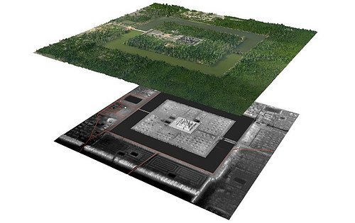
A view of Angkor Wat and its immediate environs using LiDAR. Top layer: Digital orthophoto mosaic. Bottom layer: LiDAR digital terrain model, revealing what the eye does not see. Red lines indicate modern linear features including roads and canals. Courtesy Damian Evans
_______________________________________________________________________________________________________________________
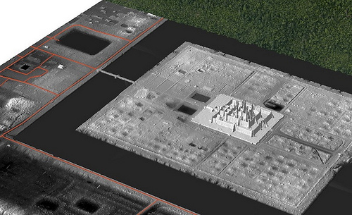
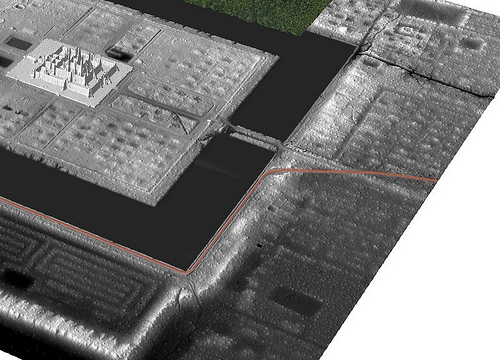
Above and below: LiDAR digital terrain model detail. Unseen ancient features come to view through the new technology. Courtesy Damian Evans
________________________________________________________________________________________________________________________
A LOST CITY
In addition to the area around Angkor itself, archaeologists also surveyed a site called Phnom Kulen hill, a 25 x 15 kilometer plateau that is located about 40 kilometers northeast of Angkor. It was on this hill that they discovered another urban landscape – a landscape they say corresponds to the 8th – 9th century city named Mahendraparvata, one of the first capitals of the Khmer Empire, identified in some inscriptions on the doorposts of Angkor. These inscriptions describe a former capital city which was established by king Jayavarman II in the year 802. It was this area that captured media attention all over the world with air segments about Cambodia’s “lost city.”
In the article that Evans and his team just published in the Proceedings of the National Academy of Sciences, they described their discovery as “an entire, previously undocumented cityscape etched into the surface of the mountain beneath the forest. This newly mapped urban landscape,” they went on to say, “was previously known primarily from written inscriptions.” However, according to Evans and JB Chevance, the program manager from the Archaeology & Development Foundation who worked with Evans on the Lidar project, the term “lost city” is actually a “misnomer.” The location of the pre-Angkorian capital has been known since the beginning of the 20th century because of the existence of dozens of temples on the Phnom Kulen mountain, including one pyramid temple that “looked very much like a royal temple of the King,” according to Evans and Chevance. But thanks to the LiDAR survey, archaeologists “moved from a situation where we had points on a map to the entire urban fabric that connects these points,” Evans said. As at Angkor, here the LiDAR was used “to see through” the cover of cashew nut plantations and forest foliage to create a three-dimensional map of the topography. The archaeologists mapped major and minor roads – stretching for 8 kilometers along east-west or north-south directions – as well as canals, dikes and ponds. The map of Mahendraparvata also confirmed the location of the 600 x 40 meter royal palace, which had been built of wood and disappeared. “With the LiDAR, we now have a very precise image of that site. It’s one of the main sites because all the roads are directed to it,” Chevance said.
In addition to this, archaeologists identified several geographically-oriented topographical anomalies that they could not identify or explain, according to Chevance. The next step will be to explore these features on the ground – not an easy task as large areas of the mountain have not been cleared of landmines.
Like Angkor, the city of Mahendraparvata was eventually abandoned, the capital moved to Angkor, and Mahendraparvata became a point of interest only for Buddhist pilgrims in the 16th century, according to Chevance. Indeed, there seems to be a tradition in Cambodia of abandoning the capital city and re-establishing it in another location. After Angkor, Cambodia’s capital moved to Lonvek in the 15th century, back to Angkor for a brief period in the 16th century, then to Oudong in the 17th century, and eventually to present day Phnom Penh in the 19th century. Perhaps, Chevance hypothesized, each king wanted to have the capital in his own hometown. Or perhaps the location of the capitals in different parts of the kingdom was testimony to the varying powers of the different royal houses, Evans said.
“People look at the movement of the royal court and imagine that it implied the movement of a large number of people,” Evans said, explaining that this is not necessarily what happened. “It could just be competing royal houses where one royal house gains power over another one.”
_________________________________________________________________________________________
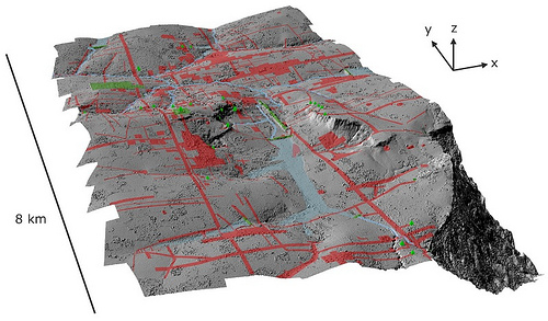
Shaded relief map of terrain beneath the vegetation in the Phnom Kulen area, with elevation derived from the LiDAR digital terrain model. Green denotes previously-documented archaeological features; areas shaded red contain newly-documented features indicative of an extensive urban layout. Data and image courtesy Archaeology and Development Foundation – Phnom Kulen Program
_________________________________
LOOKING AHEAD
Evans is currently engaged in raising more funds to continue exploring Cambodia with LiDAR. One of the locations he would like to survey is the largest enclosing wall in Southeast Asia, located in the Preah Vihear Province in the north of Cambodia. This earthen wall, called Preah Khan of Kampong Svay, is 5 x 5 kilometers in length and 40 meters tall in some areas – yet no one knows why it’s there.
“It’s huge – absolutely huge,” Evans said. “It’s kind of in the middle of nowhere.”
Archaeologists in neighboring Thailand are also becoming interested in the technology. Goncalves is looking into cooperating with Thai archaeologists to study ancient rice fields in the northeast of the country, an area now covered by forest – and to map the ancient road that once connected Angkor to the Siamese kingdom of Ayutthaya.
“A lot of that (road) has been obscured and taken over by the forest. There had to be settlements where people stopped,” he said
Overall, researchers said, Lidar will be just as revolutionary in archaeology as carbon dating – especially in tropical areas.
“Carbon dating gave us control of time, but what LiDAR does is it gives us control of space,” said Chase.
_______________________________________________________________________________________________________________________
Article Supplement
HOW LIDAR WORKS
LiDAR uses light to measure distance. That’s according to Francisco Goncalves, of the Jakarta-based company McElhanney, the group that adapted the technology to the Cambodian archaeology project.
“You know the position of the aircraft, you know the speed of light, and you measure the time that it takes for the Lidar’s laser signals to bounce back to the aircraft,” he explains.
“The laser signals don’t actually go through the vegetation, but there are so many of them that some find gaps in the leaves and make it all the way down to the forest floor. Scientists then analyze the data sets, discarding the shorter laser signals and keeping the ones that are longest, and create a pattern,” he said.
To conduct the Cambodian LiDAR survey, Australian archaeologist Damian Evans climbed into a helicopter from which seats had been torn out to make room for computers, batteries and a special display screen for the pilot – and slowly flew in a grid-like pattern, back and forth over the ancient city.
“It’s very difficult for pilots to fly this way,” he said. “Flying by the LiDAR instrument was a bit like playing a video game – the pilot had to keep looking at this screen and keep the helicopter icon within the circle in order to keep strictly in the flight path, which is a very different way for pilots to fly.”
But the new technology is not a panacea. It has its limitations.
“While laser signals can go through vegetation, water causes a problem because it doesn’t reflect the signal back, while foggy, smoky and cloudy weather conditions make the technology difficult to use,” Goncalves said.
______________________________________________________________________________________________________________________

LiDAR pod being installed on the helicopter at the Phnom Penh International Airport in Cambodia. Courtesy Christopher Cromarty of McElhanney
________________________________________________________________________________________________________________________
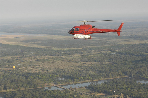
Helicopter with LiDAR attached during flight operations over Angkor in April 2012. Courtesy Francisco Goncalves of McElhanney
STUDYING ANGKOR FROM AIR AND SPACE
The temples of Angkor are spread out over such a large area, and are so perfectly symmetrical, that to truly appreciate them, it’s best to get up in the air. Nowadays, a popular way to do it is with a hot-air balloon.
But for archaeologists, it began with the aerial photograph.
At the end of the 1920s, when people first took to the sky, these photographs allowed French archaeologists to appreciate the vast scale of Angkor. “But back then, archaeologists were mostly interested in temples – not in how ancient Cambodian cities were laid out or how their irrigation systems functioned,” says Australian archaeologist Damian Evans.
Then, in the mid-1960s, came the first satellite images of Cambodia. These images were taken by American and Soviet spy satellites and were not declassified until 2003. Covering hundreds of square kilometers, satellite images widened the archaeologists’ perspective further. These pictures are particularly interesting to look at today, Evans says, because they reveal how the Cambodian landscape looked “before the Khmer Rouge messed with it.”
“Instead of respecting the remains of the Angkor period, they (the Khmer Rouge) tried to implement a whole new system of fields and canals and they tried to radically re-engineer the landscape –and they failed,” he said.
The satellite images that were taken before the Khmer Rouge came to power help present-day archaeologists to separate ancient topographic features from the more recent ones, Evans says.
Then came the first radar image, which was taken from the space shuttle in 1994. The radar stripped away some vegetation – like grasses and rice fields – but it was powerless against forests.
Finally, we have the LiDAR system, which can penetrate the thick forest canopies and allows archaeologists to create three dimensional models of the landscape under the vegetation.
_________________________________________________________________________________________
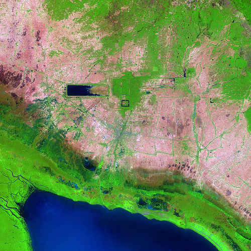
Angkor as seen from space, satellite image. NASA image
______________________________________________________________________________________________________________________
Subscribe to Popular Archaeology Premium. Available on all laptops and mobile devices, and still the industry’s best value at only $9.00 annually.


