
Nothing captures the world’s attention like a natural disaster — particularly a cataclysmic volcanic eruption. These can be perceived as primordial and fatalistic, a response to the extraordinary power of volcanism and our powerlessness in controlling such gigantic forces. Human memory records impressive volcanic events such as the 1883 Krakatau eruption in Indonesia and the AD 79 Vesuvius eruption in Italy. By comparison, relatively few have heard of the 1815 eruption of the Tambora volcano on the island of Sumbawa, also in Indonesia. Ten times more powerful than the eruption of Krakatau, it is now recognised as the largest explosive volcanic event in recorded history. It blasted 100 cubic kilometres of gases, rock and ash into the atmosphere and onto the island of Sumbawa and the surrounding Indonesian islands. Much more than this, the eruption changed, at least for a time, world climate. How did such a catacysmic event get by most of us? The answer lies in part with the invention of the telegraph in 1830. When Krakatau erupted in 1883 news spread quickly, and it became the first worldwide news story. In contrast, word of the 1815 Tambora eruption travelled no faster than a sailing ship, limiting its notoriety.
_______________________________________________________________________________________________________________________
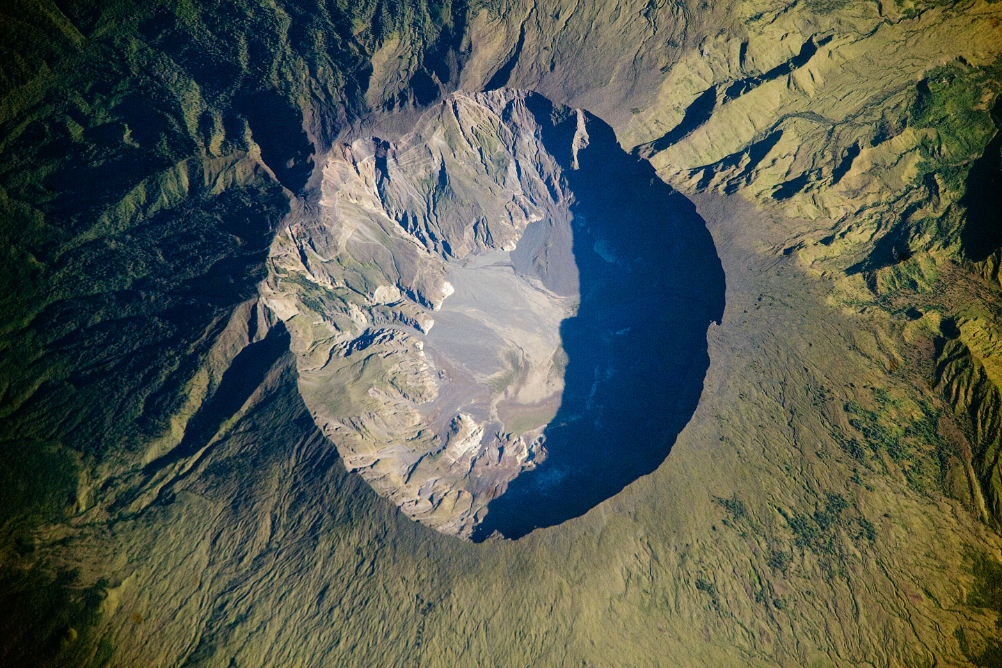 Orbital photograph of Tambora volcano with the huge caldera (6 km diameter and 1,100 m deep). Today the crater floor is occupied by an ephemeral freshwater lake, recent sedimentary deposits, and minor lava flows and domes from the Nineteenth and Twentieth Centuries. (Source: Earth Observatory, NASA).
_______________________________
Before the eruption, Tambora volcano was around 4,000 meters high, but in 1815 it literally blew its top off and was reduced in size to 2,851 meters (see image left, Tambora volcano’s present flat-top profile), producing a crater 7 kilometers in diameter and 1,100 meters deep.
A Disaster of Global Proportions
The volcano had never been active before in living memory, so the eruption was completely unexpected. In 1811, Java had fallen under British control, so we have contemporary reports of the eruption written by British resident agents, sea captains and army officers who were scattered along the East Indian Archipelago. These reports, in addition to modern-day volcanological and archaeological study, furnish fascinating insights into the nature and consequences of the eruption.
The great event began with ‘rumblings’ and a minor ash fall on April 5th, 1815. This was followed by a Plinian eruption column reaching heights of 33 kilometers, showering pumice and ash over the Island of Sumbawa, lasting for 2.8 hours. Between April 5th and 10th, the eruption became less intense, but the volcano continued to erupt and disperse small amounts of ash over the surrounding area. But this proved to be the “calm before the storm”. A larger, climactic eruptive phase began at 7 pm on April 10th with a 43 kilometer high Plinian column transporting material to a ‘great height’ and raining down ash and pumice on Sumbawa. This continued until around 10 pm when ‘violent winds’ were reported at Sangaar, a peninsula of Sumbawa, indicating a change in the eruptive style and marking the beginning of pyroclastic flows. These flows (a mixture of hot ash, dust and gas), affected the entire region around Tambora. They travelled down the volcano’s slopes at a rapid pace, destroying and killing everything, leaving deposits up to 20 m thick. (Carbonised tree trunks, rice and charred skeletons later recovered by excavators evidenced the high temperatures within these flows). Once they reached the sea, their impact generated a 4 meter high tsunami, which claimed lives along the northern cost of Sangaar before spreading out to areas of eastern Java.
_________________________________________________________________________________________
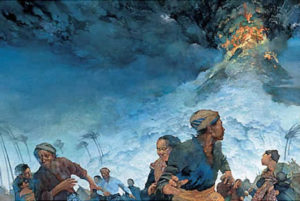
 An artist’s depiction of people fleeing the 1815 Tambora eruption (Source: Greg Harlin)
______________________________________________________________________________________________________________________
At the time of the eruption, there were an estimated 1800 settlements throughout the island of Sumbawa, all belonging to one of the six petty kingdoms or sultanates existing at the time (Sumbawa, Bima, Dompo, Sangaar, Pekat and Tambora).
_________________________________________________________________________________________
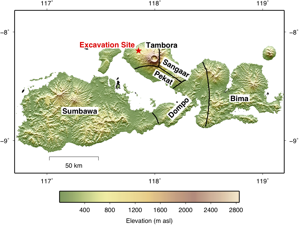 Digital Elevation Model (DEM) map of the Island of Sumbawa marked with the location of the excavation site (red star). The volcano’s location is identifiable by the crater. The six different kingdoms or sultanates are also highlighted (Data: 90m SRTM data)
_____________________________________________________________________________________________________________________
The kingdom of Tambora was a small and wealthy sultanate with about 10,000 inhabitants, located in the Sangaar peninsula on the volcano’s western flanks. Settlements were located inland, near rivers and a safe distance from seagoing pirates, with buildings constructed out of wood and bamboo. The people made a living by growing rice, mung beans, maize, and by trading items such as coffee, horses, beeswax, pepper, timber, incense and red dye.
But this all came to an end when the volcano erupted. The consequences were monumentally disastrous. The kingdom, along with a neighboring kingdom known as Pekat to its south, was buried under the ashfall, with no survivors. The unique language that was spoken became extinct, and the rest of Sumbawa was affected by an immediate famine and a lack of clean water. Survivors were reduced to eating dry leaves and selling their children to obtain rice. They were even driven to scavenge from the dead, digging up personal grave goods to use them for barter in an attempt to survive. Reports made by British sea captains describe the remains as ‘horrifying’: corpses were left lying about on roads, rice fields and beaches. There were so many of them that they couldn’t all be buried fast enough, becoming prey for dogs, pigs and birds. Not only humans were affected: 75% of the island’s livestock were also killed, and bird and bee colonies were wiped out by the ash.
Large parts of the Indonesian Archipelago were plunged into darkness for days as a consequence of the vast amounts of ash released by the eruption (See map below). The sounds of the accompanying explosions were audible as far away as Sumatra (2600 km) and in many places mistaken for cannon reports. The neighbouring islands of Bali, Lombok and south Sulawesi were hit badly; ash fall of up to 20-30 cm thick caused the collapse of buildings, trapping and killing those inside. Secondary effects such as famine, plague and epidemics plunged these islands into an abyss of poverty and misery.
________________________________________________________________________________________
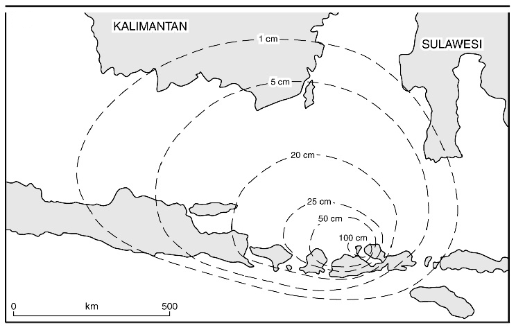 Isopach maps of the ash dispersal (Source: Oppenheimer, 2003: Fig 3b)
____________________________________________________________________________________________________________________
The eruption also had major global effects. It has been connected to the 1816 climactic phenomenon known as the `year without summer’. Fine ash particles and sulphate aerosols were carried high up into the atmosphere by the eruption column, where winds transported them around the globe. This veil of volcanic dust blocked out solar radiation, causing the earth to cool down. In the northern hemisphere, temperatures were abnormally low, causing a cold summer. This led to catastrophic flooding and famine worldwide. Many crops failed to ripen, and poor harvests led to famine, disease and socioeconomic problems. Europe was still recuperating from the Napoleonic Wars and already suffering from food shortages. The effects of the eruption exaggerated these problems further, leading to food riots in Britain and France. In Switzerland, the food crisis was so bad that people resorted to eating moss and cat flesh.
The months and years following the Tambora eruption were remembered in popular writing for the remarkable meteorological and optical phenomena produced by the spreading dust veil. In England, spectacular sunsets and orange, red, purple and pink twilights were observed. It is claimed that some of the paintings of J.M.W Turner, characterised by vivid oranges and red skies, were inspired by these volcanically induced stratospheric optics. It has been estimated that, overall, this eruption caused 11,000 deaths from direct volcanic effects and an additional 49,000 from famine and disease.
The Excavations
Despite the massive destruction caused by eruptions, volcanic disasters have a remarkable way of creating a lasting record of the things they ‘destroy’. This was no less true of the Tambora event. Like Mount Vesuvius and ancient Pompeii, Mount Tambora left a legacy of a people and the physical vestiges of their civilization intact, available for study and view for future generations. The scorching pyroclastic flows which had buried and otherwise dessimated the island kingdom of Tambora had also carbonised everything in their path, effectively ‘freezing’ both organic and inorganic forms in the moments of the disaster. It is this legacy that is now being excavated by archaeologists.
In 1980, P.T Veneer Products (a commercial logging company), discovered what appeared to be a site of human settlement to the northwest of the village of Pancasila, near the Tambora volcano. According to reports, the finds included pottery fragments (late 18th Century south China Porcelain), other pot sherds and bones. Others found coins, brassware and charred timber in the same region, all buried beneath a thick layer of volcanic deposits.
Finds like this continued to be discovered by locals, and in 2004 Volcanologist Haraldur Sigurdsson (University of Rhode Island) embarked to investigate these reports in this ‘museum gully’ as it had become known, which lay deep in the jungle on the volcano’s western flank. By using Ground Penetrating Radar, Sigurdsson was able to identify a complete house buried under 2-3 metres of pyroclastic flow and surge deposits. Although entirely charred, its form was well preserved, making it possible to distinguish beams and bamboo floors. Artefacts found inside the structure included Chinese porcelain, iron tools and copper bowls. Two victims were also discovered; one complete skeleton was found by the hearth in the kitchen area and the second, which was very badly damaged, identifiable only by the leg and a vertebra, was found on the porch.
Official excavations began in 2006 and continue to the present day. They have revealed a settlement that follows a linear composition, with houses spaced roughly 20 m apart, facing what was presumably a path or road through the site. The houses are built in the same style today, so it is possible to fairly accurately imagine how the kingdom of Tambora would have appeared (See photo below).
_________________________________________________________________________________________
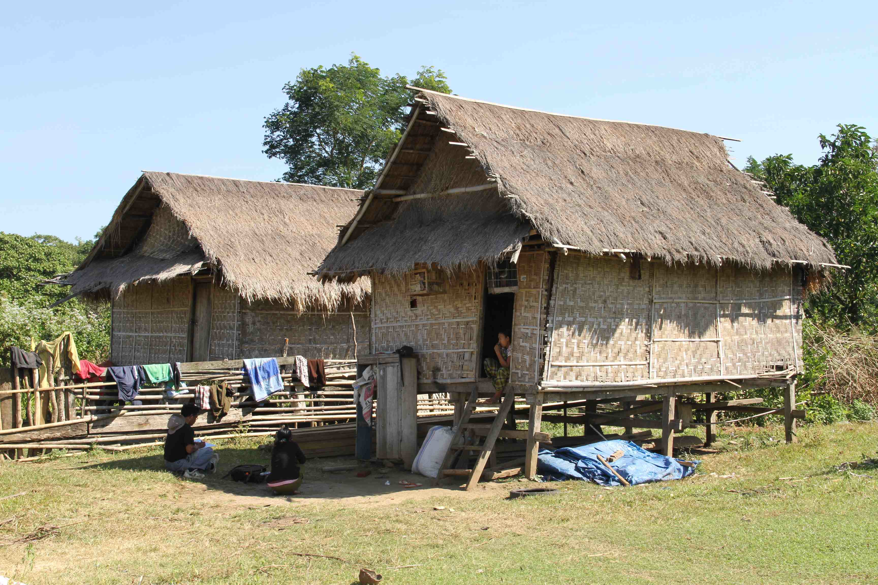 Photograph of a modern-day Sumbawan house. The buildings of the old kingdom of Tambora were constructed using the same techniques and in the same style as today (Photograph: Made Wita)
______________________________________________________________________________________________________________________
In 2008, a house was uncovered containing a male skeleton sitting upright, adorned with a copper tobacco box tied to his waist and a ceremonial spear at his side. He wore rings inlaid with precious stones, a bracelet on his wrist, and a large brass pendulum necklace around his neck. During the 2009 excavation season, another carbonised house was discovered, this time with a body lying just outside under the volcanic debris, with his left arm held up to his head perhaps in a (failed) attempt to protect himself from the falling pumice. In 2011, the remains of half of a house were identified, with a complete piece of the thatch wall remarkably well preserved. Some coarse-ware pottery and a tarsal bone from a goat were also found within the kitchen area.
_________________________________________________________________________________________
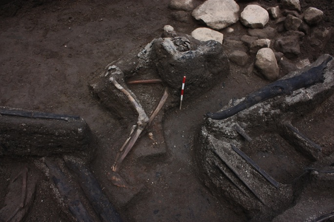 One victim who was discovered during the 2009 excavations. His left arm is held up to his head perhaps in a (failed) attempt to protect himself from falling pumice. The carbonised beams of the house are also shown (Photograph: Rik Stoetman)
______________________________________________________________________________________________________________________
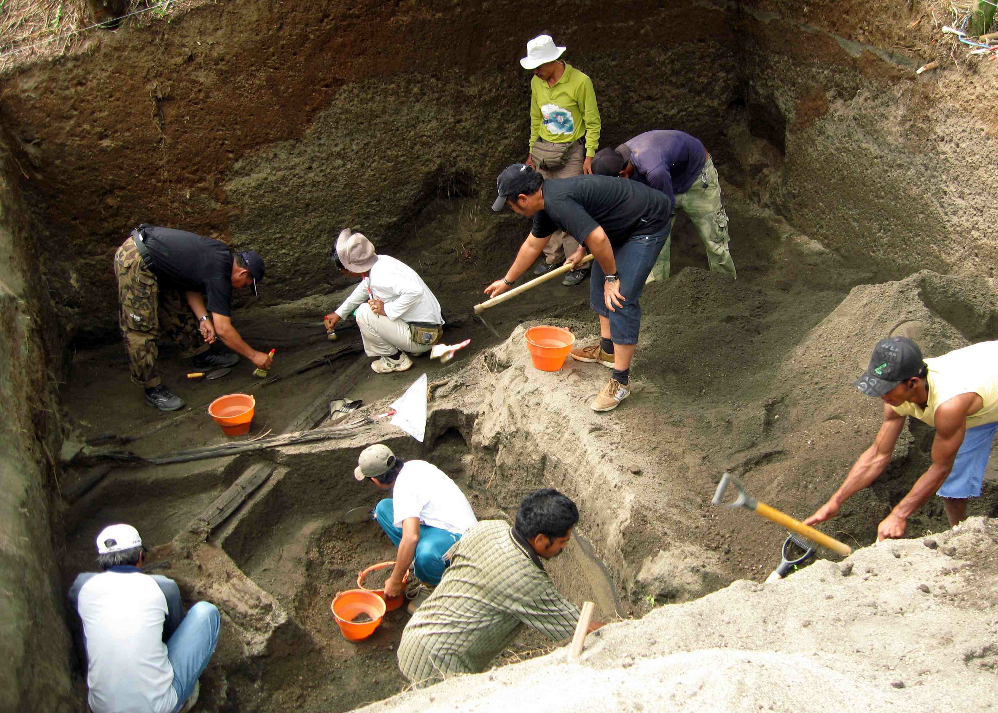 The 2011 excavation trench (Photograph: Emma Johnston)
_____________________________________________________________________________________________________________________
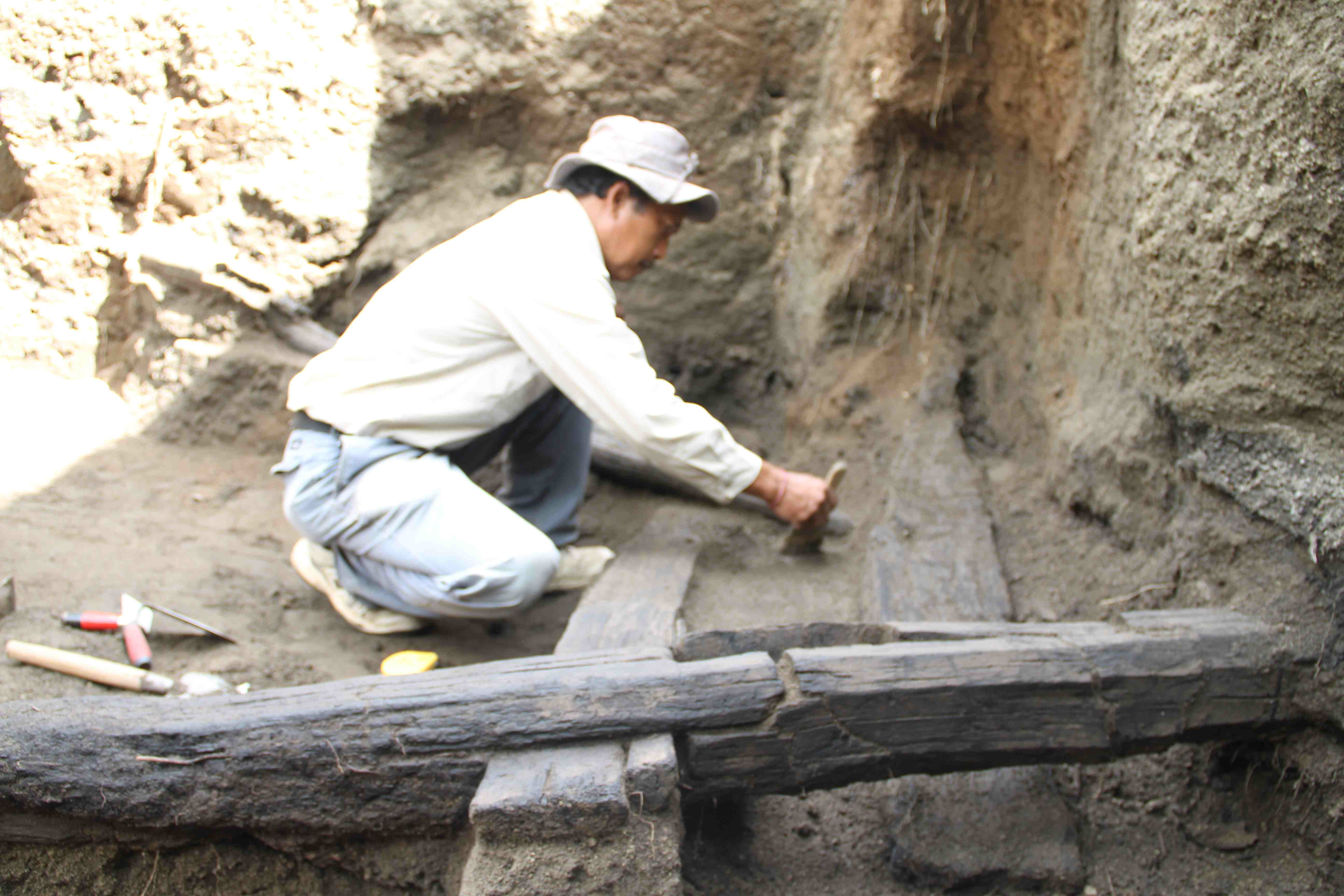 Excavating carbonised building beams (Photograph: Made Wita)
_____________________________________________________________________________________________________________________
Based on the artefacts found, particularly the many bronze objects and jewels, evidence suggests the site was once inhabited by the wealthy or an elite who had grown prosperous through trade. Historical evidence supports this theory, as Tamborans historically were known in the East Indies for their honey, horses, red dye and sandalwood. The design and decoration of the artefacts suggest that the Tamboran culture was linked to Vietnam and Cambodia.
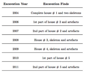 The excavations thus far have only scratched the surface. The rich finds suggest that there is much more waiting to be discovered at the site, now deservedly called ‘the Pompeii of the east’ (See table of finds, left). The excavations will continue in 2012 under the direction of Dr M. Geria of the Bali Institute for Archaeology.
Volcanic Deposits and Implications for Tambora
By examining the stratigraphy of the eruption deposits alongside the archaeological evidence, it is possible to identify the fateful events that took place at this site in April 1815 and brought an end to a thriving kingdom in the most horrific and deadly of circumstances.
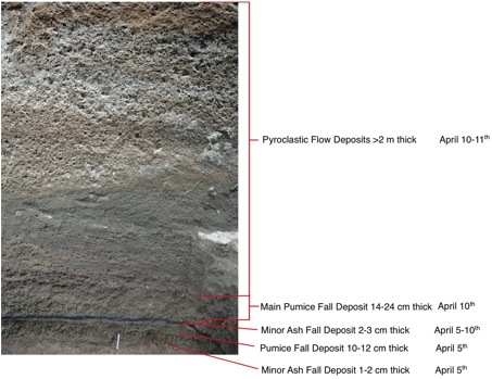
The Tambora eruption deposits cover a greater spatial area compared to that of other Plinian eruptions. Nonetheless, the deposits are substantially thinner than has been noted for other, less explosive eruptions despite the proximity of the settlement to the volcano (at Tambora the pumice fall is 14-24 cm thick vs. Pompeii where the pumice reaches thicknesses of 280 cm). It is likely that this influenced the people of Tambora to stay rather than flee the site as was done during the AD 79 Vesuvius eruption. For the inhabitants, this light but persistent ash and pumice fall would have been confusing, but probably no more than a nuisance, hindering the chores of everyday life (See figure below, the eruption deposit stratigraphy recorded at the excavation location during the 2011 season. Photograph: Emma Johnston).
 However, they would not have been aware of the impending danger, and as night fell on April 10th, the intensity of the eruption would increase and larger pieces of pumice would begin to rain down more swiftly on the kingdom.
We know from the excavations and deposit stratigraphy that the houses were mostly inhabited when the accumulating pumice fall led to the collapse of the houses, trapping and killing those inside. The evidence uncovered so far indicates this was the fate of all victims identified so far.
However, some houses may have remained standing, their occupants seeking refuge inside. As night advanced, any survivors who sat in the darkness would have been unaware of what was coming next. The eruption’s intensity became too great to be sustained any longer: the eruption column collapsed and the pyroclastic flows swept down the sides of the volcano, destroying and burying anything in their path, including the kingdom of Tambora.
The kingdom of Tambora is particularly intriguing because very little is known about its residents, their language and their everyday lives. The remoteness of the site has kept it secret until recently. Now, with archaeological and volcanological research, a picture is beginning to emerge of the lives of the people who lived here and how they so quickly and dramatically came to an end one fateful night in April 1815.
For detailed information about the area and further inquiries, readers are directed to: http://visittambora.wordpress.com.
__________________________________________________
The table above left summarizes the main finds found to date in the Tambora excavations (Information courtesy of Made Geria)
__________________________________________________
Read about the most fascinating discoveries with a premium subscription to Popular Archaeology Magazine. Find out what Popular Archaeology Magazine is all about.
 NOW RELEASED
The first annual DISCOVERY edition of Popular Archaeology Magazine, a large collection of the best and most interesting premium quality feature articles and news articles published in Popular Archaeology over the past year. These stories cover some of the most fascinating and important discoveries and research made in archaeology and paleoanthropology within the last year and century. The publication will be FREE for current premium members, and a very affordable $5.75 for all others. Those who wish to subscribe to premium membership in Popular Archaeology Magazine after subscription to the Discovery edition may subscribe for the reduced rate of only $3.25.


