Archives

Lead white pigments on Andean drinking vessels provide new historical context

DICKINSON COLLEGE (Carlisle, Pa.) – Researchers studying lead white pigments on Andean ceremonial drinking vessels known as qeros have found new similarities among these artifacts that could help museums, conservators, historians and scholars better understand the timeline and production of these culturally significant items during the colonial period (1532-1821). In a study published in the journal Heritage Science, researchers used isotope measurements of lead white pigments in the decorative patterns on 20 colonial qeros to reveal linkages among vessels that were unknown previously.

The analysis identified only three isotope signatures among the lead white pigments decorating the qeros. Two of these isotopic signatures, present on a total of eight qeros, are the same as found in lead white paints used in European artwork from the same period. This match suggests these qeros are decorated with pigments imported to the Andes from Europe. The third signature, found on 12 of the qeros, suggests that the lead white was manufactured locally in the Andes.

The analysis was carried out by Allison Curley, a former Dickinson College undergraduate who is now a graduate student in earth & environmental sciences at the University of Michigan, and her mentor, geochemist Alyson Thibodeau, assistant professor of earth sciences at Dickinson, along with a team of researchers from the Smithsonian National Museum of the American Indian; the Metropolitan Museum of Art; the UCLA/Getty Program in Conservation of Archaeological and Ethnographic Materials; and the American Museum of Natural History.

“Little is known about the history of colonial qeros now in museum or private collections. The results could lead to a better understanding of the objects’ chronology and production,” explained Thibodeau. “For example, it is possible that qeros made earlier in the colonial period are decorated with European lead white, while qeros made later are decorated with lead white made from Andean ores. Further, the results strongly suggest some form of centralization in pigment acquisition, manufacture and distribution in the colonial period.”

“The consistency of the data was both surprising and satisfying,” said Curley, who has been collaborating with Thibodeau on this project since 2017. “It is exciting to see geochemistry provide insights into some longstanding historical and archaeological questions, and I was absolutely thrilled to present these findings to the Society for American Archaeology and to the conservators at the Smithsonian.”

“It’s important for those studying qeros all over the world to have a better understanding of the Andean people who made and used qeros during a time of colonial rule,” said Emily Kaplan, conservator for the Smithsonian National Museum of the American Indian, which has the largest collection of qeros in the United States. Kaplan hopes the research will lead to more radiocarbon dating, which will reveal more about the chronology of qero production. “Style and iconography have been used to help establish production timelines, but there’s a lot of guesswork involved,” she said.

Ceremonial drinking vessels have been used for toasting rituals in the Andes for millennia. Wooden qeros made in the colonial period were typically fabricated in identical pairs to make ceremonial toasts for social, political and religious occasions. These items retain their cultural significance to this day and are recognized as a symbol of the Inka Empire. Because they provide a window into the Andean indigenous colonial experience, qeros have been studied by art historians, archaeologists and anthropologists.

The study, “Isotopic composition of lead white pigments on qeros: implications for the chronology and production of Andean ritual drinking vessels during the colonial era,” is available online and is included in the Heritage Science collection, “Pigments, dyes, and colors in Latin American archaeometric investigations.”

_________________________________

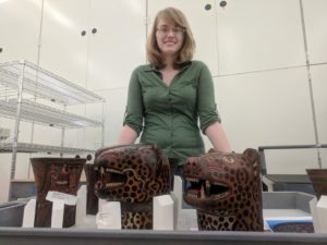
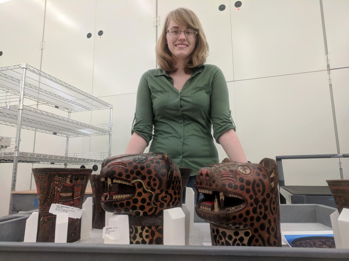
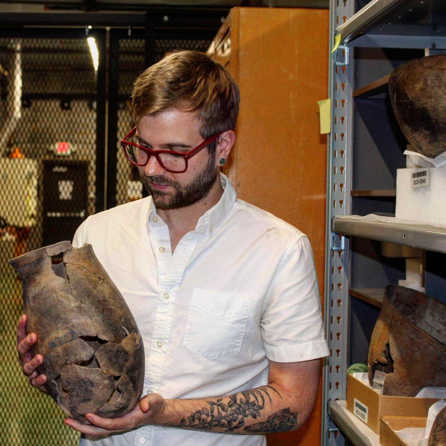
Lead researcher Allison Curley with qeros from the collection of the Smithsonian National Museum of the American Indian. Alyson Thibodeau

_________________________________

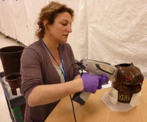
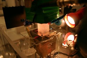
Emily Kaplan using portable X-Ray Fluorescence to detect elements in pigments on a qero at the Smithsonian National Museum of the American Indian. NMAI staff

_________________________________

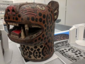
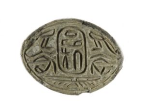
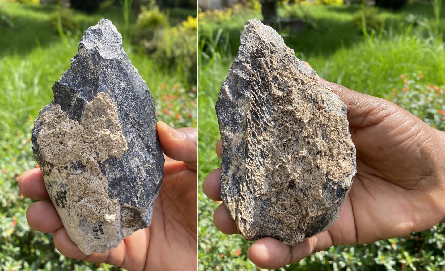
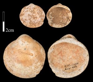
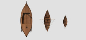
A qero from the collection of the Smithsonian National Museum of the American Indian. Alyson Thibodeau

_________________________________

Article Source: Dickinson College news release

_________________________________

Advertisement

Big brains and dexterous hands

UNIVERSITY OF ZURICH—People are very skilled with their hands, but take a very long time to learn various dexterous abilities. It takes babies generally around five months before they can purposely grip an object. Learning more complicated skills such as eating with fork and knife or tying one’s shoelaces can take another five to six years. By that age, many other primate species already have offspring of their own. Why do we take so much longer than our closest relatives to learn fine motor skills?

Brain development in primates follows fixed patterns

Sandra Heldstab, an evolutionary biologist in the Department of Anthropology at the University of Zurich, and her colleagues Karin Isler, Caroline Schuppli and Carel van Schaik observed 36 different primate species over a period of more than seven years to try to answer this question. She studied 128 young animals in 13 European zoos from birth until the age at which they had reached adult-level dexterity. What surprised her was that all species learned their respective manual skills in exactly the same order. “Our results show that the neural development follows extremely rigid patterns – even in primate species that differ greatly in other respects,” says Heldstab.

Large brain needed for dexterity

The researchers found, however, big differences in the specific fine motor skills of adults from different primate species. Large-brained species such as macaques, gorillas or chimpanzees can solve much more complex tasks using their hands than primates with small brains such as lemurs or marmosets. “It is no coincidence that we humans are so good at using our hands and using tools, our large brains made it possible. A big brain equals great dexterity,” says Heldstab.

Humans develop fine motor skills later than primates

Dexterity comes at a cost, however: In species with large brains like humans, it takes a long time for infants to learn even the simplest hand and finger movements. “It’s not just because we are learning more complex skills than lemurs or callitrichids, for example. It’s mainly because we do not begin learning these skills until much later,” says Heldstab. The researchers think that the reason for this may be that the larger brains of humans are less well developed at birth.

Essential to have enough time to learn

In addition, learning takes time and is inefficient, and it is the parents who pay for this until their offspring are independent. “Our study shows once again that in the course of evolution, only mammals that live a long time and have enough time to learn were able to develop a large brain and complex fine motor skills including the ability to use tools. This makes it clear why so few species could follow our path and why humans could become the most technologically accomplished organism on this planet,” concludes Sandra Heldstab.

_________________________________

Great apes like these bonobos have big brains like humans and can therefore learn very skillful dexterity. Image: Sandra Heldstab, Zoologisch-Botanischer Garten Wilhelma, Stuttgart

_________________________________

Article Source: UNIVERSITY OF ZURICH news release

_________________________________

Advertisement

Researchers find evidence of smallpox in the viking age

UNIVERSITY OF COPENHAGEN THE FACULTY OF HEALTH AND MEDICAL SCIENCES—The fatal disease smallpox is older and more widespread than scientists so far have proved. A new study by an international team of researchers from the University of Copenhagen and the University of Cambridge shows that the Vikings also suffered from smallpox.

Through the ages, the highly infectious disease smallpox has killed hundreds of millions of people. But it is unclear exactly when the disease emerged. There has been found evidence of smallpox from individuals from the 17th century while written records suggest the disease is much older.

Now a new study shows that the disease dates 1,000 years further back in time than previously shown. Researchers from the University of Copenhagen (UCPH) and the University of Cambridge have found proof that smallpox also existed in the Viking Age. The new results have been published in the scientific journal Science.

“We have found the oldest evidence of smallpox. Moreover, it seems to have been surprisingly common as early as in the Viking Age,” says Associate Professor Martin Sikora, Globe Institute, UCPH, and the University of Cambridge. He continues:

“Smallpox is the infection in the world that has killed most people. For that reason alone, it is very important and interesting to know how the disease developed. It gives us a unique opportunity to understand the viruses’ evolution: How did it change and become the pathogen that we know of today.”

Widespread in Northern Europe

The researchers have studied and analyzed the DNA of 13 individuals from Northern Europe infected with smallpox. The samples are 1,000 years older than the previous oldest sample known to have been infected based on ancient DNA, and they thus push the timeline for smallpox further back in time.

The study also shows the disease has been more widespread than previously assumed. The general idea used to be that smallpox was not endemic to Northern Europe during that time period.

“We show that not only was it endemic in Europe, but it was actually quite widespread in Northern Europe already at the year 600. That means that the disease was almost certainly far more established at a much earlier age than previously thought,” says Professor Eske Willerslev, Globe Institute, UCPH.

The researchers have also discovered that the viruses circulating during the Viking Age were distinct from their modern counterparts, and not directly ancestral to the viruses that caused the last big outbreak of smallpox in the 20th century.

“They share a common ancestor, but they also have unique features that differentiate them from the ones circulating later on in history. It turns out that the viruses we have found were some of these very, very early and different versions of the devastating pathogens known from the 20th century. It is the first time we can trace these early smallpox viruses and compare their genomes and mutations and see how the disease evolved over time,” says Eske Willerslev.

Catalogue of Mutations

Even though the disease has been eradicated today, it is still very useful to know how it developed and mutated through the ages.

Smallpox is a so-called poxvirus, a large family of viruses with many different types infecting a diverse set of host species. One such example is monkeypox, which typically infects monkeys but has also been known to cause a disease similar to smallpox in humans. It is therefore useful to known how other types of poxviruses mutate and survive.

“When we know how the disease mutated through time, it gives us an opportunity to put together a catalogue of how these pathogens might mutate in the future: What mutations and combinations make such a pathogen viable and successful? If they had those mutations in the past, they can most likely get them again.”

“It is one of a few examples where ancient genetic research has direct implications for present-day and future health,” says Martin Sikora.

______________________________

A Viking grave. Efraim Stochter, Pixabay

______________________________

Article Source: UNIVERSITY OF COPENHAGEN THE FACULTY OF HEALTH AND MEDICAL SCIENCES news release

______________________________

Advertisement

Foxes have been eating humans’ leftovers for 42,000 years

PLOS—The diets of ancient foxes were influenced by humans, and these small carnivores might be tracers of human activity over time, according to a study* published July 22, 2020 in the open-access journal PLOS ONE by Chris Baumann of the University of Tübingen, Germany and colleagues.

Foxes love leftovers. In the wild, foxes regularly feed on scraps left behind by larger predators like bears and wolves, but the closer foxes live to human civilization, the more of their diet is made up of foods that humans leave behind. In this study, Baumann and colleagues hypothesized that if this commensal relationship goes back to ancient times, then foxes might be useful indicators of human impact in the past.

The authors compared ratios of Carbon and Nitrogen isotopes between the remains of various herbivores, large carnivores, and red and Arctic foxes from several archaeological sites in southwest Germany dating to the Middle and Upper Palaeolithic. At sites older than 42,000 years, when Neanderthals sparsely occupied the region, fox diets were similar to their local large carnivores. But in the younger sites, as Homo sapiens became common in the area, foxes developed a more unique diet consisting largely of reindeer, which are too big for foxes to hunt but which are known to have been important game for ancient humans of the time.

These results suggest that during the Upper Palaeolithic, these foxes made a shift from feeding on scraps left by local large predators to eating food left behind by humans. This indicates that foxes’ reliance on human food goes back a good 42,000 years. The authors propose that, with further studies investigating this fox-human relationship, ancient fox diets may be useful indicators of human impact on ecosystems over time.

The authors add: “Dietary reconstructions of Ice Age foxes have shown that early modern humans had an influence on the local ecosystem as early as 40,000 years ago. The more humans populated a particular region, the more the foxes adapted to them.”

________________________________

Summary figure for the commensal fox hypothesis. The blue area marks the impact of humans on dietary resources. For low δ15N foxes, humans had no influence, while for intermediate δ15N foxes they had a very strong influence (restricted diet). High δ15N foxes may be influenced (e.g. by scavenging at kill sites) or may be of natural origin (e.g. by scavenging from megafauna that died naturally). Baumann et al, 2020 (PLOS ONE, CC BY 4.0)

________________________________

*Baumann C, Bocherens H, Drucker DG, Conard NJ (2020) Fox dietary ecology as a tracer of human impact on Pleistocene ecosystems. PLoS ONE 15(7): e0235692. https://doi.org/10.1371/journal.pone.0235692

________________________________

Advertisement

Humans in America as much as 30,000 years ago, suggest scientists

University of Cambridge and University of Copenhagen—A cave in a remote part of Mexico was visited by humans around 30,000 years ago – 15,000 years earlier than people were previously thought to have reached the Americas.

Painstaking excavations of Chiquihuite Cave, located in a mountainous area in northern Mexico controlled by drug cartels, uncovered 1,900 stone tools from a small section of the high-altitude cave.

Archaeological analysis of the tools and DNA analysis of the sediment in the cave uncovered a new story of the colonization of the Americas which now traces evidence of the first Americans back to 25,000-30,000 years ago.

The results, which have been published in Nature today (July 22 2020), challenge the commonly held theory that the Clovis people were the first human inhabitants of the Americas 15,000 years ago.

DNA scientist Professor Eske Willerslev, of St John’s College, University of Cambridge, and director of The Lundbeck Foundation GeoGenetics Centre, University of Copenhagen, led the study with archaeologist Dr Ciprian Ardelean, of the University of Zacatecas in Mexico. 

Professor Willerslev said: “For decades people have passionately debated when the first humans entered the Americas. Chiquihuite Cave will create a lot more debate as it is the first site that dates the arrival of people to the continent to around 30,000 years ago – 15,000 years earlier than previously thought. These early visitors didn’t occupy the cave continuously, we think people spent part of the year there using it as a winter or summer shelter, or as a base to hunt during migration. This could be the Americas oldest ever hotel.”

The 10-year long research project raises more questions about the early humans who lived in the Americas than it solves.

Dr Ardelean said: “We don’t know who they were, where they came from or where they went. They are a complete enigma. We falsely assume that the indigenous populations in the Americas today are direct descendants from the earliest Americans, but now we do not think that is the case.

“By the time the famous Clovis population entered America, the very early Americans had disappeared thousands of years before. There could have been many failed colonizations that were lost in time and did not leave genetic traces in the population today.”

Chiquihuite Cave is a high-altitude site, 2750 meters above sea level. Nearly 2000 stone tools and small tool fragments, known as flakes, were discovered. DNA analysis of the plant and animal remains from the sediment packed around the tools in the cave dates the tools and the human occupation of the site to 25,000-30,000 years ago. Human DNA was not found which adds weight to the theory that the early people didn’t stay for long in the cave.

Dr Mikkel Winther Pedersen, a geneticist from the University of Copenhagen and one of the first authors of the paper, said: “We identified DNA from a wide range of animals including black bears, rodents, bats, voles and even kangaroo rats. We think these early people would probably have come back for a few months a year to exploit reoccurring natural resources available to them and then move on. Probably when herds of large mammals would have been in the area and who had little experience with humans so they would have been easy prey. The location of Chiquihuite Cave definitely rewrites what has conventionally been taught in history and archaeology and shows that we need to rethink where we look for sites of the earliest people in Americas.”

The Stone Tools

As far back as 30,000 years ago, humans had already developed techniques for producing tools. In this Mexican cave, researchers found 1,900 stone tools.

The unique feature of the Chiquihuite Cave is the “floor”, which consists of six layers of detritus and dust – all in all, a ten-foot column of ancient remains – which is so compressed and stable that by using various advanced measuring methods, it has been possible to date the layers one by one, from top to bottom.

Each layer has contained deposits of stone tools such as knives, scrapers and arrowheads, which the researchers have also been able to date.

“The cave finds are extremely interesting. These archaeological finds are so far the oldest in America. And the excavated stone tools are of a type unique to America,” Professor at Universidad Autónoma de Zacatecas, Mexico, Ciprian F. Ardelean, states.

Ice Cap Across North America

Until now, science has assumed that the earliest immigration to America took place approx. 15,000 years ago. At the time, a narrow opening in the ice along the northern Pacific coastline was created, which made it possible to walk from Siberia onto the American continent.

At the time, there were no other access routes to the continent, because North America was covered by a thick ice cap, which only later – approx. 13,000 years ago – melted enough to enable passage.

30,000 years ago, when the first stone tools were left in the Chiquihuite Cave, the massive ice cap had not yet covered all of North America, which means that it would have been possible to walk from Siberia and down through the American continent, Eske Willerslev explains.


The Chiquihuite Cave site is very difficult to reach and would have been a good vantage point for the early people to defend themselves from as they could look out for miles over the valley without being seen. It is in an area of Mexico that is now controlled by drugs cartels. The academics were escorted by armed police to the base of the mountain before they made their way up to the cave on foot.

Dr Pedersen said: “It was an unforgettable experience. It is a very unsafe place to travel so we were accompanied by Mexican police officers in armoured cars to the foot of the mountain. We left before sunrise to climb up to the cave so that we weren’t spotted.”

The visiting DNA scientists slept in the cave during their research visit and over the past 10 years Dr Ardelean has spent a number of months living in the cave to carry out the painstaking excavations.

Dr Ardelean added: “The peopling of the Americas is the last holy grail in modern archaeology. Unconventional sites need to be taken seriously and we need to go out and intentionally look for them. This site doesn’t solve anything, it just shows that these early sites exist. We are dealing with a handful of humans from thousands of years ago so we cannot expect the signals to be very clear. We have literally dug deeper than anyone has done in the past.”

The earliest human DNA from the Americas currently remains at 12,400 years ago, Dr Ardelean explained: “We have shown the previously long held date of human presence is not the oldest date for populating the Americas, it is the explosion date of populating the Americas.”

Professor Willerslev concluded: “I will never forget being part of this research, it was an unbelievable experience. The implications of these findings are as important, if not more important, than the finding itself. This is only the start of the next chapter in the hotly debated early peopling of the Americas.”

________________________________

View of the Sierra El Astillero mountains where the Chiquihuite cave was found in 2012. Devlin A. Gandy

________________________________

Team members entering the Chiquihuite cave. Devlin A. Gandy

________________________________

Assistant professor Mikkel Winther Pedersen from the University of Copenhagen sampling the cave sediments for DNA. Devlin A. Gandy

________________________________

Assistant professor Mikkel Winther Pedersen with team members carefully sampling the different cultural layers in the cave. Mads Thomsen

________________________________

Assistant professor Mikkel Winther Pedersen with team members carefully sampling the different cultural layers in the cave. Devlin A. Gandy

________________________________

Stone tool found below the Last Glacial Maximum (LGM) layer, within Stratigraphic Component C, at Chiquihuite Cave. Ciprian Ardelean.

________________________________

Article Source: Edited and adapted from news releases of the University of Copenhagen and St. John’s College, University of Cambridge

________________________________

Advertisement

Neanderthals of Western Mediterranean did not become extinct because of changes in climate

UNIVERSITÀ DI BOLOGNA—Homo Neanderthalensis did not become extinct because of changes in climate. At least, this did not happen to the several Neanderthal groups that lived in the western Mediterranean 42,000 years ago. A research group of the University of Bologna came to this conclusion after a detailed paleoclimatic reconstruction of the last ice age through the analysis of stalagmites sampled from some caves in Apulia, Italy.

The researchers focused on the Murge karst plateau in Apulia, where Neanderthals and Homo sapiens coexisted for at least 3,000 years, from approximately 45,000 to 42,000 years ago. This study was published in Nature Ecology & Evolution. Data extracted from the stalagmites showed that climate changes that happened during that time span were not particularly significant. “Our study shows that this area of Apulia appears as a ‘climate niche’ during the transition from Neanderthals to Homo sapiens” explains Andrea Columbu, researcher and first author of this study. “It doesn’t seem possible that significant climate changes happened during that period, at least not impactful enough to cause the extinction of Neanderthals in Apulia and, by the same token, in similar areas of the Mediterranean”.

THE CLIMATE CHANGE HYPOTHESIS

The hypothesis that a changing climate was a factor in Neanderthals extinction (that happened in Europe nearly 42,000 years ago) found considerable support among the scientific community. According to this theory, during the last ice age, sharp and rapid changes in climate were a decisive factor in Neanderthals’ extinction because of the increasingly cold and dry weather.

We can find confirmation of these sharp changes in the analysis of ice cores from Greenland and from other paleoclimatic archives of continental Europe. However, when it comes to some Mediterranean areas where Neanderthals had lived since 100,000 years ago, the data tell a different story. The Western Mediterranean is rich in prehistoric findings and, until now, no one ever carried out a paleoclimatic reconstruction of these Neanderthal-occupied areas.

THE IMPORTANCE OF STALAGMITES

Where can we find answers about the past climate of the Western Mediterranean? The research group of the University of Bologna turned to the Murge plateau in Apulia. “Apulia is key to our understanding of anthropological movements: we know that both Neanderthals and Homo sapiens lived there approximately 45,000 years ago”, says Andrea Columbu. “Very few other areas in the world saw both species co-existing in a relatively small space. This makes the Murge plateau the perfect place to study the climate and the bio-cultural grounds of the transition from Neanderthal to Sapiens”.

How is it possible to provide a climate reconstruction of such a remote period? Stalagmites have the answer. These rock formations rise from the floor of karst caves thanks to ceiling water drippings. “Stalagmites are excellent paleoclimatic and paleoenvironmental archives”, explains Jo De Waele, research coordinator and professor at the University of Bologna. “Since stalagmites form through rainwater dripping, they provide unquestionable evidence of the presence or absence of rain. Moreover, they are made of calcite, which contains carbon and oxygen isotopes. The latter provide precise information about how the soil was and how much it rained during the formation period of stalagmites. We can then cross these pieces of information with radiometric dating, that provide an extremely precise reconstruction of the phases of stalagmites’ formation”.

A (RELATIVELY) STABLE CLIMATE

The pace at which stalagmites formed is the first significant result of this study. Researchers found out that Apulian stalagmites showed a consistent pace of dripping in the last and previous ice ages. This means that no abrupt change in climate happened during the millennia under investigation. A draught would have been visible in the stalagmites.

Among all the stalagmites that were analyzed, one was particularly relevant. Researchers sampled this 50-cm long stalagmite in the Pozzo Cucù cave, in the Castellana Grotte area (Bari) and they carried out 27 high-precision datings and 2,700 analyses of carbon and oxygen stable isotopes. According to dating, this stalagmite formed between 106,000 and 27,000 years ago. This stalagmite represents the longest timeline of the last ice age in the western Mediterranean and in Europe. Moreover, this stalagmite did not show any trace of abrupt changes in climate that might have caused Neanderthals’ extinction.

“The analyses we carried out show little variation in rainfall between 50,000 and 27,000 years ago, the extent of this variation is not enough to cause alterations in the flora inhabiting the environment above the cave”, says Jo De Waele. “Carbon isotopes show that the bio-productivity of the soil remained all in all consistent during this period that includes the 3,000 years-long coexistence between Sapiens and Neanderthals. This means that significant changes in flora and thus in climate did not happen”.

THE TECHNOLOGY HYPOTHESIS

The results seem to show that the dramatic changes in the climate of the last ice age had a different impact on the Mediterranean area than in continental Europe and Greenland. This may rule out the hypothesis that climate changes are responsible for Neanderthals dying out.

How do we explain their extinction after a few millennia of coexistence with Homo sapiens? Stefano Benazzi, a palaeontologist at the University of Bologna and one of the authors of the paper, provides an answer to this question. “The results we obtained corroborate the hypothesis, put forward by many scholars, that the extinction of Neanderthals had to do with technology”, says Benazzi. “According to this hypothesis, the Homo sapiens hunted using a technology that was far more advanced than Neanderthals’, and this represented a primary reason to Sapiens’ supremacy over Neanderthals, that eventually became extinct after 3,000 years of co-existence”.

_________________________________

Researchers sampled this 50-cm long stalagmite in the Pozzo Cucù cave, in the Castellana Grotte area (Bari) and they carried out 27 high-precision datings and 2,700 analyses of carbon and oxygen stable isotopes. O. Lacarbonara

_________________________________

THE AUTHORS OF THE STUDY

The study was published in Nature Ecology & Evolution with the title “Speleothem record attests to stable environmental conditions during Neanderthal- modern human turnover in southern Italy”. Representing the University of Bologna, we have Andrea Columbu, Veronica Chiarini and Jo De Waele from the Department of Biological, Geological and Environmental Sciences, and Stefano Benazzi from the Department of Cultural Heritage.

Other scholars also participated in the study: from the University of Innsbruck (Austria) where the isotopic analyses were carried out, from Melbourne University (Australia) and Xi’an Jiaotong University (China), that carried out the radiometric dating.

Grotte di Castellana, the Apulian Speleology Association and, for the major part, local speleology groups provided funding for this study.

Article Source: UNIVERSITÀ DI BOLOGNA news release

_________________________________

Advertisement

Breakthrough in studying ancient DNA from Doggerland that separates the UK from Europe

UNIVERSITY OF WARWICK—Thousands of years ago the UK was physically joined to the rest of Europe through an area known as Doggerland. However, a marine inundation took place during the mid-holocene, separating the British landmass from the rest of Europe, which is now covered by the North Sea.

Scientists from the School of Life Sciences at the University of Warwick have studied sedimentary ancient DNA (sedaDNA) from sediment deposits in the southern North Sea, an area which has not previously been linked to a tsunami that occurred 8150 years ago.

The paper, led by the University of Bradford and involving Universities of Warwick, Wales St. Trinity David, St. Andrews, Cork, Aberystwyth, Tartu as well as the Smithsonian and Natural History Museum, ‘Multi-Proxy Characterisation of the Storegga Tsunami and Its Impact on the Early Holocene Landscapes of the Southern North Sea’, published in the Journal Geosciences, sees Life Scientists from the University of Warwick work specifically on the sedimentary ancient DNA from Doggerland.

A number of innovative breakthroughs were achieved by the University of Warwick scientists in terms of analysing the sedaDNA. One of these was the concept of biogenomic mass, where for the first time they were able to see the how the biomass changes with events, evidence of this presented in the paper refers to the large woody mass of trees from the tsunami found in the DNA of the ancient sediment.

New ways of authenticating the sedaDNA were also developed, as current methods of authentication do not apply to sedaDNA which has been damaged whilst under the sea for thousands of years because there is too little information for each individual species. Researchers therefore came up with a new way, metagenomic assessment methodology, whereby the characteristic damage found at the ends of ancient DNA molecules is collectively analyzed across all species rather than one.

Alongside this a key part of analyzing the sedaDNA is to determine whether or not it was deposited in situ or has moved over time. This led researchers to develop statistical methods to establish which scenario was appropriate, using stratigraphic integrity they were able to determine that the sedaDNA in the sediment deposits had not moved a massive amount since deposition by assessing the biomolecules vertical movement in the core column of the sedaDNA.

Identifying which organisms the ancient fragmented molecules of DNA came from is also challenging because often there is nothing to directly compare. In a fourth innovation the researchers refined algorithms to define these regions of “dark phylogenetic space” from where organisms must have originated overcome this issue.

Professor Robin Allaby from the School of Life Sciences at the University of Warwick comments: “This study represents an exciting milestone for sedimentary ancient DNA studies establishing a number of breakthrough methods to reconstruct an 8,150 year old environmental catastrophe in the lands that existed before the North Sea flooded them away into history.”

Professor Vince Gaffney from the School of Archaeological and Forensic Sciences at the University of Bradford said: “Exploring Doggerland, the lost landscape underneath the North Sea, is one of the last great archaeological challenges in Europe. This work demonstrates that an interdisciplinary team of archaeologists and scientists can bring this landscape back to life and even throw new light on one of prehistory’s great natural disasters, the Storegga Tsunami.

“The events leading up to the Storegga tsunami have many similarities to those of today. Climate is changing and this impacts on many aspects of society, especially in coastal locations.”

_________________________________

Mp showing location of ancient Doggerland. Public Domain, Wikimedia Commons

_________________________________

A map of the UK and the area studied is starred. University of Bradford

_________________________________

The sediment of which the sedaDNA was studied. Dr Martin Bates, UWTSD

_________________________________

Article Source: UNIVERSITY OF WARWICK news release

Paper available to view at: https://www.mdpi.com/2076-3263/10/7/270

_________________________________

Advertisement

Rewriting history: New evidence challenges Euro-centric narrative of early colonization

WASHINGTON UNIVERSITY IN ST. LOUIS—In American history, we learn that the arrival of Spanish explorers led by Hernando de Soto in the 1500s was a watershed moment resulting in the collapse of Indigenous tribes and traditions across the southeastern United States.

While these expeditions unquestionably resulted in the deaths of countless Indigenous people and the relocation of remaining tribes, new research from Washington University in St. Louis provides evidence that Indigenous people in Oconee Valley — present-day central Georgia — continued to live and actively resist European influence for nearly 150 years.

The findings, published July 15 in American Antiquity, speak to the resistance and resilience of Indigenous people in the face of European insurgence, said Jacob Lulewicz, a lecturer in archaeology in Arts & Sciences and lead author.

“The case study presented in our paper reframes the historical contexts of early colonial encounters in the Oconee Valley by way of highlighting the longevity and endurance of Indigenous Mississippian traditions and rewriting narratives of interactions between Spanish colonizers and Native Americans,” Lulewicz said.

It also draws into question the motives behind early explanations and interpretations that Euro-Americans proposed about Indigenous earthen mounds — platforms built out of soil, clay and stone that were used for important ceremonies and rituals.

‘Myths were purposively racist’

“By the mid-1700s, less than 100 years after the abandonment of the Dyar mound [now submerged under Lake Oconee], explanations for the non-Indigenous origins of earthen mounds were being espoused. As less than 100 years would have passed between the Indigenous use of mounds and these explanations, it could be argued that the motives for these myths were purposively racist, denying what would have been a recent collective memory of Indigenous use in favor of explanations that stole, and disenfranchised, these histories from contemporary Indigenous peoples,” Lulewicz said.

The Dyar mound was excavated by University of Georgia archaeologists in the 1970s to make way for a dam. Lulewicz and co-authors — Victor D. Thompson, professor of archaeology and director of the Laboratory of Archaeology at the University of Georgia; James Wettstaed, archaeologist at Chattahoochee-Oconee National Forests; and Mark Williams, director emeritus of the Laboratory of Archaeology at the University of Georgia — received funding from the USDA Forest Service to re-date the platform mound, which contained classic markers of Indigenous rituals and ceremonies.

Using advanced radiocarbon dating techniques and complex statistical models, modern-day archaeologists are able to effectively construct high-resolution, high-precision chronologies. In many cases, they can determine, within a 10- to 20-year range, dates of things that happened as far back as 1,000 years ago.

“Radiocarbon dating is really important, not just for getting a date to see when things happened, but for understanding the tempo of how things changed throughout time and really understanding the complex histories of people over hundreds of years,” Lulewicz said. “In archaeology, it’s really easy to group things in long periods of time, but it would be false to say that nothing changed over those 500 years.”

Their research yielded 20 new dates from up and down the mound, which provided a refined perspective on the effects that early Indigenous-colonizer encounters did, and did not, have on the Indigenous people and their traditions.

Missing from the mound was any sign of European artifacts, which is one of the reasons why archaeologists originally believed sites in the region were abruptly abandoned just after their first encounters with Spanish colonizers. “Not only did the ancestors of Muscogee (Creek) people continue their traditions atop the Dyar mound for nearly 150 years after these encounters, but they also actively rejected European things,” Lulewicz said.

According to Lulewicz, the Dyar mound does not represent an isolated hold-over after contact with European colonizers. There are several examples of platform mounds that were used beyond the 16th century, including the Fatherland site associated with the Natchez in Louisiana, Cofitachequi in South Carolina and a range of towns throughout the Lower Mississippi Valley.

“However, the mound at Dyar represents one of the only confirmed examples, via absolute dating, of continued Mississippian traditions related to mound-use and construction to date.”

Today, members of the Muscogee (Creek) Nation, descendants of the Mississippians who built platform mounds like the one at Dyar, live in Oklahoma. “We have a great, collaborative relationship with archaeologists of the Muscogee (Creek) Nation Historic and Cultural Preservation Department, so we sent them the paper to review. It was really well received. They saw, reflected in that paper, a lot of the traditions they still practice in Oklahoma and were generous enough to contribute commentary that bolstered the results presented in the paper,” he said.

“This is where the archaeology that we write becomes so important in the present. … Without this type of work, we are contributing to the disenfranchisement of Indigenous peoples from their history.”

“Of course, they already knew many of the things we ‘discovered,’ but it was still meaningful to be able to reaffirm their ancestral link to the land.”

In the end, Lulewicz said this is the most important part of the paper. “We are writing about real human lives — Indigenous lives that we have historically treated very poorly and who continue to be treated poorly today in some cases. With the use of advanced radiocarbon dating and the development of really high resolution chronologies, we are able to more effectively reinject lives into narratives of the past.”

__________________________________

Jacob Lulewicz, lecturer in archaeology at Washington Universiity in St. Louis, studies southeastern/midwestern ethnohistory and archaeology including Indigenous-colonizer dynamics; social networks and sociopolitics. WUSTL

__________________________________

Article Source: WASHINGTON UNIVERSITY IN ST. LOUIS news release

__________________________________

Advertisement

Fecal Biomarkers Confirm That Ancient Humans Left Behind Fossilized Poop in Oregon’s Paisley Caves

Science Advances—Fecal biomarkers confirm that fossilized feces discovered in Oregon’s Paisley Caves originated from humans, with some samples dating back more than 12,000 years, according to a new study. While previous mitochondrial DNA (mtDNA) analyses suggested the specimens came from some of the earliest humans to occupy the Americas, Lisa-Marie Shillito and colleagues provide greater certainty about the ancient turds’ identities by analyzing lipid biomarkers, which are less sensitive to contamination, although they provide less detailed information. The researchers conclude that both methods – analyzing mitochondrial DNA and lipid biomarkers – may be used in tandem as scientists search prehistoric poo for clues about when the first people arrived in the Americas, how they got here, and how they adapted to its varying terrain. Dung samples such as those from Paisley Caves can help fill in the blanks about the lives of ancient humans when skeletal remains are scarce. Earlier studies of some of the dung samples were called into question since some of the mtDNA recovered from them could have leached into the samples from later occupants of the cave who defecated there, or it could have been derived from other species that used the cave. To explore whether lipid biomarkers in the fossilized feces could help solve the mystery of who deposited them in the cave, Shllito et al. sampled 21 specimens that were previously identified through mtDNA analysis to determine their sterol and bile acid content. They next compared lipids derived from one dung sample with lipids from the surrounding sediment, finding distinctly different distributions that suggest minimal leaching occurred between the dung and its environment. Ultimately, the researchers found that the identities of 13 of the fossilized feces agreed with previously reported classifications based on mitochondrial DNA, the majority of which came from humans. The oldest dated back to about 12,200 years ago, demonstrating that humans have occupied the Paisley Caves since at least that time. The findings support the theory that humans first settled in America before the arrival of the ancient Clovis people, who were long thought to be the ancestors of the indigenous peoples of the Americas.

_______________________________

View of the Paisley Caves outcrop from the base camp.Dr. John Blong

_______________________________

Outside the Paisley Caves entrance. Dr. John Blong

_______________________________

The excavation team discussing the sediments. Dr. John Blong

_______________________________

Dr. Lisa-Marie Shillito collecting. Dr. John Blong

_______________________________

Dr. Helen Whelton working on samples in the lab. Dr. John Blong

_______________________________

Article Source A Science Advances news release. Science Advances is published by AAAS, the nonprofit science society.

_______________________________

Advertisement

Hyksos, 15th Dynasty rulers of Ancient Egypt, were an internal takeover

PLOS—The Hyksos, who ruled during the 15th Dynasty of ancient Egypt, were not foreign invaders, but a group who rose to power from within, according to a study* published July 8, 2020 in the open-access journal PLOS ONE by Chris Stantis of Bournemouth University, UK and colleagues.

The Hyksos were a foreign dynasty that ruled parts of Egypt between approximately 1638-1530 BCE, the first instance of Egypt being ruled by individuals of a foreign origin. The common story is that the Hyksos were invaders from a far-off land, but this idea has been drawn into question. Archaeological evidence does link Hyksos culture with an origin in the Near East, but exactly how they rose to power is unclear.

In this study, Stantis and colleagues collected enamel samples from the teeth of 75 humans buried in the ancient Hyksos capital city of Tell el-Dab’a in the northeast Nile Delta. Comparing ratios of strontium isotopes in the teeth to environmental isotope signatures from Egypt and elsewhere, they assessed the geographic origins of the individuals who lived in the city. They found that a large percentage of the populace were non-locals who immigrated from a wide variety of other places. This pattern was true both before and during the Hyksos dynasty.

This pattern does not match the story of a sudden invasion from a single far-off land, but of a multi-cultural region where one internal group – the Hyksos – eventually rose to power after living there for generations. This is the first study to use archaeological chemistry to address the origins of the Hyksos rulers, but the authors note that more investigations and broader chemical techniques will be needed to identify the specific ancestries of the Hyksos and other non-local residents of Egypt.

Stantis adds: “Archaeological chemistry, specifically isotopic analysis, shows us first-generation migration during a time of major cultural transformations in ancient Egypt. Rather than the old scholastic theories of invasion, we see more people, especially women, migrating to Egypt before Hyksos rule, suggesting economic and cultural changes leading to foreign rule rather than violence.”

__________________________________

Seal amulet with the name of the Hyksos pharoah Apophis. The Metropolitan Museum of Art (CC0)

__________________________________

Hyksos sphinxes

__________________________________

Article Source: PLOS ONE news release

*Stantis C, Kharobi A, Maaranen N, Nowell GM, Bietak M, Prell S, et al. (2020) Who were the Hyksos? Challenging traditional narratives using strontium isotope (87Sr/86Sr) analysis of human remains from ancient Egypt. PLoS ONE 15(7): e0235414. https://doi.org/10.1371/journal.pone.0235414

__________________________________

Advertisement

29,000 years of Aboriginal history

FLINDERS UNIVERSITY—The known timeline of the Aboriginal occupation of South Australia’s Riverland region has been vastly extended by new research led by Flinders University in collaboration with the River Murray and Mallee Aboriginal Corporation (RMMAC).

Radiocarbon dating of shell middens – remnants of meals eaten long ago – capture a record of Aboriginal occupation that extends to around 29,000 years, confirming the location as one of the oldest sites along the 2500km river to become the oldest River Murray Indigenous site in South Australia.

In the first comprehensive survey of the region, one of the oldest Indigenous sites along Australia’s longest river system has been discovered. The results, published in Australian Archaeology, used radiocarbon dating methods to analyze river mussel shells from a midden site overlooking the Pike River floodplain downstream of Renmark.

“These results include the first pre-Last Glacial Maximum ages returned on the River Murray in South Australia and extend the known Aboriginal occupation of the Riverland by approximately 22,000 years,” says Flinders University archaeologist and PhD candidate Craig Westell.

More than 30 additional radiocarbon dates were collected in the region, spanning the period from 15,000 years ago to the recent present. Together, the results relate Aboriginal people to an ever-changing river landscape, and provide deeper insights into how they responded to these challenges.

The period represented by the radiocarbon results brackets the Last Glacial Maximum (commonly known as the last Ice Age) when climatic conditions were colder and drier and when the arid zone extended over much of the Murray-Darling Basin. The river and lake systems of the basin were under stress during this time.

In the Riverland, dunes were advancing into the Murray floodplains, river flows were unpredictable, and salt was accumulating in the valley.

The ecological impacts witnessed during one of the worst droughts on record, the so-called Millennium Drought (from late 1996 extending to mid-2010), provides an idea of the challenges Aboriginal people may have faced along the river during the Last Glacial Maximum, and other periods of climate stress, researchers conclude.

“These studies show how our ancestors have lived over many thousands of years in the Riverland region and how they managed to survive during times of hardship and plenty,” says RMMAC spokesperson Fiona Giles.

“This new research, published in Australian Archaeology, fills in a significant geographic gap in our understanding of the Aboriginal occupation chronologies for the Murray-Darling Basin,” adds co-author Associate Professor Amy Roberts.

The dating, which was undertaken at the Australian Nuclear Science and Technology Organization (ANSTO) and Waikato University, forms part of a much larger and ongoing research program led by Associate Professor Amy Roberts which is undertaking a broad-ranging investigation of past and contemporary Aboriginal connections to the Riverland region.

The paper, ‘Initial results and observations on a radiocarbon dating program in the Riverland region of South Australia’ (2020) by C Westell, A Roberts, M Morrison, G Jacobsen and the River Murray and Mallee Aboriginal Corporation has been published in Australian Archaeology DOI: 10.1080/03122417.2020.1787928

The Last Glacial Maximum is the most significant climatic event to face modern humans since their arrival in Australia some 40,000-50,000 years ago. Recent studies have demonstrated that the LGM in Australia was a period of significant cooling and increased aridity beginning 30 ka and peaking between 23 and 18 ka.

______________________________

Midden shell exposed on the Pike cliff line on the River Murray. Flinders University

______________________________

Location map shows the areas studied by archaeologists and the River Murray and Mallee Aboriginal community in South Australia. Flinders University

______________________________

Article Source: FLINDERS UNIVERSITY news release

______________________________

Advertisement

Advanced Acheulean tool technology

PROCEEDINGS OF THE NATIONAL ACADEMY OF SCIENCES—A 1.4-million-year-old handaxe made from hippopotamus bone expands the known technological repertoire of early human ancestors, according to a study*. During the Pleistocene, Homo species developed handaxes from stone and, occasionally, bone, a tool production style known as the Acheulean. Gen Suwa and colleagues report a rare handaxe made from bone in the Konso Formation, showing that the advanced flaking techniques used on lithic materials were also practiced on bone by early Homo species living in southern Ethiopia. The 13-cm-long bone was recovered from strata dating to 1.4 million years ago. The authors characterized the bone, noting that it retained the surface of an original hippopotamus femur on the dorsal side and exhibited extensive flake scars. Analysis of the flake scars showed that the scars are continuous and that those near the handaxe’s tip appear in an alternate pattern, suggesting deliberate shaping of the bone. The authors also analyzed wear on the handaxe, finding macroscopic rounding near the tip and on both faces, suggesting cutting and sawing activities. Microscopic analysis of the handaxe revealed areas of polish and striation patterns similar to stone tools used for butchery. Given the small number of bone tools unearthed and a dearth of knowledge about bone polish patterns, the nature of the materials on which the rare bone handaxe was used remains unclear, according to the authors.

________________________________

Both sides of the 1.4 million-year-old bone handaxe Berhane Asfaw

________________________________

The bone handaxe (micro-ct based render) shown placed in a hippopotamus femur. Gen Suwa

________________________________

Article Source: PNAS news release

*”A 1.4-million-year-old bone handaxe from Konso, Ethiopia, shows advanced tool technology in the early Acheulean,” by Katsuhiro Sano et al.

________________________________

Advertisement

State-driven Inca resettlement in southern Peru

PROCEEDINGS OF THE NATIONAL ACADEMY OF SCIENCES—A study* uncovers multiple lines of evidence suggesting state-enforced resettlement of people along the Peruvian coast during the 15th century. The Inca in Peru are thought to have forcibly resettled masses of nonlocal people in the 15th century to support the economy and quell threats to authority, transforming the sociopolitical landscape of the Andes. However, archaeological evidence of the Inca policy of forced resettlement remains scant. Charles Stanish, Jacob Bongers, and colleagues combined multiple lines of evidence – ancient DNA, archaeological artifacts, written records, and biogeochemical sources – to construct a model of ancient human mobility that lends support to the theory of state-enforced resettlement of people along the Peruvian coast during 1400-1532 CE. Whole genome sequence analysis of the remains of six individuals found in mausoleum-like graves in two cemeteries in the middle Chincha Valley on the south Peruvian coast suggested that the individuals were of Peruvian north coast ancestry–a finding reinforced by strontium isotope analysis. Radiocarbon dating of the skeletal remains indicated an age of 1415-1805 CE, consistent with the period called the Late Horizon, when such resettlement is thought to have occurred. Additional evidence from north-coast-style ceramics and textiles as well as Colonial-era written documents describing Inca resettlement policies suggested movement of people during the Late Horizon. According to the authors, the disparate strands of evidence bolster a theory of Inca-enforced resettlement of people, who may have traveled south by foot or on oceangoing vessels from Peru’s northern coast.

______________________________

Male cranium from UC-008 Tomb 1 that was sampled for ancient DNA analysis.
Colleen O’Shea

______________________________

A tunic from UC-008 Tomb 1. Colleen O’Shea

______________________________

Article Source: PNAS news release

*”Integration of ancient DNA with transdisciplinary dataset finds strong support for Inca resettlement in the south Peruvian coast,” by Jacob L. Bongers et al.

______________________________

Advertisement

Alaskan volcano linked to mysterious period with extreme climate in ancient Rome

UNIVERSITY OF COPENHAGEN—The cold, famine and unrest in ancient Rome and Egypt after the assassination of Julius Caesar in 44 BCE has long been shrouded in mystery. Now, an international team, including researchers from the University of Copenhagen, has found evidence suggesting that the mega-eruption of an Alaskan volcano may be to blame.

Dark times befell the Mediterranean around the time of Julius Caesar’s assassination in 44 BCE. Written accounts describe the region as severely impacted by unusual cooling, failed harvests, famine and disease, all of which combined to contribute to the fall of the Roman Republic and Ptolemaic Kingdom. While researchers long suspected that a volcanic eruption was to blame, they were unable to pinpoint exactly where and when such an eruption might have occurred.

The brightness of the sun was darkened, the disc was pale for a year and the sun did not rise with its usual brilliance and force. It gave but slight heat. For this reason, the crops brought forth were so poor and immature that they rotted in the cold air.

Greek Roman philosopher Plutarch describing the weather in the wake of Julius Caesar’s death

Now, an international team, including researchers from the University of Copenhagen’s Niels Bohr Institute, the Desert Research Institute in Reno, Nevada and the University of Bern has analyzed volcanic ash in Greenlandic ice core samples, which together with historical accounts, can be linked to an inexplicable cooling event in the Mediterranean region during this crux in the history of Western civilization.

The ash comes from the remote Okmok volcano in Alaska’s Aleutian Island Chain. According to the ice core tests, the volcano experienced a two-year mega-eruption that began in early 43 BCE, one that filled Earth’s atmosphere with enough smoke and ash to significantly impact climate.

“The eruption is regarded as one of the largest volcanic eruptions of the past 2,500 years. Using the ice core samples, climate models and historical records, we are quite certain that the eruption is linked to the violent climatic changes noted around the Mediterranean and in Rome,” says Jørgen Peder Steffensen, professor of ice, climate and geophysics at the Niels Bohr Institute and one of the researchers behind the discovery.

Coldest years in the Northern Hemisphere

In an extensive collaboration with historians and others, researchers collected prehistoric climate data from around the planet to confirm the likelihood that this particular eruption was responsible for widespread climate change. The sources of evidence include tree ring archives from Scandinavia, Austria and California and a Chinese cave formation.

The researchers’ extensive analysis of climate during this ancient era demonstrates that the years after the Okmok eruption were some of the coldest in the northern hemisphere over the past 2,500 years. The researchers’ climate models indicate that temperatures were roughly seven degrees Celsius below normal during the summer and autumn after the eruption in 43 BCE.

“Historical accounts describe how wet and extremely cold weather led to poorer harvests, as well as how the Nile overflowed its banks—destroying crops and leading to famine—all of which correlates with our results,” says Jørgen Peder Steffensen.

While the researchers believe that a variety of factors contributed to the fall of the Roman Republic and Ptolemaic Kingdom, they maintain that Okmok’s eruption played an unmistakably large role and that their discovery serves to fill in gaps which have been missing in history books dealing with the era.

The research was recently published in the journal Proceedings of the National Academy of Sciences (PNAS).

__________________________________

The Okmok caldera.

__________________________________

Article Source: UNIVERSITY OF COPENHAGEN news release

The Niels Bohr Institute’s Ice and Climate Group has been working on the “Caesar Volcano” since the 1980’s. The group was the first in the world to systematically use the counting of annual layers in ice cores to date volcanic eruptions.

The group also invented the ECM-method (Electric Conductivity Method) to find volcanic ash in ice cores. ECM consists of placing two electrodes along fresh ice cores and measuring resistance. Sulphuric acid from volcanoes changes the resistance in the ice, making it quite easy to identify volcanic layers.

The new research article is the latest in more than 40 years of work on the volcano.

__________________________________

Advertisement

Naturally perforated shells one of the earliest adornments in the Middle Paleolithic

PLOS—Ancient humans deliberately collected perforated shells in order to string them together as beads, according to a study published July 8, 2020 in the open-access journal PLOS ONE by Daniella Bar-Yosef Mayer (Tel Aviv University, Israel), Iris Groman-Yaroslavski (University of Haifa, Israel), and colleagues.

Shells are one of the oldest ways humans have adorned and expressed themselves, with examples of deliberately-collected shell assemblages at human sites dating as far back as 160,000 years ago found across North Africa, South Africa, and the Eastern Mediterranean. Shells from one Mediterranean Paleolithic site, Qafzeh Cave (dated to 120,000 years ago) are all naturally perforated (in contrast to the unperforated shells found at a nearby older site, Misliya Cave), suggesting that these shells were deliberately collected and strung together as beads.

To investigate the possibility of deliberate suspension to create strings of shell beads, Bar-Yosef Mayer and Groman-Yaroslavski collected the same species of perforated clamshells (Glycymeris) and simulated the potential use and wear present on the original shells: first systematically abrading the shells against different materials like leather, sand, and stone to produce a catalogue of wear patterns, then hanging the shells on strings made from wild flax to to identify wear patterns specific to string suspension. They then compared these wear patterns to those of the original Qafzeh Cave shells.

Microscopic analysis of the five best-preserved Qafzeh Cave shells revealed traces consistent with those created in the simulated shells via contact with a string, as well as traces of shell-to-shell contact (indicating the shells hung closely together). Four of the five original shells also revealed traces of an ochre coloring treatment.

Though it’s not possible to determine the precise symbolic meaning of the shell bead strand from Qafzeh Cave, the fact that bivalve shells are a frequent hallmark across Paleolithic sites gives a sense of their importance. Additionally, the presence of a string seems to suggest that not only was shell collection important–the ability to display the shells to others also likely held significance. As one of the earliest instances of perforated objects hung on strings, the Qafzeh Cave shells also bring us closer to understanding the origins of string-making technology probably between 160-120,000 years ago.

Bar-Yosef Mayer adds: “Modern humans collected unperforated cockle shells for symbolic purposes at 160,000 years ago or earlier, and around 120,000 they started collecting perforated shells and wearing them on a string. We conclude that strings, which had many more applications, were invented within this time frame.”

___________________________________

Shells from Qafzeh Cave on which use-wear was studied. Bar-Yosef Mayer et al, 2020

___________________________________

Article Source: PLOS news release

*Bar-Yosef Mayer DE, Groman-Yaroslavski I, Bar-Yosef O, Hershkovitz I, Kampen-Hasday A, Vandermeersch B, et al. (2020) On holes and strings: Earliest displays of human adornment in the Middle Palaeolithic. PLoS ONE 15(7): e0234924. https://doi.org/10.1371/journal.pone.0234924

___________________________________

Advertisement

Aboriginal artifacts reveal first ancient underwater cultural sites in Australia

FLINDERS UNIVERSITY—The first underwater Aboriginal archaeological sites have been discovered off northwest Australia dating back thousands of years ago when the current seabed was dry land.

The discoveries were made through a series of archaeological and geophysical surveys in the Dampier Archipelago, as part of the Deep History of Sea Country Project, funded through the Australian Research Council’s Discovery Project Scheme.

The Aboriginal artifacts discovered off the Plibara coast in Western Australia represent Australia’s oldest known underwater archaeology.

An international team of archaeologists from Flinders University, The University of Western Australia, James Cook University, ARA – Airborne Research Australia and the University of York (United Kingdom) partnered with the Murujuga Aboriginal Corporation to locate and investigate ancient artifacts at two underwater sites which have yielded hundreds of stone tools made by Aboriginal peoples, including grinding stones.

In a study published today in PLOS ONE, the ancient underwater sites, at Cape Bruguieres and Flying Foam Passage, provide new evidence of Aboriginal ways of life from when the seabed was dry land, due to lower sea levels, thousands of years ago.

The submerged cultural landscapes represent what is known today as Sea Country to many Indigenous Australians, who have a deep cultural, spiritual and historical connection to these underwater environments.

“Today we announce the discovery of two underwater archaeological sites that were once on dry land. This is an exciting step for Australian archaeology as we integrate maritime and Indigenous archaeology and draw connections between land and sea,” says Associate Professor Jonathan Benjamin who is the Maritime Archaeology Program Coordinator at Flinders University’s College of Humanities, Arts and Social Sciences.

“Australia is a massive continent but few people realize that more than 30% of its land mass was drowned by sea-level rise after the last ice age. This means that a huge amount of the archaeological evidence documenting the lives of Aboriginal people is now underwater.”

“Now we finally have the first proof that at least some of this archaeological evidence survived the process of sea level rise. The ancient coastal archaeology is not lost for good; we just haven’t found it yet. These new discoveries are a first step toward exploring the last real frontier of Australian archaeology.

The dive team mapped 269 artifacts at Cape Bruguieres in shallow water at depths down to 2.4 meters below modern sea level. Radiocarbon dating and analysis of sea-level changes show the site is at least 7000 years old.

The second site at Flying Foam Passage includes an underwater freshwater spring 14 meters below sea level. This site is estimated to be at least 8500 years old. Both sites may be much older as the dates represent minimum ages only; they may be even more ancient.

The team of archaeologists and geoscientists employed predictive modeling and various underwater and remote sensing techniques, including scientific diving methods, to confirm the location of sites and presence of artifacts.

“At one point there would have been dry land stretching out 160 km from the current shoreline. That land would have been owned and lived on by generations of Aboriginal people. Our discovery demonstrates that underwater archaeological material has survived sea-level rise, and although these sites are located in relatively shallow water, there will likely be more in deeper water offshore” says Chelsea Wiseman from Flinders University who has been working on the DHSC project as part of PhD research.

“These territories that are now underwater harbored favorable environments for Indigenous settlements including freshwater, ecological diversity and opportunities to exploit marine resources which would have supported relatively high population densities” says Dr Michael O’Leary, a marine geomorphologist at The University of Western Australia.

The discovery of these sites emphasizes the need for stronger federal legislation to protect and manage underwater heritage across 2 million square kilometers of landscapes that were once above sea level in Australia, and hold major insights into human history.

“Managing, investigating and understanding the archaeology of the Australian continental shelf in partnership with Aboriginal and Torres Strait Islander traditional owners and custodians is one of the last frontiers in Australian archaeology” said Associate Professor Benjamin.

“Our results represent the first step in a journey of discovery to explore the potential of archaeology on the continental shelves which can fill a major gap in the human history of the continent” he said.

In Murujuga this adds substantial additional evidence to support the deep time history of human activities accompanying rock art production in this important National Heritage Listed Place.

Deep History of Sea Country Project with Murujuga Aboriginal Corporation

_______________________________

Location maps of the study area and sites referenced in text. 1) Cape Bruguieres Island; (2) North Gidley Island; (3) Flying Foam Passage; (4) Dolphin Island; (5) Angel Island; (6) Legendre Island; (7) Malus Island; (8) Goodwyn Island; (9) Enderby Island. PLOS ONE

_______________________________

Aerial view of Cape Bruguieres Channel at high tide (Photo: J. Leach); (below) divers record artifacts in the channel (Photos: S. Wright, J. Benjamin, and M. Fowler). PLOS ONE

_______________________________

Diver at work. Hiro Yoshida

_______________________________

Above and below: Artifacts discovered at the underwater sites. PLOS ONE

_______________________________

Article Source: FLINDERS UNIVERSITY news release

_______________________________

Advertisement

Ancient Maya reservoirs contained toxic pollution

UNIVERSITY OF CINCINNATI—Reservoirs in the heart of an ancient Maya city were so polluted with mercury and algae that the water likely was undrinkable.

Researchers from the University of Cincinnati found toxic levels of pollution in two central reservoirs in Tikal, an ancient Maya city that dates back to the third century B.C. in what is now northern Guatemala.

UC’s findings suggest droughts in the ninth century likely contributed to the depopulation and eventual abandonment of the city.

“The conversion of Tikal’s central reservoirs from life-sustaining to sickness-inducing places would have both practically and symbolically helped to bring about the abandonment of this magnificent city,” the study concluded.

A geochemical analysis found that two reservoirs nearest the city palace and temple contained toxic levels of mercury that UC researchers traced back to a pigment the Maya used to adorn buildings, clayware and other goods. During rainstorms, mercury in the pigment leached into the reservoirs where it settled in layers of sediment over the years.

But the former inhabitants of this city, made famous by its towering stone temples and architecture, had ample potable water from nearby reservoirs that remained uncontaminated, UC researchers found.

The study was published in the Nature journal Scientific Reports.

UC’s diverse team was composed of anthropologists, geographers, botanists, biologists and chemists. They examined layers of sediment dating back to the ninth century when Tikal was a flourishing city.

Previously, UC researchers found that the soils around Tikal during the ninth century were extremely fertile and traced the source to frequent volcanic eruptions that enriched the soil of the Yucatan Peninsula.

“Archaeologists and anthropologists have been trying to figure out what happened to the Maya for 100 years,” said David Lentz, a UC professor of biological sciences and lead author of the study.

For the latest study, UC researchers sampled sediment at 10 reservoirs within the city and conducted an analysis on ancient DNA found in the stratified clay of four of them.

Sediment from the reservoirs nearest Tikal’s central temple and palace showed evidence of toxic algae called cyanobacteria. Consuming this water, particularly during droughts, would have made people sick even if the water were boiled, Lentz said.

“We found two types of blue-green algae that produce toxic chemicals. The bad thing about these is they’re resistant to boiling. It made water in these reservoirs toxic to drink,” Lentz said.

UC researchers said it is possible but unlikely the Maya used these reservoirs for drinking, cooking or irrigation.

“The water would have looked nasty. It would have tasted nasty,” said Kenneth Tankersley, an associate professor of anthropology in UC’s College of Arts and Sciences. “There would have been these big algae blooms. Nobody would have wanted to drink that water.”

But researchers found no evidence of the same pollutants in sediments from more distant reservoirs called Perdido and Corriental, which likely provided drinking water for city residents during the ninth century.

Today, Tikal is a national park and a UNESCO World Heritage site. Researchers believe a combination of economic, political and social factors prompted people to leave the city and its adjacent farms. But the climate no doubt played a role, too, Lentz said.

“They have a prolonged dry season. For part of the year, it’s rainy and wet. The rest of the year, it’s really dry with almost no rainfall. So they had a problem finding water,” Lentz said.

Co-author Trinity Hamilton, now an assistant professor of biology at the University of Minnesota, worked on the analysis of ancient DNA from algae that sank to the reservoir bottom and was buried by centuries of accumulated sediment.

“Typically, when we see a lot of cyanobacteria in freshwater, we think of harmful algal blooms that impact water quality,” Hamilton said.

Finding some reservoirs that were polluted and others that were not suggests the ancient Maya used them for different purposes, she said.

Reservoirs near the temple and palace likely would have been impressive landmarks, much like the reflecting pool at the National Mall is today.

“It would have been a magnificent sight to see these brightly painted buildings reflected off the surface of these reservoirs,” said co-author Nicholas Dunning, head of geography in UC’s College of Arts and Sciences.

“The Maya rulers conferred to themselves, among other things, the attribute of being able to control water. They had a special relationship to the rain gods,” Dunning said. “So the reservoir would have been a pretty potent symbol.”

UC’s Tankersley said one popular pigment used on plaster walls and in ceremonial burials was derived from cinnabar, a red-colored mineral composed of mercury sulfide that the Maya mined from a nearby volcanic feature known as the Todos Santos Formation.

A close examination of the reservoir sediment using a technique called energy dispersive X-ray fluorescence spectrometry found that mercury did not leach into the water from the underlying bedrock. Likewise, Tankersley said, UC ruled out another potential source of mercury — volcanic ash that fell across Central America during the frequent eruptions. The absence of mercury in other nearby reservoirs where ash would have fallen ruled out volcanoes as the culprit.

Instead, Tankersley said, people were to blame.

“That means the mercury has to be anthropogenic,” Tankersley said.

With its bright red color, cinnabar was commonly used as a paint or pigment across Central America at the time.

“Color was important in the ancient Maya world. They used it in their murals. They painted the plaster red. They used it in burials and combined it with iron oxide to get different shades,” Tankersley said.

“We were able to find a mineral fingerprint that showed beyond a reasonable doubt that the mercury in the water originated from cinnabar,” he said.

Tankersley said ancient Maya cities such as Tikal continue to captivate researchers because of the ingenuity, cooperation and sophistication required to thrive in this tropical land of extremes.

“When I look at the ancient Maya, I see a very sophisticated people with a very rich culture,” Tankersley said.

UC’s team is planning to return to the Yucatan Peninsula to pursue more answers about this remarkable period of human civilization.

____________________________

The ancient city of Tikal rises above the rainforest in northern Guatemala. David Lentz/UC

____________________________

University of Cincinnati graduate student Brian Lane climbs out of the Perdido Reservoir at Tikal. Nicholas Dunning/UC

____________________________

UC researchers Nicholas Dunning, Vernon Scarborough and David Lentz set up equipment to take sediment samples of ancient reservoirs at Tikal. Liwy Grazioso Sierra

____________________________

Article Source: UNIVERSITY OF CINCINNATI news release

____________________________

Advertisement

Modern sled dog ancestors emerged at least 9,500 years ago, aided human subsistence

AMERICAN ASSOCIATION FOR THE ADVANCEMENT OF SCIENCE—Modern sled dogs – Arctic-adapted breeds like the Greenland sled dog, Alaskan Malamute and Husky – share ancient Siberian roots and represent a distinct genetic lineage that likely emerged as the final glacial remnants of the last ice-age subsided nearly 10,000 years ago. These findings, from a genetic study of modern and ancient Arctic dogs, reveal the antiquity of sled dog breeds and highlight their importance to human survival in the Arctic since the dawn of the Holocene. “Our results imply that the combination of these dogs with the innovation of sled technology facilitated human subsistence” at this time, Mikkel-Holder Sinding and colleagues say. Archaeological evidence from eastern Siberia suggests that Arctic-adapted dogs have likely been integral to human life in the Arctic for at least 15,000 years. Similar to their roles in these regions today, ancient Arctic dogs were used to pull sleds, facilitating long-distance travel and transportation of resources across the harsh, frozen landscape. Despite being one of the most unique groups of dogs, little is known about the modern sled dog’s ancient genetic and evolutionary past. Sinding and colleagues sequenced the genomes of 10 modern Greenland sled dogs, an ancient 9,500-year-old Siberian sled dog and a roughly 33,000-year-old Siberian wolf and compared them to a host of other modern dog genomes to assess the genetic origin of the Arctic sled dog. Sinding et al. revealed the ancient Siberian dog as a common ancestor to modern sled dog breeds – particularly Greenland sled dogs, which, due to their isolated populations, can trace more direct genomic ancestry to ancient sled dogs. While the results indicate gene flow from Siberian Pleistocene wolves, unlike many other dog breeds, the authors found no significant admixture between any sled dog – modern or ancient – and American-Arctic wolves, suggesting a roughly 9,500-year genetic continuity in Arctic dog breeds. Sinding et al. also illustrate several convergent adaptations in Arctic dogs, including one that allowed sled dogs to eat the fat-rich and starch poor diets of their human counterparts.

______________________________

Modern day sled dogs have Siberian roots. Skeeze, Pixabay

______________________________

Article Source: AMERICAN ASSOCIATION FOR THE ADVANCEMENT OF SCIENCE news release

______________________________

Advertisement

3D reconstructions of boats from the ancient port of Rome

Today, Fiumicino in Italy is a busy airport, but 2,000 years ago this area was filled with boats – it was a large artificial harbor only a stone’s throw from the ancient port of Rome (Ostia). To tie in with the opening of the site’s newly refurbished museum, Giulia Boetto, a CNRS researcher at the Camille Jullian Centre (CNRS/Aix-Marseille Université), has coordinated 3D reconstructions of three of the wooden boats found at Fiumicino. These boats, in use between the 2nd and early 5th centuries AD, were abandoned in the port when they became outdated. At which time, they became waterlogged and covered with a layer of sediment. These oxygen-free conditions enabled the boats to survive until they were excavated, almost 60 years ago. Recovered and initially housed in the museum, which required major structural work, these wooden remains were documented using state-of-the-art digital survey techniques, then analyzed and reconstructed in 3D, thanks to Boetto’s expertise in naval archaeology. The researcher also called on Marseille-based start-up Ipso Facto to create 3D models of the remains and on her colleague Pierre Poveda, a CNRS research engineer in the same laboratory, to restore the missing parts using archaeological comparisons and iconographic representations. By the end of the year, these 3D reconstructions will be housed at the new Roman Ship Museum in the Archaeological Park of Ancient Ostia. This exhibition will enable visitors to discover ancient boat construction techniques and what life was like on board these Roman vessels. It will also allow them to virtually navigate in what was the most important Mediterranean port complex during the Roman Empire.

______________________________

3D reconstructions of the three boat types found in Fiumicino: fishing boat (left), small sailboat (centre) and a harbour lighter (right). © D. Peloso, Ipso Facto scoop. Marseille/P. Poveda, Centre Camille Jullian, CNRS, Aix Marseille Université.

______________________________

3D reconstructions of the three boat types found in Fiumicino: fishing boat (right), small sailboat (centre) and a harbour lighter (left). © D. Peloso, Ipso Facto scoop. Marseille/P. Poveda, Centre Camille Jullian, CNRS, Aix Marseille Université.

______________________________

Article Source: CNRS news release

______________________________

Advertisement

Volcanic eruption’s effects on Roman Republic

PROCEEDINGS OF THE NATIONAL ACADEMY OF SCIENCES—According to a study*, a massive volcanic eruption in Alaska in 43 BCE coincided with the fall of the Roman Republic and subsequent rise of the Roman empire. The years following the assassination of Julius Caesar in 44 BCE were among the coldest of the last 2,500 years, with inclement weather and widespread famine. Joseph R. McConnell and colleagues report that a massive volcanic eruption in 43 BCE may have been responsible for the unusual atmospheric and climatic events that coincided with the fall of the Roman Republic and the Ptolemaic Kingdom, which subsequently led to the rise of the Roman Empire. The authors obtained high-resolution measurements of volcanic fallout, including tephra, in six dated Arctic ice cores. The authors found evidence of two high-latitude volcanic eruptions. The effects of the first eruption, in 45 BCE, appeared short-lived and limited in scale. In early 43 BCE, however, the second eruption produced fallout that lasted 2 years and coincided with temperature anomalies in tree-ring and cave records. Geochemical analysis of the tephra identified particles unique to the Okmok volcano in Alaska. Earth system modeling of the eruption’s effect on the ancient Mediterranean climate showed pronounced cooling, especially in summer and autumn, and markedly increased precipitation. Such climate conditions likely resulted in crop failures, famine, and disease, exacerbating social unrest and contributing to political realignments throughout the Mediterranean region, according to the authors.

_____________________________

The 10-km wide caldera on Alaska’s Unmak Island formed during the 43 BCE Okmok II eruption. This massive eruption caused among the most extreme Northern Hemisphere weather conditions of the past 2,500 years that coincided with the fall of the Roman Republic. Kerry Key (Columbia University, New York, NY)

_____________________________

Apparatus for continuous analysis of ice cores used to develop detailed records of volcanic fallout from the Okmok II eruption in 43 BCE.  Joseph R. McConnell.

_____________________________

Article Source: PNAS news release

*”Extreme climate after massive eruption of Alaska’s Okmok volcano in 43 BCE and effects on the late Roman Republic and Ptolemaic Kingdom,” by Joseph R. McConnell et al.

Cover Image, Top Left: Enrique Lopez Garre, Pixabay

_____________________________

Advertisement