UNIVERSITY OF COPENHAGEN – FACULTY OF HUMANITIES—5,000 years ago, the Yamnaya culture migrated into Europe from the Caspian steppe. In addition to innovations such as the wagon and dairy production, they brought a new language – Indo-European – that replaced most local languages the following millennia. But local cultures also influenced the new language, particularly in southern Scandinavia, where Neolithic farmers made lasting contributions to Indo-European vocabulary before their own language went extinct, new research shows.
Most historical linguists agree that words such as ‘wheel’, ‘wagon’, ‘horse’, ‘sheep’, ‘cow’, ‘milk’ and ‘wool’ can be attributed to the Yamnaya people who migrated into Europe from the Caspian steppe 5,000 years ago. The nomadic and pastoral Yamnayans introduced their material culture to the local peoples through a new language known as Proto-Indo-European, from which most European languages descend.
However, not all words in the European languages are of Proto-Indo-European origin, linguists say; there are words for flora and fauna, which must have been incorporated into Indo-European from local cultures. But where could such cultural exchange have taken place? According to a new study* published in American Journal of Archaeology by archaeologist Rune Iversen and linguist Guus Kroonen from the University of Copenhagen, southern Scandinavia 2,800 BC provides an ideal setting for such an exchange:
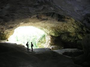
“The archaeological evidence tells us that between 2,800 and 2,600 BC two very different cultures co-existed in southern Scandinavia: there was the local, Neolithic culture known as the Funnel Beaker Culture with its characteristic funnel-shaped ceramics and collective burial practices and the new Single Grave Culture influenced by the Yamnaya culture. The Funnel Beaker Culture was eventually superseded by the Single Grave Culture, but the transition took hundreds of years in the eastern part of southern Scandinavia, and the two cultures must have influenced each other during this time, “says archaeologist Rune Iversen, who has specialised in this particular transitional period.
Peas, beans, turnips and shrimps
Historical linguist Guus Kroonen points to a number of words for local flora and fauna and important plant domesticates that the incoming speakers of Indo-European could not have brought with them to southern Scandinavia.
“There is a cluster of words in European languages such as Danish, English, and German – the Germanic languages – which stand out because they do not conform to the established sound changes of Indo-European vocabulary. It is words like sturgeon, shrimp, pea, bean and turnip that cannot be reconstructed to the Proto-Indo-European ancestor,” Guus Kroonen explains and adds:
“This tells us that these words must have entered Indo-European after it had spread from the Caspian steppe to the various parts of Europe. In other words: the new Single Grave Culture is likely to have adopted much farming and hunting terminology from the local Funnel Beaker Culture that inhabited southern Scandinavia and Denmark till around 2,600 BC. When Indo-European in Northern Europe developed into Proto-Germanic, the terminology for local flora and fauna was preserved, which is why we know and can study the terms today.”
Guus Kroonen adds that this farming terminology may be vestiges of a now extinct language spoken by the people who initially brought farming to Europe from Anatolia 9,000-6,000 years ago.
_______________________________________
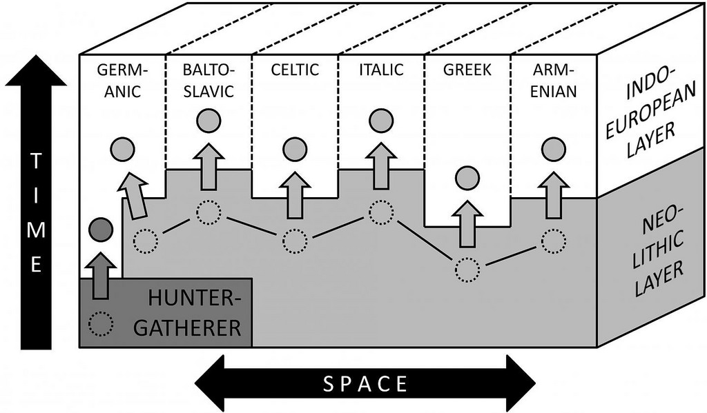
This is a schematic impression of how the different Indo-European branches may have absorbed lexical items (circles) from previously spoken languages in the linguistically complex setting of Europe from the third millennium BC. Credit: University of Copenhagen
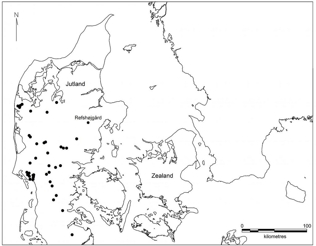
This is the distribution of the earliest Single Grave culture burials in southern Scandinavia, ca. 2850-2800. The Single Grave Culture co-existed with the local Funnel Beaker Culture, which inhabited the island of Zealand, for 200 years. Credit: University of Copenhagen
*Rune Iversen’s and Guus Kroonen’s paper, Talking Neolithic: Linguistic and Archaeological Perspectives on How Indo-European Was Implemented in Southern Scandinavia in American Journal of Archaeology.
Receive 30 days free access to the popular new CuriosityStream lineup of documentaries on science, history, nature, and technology as a new Popular Archaeology premium subscriber.
UPPSALA UNIVERSITY—A genomic analysis of ancient human remains from KwaZulu-Natal revealed that southern Africa has an important role to play in writing the history of humankind. A research team from Uppsala University, Sweden, the Universities of Johannesburg and the Witwatersrand, South Africa, presents their results in the September 28th early online issue of Science.
The team sequenced the genomes of seven individuals who lived in southern Africa 2300-300 years ago. The three oldest individuals dating to 2300-1800 years ago were genetically related to the descendants of the southern Khoe-San groups, and the four younger individuals who lived 500-300 years ago were genetically related to current-day South African Bantu-speaking groups. “This illustrates the population replacement that occurred in southern Africa”, says co-first author Carina Schlebusch, population geneticist at Uppsala University.
The authors estimate the divergence among modern humans to have occurred between 350,000 and 260,000 years ago, based on the ancient Stone Age hunter-gatherer genomes. The deepest split time of 350,000 years ago represents a comparison between an ancient Stone Age hunter-gatherer boy from Ballito Bay on the east coast of South Africa and the West African Mandinka. “This means that modern humans emerged earlier than previously thought”, says Mattias Jakobsson, population geneticist at Uppsala University who headed the project together with Stone Age archaeologist Marlize Lombard at the University of Johannesburg.
The fossil record of east Africa, and in particular the Omo and Herto fossils have often been used to set the emergence of anatomically modern humans to about 180,000 years ago. The deeper estimate for modern human divergence at 350,000-260,000 years ago coincides with the Florisbad and Hoedjiespunt fossils, contemporaries of the small-brained Homo naledi in southern Africa. “It now seems that at least two or three Homo species occupied the southern African landscape during this time period, which also represents the early phases of the Middle Stone Age”, says Marlize Lombard. It will be interesting to see in the future if we find any evidence of interaction between these groups.
“We did not find any evidence of deep structure or archaic admixture among southern African Stone Age hunter-gatherers. Instead, we see some evidence for deep structure in the West African population, but that affects only a small fraction of their genome and is about the same age as the deepest divergence among all humans”, says Mattias Jakobsson.
The authors also found that all current-day Khoe-San populations admixed with migrant East African pastoralists a little over a thousand years ago. “We could not detect this widespread East African admixture previously since we did not have an un-admixed San group to use as reference. Now that we have access to ancient DNA of people who lived on the landscape before the East African migration, we are able to detect the admixture percentages in all San groups. The admixture percentages in the Khoekhoe, historically identified as pastoralists, are higher than previously estimated”, says Carina Schlebusch.
Of the Iron Age individuals, three carry at least one Duffy null allele, protecting against malaria, and two have at least one sleeping-sickness-resistance variant in the APOL1 gene. The Stone Age individuals do not carry these protective alleles. “This tells us that Iron Age farmers carried these disease-resistance variants when they migrated to southern Africa”, says co-first author Helena Malmström, archaeo-geneticist at Uppsala University.
Marlize Lombard said that “archaeological deposits dating to the time of the split by 350,000-260,000 years ago, attest to South Africa being populated by tool-making hunter-gatherers at the time. Although human fossils are sparse, those of Florisbad and Hoedjiespunt are seen as transitional to modern humans.” These fossils may therefore be ancestral to the Ballito Bay boy and other San hunter-gatherers who lived in southern Africa 2000 years ago.
The transition from archaic to modern humans might not have occurred in one place in Africa but in several, including southern Africa and northern Africa as recently reported. “Thus, both palaeo-anthropological and genetic evidence increasingly points to multiregional origins of anatomically modern humans in Africa, i.e. Homo sapiens did not originate in one place in Africa, but might have evolved from older forms in several places on the continent with gene flow between groups from different places”, says Carina Schlebusch.
“It is remarkable that we can now sequence entire genomes of ancient human remains from tropical areas, such as the southeast coast of South Africa”, says Helena Malmström. This is promising for our several ongoing investigations in Africa.
____________________________________
Dr. Helena Malmström conducting on-site sampling of bone material in a mobil sampling lab. Credit: Uppsala University
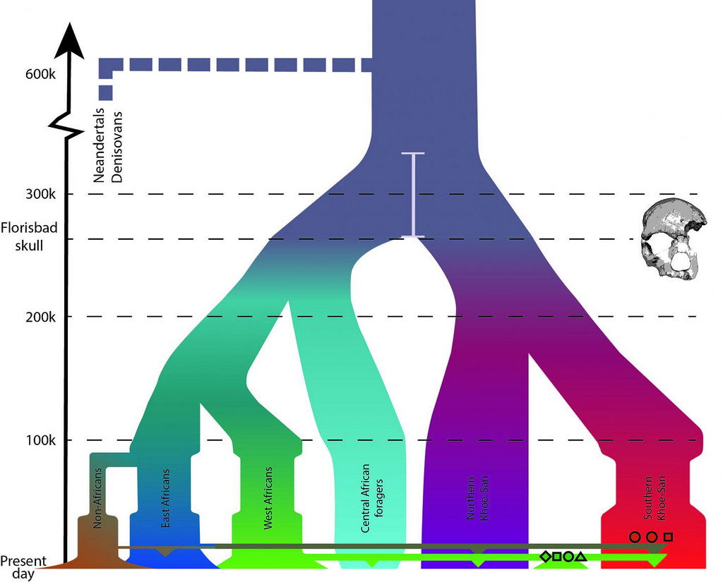
Demographic model of African history and estimated divergences. Vertical colored lines represent migration, with down-pointing triangles representing admixture into another group. Southern African hunter-gatherers are shown by red symbols, and Iron Age farmers as green symbols. Extracted from figure 3. Credit: Uppsala University
________________________________________________
Cumulatively these findings shed new light on our species’ deep African history and show that there is still much more to learn about our process of becoming modern humans and that the interplay between genetics and archaeology has an increasingly important role to play.
This article source: Edited from the Uppsala University news release
_________________________________________________
Receive 30 days free access to the popular new CuriosityStream lineup of documentaries on science, history, nature, and technology as a new Popular Archaeology premium subscriber.
PLOS—An isotopic analysis of megalithic graves and caves in Spain may suggest the existence of a degree of differentiation in the lifeways of people buried in these different funerary sites, according to a study* published September 27, 2017 in the open-access journal PLOS ONE by Teresa Fernández-Crespo and Rick Schulting from the University of the Basque Country, Spain, and the University of Oxford, UK.
Previous research on the burial practices of the Western European Neolithic has revealed variation in burial location and treatment, but their significance is difficult to interpret. To further investigate the meaning behind different burial practices within the same location and period, the authors of the present study analyzed the bone collagen carbon and nitrogen isotope measurements of 166 individuals from a series of broadly contemporary Late Neolithic (3500 to 2900 cal BC) mortuary monuments and caves, closely situated together in north-central Spain.
The researchers’ isotopic analysis of both megalithic graves and caves suggests a similar C3 plant-based human diet, mostly consisting of wheat and barley, as well as a substantial amount of protein from cattle and sheep. However, the study surprisingly reveals significant carbon isotope differences between people interred in both funerary site-types. These differences seem to be correlated with elevation, temperature, and precipitation, implying that land use was partitioned on a surprisingly local scale. The authors propose two possible explanations. The first is that this division of land could indicate different socioeconomic classes within the same community, with the lower classes being interred in caves with restricted access to agricultural resources, while the individuals of higher status in the community were buried in monumental graves whose construction would involve a considerable investment of labor. Alternatively, they also consider the possibility that this partitioning of the landscape may involve different populations performing different funerary practices and following distinct subsistence economies in some respect.
Further research on tooth dentine and enamel will explore the age at which the isotopic differences first appeared and investigate different patterns of mobility and landscape-use in the study area. This study offers new insights into different mortuary practices and specifically how they related to lifeways, particularly dietary and subsistence practices, and implications for the emergence of socioeconomic inequality in the Western European Neolithic.
“Using carbon and nitrogen stable isotope analysis of human and animal remains, our study has identified meaningful differences between those buried in caves and megalithic graves in the Late Neolithic of north-central Spain,” says Teresa Fernández-Crespo. “This implies that, despite living in close proximity, these communities had distinct lifeways involving a partitioning of the landscape.”
________________________________
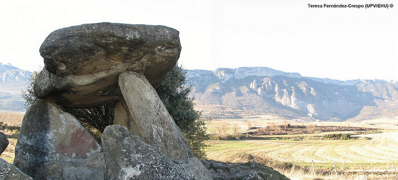
Megalithic graves analysed (Chabola de la Hechicera), and in the background, the Cantabria mountain range, where the caves included in the study are located. Credit: Teresa Fernández-Crespo / UPV/EHU
Receive 30 days free access to the popular new CuriosityStream lineup of documentaries on science, history, nature, and technology as a new Popular Archaeology premium subscriber.
DARTMOUTH COLLEGE—A Dartmouth-led study has demonstrated how the latest aerial thermal imagery is transforming archaeology due to advancements in technology. Today’s thermal cameras, commercial drones and photogrammetric software has introduced a new realm of possibilities for collecting site data. The findings, published in Advances in Archaeological Practice, serve as a manual on how to use aerial thermography, as the co-authors hope to inspire other researchers to apply this methodology in their work.
Archaeologists have long used thermal infrared images to locate buried architecture and other cultural landscape elements. The thermal infrared radiation associated with such archaeological features depends on several variables, including the make-up of the soil, its moisture content and vegetation cover. Past conventional geophysics methods, such as fieldwalking, enabled archaeologists to obtain field data across one hectare of a site per day. But now, aerial thermography makes it possible to gather field survey data across a much larger area in much less time.
New aerial thermography has other advantages, as well. Older cameras were unable to record full spectrum data or temperature data for every pixel of an image. Today’s radiometric thermal cameras coupled with small inexpensive, easy to fly drones, which can be controlled by a smartphone or tablet, have made aerial thermography more accurate, comprehensive and accessible. Mapping multiple aerial images together has also become easier through new photogrammetric software, which automatically aligns images and features ortho-image capabilities, which corrects an image to make the scale uniform.
The researchers conducted case studies at six archaeological sites in North America, the Mediterranean and the Middle East, to assess the effectiveness of aerial thermal surveys. They analyzed how weather, environment, time of day, ground cover, and archaeological features may affect the results, and compared their findings to earlier research and historical images.
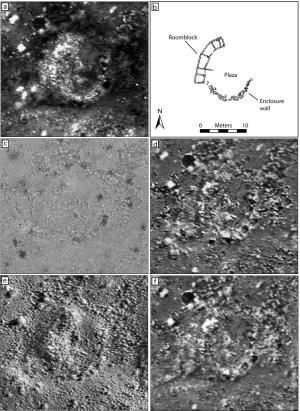
For example, at an ancestral Pueblo settlement in Blue J, N.M, the researchers were able to map detailed architectural plans of a dozen ancient house compounds—a discovery enabled by the site’s optimal conditions, the soil matrix, low density ground cover, and the environmental conditions at the time of the aerial thermography. They were also able to recognize traces of long-removed historic buildings and pathways at the Shaker Village in Enfield, N.H.
“A lot of what we’ve learned from our research to date shows how much local environmental conditions and the timing of surveys can impact how well thermal imagery will reveal archaeological remains. Yet, the more we understand these issues, the better we are able to deploy the technology. I think our results demonstrate aerial thermography’s potential to transform how we explore archaeological landscapes in many parts of the world,” says Jesse Casana, an associate professor of anthropology at Dartmouth, who has been using drones in aerial thermography for five years in his archaeological research.
__________________________________
Figure 4 from the paper/File photos from 2014: A Chaco-era room block (LA 170609) at Blue J, NM as it appears in (a) 5:18 a.m. thermal image; (b) architectural plan produced by test excavations; (c) a color image, and thermal images from (d) 6:18 a.m.; (e) 7:18 a.m.; and (f) 9:58 p.m. (Images by Jesse Casana, John Kantner, Adam Wiewel, and Jackson Cothren). Images are by Jesse Casana, John Kanter, Adam Wiewel, and Jackson Cothren. 2014 Archaeological Aerial Thermography: A Case Study at the Chaco-Era Blue J Community, New Mexico. Journal of Archaeological Science. 45:207-219
_____________________________________________
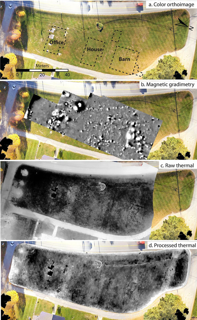
Figure 10 from the paper. (a) Color orthoimage of a survey area at the Enfield Shaker Village, New Hampshire, showing location of historic buildings indicated on a 1917 map; (b) magnetic gradiometry survey data; (c) raw thermal imagery collected with a radiometric thermal camera; and (d) thermal imagery processed to show only values present in the lawn. (Images by Jesse Casana, Austin Chad Hill and Elise Laugier). Images by Jesse Casana.
Receive 30 days free access to the popular new CuriosityStream lineup of documentaries on science, history, nature, and technology as a new Popular Archaeology premium subscriber.
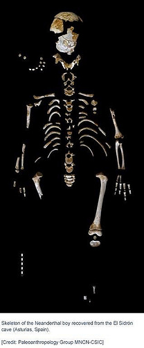
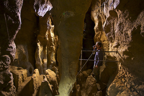
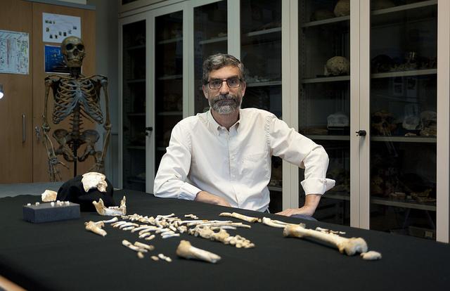
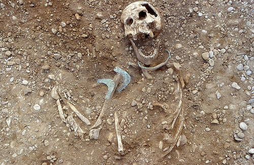
A new analysis of a well-preserved, remarkably complete Neanderthal child’s skeleton reveals that Neanderthals may have had a more extended period of brain growth compared to modern humans. An understanding of our Neanderthal cousins can provide important insights into our own biology. Of particular interest are differences in brain size, as the Neanderthal fossil record has thus far indicated that they had a larger cranial capacity than that of modern humans.
Some studies have proposed that the larger brain in Neanderthals can be explained by a faster rate of early postnatal growth, yet others have proposed a longer growth rate instead. Here, Antonio Rosas and colleagues describe a juvenile Neanderthal skeleton from the 49,000-year-old site of El Sidrón, in Spain. The specimen, dubbed El Sidrón J1, exhibits an exceptionally well-preserved mix of baby and adult teeth, providing a rare opportunity to estimate an age at death from daily dental incremental markings preserved in the teeth – leading the team to estimate that the child died at 7.69 years of age. Analysis of El Sidrón J1 also reveals that some vertebrae had still not fused in the 7-year-old Neanderthal, yet these same vertebrae tend to fuse in modern day humans around the ages of 4 to 6. Interestingly, the brain of El Sidrón J1 was roughly 87.5% of the size of an average adult Neanderthal brain upon death, whereas modern humans tend to have on average 95% of adult brain weight by that same age. The authors suggest that the unique pattern of vertebral maturation and extended brain growth might reflect the broad Neanderthal body form and physiology, rather than a fundamental difference in the overall pace of growth in Neanderthals.
It is important to note that, while Rosas and colleagues have identified these differences between the Neanderthal and the modern human, or Homo sapiens, for the most part, their growth development is very similar.
The El Sidrón Cave is a limestone karst cave system located in Asturias, northwestern Spain. Here, Paleolithic rock art and more than a dozen fossils of Neanderthals and 53 associated stone tools were found. The discovery was initially made accidentally in 1994, eventually revealing the remains of what scientists identified to be 13 individuals, including adolescent boys, a younger juvenile, women, and infants, dated to about 49,000 years ago. Analysis of the bones suggested that they may have been dropped into the cave in a single ancient event via a collapse of nearby fissures above the site, or by the influx of storm water.
The first sequencing of the Neanderthal Y chromosome was successfully achieved using a bone sample taken from the El Sidrón Cave. The results of DNA analysis indicated that Neanderthals diverged from a common ancestor with modern humans around 590,000 years ago.
Other research on the El Sidrón Neanderthals has shown that their diet consisted primarily of pine nuts, moss and mushrooms, unlike the primarily carnivorous diet of other Neanderthals.
Regarding this most recent study, Rosas and colleagues emphasize that this is really ony a first step, and future research will entail analyzing the remains of Neanderthals from the site and other sites, to increase the overall sample size under study to either qualify or further verify or validate their findings.
_________________________________
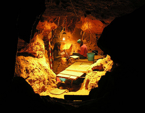
Researchers working inside the El Sidrón cave. Credit: Paleoanthropology group MNCN – CSIC
_____________________________________________
Antonio Rosas inside the El Sidrón cave. Credit: Joan Costa – CSIC Communication
_______________________________________________
Antonio Rosas beside the Neanderthal child’s skeleton. Credit: Andrés Diaz – CSIC Communication
Receive 30 days free access to the popular new CuriosityStream lineup of documentaries on science, history, nature, and technology as a new Popular Archaeology premium subscriber.
HARVARD MEDICAL SCHOOL—The first large-scale study of ancient human DNA from sub-Saharan Africa opens a long-awaited window into the identity of prehistoric populations in the region and how they moved around and replaced one another over the past 8,000 years.
The findings, published Sept. 21 in Cell by an international research team led by Harvard Medical School, answer several longstanding mysteries and uncover surprising details about sub-Saharan African ancestry — including genetic adaptations for a hunter-gatherer lifestyle and the first glimpses of population distribution before farmers and animal herders swept across the continent about 3,000 years ago.
“The last few thousand years were an incredibly rich and formative period that is key to understanding how populations in Africa got to where they are today,” said David Reich, professor of genetics at HMS and a senior associate member of the Broad Institute of MIT and Harvard. “Ancestry during this time period is such an unexplored landscape that everything we learned was new.”
Reich shares senior authorship of the study with Ron Pinhasi of the University of Vienna and Johannes Krause of the Max Planck Institute for the Science of Human History and the University of Tübingen in Germany.
“Ancient DNA is the only tool we have for characterizing past genomic diversity. It teaches us things we don’t know about history from archaeology and linguistics and can help us better understand present-day populations,” said Pontus Skoglund, a postdoctoral researcher in the Reich lab and the study’s first author. “We need to ensure we use it for the benefit of all populations around the world, perhaps especially Africa, which contains the greatest human genetic diversity in the world but has been underserved by the genomics community.”
Long time coming
Although ancient-DNA research has revealed insights into the population histories of many areas of the world, delving into the deep ancestry of African groups wasn’t possible until recently because genetic material degrades too rapidly in warm, humid climates.
Technological advances–including the discovery by Pinhasi and colleagues that DNA persists longer in small, dense ear bones–are now beginning to break the climate barrier. Last year, Reich and colleagues used the new techniques to generate the first genome-wide data from the earliest farmers in the Near East, who lived between 8,000 and 12,000 years ago.
In the new study, Skoglund and team, including colleagues from South Africa, Malawi, Tanzania and Kenya, coaxed DNA from the remains of 15 ancient sub-Saharan Africans. The individuals came from a variety of geographic regions and ranged in age from about 500 to 8,500 years old.
The researchers compared these ancient genomes—along with the only other known ancient genome from the region, previously published in 2015—against those of nearly 600 present-day people from 59 African populations and 300 people from 142 non-African groups.
With each analysis, revelations rolled in.
“We are peeling back the first layers of the agricultural transition south of the Sahara,” said Skoglund. “Already we can see that there was a whole different landscape of populations just 2,000 or 3,000 years ago.”
Genomic time-lapse
Almost half of the team’s samples came from Malawi, providing a series of genomic snapshots from the same location across thousands of years.
The time-series divulged the existence of an ancient hunter-gatherer population the researchers hadn’t expected.
When agriculture spread in Europe and East Asia, farmers and animal herders expanded into new areas and mixed with the hunter-gatherers who lived there. Present-day populations thus inherited DNA from both groups.
The new study found evidence for similar movement and mixing in other parts of Africa, but after farmers reached Malawi, hunter-gatherers seem to have disappeared without contributing any detectable ancestry to the people who live there today.
“It looks like there was a complete population replacement,” said Reich. “We haven’t seen clear evidence for an event like this anywhere else.”
The Malawi snapshots also helped identify a population that spanned from the southern tip of Africa all the way to the equator about 1,400 years ago before fading away. That mysterious group shared ancestry with today’s Khoe-San people in southern Africa and left a few DNA traces in people from a group of islands thousands of miles away, off the coast of Tanzania.
“It’s amazing to see these populations in the DNA that don’t exist anymore,” said Reich. “It’s clear that gathering additional DNA samples will teach us much more.”
“The Khoe-San are such a genetically distinctive people, it was a surprise to find a closely related ancestor so far north just a couple of thousand years ago,” Reich added.
The new study also found that West Africans can trace their lineage back to a human ancestor that may have split off from other African populations even earlier than the Khoe-San.
Missing links
The research similarly shed light on the origins of another unique group, the Hadza people of East Africa.
“They have a distinct appearance, language and genetics, and some people speculated that, like the Khoe-San, they might represent a very early diverging group from other African populations,” said Reich. “Our study shows that instead, they’re somehow in the middle of everything.”
The Hadza, according to genomic comparisons, are today more closely related to non-Africans than to other Africans. The researchers hypothesize that the Hadza are direct descendants of the group that migrated out of Africa, and possibly spread within Africa as well, after about 50,000 years ago.
Another discovery lay in wait in East Africa.
Scientists had predicted the existence of an ancient population based on the observation that present-day people in southern Africa share ancestry with people in the Near East. The 3,000-year-old remains of a young girl in Tanzania provided the missing evidence.
Reich and colleagues suspect that the girl belonged to a herding population that contributed significant ancestry to present-day people from Ethiopia and Somalia down to South Africa. The ancient population was about one-third Eurasian, and the researchers were able to further pinpoint that ancestry to the Levant region.
“With this sample in hand, we can now say more about who these people were,” said Skoglund.
The finding put one mystery to rest while raising another: Present-day people in the Horn of Africa have additional Near Eastern ancestry that can’t be explained by the group to which the young girl belonged.
Natural selection
Finally, the study took a first step in using ancient DNA to understand genetic adaptation in African populations.
It required “squeezing water out of a stone” because the researchers were working with so few ancient samples, said Reich, but Skoglund was able to identify two regions of the genome that appear to have undergone natural selection in southern Africans.
One adaptation increased protection from ultraviolet radiation, which the researchers propose could be related to life in the Kalahari Desert. The other variant was located on genes related to taste buds, which the researchers point out can help people detect poisons in plants.
The researchers hope that their study encourages more investigation into the diverse genetic landscape of human populations in Africa, both past and present. Reich also said he hopes the work reminds people that African history didn’t end 50,000 years ago when groups of humans began migrating into the Near East and beyond.
“The late Stone Age in Africa is like a black hole, research-wise,” said Reich. “Ancient DNA can address that gap.”
________________________________
Mount Hora in Malawi, where the oldest DNA in the study, from a woman who lived more than 8,000 years ago, was obtained. Credit: Jessica C. Thompson/Emory University
Funding for this research was provided by the National Institutes of Health (grant GM100233), the National Science Foundation (HOMINID BCS-1032255 and BCS-1613577), the DFG/German Research Foundation (KR 4015/1-1), the Max Planck Society, the National Research Foundation of South Africa, the South African Medical Research Council, European Research Council starting grants SEALINKS (206148) and ADNABIOARC (263441), a Wellcome Trust Senior Investigator Award (100719/Z/12/Z), the Wenner-Gren Foundation and the Swedish Research Council (VR grant 2014-453). Reich is a Howard Hughes Medical Institute investigator.
There were a total of 44 study authors from institutions in 11 countries.
___________________________________________
Receive 30 days free access to the popular new CuriosityStream lineup of documentaries on science, history, nature, and technology as a new Popular Archaeology premium subscriber.
FRONTIERS—Easter Island, known as Rapa Nui by its inhabitants, has been surrounded in mystery ever since the Europeans first landed in 1722. Early visitors estimated a population of just 1,500-3,000, which seemed at odds with the nearly nine hundred giant statues dotted around the Island. How did this small community construct, transport and erect these large rock figures?
A new study, published in the open-access journal Frontiers in Ecology and Evolution, hopes to unravel this mystery by giving the best estimate yet of the maximum population size sustained by Easter Island in its heyday.
“Despite its almost complete isolation, the inhabitants of Easter Island created a complicated social structure and these amazing works of art before a dramatic change occurred,” says Dr. Cedric Puleston, lead author of this study, based at the Department of Anthropology, University of California, Davis, USA. “We’ve tried to solve one piece of the puzzle – to figure out the maximum population size before it fell. It appears the island could have supported 17,500 people at its peak, which represents the upper end of the range of previous estimates.”
He adds, “If the population fell from 17,500 to the small number that missionaries counted many years after European contact, it presents a very different picture from the maximum population of 3,000 or less that some have suggested.”
Previous archaeological evidence implies the indigenous people numbered far greater than the 1,500-3,000 individuals encountered in the 18th century. The population history of the island remains highly controversial. In addition to internal conflict, the population crash has been attributed to “ecocide,” in which the Island’s resources were exhausted by its inhabitants, reducing its ability to support human life.
Puleston and his colleagues examined the agricultural potential of the Island before these events occurred, to calculate how many people the Island could sustain.
“The project, funded by the U.S. National Science Foundation, involved a number of really good researchers, including archaeologists, a local expert in Rapa Nui culture, a soil scientist, a biogeochemist, and a population biologist, to get a thorough picture of what the island was like before European contact,” he explains.
“We examined detailed maps, took soil samples around the Island, placed weather stations, used population models and estimated sweet potato production. When we had doubts about one of these factors we looked at the range of its potential values to work out different scenarios.”
They found 19% of the Island could have been used to grow sweet potatoes, which was the main food crop. By using information on how birth and death rates at various ages depend on food availability, the researchers calculated the population size that level of production could sustain.
“The result is a wide range of possible maximum population sizes, but to get the smallest values you have to assume the worst of everything,” says Puleston. “If we compare our agriculture estimates with other Polynesian Islands, a population of 17,500 people on this size of island is entirely reasonable.”
He concludes, “Easter Island is fascinating because it represents an extreme example of a natural experiment in human adaptation, which began when people from a single cultural group spread quickly across the islands of the Pacific. The different environments they encountered on these islands generated a tremendous amount of variation in human behavior. As an extremely unusual case, in both its cultural achievements and its ecological transformation, Easter Island is remarkable and important. It retains an air of mystery, but it’s a real place and has a real history lived by real people. Dispelling that mystery brings us closer to understanding the nature of humanity.”
Receive 30 days free access to the popular new CuriosityStream lineup of documentaries on science, history, nature, and technology as a new Popular Archaeology premium subscriber.
DE GRUYTER OPEN—Name one civilization located in the Americas that pre-dates the arrival of Europeans. You probably replied with the Aztecs, the Inca or perhaps the Maya. A new paper, published in De Gruyter’s open access journal Open Archeology by Michael E. Smith of Arizona State University, shows how this view of American civilizations is narrow. It is entitled “The Teotihuacan Anomaly: The Historical Trajectory of Urban Design in Ancient Central Mexico”.
Smith, using a map produced by the Teotihuacan mapping project, conducted a comparative analysis of the city with earlier and later Mesoamerican urban centers and has proved, for the first time, the uniqueness of the city. The paper outlines how the urban design of the city of Teotihuacan differed from past and subsequent cities, only to be rediscovered and partially modeled many centuries later by the Aztecs.
Teotihuacan was in touch with other Mesoamerican civilizations and at the height of its influence between 100 – 650 AD it was the largest city in the Americas and one of the largest in the world. It is unclear who the builders of the city were and what relation they had to the peoples which followed. It is possible they were related to the Nahua or Totonac peoples. It is also unclear why the city was abandoned. There are several theories which include foreign invasion, a civil war, an ecological catastrophe, or some combination of all three.
The Aztecs, who reached the height of their power about a thousand years later, held Teotihuacan in reverence. The site of Teotihuacan is located about forty kilometers from the site of the Aztec capital. They claimed to be the descendants of the Teotihuacans. That may or may not be true, but the Teotihuacans had a huge influence on the later Aztec culture. The name Teotihuacan comes from the Aztec language, and means ‘the birthplace of the gods’ and they believed it was the location of the creation of the universe. But the paper outlines how the influence of this ancient culture on the Aztecs was not limited only to their cultural beliefs, but also how it affected the urban design of their capital city, and also how unparalleled that original design was. Most ancient cities throughout Mesoamerica followed the same planning principles, and they included the same kinds of buildings. Each city usually had a well-planned central area which included temples, a royal palace, a ballcourt, and a plaza that was surrounded by a much more chaotic (in terms of planning) residential area. Teotihuacan most likely had no royal palace, no ballcourt, and no central areas. It was much larger than cities before it, and the residential areas were much better planned than its predecessors, and it had an innovation unique in world history – the apartment compound. Buildings with one entrance that contained many households had been rare before the industrial revolution and those that did exist were for the poor. Teotihuacan’s were spacious and comfortable.
“Teotihuacan stood alone as the only city using a new and very different set of planning principles, and its apartment compounds represent a unique form of urban residence not just in Mesoamerica but in world urban history,” said Michael E. Smith.
All of these features were unique in Central America before and after, until the Aztecs drew their inspiration for their capital Tenochtitlan from Teotihuacan using many of the same features.
_______________________________________
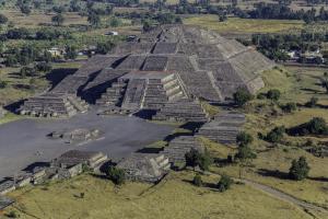
The Sun Pyramid in Teotihuacan. Credit: (CC BY-SA 3.0 license) by Ricardo David Sánchez
Receive 30 days free access to the popular new CuriosityStream lineup of documentaries on science, history, nature, and technology as a new Popular Archaeology premium subscriber.
WELLCOME TRUST SANGER INSTITUTE—The first large-scale genetic study of people in Papua New Guinea has shown that different groups within the country are genetically highly different from each other. Scientists at the Wellcome Trust Sanger Institute and their colleagues at the University of Oxford and the Papua New Guinea Institute of Medical Research reveal that the people there have remained genetically independent from Europe and Asia for most of the last 50,000 years, and that people from the country’s isolated highlands region have been completely independent even until the present day.
Reported today (15 September) in Science, the study also gives insights into how the development of agriculture and cultural events such as the Bronze or Iron Age could affect the genetic structure of human societies.
Papua New Guinea is a country in the southwestern Pacific with some of the earliest archaeological evidence of human existence outside Africa. Largely free from Western influence and with fascinating cultural diversity, it has been of enormous interest to anthropologists and other scientists seeking to understand human cultures and evolution.
With approximately 850 domestic languages, which account for over 10 per cent of the world’s total, Papua New Guinea is the most linguistically diverse country in the world. To discover if the linguistic and cultural diversity was echoed in the genetic structure of the population, researchers studied the genomes of 381 Papuan New Guinean people from 85 different language groups within the country.
The researchers looked at more than a million genetic positions in the genome of each individual, and compared them to investigate genetic similarities and differences. They found that groups of people speaking different languages were surprisingly genetically distinct from each other.
Anders Bergström, the first author on the paper from the Wellcome Trust Sanger Institute, said: “This is the first large-scale study of genetic diversity and population history in Papua New Guinea. Our study revealed that the genetic differences between groups of people there are generally very strong, often much stronger even than between major populations within all of Europe or all of East Asia.”
Professor Stephen J. Oppenheimer, second author of the paper from the Wellcome Trust Centre for Human Genetics, University of Oxford, said: “We found a striking difference between the groups of people who live in the mountainous highlands and those in the lowlands, with genetic separation dating back 10,000-20,000 years between the two. This makes sense culturally, as the highland groups historically have kept to themselves, but such a strong genetic barrier between otherwise geographically close groups is still very unusual and fascinating.”
Human evolution in Europe and Asia has been greatly influenced by the development of agriculture around 10,000 years ago. When small bands of hunter-gatherers settled into villages and started farming, they expanded and over time gave rise to more genetically homogenous (similar) societies. However, despite the independent development of agriculture in Papua New Guinea at about the same time, the same process of homogenization did not occur here. This may indicate that other historical processes in Europe and Asia, such as the later Bronze and Iron Ages, were the key events that shaped the current genetic structure of those populations.
Dr Chris Tyler-Smith, corresponding author on the paper from the Wellcome Trust Sanger Institute, said: “Using genetics, we were able to see that people on the island of New Guinea evolved independently from rest of the world for much of the last 50,000 years. This study allows us to glimpse a different version of human evolution from that in Europe and Asia, one in which there was agriculture but no later Bronze Age or Iron Age. Papua New Guinea might show the genetic, cultural and linguistic diversity that many settled human societies would have had before these technological transformations.”
___________________________________
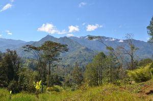
The highlands of Papua New Guinea. eGuide Travel, Wikimedia Commons
Receive 30 days free access to the popular new CuriosityStream lineup of documentaries on science, history, nature, and technology as a new Popular Archaeology premium subscriber.
UNIVERSITY OF CALIFORNIA – SAN DIEGO—Ancient DNA recovered from fossils is a valuable tool to study evolution and anthropology. Yet ancient fossil DNA from earlier geological ages has not been found yet in any part of Africa, where it’s destroyed by extreme heat and humidity. In a potential first step at overcoming this hurdle, researchers at University of California San Diego School of Medicine and Turkana Basin Institute in Kenya have discovered a new kind of glycan—a type of sugar chain—that survives even in a 4 million-year-old animal fossil from Kenya, under conditions where ancient DNA does not.
While ancient fossils from hominins (human ancestors and extinct relatives) are not yet available for glycan analysis, this proof-of-concept study, published September 11 in Proceedings of the National Academy of Sciences, may set the stage for unprecedented explorations of human origins and diet.
“In recent decades, many new hominin fossils were discovered and considered to be the ancestors of humans,” said Ajit Varki, MD, Distinguished Professor of Medicine and Cellular and Molecular Medicine at UC San Diego School of Medicine. “But it’s not possible that all gave rise to modern humans—it’s more likely that there were many human-like species over time, only one from which we descended. This new type of glycan we found may give us a better way to investigate which lineage is ours, as well as answer many other questions about our evolution, and our propensity to consume red meat.”
Glycans are complex sugar chains on the surfaces of all cells. They mediate interaction between cells and the environment, and often serve as docking sites for pathogens. For millions of years, the common ancestors of humans and other apes shared a particular glycan known as Neu5Gc. Then, for reasons possibly linked to a malarial parasite that exploited Neu5Gc as a means to establish infection, a mutation that probably occurred between 2 and 3 million years ago inactivated the human gene encoding the enzyme that makes the molecule. The loss of Neu5Gc amounted to a radical molecular makeover of human ancestral cell surfaces and might have created a fertility barrier that expedited the divergence of the lineage leading to humans.
Today, chimpanzees and most other mammals still produce Neu5Gc. In contrast, only trace amounts can be detected in human blood and tissue—not because we make Neu5Gc, but, according to a previous study by Varki’s team, because we accumulate the glycan when eating Neu5Gc rich red meat. Humans mount an immune response to this non-native Neu5Gc, possibly aggravating diseases such as cancer.
In their latest study, Varki and team found that, as part of its natural breakdown, a signature part of Neu5Gc is also incorporated into chondroitin sulfate (CS), an abundant component in bone. They detected this newly discovered molecule, called Gc-CS, in a variety of mammalian samples, including easily detectable amounts in chimpanzee bones and mouse tissues.
Like Neu5Gc, they found that human cells and serum have only trace amounts of Gc-CS—again, likely from red meat consumption. The researchers backed up that assumption with the finding that mice engineered to lack Neu5Gc and Gc-Cs (similar to humans) had detectable Gc-CS only when fed Neu5Gc-containing chow.
Curious to see how stable and long-lasting Gc-CS might be, Varki bought a relatively inexpensive 50,000-year-old cave bear fossil at a public fossil show and took it back to the lab. Despite its age, the fossil indeed contained Gc-CS.
That’s when Varki turned to a long-time collaborator—paleoanthropologist and famed fossil hunter Meave Leakey, PhD, of Turkana Basin Institute of Kenya and Stony Brook University. Knowing that researchers need to make a very strong case before they are given precious ancient hominin fossil samples, even for DNA analysis, Leakey recommended that the researchers first prove their method by detecting Gc-CS in even older animal fossils. To that end, with the permission of the National Museums of Kenya, she gave them a fragment of a 4-million-year-old fossil from a buffalo-like animal recovered in the excavation of a bone bed at Allia Bay, in the Turkana Basin of northern Kenya. Hominin fossils were also recovered from the same horizon in this bone bed.
Varki and team were still able to recover Gc-CS in these much older fossils. If they eventually find Gc-Cs in ancient hominin fossils as well, the researchers say it could open up all kinds of interesting possibilities.
“Once we’ve refined our technique to the point that we need smaller sample amounts and are able to obtain ancient hominin fossils from Africa, we may eventually be able to classify them into two groups—those that have Gc-CS and those that do not. Those that lack the molecule would mostly likely belong to the lineage that led to modern humans,” said Varki, who is also adjunct professor at the Salk Institute for Biological Studies and co-director of the UC San Diego/Salk Center for Academic Research and Training in Anthropogeny (CARTA).
In a parallel line of inquiry, Varki hopes Gc-CS detection will also reveal the point in evolution when humans began consuming large amounts of red meat.
“It’s possible we’ll one day find three groups of hominin fossils—those with Gc-CS before the human lineage branched off, those without Gc-CS in our direct lineage, and then more recent fossils in which trace amounts of Gc-CS began to reappear when our ancestors began eating red meat,” Varki said. “Or maybe our ancestors lost Gc-CS more gradually, or only after we began eating red meat. It will be interesting to see, and we can begin asking these questions now that we know we can reliably find Gc-CS in ancient fossils in Africa.”
Leakey is also hopeful about the role Gc-CS could play in the future, as an alternative to current approaches.
“Because DNA rapidly degrades in the tropics, genetic studies are not possible in fossils of human ancestors older than only a few thousand years,” she said. “Therefore such ancient glycan studies have the potential to provide a new and important method for the investigation of human origins.”
_________________________________
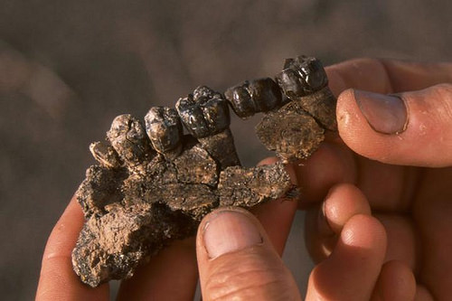
Partial upper jaw of Australopithecus anamensis, a primitive hominin, recovered from the bone bed excavated at the Allia Bay site. Photo courtesy of Meave Leakey, PhD
Excavation of the bone bed at the Allia Bay site, East Turkana, in 1996. A cross section of the bone bed can be seen passing diagonally from the center of the image to the right hand corner. This is the site where researchers collected a 4-million-year-old bovid fossil that contained Gc-CS. Photo courtesy of Meave Leakey, PhD.
_________________________________
Co-authors of this study also include: Anne K. Bergfeld, Roger Lawrence, Sandra L. Diaz, Oliver M.T. Pearce, Darius Ghaderi, and Pascal Gagneux, all at UC San Diego.
Receive 30 days free access to the popular new CuriosityStream lineup of documentaries on science, history, nature, and technology as a new Popular Archaeology premium subscriber.
This richly illustrated issue includes the following stories: Recent findings shedding new light on the whereabouts of the remains of Philip of Macedon, father of Alexander the Great; how an archaeologist-sculptor is bringing bones of the dead back to life; archaeologists uncovering town life at the dawn of civilization; an exclusive interview with internationally acclaimed archaeologist James M. Adovasio about what makes the Meadowcroft Rockshelter prominent in the ongoing search for the first Americans; what archaeologists are finding at the site of the ancient city of Gath, the home town of the biblical Philistine giant, Goliath; and how scientists are redrawing the picture of human evolution in Europe. Find it on Amazon.com.
STOCKHOLM UNIVERSITY—War was not an activity exclusive to males in the Viking world. A new study conducted by researchers at Stockholm and Uppsala Universities shows that women could be found in the higher ranks at the battlefield.
Charlotte Hedenstierna-Jonson, who led the study, explains: “What we have studied was not a Valkyrie from the sagas but a real life military leader, that happens to be a woman”.
The study was conducted on one of the most iconic graves from the Viking Age. It holds the remains of a warrior surrounded by weapons, including a sword, armour-piercing arrows, and two horses. There were also a full set of gaming pieces and a gaming board. “The gaming set indicates that she was an officer”, says Charlotte, “someone who worked with tactics and strategy and could lead troops in battle”. The warrior was buried in the Viking town of Birka during the mid-10th century. Isotope analyses confirm an itinerant life style, well in tune with the martial society that dominated 8th to 10th century northern Europe.
Anna Kjellström, who also participated in the study, has taken an interest in the burial previously. “The morphology of some skeletal traits strongly suggests that she was a woman, but this has been the type specimen for a Viking warrior for over a century why we needed to confirm the sex in any way we could.”
And this is why the archaeologists turned to genetics, to retrieve a molecular sex identification based on X and Y chromosomes. Such analyses can be quite useful according to Maja Krezwinska: “Using ancient DNA for sex identification is useful when working with children for example, but can also help to resolve controversial cases such as this one”. Maja was thus able to confirm the morphological sex identification with the presence of X chromosomes but the lack of a Y chromosome.
Jan Storå, who holds the senior position on this study, reflects over the history of the material: “This burial was excavated in the 1880ies and has served as a model of a professional Viking warrior ever since. Especially, the grave-goods cemented an interpretation for over a century”. It was just assumed she was a man through all these years. “The utilization of new techniques, methods, but also renewed critical perspectives, again, shows the research potential and scientific value of our museum collections”.
The study is a part of the ongoing ATLAS project, which is a joint effort by Stockholm University and Uppsala University, supported by Riksbankens Jubileumsfond (The Swedish Foundation for Humanities and Social Sciences) and Vetenskapsrådet (The Swedish Research Council), to investigate the genetic history of Scandinavia.
Receive 30 days free access to the popular new CuriosityStream lineup of documentaries on science, history, nature, and technology as a new Popular Archaeology premium subscriber.
This richly illustrated issue includes the following stories: Recent findings shedding new light on the whereabouts of the remains of Philip of Macedon, father of Alexander the Great; how an archaeologist-sculptor is bringing bones of the dead back to life; archaeologists uncovering town life at the dawn of civilization; an exclusive interview with internationally acclaimed archaeologist James M. Adovasio about what makes the Meadowcroft Rockshelter prominent in the ongoing search for the first Americans; what archaeologists are finding at the site of the ancient city of Gath, the home town of the biblical Philistine giant, Goliath; and how scientists are redrawing the picture of human evolution in Europe. Find it on Amazon.com.
PROCEEDINGS OF THE NATIONAL ACADEMY OF SCIENCES—Researchers report ages of Neanderthal remains using an improved dating technique. Neanderthal remains from Vindija Cave in northern Croatia have been previously dated at approximately 32,000 years old, making them the most recent known Neanderthal remains and implying considerable temporal overlap between Neanderthals and modern humans in Central Europe. Thibaut Deviese and colleagues dated four Neanderthal bone samples from Vindija, one of which was previously unidentified, by extracting the amino acid hydroxyproline (HYP) from bone collagen. Because HYP occurs almost exclusively in collagen, dating purified HYP removed modern contaminants, including conservation materials, from the specimens. The authors obtained dates older than 40,000 years for all four sets of Neanderthal remains, far older than previously obtained dates. Dating of animal bones from the same layer as the Neanderthal bones yielded a wide range of dates. The finding suggests that postdepositional mixing of material has occurred, and therefore Upper Paleolithic tools found alongside the Neanderthal bones may not necessarily date from the same period. The Neanderthals at Vindija Cave likely did not overlap with modern humans, and were not part of a late-surviving, refugial population as previously thought, according to the authors.
_______________________________________
Vindija Cave in Croatia, which was occupied by Neanderthals more than 40,000 years ago. Credit: Image courtesy of Ivor Karavani
*”Direct dating of Neanderthal remains from the site of Vindija Cave and implications for the Middle to Upper Paleolithic transition,” by Thibaut Deviese et al.
Receive 30 days free access to the popular new CuriosityStream lineup of documentaries on science, history, nature, and technology as a new Popular Archaeology premium subscriber.
This richly illustrated issue includes the following stories: Recent findings shedding new light on the whereabouts of the remains of Philip of Macedon, father of Alexander the Great; how an archaeologist-sculptor is bringing bones of the dead back to life; archaeologists uncovering town life at the dawn of civilization; an exclusive interview with internationally acclaimed archaeologist James M. Adovasio about what makes the Meadowcroft Rockshelter prominent in the ongoing search for the first Americans; what archaeologists are finding at the site of the ancient city of Gath, the home town of the biblical Philistine giant, Goliath; and how scientists are redrawing the picture of human evolution in Europe. Find it on Amazon.com.
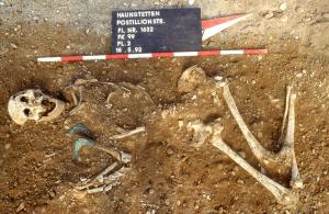
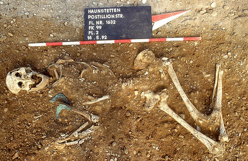
MAX PLANCK INSTITUTE FOR THE SCIENCE OF HUMAN HISTORY—At the end of the Stone Age and in the early Bronze Age, families were established in a surprising manner in the Lechtal, south of Augsburg, Germany. The majority of women came from outside the area, probably from Bohemia or Central Germany, while men usually remained in the region of their birth. This so-called patrilocal pattern combined with individual female mobility was not a temporary phenomenon, but persisted over a period of 800 years during the transition from the Neolithic to the Early Bronze Age.
The findings, published today in PNAS, result from a research collaboration headed by Philipp Stockhammer of the Institute of Pre- and Protohistoric Archaeology and Archaeology of the Roman Provinces of the Ludwig-Maximilians-Universität München. In addition to archaeological examinations, the team conducted stable isotope and ancient DNA analyses. Corina Knipper of the Curt-Engelhorn-Centre for Archaeometry, as well as Alissa Mittnik and Johannes Krause of the Max Planck Institute for the Science of Human History in Jena and the University of Tuebingen jointly directed these scientific investigations. “Individual mobility was a major feature characterizing the lives of people in Central Europe even in the 3rd and early 2nd millennium,” states Philipp Stockhammer. The researchers suspect that it played a significant role in the exchange of cultural objects and ideas, which increased considerably in the Bronze Age, in turn promoting the development of new technologies.
For this study*, the researchers examined the remains of 84 individuals using genetic and isotope analyses in conjunction with archeological evaluations. The individuals were buried between 2500 and 1650 BC in cemeteries that belonged to individual homesteads, and that contained between one and several dozen burials made over a period of several generations. “The settlements were located along a fertile loess ridge in the middle of the Lech valley. Larger villages did not exist in the Lechtal at this time,” states Stockhammer.
“We see a great diversity of different female lineages, which would occur if over time many women relocated to the Lech Valley from somewhere else,” remarks Alissa Mittnik on the genetic analyses. Corina Knipper also explains, “Based on analysis of strontium isotope ratios in molars, which allows us to draw conclusions about the origin of people, we were able to ascertain that the majority of women did not originate from the region.” The burials of the women did not differ from that of the native population, indicating that the formerly foreign women were integrated into the local community.
_____________________________________
Above and below: Examinaion of these burial remains indicates that, 4,000 years ago, European women traveled far from their home villages to start their families, bringing with them new cultural objects and ideas. Credit: Stadtarchäologie Augsburg
From an archaeological point of view, the new insights prove the importance of female mobility for cultural exchange in the Bronze Age. They also allow us to view the immense extent of early human mobility in a new light. “It appears that at least part of what was previously believed to be migration by groups is based on an institutionalized form of individual mobility,” declares Stockhammer.
*“Female exogamy and gene pool diversification at the transition from the Final Neolithic to the Early Bronze Age in central Europe,” by Corina Knipper et al.
_________________________________________________
Receive 30 days free access to the popular new CuriosityStream lineup of documentaries on science, history, nature, and technology as a new Popular Archaeology premium subscriber.
This richly illustrated issue includes the following stories: Recent findings shedding new light on the whereabouts of the remains of Philip of Macedon, father of Alexander the Great; how an archaeologist-sculptor is bringing bones of the dead back to life; archaeologists uncovering town life at the dawn of civilization; an exclusive interview with internationally acclaimed archaeologist James M. Adovasio about what makes the Meadowcroft Rockshelter prominent in the ongoing search for the first Americans; what archaeologists are finding at the site of the ancient city of Gath, the home town of the biblical Philistine giant, Goliath; and how scientists are redrawing the picture of human evolution in Europe. Find it on Amazon.com.
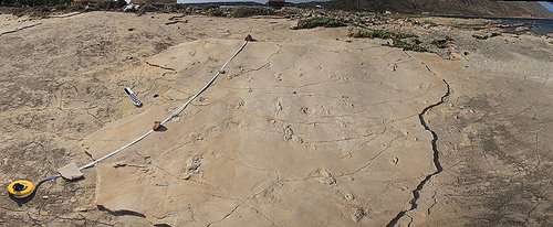
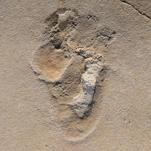
UPPSALA UNIVERSITY—Newly discovered human-like footprints from Crete may put the established narrative of early human evolution to the test. The footprints are approximately 5.7 million years old and were made at a time when previous research puts our ancestors in Africa – with ape-like feet.
Ever since the discovery of fossils of Australopithecus in South and East Africa during the middle years of the 20th century, the origin of the human lineage has been thought to lie in Africa. More recent fossil discoveries in the same region, including the iconic 3.7 million year old Laetoli footprints from Tanzania which show human-like feet and upright locomotion, have cemented the idea that hominins (early members of the human lineage) not only originated in Africa but remained isolated there for several million years before dispersing to Europe and Asia. The discovery of approximately 5.7 million year old human-like footprints from Crete, published online this week by an international team of researchers, overthrows this simple picture and suggests a more complex reality.
Human feet have a very distinctive shape, different from all other land animals. The combination of a long sole, five short forward-pointing toes without claws, and a hallux (“big toe”) that is larger than the other toes, is unique. The feet of our closest relatives, the great apes, look more like a human hand with a thumb-like hallux that sticks out to the side. The Laetoli footprints, thought to have been made by Australopithecus, are quite similar to those of modern humans except that the heel is narrower and the sole lacks a proper arch. By contrast, the 4.4 million year old Ardipithecus ramidus from Ethiopia, the oldest hominin known from reasonably complete fossils, has an ape-like foot. The researchers who described Ardipithecus argued that it is a direct ancestor of later hominins, implying that a human-like foot had not yet evolved at that time.
The new footprints, from Trachilos in western Crete, have an unmistakably human-like form. This is especially true of the toes. The big toe is similar to our own in shape, size and position; it is also associated with a distinct ‘ball’ on the sole, which is never present in apes. The sole of the foot is proportionately shorter than in the Laetoli prints, but it has the same general form. In short, the shape of the Trachilos prints indicates unambiguously that they belong to an early hominin, somewhat more primitive than the Laetoli trackmaker. They were made on a sandy seashore, possibly a small river delta, whereas the Laetoli tracks were made in volcanic ash.
‘What makes this controversial is the age and location of the prints,’ says Professor Per Ahlberg at Uppsala University, last author of the study.
At approximately 5.7 million years, they are younger than the oldest known fossil hominin, Sahelanthropus from Chad, and contemporary with Orrorin from Kenya, but more than a million years older than Ardipithecus ramidus with its ape-like feet. This conflicts with the hypothesis that Ardipithecus is a direct ancestor of later hominins. Furthermore, until this year, all fossil hominins older than 1.8 million years (the age of early Homo fossils from Georgia) came from Africa, leading most researchers to conclude that this was where the group evolved. However, the Trachilos footprints are securely dated using a combination of foraminifera (marine microfossils) from over- and underlying beds, plus the fact that they lie just below a very distinctive sedimentary rock formed when the Mediterranean sea briefly dried out, 5.6 millon years ago. By curious coincidence, earlier this year, another group of researchers reinterpreted the fragmentary 7.2 million year old primate Graecopithecus from Greece and Bulgaria as a hominin. Graecopithecus is only known from teeth and jaws.
__________________________________
Above and below: The footprints were discovered by Gerard Gierlinski (1st author of the study) by chance when he was on holiday on Crete in 2002. Gierlinski, a paleontologist at the Polish Geological Institute specialized in footprints, identified the footprints as mammal but did not interpret them further at the time. In 2010 he returned to the site together with Grzegorz Niedzwiedzki (2nd author), a Polish paleontologist now at Uppsala University, to study the footprints in detail. Together they came to the conclusion that the footprints were made by hominins. Credit: Andrzej Boczarowski
__________________________________________
_____________________________________________
During the time when the Trachilos footprints were made, a period known as the late Miocene, the Sahara Desert did not exist; savannah-like environments extended from North Africa up around the eastern Mediterranean. Furthermore, Crete had not yet detached from the Greek mainland. It is thus not difficult to see how early hominins could have ranged across south-east Europe and well as Africa, and left their footprints on a Mediterranean shore that would one day form part of the island of Crete.
‘This discovery challenges the established narrative of early human evolution head-on and is likely to generate a lot of debate. Whether the human origins research community will accept fossil footprints as conclusive evidence of the presence of hominins in the Miocene of Crete remains to be seen,’ says Per Ahlberg.
Receive 30 days free access to the popular new CuriosityStream lineup of documentaries on science, history, nature, and technology as a new Popular Archaeology premium subscriber.
This richly illustrated issue includes the following stories: Recent findings shedding new light on the whereabouts of the remains of Philip of Macedon, father of Alexander the Great; how an archaeologist-sculptor is bringing bones of the dead back to life; archaeologists uncovering town life at the dawn of civilization; an exclusive interview with internationally acclaimed archaeologist James M. Adovasio about what makes the Meadowcroft Rockshelter prominent in the ongoing search for the first Americans; what archaeologists are finding at the site of the ancient city of Gath, the home town of the biblical Philistine giant, Goliath; and how scientists are redrawing the picture of human evolution in Europe. Find it on Amazon.com.
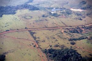
UNIVERSITY OF HELSINKI—Researchers examine pre-colonial geometric earthworks in the southwestern Amazonia from the point of view of indigenous peoples and archaeology. The study shows that the earthworks were once important ritual communication spaces.
The geometric earthworks of southwestern Amazonia have raised the interest within the scientific community as well as the media and the general public, and they have been explored recently by several international research teams.
These unique archaeological sites have been labeled the Geoglyphs of Acre, as most of them are located in the Brazilian State of Acre. Nearly 500 sites have already been registered and have been included on the Brazilian State Party’s Tentative List for inscription on the UNESCO World Heritage List.
The construction period and use, span the time period of approximately 3000-1000 BP. The earthwork ditches form geometric patterns, such as squares, circles, U-forms, ellipses and octagons. They can be several meters deep and enclose areas of hundreds of square meters.
Members of the community interacted with the environment
Pirjo Kristiina Virtanen, Assistant Professor of Indigenous Studies at the University of Helsinki, Finland, has conducted research with indigenous peoples in the study area for a long time. Sanna Saunaluoma, Post Doctoral researcher at the São Paulo University, Brazil, is specialized in Amazonian archeology and made her doctoral dissertation on Acre’s earthwork sites. Their article published in the American Anthropologist (119[4], 2017), already in early view, examines pre-colonial geometric earthworks from the point of view of indigenous peoples and archaeology.
The study shows that the sites were once important ritual spaces where, through the geometric designs, certain members of the community communicated with various beings of the environment, such as ancestor spirits, animals, and celestial bodies. Thus people were constantly reminded that human life was intertwined with the environment and previous generations. People did not distinguish themselves from nature, but nonhumans enabled and produced life.
The geometric earthwork sites were especially used by the experts of that era, who specialized in the interaction with the nonhuman beings. The sites were important for members of the community at certain stages of life, and the various geometric patterns acted as “doors” and “paths” to gain the knowledge and strength of the different beings of the environment. Visualization and active interactions with nonhuman beings were constructive for these communities.
Contemporary indigenous peoples of Acre still regard earthwork sites as sacred places
The geometric patterns inspired by characteristics and skin patterns of animals still materialize the thinking of indigenous people of Amazonia and are also present in their modern pottery, fabrics, jewelry, and arts. As the theories of Amerindian visual art also show, geometric patterns can provide people with desired qualities and abilities, such as fertility, resistance, knowledge, and power.
Contemporary indigenous peoples of Acre still protect earthwork sites as sacred places and, unlike other Brazilian residents in the area, avoid using the sites for mundane activities, such as housing or agriculture, and therefore protect these peculiar ancient remains in their own way.
_______________________________
Sá and Seu Chiquinho sites featuring circular, square, and U-shaped earthworks. Photographer: Sanna Saunaluoma
Receive 30 days free access to the popular new CuriosityStream lineup of documentaries on science, history, nature, and technology as a new Popular Archaeology premium subscriber.
This richly illustrated issue includes the following stories: Recent findings shedding new light on the whereabouts of the remains of Philip of Macedon, father of Alexander the Great; how an archaeologist-sculptor is bringing bones of the dead back to life; archaeologists uncovering town life at the dawn of civilization; an exclusive interview with internationally acclaimed archaeologist James M. Adovasio about what makes the Meadowcroft Rockshelter prominent in the ongoing search for the first Americans; what archaeologists are finding at the site of the ancient city of Gath, the home town of the biblical Philistine giant, Goliath; and how scientists are redrawing the picture of human evolution in Europe. Find it on Amazon.com.
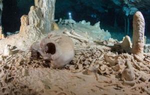
PLOS—Analysis of a skeleton found in the Chan Hol cave near Tulum, Mexico suggests human settlement in the Americas occurred in the late Pleistocene era, according to a study* published August 30, 2017 in the open-access journal PLOS ONE by Wolfgang Stinnesbeck from Universität Heidelberg, Germany, and colleagues.
Scientists have long debated about when humans first settled in the Americas. While osteological evidence of early settlers is fragmentary, researchers have previously discovered and dated well-preserved prehistoric human skeletons in caves in Tulum in Southern Mexico.
To learn more about America’s early settlers, Stinnesbeck and colleagues examined human skeletal remains found in the Chan Hol cave near Tulum. The researchers dated the skeleton by analyzing the Uranium, Carbon and Oxygen isotopes found in its bones and in the stalagmite which had grown through its pelvic bone.
The researchers’ isotopic analysis dated the skeleton to ~13 k BP, or approximately 13,000 years before present. This finding suggests that the Chan Hol cave was accessed during the late Pleistocene, providing one of the oldest examples of a human settler in the Americas. While the researchers acknowledge that changes in climate over time may have influenced the dating of the skeleton, future research could potentially disentangle how climate impacted the Chan Hol archaeological record.
________________________________
A prehistoric human skeleton in the Chan Hol Cave near Tulúm on the Yucatán peninsula prior to looting by unknown cave divers. Credit: Tom Poole, Liquid Junge Lab
Receive 30 days free access to the popular new CuriosityStream lineup of documentaries on science, history, nature, and technology as a new Popular Archaeology premium subscriber.
This richly illustrated issue includes the following stories: Recent findings shedding new light on the whereabouts of the remains of Philip of Macedon, father of Alexander the Great; how an archaeologist-sculptor is bringing bones of the dead back to life; archaeologists uncovering town life at the dawn of civilization; an exclusive interview with internationally acclaimed archaeologist James M. Adovasio about what makes the Meadowcroft Rockshelter prominent in the ongoing search for the first Americans; what archaeologists are finding at the site of the ancient city of Gath, the home town of the biblical Philistine giant, Goliath; and how scientists are redrawing the picture of human evolution in Europe. Find it on Amazon.com.
PROCEEDINGS OF THE NATIONAL ACADEMY OF SCIENCES—Researchers infer urban development in ancient Rome from lead-contaminated sediments of an early harbor. Urban contaminants preserved in sedimentary deposits can offer a historical narrative of economic and industrial development. Hugo Delile and colleagues describe how urban development in ancient Rome can be deduced from lead-contaminated sediments from the city’s first harbor, Ostia. Using high-resolution geochemical and isotopic analyses and radiocarbon dating of a sediment core from Ostia harbor, the authors found that lead pipes used in the aquatic infrastructure of Rome and Ostia were likely the source of lead contamination in the sediment sample. Based on the analyses, the authors stratified the core into three main sedimentary units—pre-harbor, harbor, and post-harbor—that described urban development of Rome’s water system, ranging from the system’s initial expansion to its peak during the early-high Imperial period, around 1st century AD. The authors dated the installation of ancient Rome’s lead pipe system to around 2nd century BC, approximately a century and half after the introduction of Rome’s aqueduct system. Together with the sample from Ostia, a sedimentary core analyzed from Portus, a nearby entry port constructed during 1st and 2nd centuries AD, indicated a reduction in lead levels during the Imperial period that corresponded to the contraction of Rome’s water system. According to the authors, the findings might help fill gaps in the history of ancient Rome’s hydraulic infrastructure.
______________________________________
The Via Gherardo in the ancient Roman port of Ostia. Rabax63, Wikimedia Commons
Receive 30 days free access to the popular new CuriosityStream lineup of documentaries on science, history, nature, and technology as a new Popular Archaeology premium subscriber.
This richly illustrated issue includes the following stories: Recent findings shedding new light on the whereabouts of the remains of Philip of Macedon, father of Alexander the Great; how an archaeologist-sculptor is bringing bones of the dead back to life; archaeologists uncovering town life at the dawn of civilization; an exclusive interview with internationally acclaimed archaeologist James M. Adovasio about what makes the Meadowcroft Rockshelter prominent in the ongoing search for the first Americans; what archaeologists are finding at the site of the ancient city of Gath, the home town of the biblical Philistine giant, Goliath; and how scientists are redrawing the picture of human evolution in Europe. Find it on Amazon.com.
UNIVERSITY OF SOUTH FLORIDA (USF HEALTH)—Chemical analysis conducted on ancient pottery could dramatically predate the commencement of winemaking in Italy. A large storage jar from the Copper Age (early 4th millennium BC) tests positive for wine.
This finding published in Microchemical Journal is significant as it’s the earliest discovery of wine residue in the entire prehistory of the Italian peninsula. Traditionally, it’s been believed wine growing and wine production developed in Italy in the Middle Bronze Age (1300-1100 B.C.) as attested just by the retrieval of seeds, providing a new perspective on the economy of that ancient society.
Lead author Davide Tanasi, PhD, University of South Florida in Tampa conducted chemical analysis of residue on unglazed pottery found at the Copper Age site of Monte Kronio in Agrigento, located off the southwest coast of Sicily. He and his team determined the residue contains tartaric acid and its sodium salt, which occur naturally in grapes and in the winemaking process.
It’s very rare to determine the composition of such residue as it requires the ancient pottery to be excavated intact. The study’s authors are now trying to determine whether the wine was red or white.
_____________________________________
Chemical analysis on these storage jars mark the earliest discovery of wine residue in the entire prehistory of the Italian peninsula. Credit: Dr. Davide Tanasi, University of South Florida
Receive 30 days free access to the popular new CuriosityStream lineup of documentaries on science, history, nature, and technology as a new Popular Archaeology premium subscriber.
This richly illustrated issue includes the following stories: Recent findings shedding new light on the whereabouts of the remains of Philip of Macedon, father of Alexander the Great; how an archaeologist-sculptor is bringing bones of the dead back to life; archaeologists uncovering town life at the dawn of civilization; an exclusive interview with internationally acclaimed archaeologist James M. Adovasio about what makes the Meadowcroft Rockshelter prominent in the ongoing search for the first Americans; what archaeologists are finding at the site of the ancient city of Gath, the home town of the biblical Philistine giant, Goliath; and how scientists are redrawing the picture of human evolution in Europe. Find it on Amazon.com.
UNIVERSITY OF NEW SOUTH WALES—UNSW Sydney scientists have discovered the purpose of a famous 3700-year old Babylonian clay tablet, revealing it is the world’s oldest and most accurate trigonometric table, possibly used by ancient mathematical scribes to calculate how to construct palaces and temples and build canals.
The new research shows the Babylonians beat the Greeks to the invention of trigonometry – the study of triangles – by more than 1000 years, and reveals an ancient mathematical sophistication that had been hidden until now.
Known as Plimpton 322, the small tablet was discovered in the early 1900s in what is now southern Iraq by archaeologist, academic, diplomat and antiquities dealer Edgar Banks, the person on whom the fictional character Indiana Jones was based.
It has four columns and 15 rows of numbers written on it in the cuneiform script of the time using a base 60, or sexagesimal, system.
“Plimpton 322 has puzzled mathematicians for more than 70 years, since it was realised it contains a special pattern of numbers called Pythagorean triples,” says Dr Daniel Mansfield of the School of Mathematics and Statistics in the UNSW Faculty of Science.
“The huge mystery, until now, was its purpose – why the ancient scribes carried out the complex task of generating and sorting the numbers on the tablet.
“Our research reveals that Plimpton 322 describes the shapes of right-angle triangles using a novel kind of trigonometry based on ratios, not angles and circles. It is a fascinating mathematical work that demonstrates undoubted genius.
“The tablet not only contains the world’s oldest trigonometric table; it is also the only completely accurate trigonometric table, because of the very different Babylonian approach to arithmetic and geometry.
“This means it has great relevance for our modern world. Babylonian mathematics may have been out of fashion for more than 3000 years, but it has possible practical applications in surveying, computer graphics and education.
“This is a rare example of the ancient world teaching us something new,” he says.
The new study by Dr Mansfield and UNSW Associate Professor Norman Wildberger is published in Historia Mathematica, the official journal of the International Commission on the History of Mathematics.
A trigonometric table allows you to use one known ratio of the sides of a right-angle triangle to determine the other two unknown ratios.
The Greek astronomer Hipparchus, who lived about 120 years BC, has long been regarded as the father of trigonometry, with his “table of chords” on a circle considered the oldest trigonometric table.
“Plimpton 322 predates Hipparchus by more than 1000 years,” says Dr Wildberger. “It opens up new possibilities not just for modern mathematics research, but also for mathematics education. With Plimpton 322 we see a simpler, more accurate trigonometry that has clear advantages over our own.”
“A treasure-trove of Babylonian tablets exists, but only a fraction of them have been studied yet. The mathematical world is only waking up to the fact that this ancient but very sophisticated mathematical culture has much to teach us.”
Dr Mansfield read about Plimpton 322 by chance when preparing material for first year mathematics students at UNSW. He and Dr Wildberger decided to study Babylonian mathematics and examine the different historical interpretations of the tablet’s meaning after realizing that it had parallels with the rational trigonometry of Dr Wildberger’s book Divine Proportions: Rational Trigonometry to Universal Geometry.
The 15 rows on the tablet describe a sequence of 15 right-angle triangles, which are steadily decreasing in inclination.
The left-hand edge of the tablet is broken and the UNSW researchers build on previous research to present new mathematical evidence that there were originally 6 columns and that the tablet was meant to be completed with 38 rows.
They also demonstrate how the ancient scribes, who used a base 60 numerical arithmetic similar to our time clock, rather than the base 10 number system we use, could have generated the numbers on the tablet using their mathematical techniques.
The UNSW Science mathematicians also provide evidence that discounts the widely-accepted view that the tablet was simply a teacher’s aid for checking students’ solutions of quadratic problems.
“Plimpton 322 was a powerful tool that could have been used for surveying fields or making architectural calculations to build palaces, temples or step pyramids,” says Dr Mansfield.
The tablet, which is thought to have come from the ancient Sumerian city of Larsa, has been dated to between 1822 and 1762 BC. It is now in the Rare Book and Manuscript Library at Columbia University in New York.
A Pythagorean triple consists of three, positive whole numbers a, b and c such that a2 + b2 = c2. The integers 3, 4 and 5 are a well-known example of a Pythagorean triple, but the values on Plimpton 322 are often considerably larger with, for example, the first row referencing the triple 119, 120 and 169.
The name is derived from Pythagoras’ theorem of right-angle triangles which states that the square of the hypotenuse (the diagonal side opposite the right angle) is the sum of the squares of the other two sides.
____________________________________________
The 3,700-year-old Babylonian tablet Plimpton 322 at the Rare Book and Manuscript Library at Columbia University in New York. Credit: UNSW/Andrew Kelly
UNSW Sydney scientist Dr. Daniel Mansfield with the 3,700-year-old Babylonian tablet Plimpton 322 at the Rare Book and Manuscript Library at Columbia University in New York. Credit: UNSW/Andrew Kelly
Receive 30 days free access to the popular new CuriosityStream lineup of documentaries on science, history, nature, and technology as a new Popular Archaeology premium subscriber.
This richly illustrated issue includes the following stories: Recent findings shedding new light on the whereabouts of the remains of Philip of Macedon, father of Alexander the Great; how an archaeologist-sculptor is bringing bones of the dead back to life; archaeologists uncovering town life at the dawn of civilization; an exclusive interview with internationally acclaimed archaeologist James M. Adovasio about what makes the Meadowcroft Rockshelter prominent in the ongoing search for the first Americans; what archaeologists are finding at the site of the ancient city of Gath, the home town of the biblical Philistine giant, Goliath; and how scientists are redrawing the picture of human evolution in Europe. Find it on Amazon.com.
DUKE UNIVERSITY—DURHAM, N.C.—The H.L. Hunley, the first combat submarine to sink an enemy ship, also instantly killed its own eight-man crew with the powerful explosive torpedo it carried, according to new research from a Duke University Ph.D. in biomedical engineering.
The Hunley’s first and last combat mission occurred during the Civil War on Feb. 17, 1864, when it sank a 1,200-ton Union warship, the USS Housatonic, outside Charleston Harbor, South Carolina. The Hunley delivered a blast from 135 pounds of black powder below the waterline at the stern of the Housatonic, sinking the Union ship in less than five minutes. Housatonic lost five seamen, but came to rest upright in 30 feet of water, which allowed the remaining crew to be rescued after climbing the rigging and deploying lifeboats.
The fate of the crew of the 40-foot Hunley, however, remained a mystery until 1995, when the submarine was discovered about 300 meters away from the Housatonic’s resting place. Raised in 2000, the submarine is currently undergoing study and conservation in Charleston by a team of Clemson University scientists.
Initially, the discovery of the submarine only seemed to deepen the mystery. The crewmen’s skeletons were found still at their stations along a hand-crank that drove the cigar-shaped craft. They suffered no broken bones, the bilge pumps hadn’t been used and the air hatches were closed. Except for a hole in one conning tower and a small window that may have been broken, the sub was remarkably intact.
Speculation about their deaths has included suffocation and drowning.
But after an exhaustive three-year Duke study that involved repeatedly setting blasts near a scale model, shooting authentic weapons at historically accurate iron plate and doing a lot of math on human respiration and the transmission of blast energy, researcher Rachel Lance, a 2016 Ph.D. graduate of Duke Engineering, says it was a powerful shockwave from the Hunley’s weapon that killed the crew.
In a paper* appearing Aug. 23 in PLOS ONE, Lance calculates the likelihood of immediately fatal lung trauma to be at least 85 percent for each member of the Hunley crew.
The Hunley’s torpedo was not a self-propelled bomb, as we think of them now. Rather, it was a copper keg of gunpowder held ahead and slightly below the Hunley’s bow on a 16-foot pole called a spar. The sub rammed this spar into the enemy ship’s hull and the bomb exploded. The furthest any of the crew was from the blast was about 42 feet.
Lance says the crew died instantly from the force of the explosion travelling through the soft tissues of their bodies, especially their lungs and brains. She says the crippled sub then drifted out on a falling tide and slowly took on water before sinking.
“This is the characteristic trauma of blast victims, they call it ‘blast lung,'” said Lance, who worked as a biomechanist at the U.S. Navy’s base in Panama City, Florida for three years before entering graduate school at Duke. “You have an instant fatality that leaves no marks on the skeletal remains. Unfortunately, the soft tissues that would show us what happened have decomposed in the past hundred years.”
Blast-lung is a phenomenon of something Lance calls “the hot chocolate effect.” The shockwave of the blast would travel about 1500 meters per second in water, and 340 m/sec in air. “When you mix these speeds together in a frothy combination like the human lungs, or hot chocolate, it combines and it ends up making the energy go slower than it would in either one,” thus amplifying the tissue damage. Lance said that when it crossed the lungs of the crewmen, the shockwave was slowed to about 30 m/s.
While a normal blast shockwave travelling in air should last less than 10 milliseconds, Lance calculated that the Hunley crew’s lungs were subjected to 60 milliseconds or more of trauma.
“That creates kind of a worst case scenario for the lungs,” Lance said. Shear forces would tear apart the delicate structures where the blood supply meets the air supply, filling the lungs with blood and killing the crew instantly. It’s likely they also suffered traumatic brain injuries from being so close to such a large blast, Lance added.
Traumatic blast injuries have unfortunately become a familiar part of recent U.S. military history, but “the injuries experienced by soldiers in a Humvee who hit an IED are different because they are injured mostly by shrapnel and the destruction of the vehicle,” Lance said. “In that case, there are shrapnel effects and effects from the damage to the vehicle that cause broken bones and other injuries. But the crew of the Hunley were protected by the hull. It was just the blast wave itself that propagated into the vessel, so their injuries would have been purely in the soft tissues, in the lungs and in the brain.”
The sub’s design was known to be precarious. During development and testing, the Hunley had sunk twice, drowning 13 crewmen including its namesake, Horace L. Hunley, a privateer who had the submarine built from an old ship’s boiler in Alabama in 1863.
Lance says the designers of the powderkeg weapon also may have recognized the dangers of being too close to a blast in water. Her historical research found that they stayed hundreds of yards away from test blasts of devices that were significantly smaller than the bomb that sank the Housatonic.
“Blast travels really far underwater,” Lance said. “If you’re practicing 200 yards away, and then you triple the size of your bomb and put it 16 feet away, you have to be at least aware that there’s a possibility of injury.”
_________________________________
An oil painting by Conrad Wise Chapman, “Submarine Torpedo Boat H.L. Hunley, Dec. 6, 1863.” Credit: Conrad Wise Chapman
_________________________________________
A graphic reconstruction of the eight-man submarine H.L. Hunley as appeared just before its encounter with the Union ship Housatonic, which it sunk. The barrel on the end of the 16-foot spar contains 135 pounds of black powder. Copyright 2017, Michael Crisafulli, used with permission. http://www.vernianera.com/Hunley
_____________________________________________
An x-ray reconstruction of the interior of the H.L.Hunley shows the color coded skeletons of the eight crewmen still at their stations with no broken bones. Credit: Friends of the Hunley
_____________________________________________
Lance’s calculations are based on tests she did with a 6-1/2 foot mild steel scale model of the Hunley she had built for her experiments. Fitted with interior sensors and floated in water, the model sub was subjected to a series of pressurized-air blasts and scaled black powder explosions. For several reasons, her scale-model blasts ended up being somewhat weaker than what the Hunley crew experienced.
Lance’s dissertation research included searching the National Archives in Washington, testing historically accurate sheets of iron, a dive-certified ATF agent expert in explosives, a Civil War reenactor with a working, period-accurate rifle, and a visit to a museum at DuPont’s original black powder mill.
Scholars at Clemson who have been painstakingly removing concretions from the sub’s cramped interior to learn more about its fate have been evaluating several possible explanations: among them, the crew suffocated, they drowned, a ‘lucky shot’ from Housatonic’s small arms fire breached the hull, or shear forces broke a valve and the sub flooded rapidly.
But Lance has tested and ruled out all of those ideas. “All the physical evidence points to the crew taking absolutely no action in response to a flood or loss of air,” she said.
Lance says her evidence points to a very sudden, soft-tissue injury, rather than drowning or suffocation. “If anyone had survived, they may have tried to release the keel ballast weights, set the bilge pumps to pump water, or tried to get out the hatches, but none of these actions were taken,” she writes in her paper, which is part of her dissertation research.
The research was supported by the Josiah Charles Trent Memorial Foundation Endowment Fund at Duke University, the Department of Defense SMART Scholarship Program, the US Army MURI program (U Penn prime – W911NF-10-1-0526) and an Exploratory Research Grant from the Hagley Library’s Center for the History of Business, Technology and Society.
Lance is working on a book about the Hunley and the experiments that were required to solve the mystery.
*”Air Blast Injuries Killed The Crew Of The Submarine H.L. Hunley,” Rachel M. Lance, Lucas Stalcup, Brad Wojtylak, Cameron R. Bass. PLOS ONE, Aug. 23, 2017. DOI: 10.1371/journal.pone.0182244
___________________________________________
Receive 30 days free access to the popular new CuriosityStream lineup of documentaries on science, history, nature, and technology as a new Popular Archaeology premium subscriber.
This richly illustrated issue includes the following stories: Recent findings shedding new light on the whereabouts of the remains of Philip of Macedon, father of Alexander the Great; how an archaeologist-sculptor is bringing bones of the dead back to life; archaeologists uncovering town life at the dawn of civilization; an exclusive interview with internationally acclaimed archaeologist James M. Adovasio about what makes the Meadowcroft Rockshelter prominent in the ongoing search for the first Americans; what archaeologists are finding at the site of the ancient city of Gath, the home town of the biblical Philistine giant, Goliath; and how scientists are redrawing the picture of human evolution in Europe. Find it on Amazon.com.
April 14 — April 26, 2027. Join Popular Archaeology Magazine and EF Go Ahead Tours for the trip of a lifetime to ancient Egypt. See, in person, the most spectacular and iconic sites and treasures of Egypt. Visit the website for more information!
Experience a unique, up-close-and-personal hike among ancient hilltop towns in central Italy. You will walk the sensational countryside of the regions of Umbria and Tuscany, soaking in important sites attesting to the advanced Etruscan civilization, forerunners of the ancient Romans; imposing architectural and cultural remains of Medieval Italy; local food and drink; and perhaps best of all — spectacular scenic views!Join usin this collaborative event for the trip of a lifetime!
WHO WERE THE AEGEANS? The exciting new podcast series exploring the mysteries of the ancient Aegeans, the Bronze Age people who inspired Homer's epic stories of the Iliad and the Odyssey.