
The world contains numerous hidden remnants of ancient civilizations which exist beneath its forested areas, agricultural fields and urban developments.
Archaeological sites which remain undocumented exist because their locations remain difficult to find through conventional detection methods. These sites often require excavation, requiring significant time and financial resources, and restricted sites. Whereas, ground surveys face limitations due to both terrain and visibility conditions.
Archaeological exploration methods have undergone transformation during the recent years because of advancements in technology. Researchers now apply advanced technological equipment to examine geographical areas from above instead of excavation methods and physical examination. Among all, archaeological surveying technology has created fresh pathways which enable researchers to examine human history without performing ground disturbances.
Seeing the Landscape from Above
Archaeologists now examine the entire site from a higher perspective than they would at a normal level. This new perspective allows them to monitor large-scale land changes such as settlement patterns and ancient land routes.
The differences between traditional aerial photography methods and laser-based scanning is the depth of what it can capture.
Photographic methods capture the entire visible surface details, meaning it can only capture the surface level of things. Whereas laser-based methods can sense minute movements in the terrains, which are present but not visible on the surface elements. This helps in the correct analysis and interpretation of the territories, providing better insights into how the ancient population used these territories.
The invention of aerial surveying technology increases its use in combination with other precise research tools.
Cutting Through Vegetation and Time
The archaeological field faces its most significant obstacle when researchers attempt to study areas with heavy plant growth. The combination of forests, jungles, and overgrown landscapes means structures, pathways, and earthworks could remain hidden for hundreds of years. Conventional survey methods used in such locations are unsuccessful due to the inability to uncover hidden objects under vegetation.
The technology of laser-based scanning enables researchers to penetrate plant cover and accurately map ground features. This method enables identification of minor elevation variations which serve as indicators for discovering hidden walls, terraces, and other cultural elements. Furthermore, this enables researchers to locate new research locations without damaging the terrain through excavation.
Aerial LiDAR scanning enables researchers to study landscapes which previously remained untouched. The method shows what’s beyond the earth’s surface, enabling archaeologists to determine how ancient people arranged their natural surroundings.
Moreover, researchers utilize aerial LiDAR archaeology as their primary method to study how humans have interacted with natural environments throughout history.
Drones and Aircraft in Archaeological Mapping
Drones for archaeology are fitted with advanced sensors making it efficient in surveying big areas while keeping risks to a minimum. Their ability to scan large scale sites at a quicker pace makes it more efficient compared to ground methods. Ground surveys, although effective, may prove to be difficult and hazardous, considering that various locations are difficult to access.
Drone surveys are beneficial in remote areas that may be limited to accessibility, because these drones can reach hard-to-reach places. In addition to this, aerial tools offer precise information that can be studied at a later time. This is, therefore, important since it allows the study of archaeological sites over time, enhancing the understanding of the past. The use of aerial tools, combined with geographic information, can enhance the study of past landscapes, improving history understanding.
In this wider context of current technological realities, drone archaeology services may be conceived as a more scalable non-invasive approach.
Discoveries Enabled by Advanced Aerial Scanning
The advanced methods of aerial LiDAR archaeology have uncovered hidden settlements, ancient transportation routes, and extensive landscape changes at multiple locations. The discoveries made here bring forth new knowledge about how ancient societies operated. These studies demonstrate how people organized their communities and interacted with their surroundings in history.
Aerial scanning technology enables researchers to conduct precise evaluations that extend beyond typical claims of exceptional events. This technology lets archaeologists formulate better research questions from patterns that are revealed through discovery. The process of finding archaeological sites transforms into a method for understanding contextual details instead of just searching for sites.
Remote sensing in archaeology benefits archaeological researchers by enabling the examination of additional research areas. Furthermore, it allows archaeologists to examine regions which would remain hidden because of their environmental conditions and logistical challenges.
Remote sensing in archaeology lets researchers link their individual discoveries with larger spatial and environmental patterns which were previously unrecognizable.
Working Alongside Traditional Field Archaeology
Aerial scanning technology does not replace traditional methods of field archaeology. Instead, it acts as an additional part of the process of excavation together with artifact analysis, and on-site observation. This integration improves validation of research results, establishment of cultural backgrounds, and archaeological mapping.
Technological tools combined with field operations results in research work which achieves greater productivity while maintaining research responsibility. This new and improved workflow reduces the need for unnecessary excavation to understand ancient artifacts while protecting delicate archaeological sites. Aerial data helps document and protect cultural heritage sites, while highlighting non-invasive archaeology tools and methods for contemporary research work.
Archaeologists should analyze their findings through extended environmental and spatial contexts instead of studying single artifacts or existing structures. The process of archaeological mapping enables researchers to link single archaeological locations with wider regional trends. In this way, it enhances historical understanding and supports future preservation work of cultural heritage assets.
What This Technology Means for the Future of Archaeology
The increase in non-invasive research methodologies heralds a new trend in the practice of archaeology. Non-invasive archaeology methods are becoming widespread in the era of remote sensing technologies. This adoption improves the coverage of larger areas in a sustainable and environmentally friendly manner.
In the future, archaeological surveying technology will play an even greater role in archaeological exploration. This is because further advancements will help researchers discover archaeological finds while also improving the conservational strategies in this field of research.
Moreover, the continued development of aerial surveying may help further our understanding of the way ancient civilizations interacted with their environments. By untangling the relationship between the natural terrain and human interaction, it may provide a new historical and evolutionary perspective.
Revealing the Past Without Digging
Aerial scanning has transformed archeological research by revealing hidden artifacts without the need of extensive environmental disruptions. The mixture of aerial scanning and conventional methods is helping historians discover new dimensions of history without interfering with the sites.
Ultimately, the worth of such technology is about how it provides new ways of discovering the remains of the past. By bringing innovation along with scholarly analysis, archaeological site discovery is being redefined, especially through the aid of non-invasive archaeology. With the continued advancement of technology, the future of archaeology moves toward a responsible discovery, understanding, and preservation of the past.
____________________________
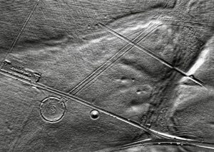
Cover Image, Top Left: A lidar view of Stonehenge. Dr John Wells, CC BY 4.0, Wikimedia Commons
____________________________


