Entire civilizations have been sitting right under our noses for hundreds of years, hidden beneath Guatemala’s dense rainforests and Cambodia’s impenetrable jungle cover. LiDAR archaeology has completely transformed the game when it comes to locating these lost worlds. Using laser-based scanning, this technology digitally peels back layers of vegetation to expose pyramids, sprawling road systems, and massive urban complexes that conventional archaeological methods would never have caught.
The University of Cambridge reports that scientists identified more than 60,000 previously unknown structures in Guatemala’s Maya Biosphere Reserve alone. You’re not looking at a handful of scattered ruins here. We’re talking about entire interconnected metropolitan areas that challenge everything historians believed about ancient civilizations.
Technology Reshaping Archaeological Discovery
The scientific toolkit for hunting down lost cities has evolved dramatically over the last ten years. LiDAR mapping technology works by firing millions of laser pulses at ground level from airborne platforms, then calculating how long each individual beam takes to return.
How LiDAR Mapping Technology Works
Picture this: the equipment launches approximately 150,000 pulses every single second toward the surface below. Some beams smack into treetops and bounce back immediately. Others slip through openings in the canopy and reflect off the actual ground level.
Sophisticated computer algorithms then strip away all the vegetation data, isolating just the bare earth topography beneath. What emerges is basically an X-ray vision of the terrain, revealing every bump, depression, and man-made structure that’s been buried under forest growth for centuries. Today’s systems can cover roughly 50 square miles in just one day.
Ground teams would need years to survey that same area on foot. The vertical precision hits within 4 inches, meaning you can detect incredibly subtle features like ancient farming terraces or protective fortifications.
Many expedition teams now rely on global connectivity solutions powered by esim worldwide services. These solutions operate seamlessly across multiple countries without requiring physical SIM cards. This allows researchers to transmit discoveries and connect with laboratories immediately. As a result, teams can stay connected regardless of how remote their excavation sites may be.
Remote Sensing in Archaeology Applications
Remote sensing in archaeology has expanded far beyond simply locating buildings. You can now track ancient highway systems, water management infrastructure, and even the quarries where construction materials originated. This data shows us how urban centers are linked together and how populations engineered their surroundings.
Here’s something interesting: archaeologists conducting fieldwork in these isolated jungle environments need reliable connectivity for instant data transmission and team coordination. The technology also revolutionizes decision-making about where to actually dig. Resources are limited, you can’t excavate everywhere. LiDAR allows research teams to concentrate their efforts on locations with the highest archaeological potential.
Major Ancient Cities Discovered by LiDAR
The last fifteen years have delivered discoveries that belong in adventure fiction. What really captures the imagination? We’re identifying these locations faster than research teams can properly examine them.
Maya Civilization Breakthroughs
Guatemala’s Petén region has produced the most stunning revelations. Ancient cities discovered by LiDAR include enormous urban complexes linked by raised causeways. The Mirador Basin alone exposed 417 interconnected cities, not simple villages, but genuine urban centers featuring monumental construction.
Researchers discovered Ocomtún in 2023, located in Mexico’s Campeche region. Nobody even knew it existed. The site contained pyramids exceeding 50 feet in height, ball courts, and residential zones extending for miles. Scientists found Valeriana near a contemporary highway in that same area, featuring 6,674 structures, including pyramids and administrative buildings.
These findings indicate that population estimates for the Maya were wildly inaccurate, off by millions. Current research suggests 10-15 million people inhabited the lowlands during the civilization’s zenith, roughly twice what scholars previously calculated.
Southeast Asian Findings
Cambodia’s famous Angkor Wat temple complex? Turns out that was merely scratching the surface. LiDAR mapping exposed over 1,000 square kilometers of concealed infrastructure surrounding those iconic temples, entire neighborhoods, elaborate water control systems, and roadways connecting dozens of temple locations.
The scans demonstrated that Angkor wasn’t some isolated religious sanctuary. It was actually the nucleus of an expansive medieval city. Engineers had constructed ingenious hydraulic networks with reservoirs and channels that regulated water distribution throughout wet and dry seasons.
Impact on Understanding Lost Civilizations
These breakthroughs accomplish more than adding new locations to archaeological maps. They’re fundamentally reshaping our comprehension of how sophisticated societies evolved and ultimately declined.
Population Estimates Transformed
Lost civilizations uncovered by LiDAR repeatedly demonstrate population densities far exceeding what researchers considered feasible. Regions previously classified as sparsely inhabited wetlands actually supported intensive farming operations and substantial settlements.
The Maya lowlands potentially housed 10-15 million inhabitants at peak capacity. That density matches medieval England, except compressed into a tropical jungle landscape. These weren’t struggling primitive groups barely surviving, they were advanced civilizations that flourished across centuries.
Trade Networks Revealed
LiDAR has unveiled extensive highway systems linking urban centers across hundreds of miles. These weren’t simple walking paths but engineered roadways elevated above flood zones, built wide enough for substantial traffic flow.
The ramifications for understanding ancient trade and cultural interaction are enormous. Urban centers that appeared isolated were actually critical nodes in extensive commercial networks.
Wrapping Up the LiDAR Revolution
You’re witnessing a golden age of archaeological discovery that’s literally rewriting ancient history. LiDAR archaeology has demonstrated that civilizations we assumed we understood were actually far more extensive and sophisticated than anyone imagined possible. The technology continues advancing, and future surveys will undoubtedly uncover additional hidden cities across every continent.
Your Questions About LiDAR Archaeology Answered
1. Is LiDAR used in archaeology?
Airborne LiDAR technology maps terrain features and identifies cultural elements hidden beneath vegetation cover, giving archaeologists comprehensive aerial perspectives of complete sites. Ground-based LiDAR generates extremely accurate three-dimensional models of ancient buildings on smaller scales.
2. How accurate is LiDAR for finding ancient structures?
Contemporary LiDAR systems deliver vertical accuracy within 4-6 inches and can identify features as compact as 12 inches across. The technology detects 85-95% of artificial structures, though ground verification is still crucial for validating discoveries.
3. Why are we finding so many cities now?
LiDAR technology has only become financially accessible for large-scale surveys within the past decade. Equipment costing millions in 2010 now runs hundreds of thousands, making comprehensive mapping projects realistic for universities and research organizations.
_____________________________
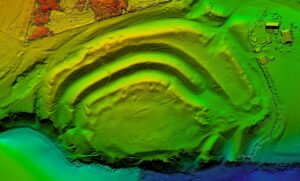
Cover Image, Top Left: Digital terrain model created on the territory of the archeology monument of the fort of Kudin city, 9-13 centuries, Ukraine, Khmelnytsky region, Letychiv district. Panchuk Valentyn, CC BY 4.0, Wikimedia Commons
_____________________________


