The conquest of Perú was not, as the word “conquest” implies, a grandiose affair with drums beating and banners flying. Quite the opposite; it was the unexpected outcome for the search for a way across the isthmus of Panama to the Pacific Ocean from the North Sea, today’s Caribbean Sea. At the time, no one could conceive that a South American continent existed.
The “conquest” started with Vasco Núñez de Balboa (1475-1519), mayor of Santa Maria de la Antigua del Darién, the first permanent European settlement in Panama. He was a deputy to Pedro Arias de Avila, governor of Golden Castille (later referred as Tierra Firme by the Panama’s Royal Academy in 1538), covering Nicaragua to the Bay of Panama. With sixty-seven Spaniards, Balboa left the settlement in Antigua, battling against nature and natives over the jungle-clad Darien mountains, in search of gold, fame, and a way to the South Seas (now known as the Pacific Ocean).
___________________________

Ph.1 – Castilla de Oro, Tierra Firme 1513 @Santos30-wikipedia.com
___________________________
With him was Panquiaco the son of the Caquetá chief, who told him about a rich land that lay further south on the coast, with great kings. He told Balboa of seagoing boats, gold, and pearls; a land the natives called Birú, the name of its king. On September 25, 1513, Balboa stood on a thousand-foot-high peak in the Darien looking spellbound at the immensity of the South Sea, while his second in command, Francisco Pizarro gazed intently for in his mind echoed Panquiaco’s words…great lands…and…gold!..gold! This sketchy rumor laid the seeds of the Spanish conquest of Perú.
Conquistadors were granted a license to explore and conquer by the Spanish Crown in Madrid, stipulating that the venture would not carry any expense to the Crown. All costs were borne by the conquistadors, who had to borrow money and/or provide in-kind guarantees from families in Spain, as the cost of such ventures was high. Conquistadors had to pay for ships, crews, soldiers, weapons, and food; they had to build settlements to explore unknown and dangerous lands and fight endless battles in their ceaseless quest for gold. They had to pay for enlisted soldiers, ship crews, and debts. Many enlistees were paid soldiers released by the Spanish army from the Christian-Muslim War (1481-1492), or the Italian Wars (1494-1559).
An overseer from the Crown, appointed by the House of Trade of the Indies in Seville, was attached to each expedition, keeping detailed logs of goods and transactions. The conquistador paid him, and so he was a chaplain. The “Right of Conquest” was granted as a binding contract, which was predicated on the Crown’s receiving the royal fifth (quinto real) on all imported precious metals. Other taxes, which could run up to 40%, included providing naval protection for returning ships laden with treasure. Once the new territory was settled and pacified, the Crown appointed a vice-roy, governors, officials, and an army chief, while bishops of the Catholic orders assigned priests.
Born out of wedlock in Trujillo, Spain, in 1478, Francisco Pizarro joined the military in his late teens, rising to the rank of lieutenant while fighting in the Italian Wars, where he was wounded. Upon his return to Spain in 1502, Pizarro traveled to the Indies, as the recently discovered territories were known. When in Santo Domingo, on the island of Hispaniola, he was hired as a messenger in the local government. Frustrated in this position, he joined Captain General Alonso de Ojeda as a sub-officer.
With de Ojeda, he fought in the wars against the indigenous Taíno people on the island of Borinquen (today Puerto Rico), rising to second in command when de Ojeda, wounded by a poison-tipped arrow, had to return to Santo Domingo. Pizarro was instructed to wait forty days and, should de Ojeda not return, sail back to Santo Domingo with the soldiers. Pizarro followed de Ojeda’s instructions with a twist. He took two brigantines and sailed west with de Ojeda’s partner, Fernández de Enciso. They landed at the port of Santa Maria la Antigua del Darién (1510), in the estuary of the Tarena River on Panama’s Caribbean coast. There, he met Balboa, also called the “fellow of the drum” for his daring escape from creditors in Santo Domingo, hiding in a wine cask with his dog Leoncito. In Pizarro, Balboa recognized a kindred spirit and made him lieutenant governor.
_______________________________
Ph.2 – Vasco Núñez de Balboa. @georgefery.com
_______________________________
In 1515, Balboa was named second to the governor of Castilla de Oro, Pedro Arias de Ávila (aka Pedrarias Dávila, 1440-1531), his father-in-law. For reasons that would deviate from our narrative, Balboa rebelled against Pedrarias who, after a speedy trial, had him beheaded in the town’s plaza, watching the proceedings hidden behind a curtain. In 1523, Pizarro took over Balboa’s position.
We have little knowledge of Pizarro, but his achievements point to his strong personality, ethical strength, and great determination to overcome hardship and fear. At that time, he was respected as one of the founders and the Mayor of Panama with a large cattle farm in the city’s outskirts. All these years, however, Pianquaco’s words about gold kept nibbling in his mind, so he set to work on a plan for the discovery down the coast of the South Seas. Once the plan was set, he brought in two partners, the military officer Diego de Almagro and the school master Hernando de Luque. The three swore secrecy and sealed the promise with a mass and sacraments in the main church of Panama. The partners agreed that their share of the riches would be split equally. Pizarro would captain the venture, Almagro would be his second in command, while Luque was tasked with defending the trio’s interests with the governor in Panama. The ink was not yet dry when the plan reached Pedrarias Dávila, who demanded to join the group as a silent partner, not to risk his position as governor of Tierra Firme. For his partnership, Pedrarias Dávila invested some money in the venture and provided the mandatory official license for the expedition, which is now called the “Eastern Enterprise” (Empresa del Levante).
On September 13, 1524, the two-masted ship Santiago departed with Francisco Pizarro in command and sailed west to Taboga in the Pearl Islands. His crew of adventurers comprised 112 ex-soldiers, misfits, and a few Nicarao Indians as support hands. Also aboard were a handful of horses and two war dogs. This first attempt did not go well. Beyond the Pearl Islands, the ship sailed south along the South American continent’s coast, fighting headwinds and gales. They stopped at fishing villages that showed no sign of wealth; the crew only found a few gold trinkets and semi-precious stones. They kept sailing south despite hardships and, at times, gnawing hunger. In February or April of 1525, before heading back to Panama, they stopped at what appeared to be the palisade of a fortified village up on a hill near the coast. The Spaniards called it Fortín del Cacique de Las Piedras. That afternoon, they went up through a thick jungle and found the place deserted, so they settled there for the night.
At dawn, war cries awoke the Spaniards who scrambled to face a large group of well-armed half-naked men. The battle was brutal, and the Spaniards fought their way back to the coast while the fearless war dogs saved the day by gutting natives. Fifty Spaniards were seriously wounded, and five were missing and presumed dead. Pizarro headed back to Chochama, his rear base in the Bay of Panama.
_____________________________
Ph.3 – First Forays @J.A. de Busto, 1973
_____________________________
Almagro and the San Cristóbal, another carrack mid-size ship, sailed a week after Pizarro with sixty-four soldiers, support personnel, horses, and war dogs. Like his partner, Almagro followed Pizarro’s southern route along the coast and tried with fifty men to capture Las Piedras, but he had to fall back fighting. Wounded in the face and losing an eye, he was about to be seized by the natives when Juan Roldán, a black free slave, saved him. The soldiers counterattacked and set fire to the stronghold, later called Battle of Punta Quemada. Fighting all the while, Spaniards moved back to the San Cristóbal with their wounded captain. They sailed to the Pearl Islands in the Gulf of Panama, and then to Chochama where Almagro joined Pizarro.
Both agreed that this first foray into the unknown did not produce much but sent the few pieces of gold they had found to Pedrarias Dávila in Panama City, who became furious upon learning of the poor returns on his investment. He called Pizarro an inept fool and other disrespectful names. He declared Birú a land of misery and threatened to fold the Eastern Enterprise and leave for Nicaragua to attend to Spanish settlers. Over the following days, Hernando de Luque informed Pedrarias Dávila about staying in the partnership, which he did with the condition that Pizarro be assigned second-in-command. Almagro welcomed this task to avoid the possibility of a fifth partner joining the venture.
_____________________________
Ph.4 – Pedro Arias de Ávila @silverreaderclub.com
_____________________________
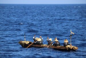
The argument was settled and Pedrarias Dávila agreed to try another six-month voyage. Should that foray fail to produce results, however, the “Eastern Enterprise” would be terminated. On this second sailing, Luque grasped the opportunity to join Pizarro and Almagro. With good winds, in early February 1526, Pizarro and Almagro sailed again, each in command of one of the two manned and provisioned ships of the first voyage, together with three lighter support crafts. They were guided by the master pilot Bartolomé Ruiz de Estrada, who ran on the last route. Cruising south they stopped at Las Piedras and in anger killed every soul and burned the place again. On their way they anchored for water at Isla de las Palmas where in a brief skirmish with locals, two Spaniards were wounded. The men kept sailing south in heavy sea, and at the end of August 1526, along a river they would name San Juan, they assaulted villages to retrieve gold and silver artifacts. The country inland, however, was poor and hilly. Pizarro sent Almagro back to Panama with instructions to enlist more men, while the pilot Ruiz de Estrada was instructed to head south and explore the coast. At the same time, Pizarro and soldiers on horseback followed the ship’s track on land while exploring villages and coves. On his map, Estrada noted the mouth of several rivers with waters coming from the Andes Mountains seen far inland. For the first time, off the cape they called Cabo Pasado, they crossed the austral equinox line and, a couple of days later, off the island of Salango, they met five large outrigger boats with a sail and large paddle-rudders. Frightened by the foreigners, the crews jumped into the sea and swam to the coast. On one of the boats, however, the local trader and his crew of one man and three boys remained. They showed their loads of fine black and cream-colored ceramic bowls and plates and woven blankets of fine alpaca wool. These goods alluded to a cultured society.
The boats’ crew spoke a dialect used in a town the Spaniards would later learn was Tumbes, located further south on the coast. Pizarro took the boys and named them Felipillo, Yacané and Martinillo, for their actual names could not be translated, and ordered the ship chaplain to teach them Spanish. Pizarro wanted to continue further down the coast, but his crew rebelled because, after months at sea, they wanted to return home; anger almost led to blows.
When Almagro returned from Panama with more men, horses, and food, he brought news that Pedrarias Dávila had been replaced as governor of Tierra Firme by Pedro de los Ríos. Pizarro kept sailing south, and toward the end of July 1527, came to a river named Santiago. The most lucrative encounter occurred close to Isla de Salango’s Punta Illote, a spot they will later call Cabo de la Vuelta, marking the point where they headed back north to answer the crew’s pressing demands to return home. Tired of their complaints, Pizarro ordered the captain to head north to a forested hilly island they called Isla de Gallo. He claimed that the ship’s hull needed cleaning, so the ship had to be beached. Once the work was done, the crew believed they would be returning home. Then in mid-September two white sails appeared on the horizon.
Pizarro thought that more people and support were coming. Instead, captains Juan Tafur and Pedro de los Ríos landed on the beach with the service boat with orders from Panama’s governor for everyone to return. Tafur sternly demanded that Pizarro and Almagro promptly sail back with all their men. After a tense and bitter exchange, the men came close to settling the argument with their swords. As recorded by eyewitnesses, Pizarro then traced a line in the sand and said: “On this side are those who want to return to Panama and be poor; on my side, those who will remain with me and be rich; your call!” Thirteen crossed over the line, as did the pilot Ruíz de Estrada, even though he had pleaded earlier with Pizarro to return for family reasons. After six months having been left stranded by Tafur, who had returned to Panama with the remaining crew, fighting hunger, torrential rains, mosquitoes, and fever, in March 1528, another sail on the horizon signaled the arrival of a ship from the north, with instructions from the Panama governor to return to Panama. Pizarro again refused, and the partners convinced Ruìz to keep sailing south against the winds and storms of the season. After two weeks, they landed on an island they called Isla de Santa Clara, where they found offerings of finely painted ceramics, fine embroidered textiles, and many large gold and silver disks at the feet of a large stone idol.
The following day, five ocean-going native outrigger boats appeared. They were from the same community as those they had met the year before. They were tumbesinos warriors who led them a few miles south, to a large town called Tumbes, which was protected by a stone wall and a fortress built of massive quadrangular stones. The town’s chief Chilimaza sent men to greet the foreigners. The envoys were kurakas, Quechua-speaking magistrates assigned to large towns by the Great Inca in Cusco. As a welcome, the tumbesinos offered them food, water, and three llamas, which the Spaniards thought were camels without humps. Pizarro was invited to visit the city, but wary of treachery, sent the Greek Pedro de Candia, two musketeers, a mounted horseman, a war dog, and gifts of animals then unknown in Perú: two live pigs, five chickens, and a rooster. Reports from the visit were that the city was well built of stone and its streets clean and paved. Buildings and temples, such as a monastery for the virgins dedicated to the Sun, were likewise well built with carefully shaped stones. People were finely dressed in leather sandals, while markets were well provided with all types of fruits and vegetables.
Pizarro left Tumbes without getting into the town, with thanks and the promise of return (which he did in 1532 on his third expedition, when he battled and defeated chief Chilimaza). The Spaniards kept sailing south and found an island they called Isla de los Lobos on the Paita coast, eventually landing in a cove they named Malabrigo. There, they learned that one of the crew, Bocanegra, had deserted and remained with the Indians. On May 3, 1528, the ship headed back to Panama.
Pizarro’s arrival was the most significant event since the city’s foundation. Everybody gathered at the port to see the gold and silver, the colorful fabrics, the ceramics, and the horse-like animals (llamas). The crew members who had returned with Tafur bitterly deplored their lack of resolve. The name Perú, instead of Birú, was officially recognized and spread from mouth to mouth and from streets to taverns. The “Eastern Enterprise” was renamed the “Perú Enterprise.” Not so happy was Governor Pedro de los Rìos, for he was concerned that should many people leave for the new land, it would depopulate the government of Tierra Firme.
The partners realized they needed their discovery to be recognized by the Crown in Madrid. After arguing about the terms of a potential contract, they agreed that Pizarro should go to Spain, where he would ask for titles for each of them: governor of Perú, for Pizarro; “adelantado” or military commander, for Almagro; and the bishopric of Tumbes for Luque. Ruiz de Estrada would get the title of “alguacil mayor,” an ancient title meaning bailiff and a high office charge. The thirteen crew members of the last expedition would receive bonuses in addition to paid functions.
In early September 1528, when all was agreed, Pizarro boarded a ship from the port of Nombre de Dios on Tierra Firme’s Caribbean coast. With him were the young boys Felipillo, Yacané and Martinillo whom he had captured off the Island of Salango; the ship also carried half a dozen llamas, fine painted ceramics and embroideries, and much gold and silver. Pizarro landed at the Spanish port of Sanlúcar and went on to Seville. There, the lawyer Martin Fernández de Enciso recognized Pizarro as Alonso de Ojeda’s former lieutenant, accused him of having connived with Pedrarias Dávila in Balboa’s trial and execution, and demanded that he be jailed.
Someone at Court in Madrid, probably Pizarro’s brother Hernán demanded, through the Council’s office, that he be released on grounds of unsustainable facts and falsehood. In Madrid, Pizarro met with members of the Royal Supreme Council of the Indies, where he presented his written accounts and the maps of his voyages of discovery to Queen Isabela.I (1451-1504). He presented the tumbesinos Felipillo, Yacané, Martinillo and showed the llamas, the finely embroidered fabrics, and the gold and silver. The Royal Council was stunned by the news of this unknown world, which they named Nueva Castilla. A formal agreement was created, granting Pizarro the titles of Captain General, Governor, Administrator, and Constable over New Castille’s 200 leagues (700 miles). This area would henceforth be called Perú. Pizarro would receive an annual remittance of 725,000 gold maravedis (+/-$240K); Almagro was named Mayor and Constable of Tumbes, renamed Nueva Valencia de la Mar del Sur, with 300,000 maravedis and the honorific title of “hidalgo” or gentleman; Bartolomé Ruiz was named first navigator of the South Seas with 60,000 maravedis; Pedro de Candia was elevated to the rank of artillery major of Perú and councilor of Tumbes, while the thirteen sailors were granted the status of knights of the Golden Spur with related benefits.
___________________________
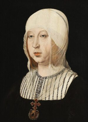
Ph.5 – Queen Isabela.I of Castille @wikipedia.com
___________________________
Under the terms of the agreement, Pizarro was authorized to set up towns with good soil and clear running water to grow food; name town mayors; mine gold and silver; build forts and organize military forces of 250 men; import horses and slaves; protect and evangelize the natives. Queen Isabela.I signed this Capitulación de Toledo or Agreement of Toledo, on 6 of July 1529. Once the nominations and agreement were signed, Pizarro, now with the title of governor of Perú rode to Trujillo, his birthplace in the province of Extremadura. He enjoyed his extended family there for a few weeks, many of whom would follow him to the New World. They included his illegitimate brothers Juan and Gonzalo Pizarro, a half-brother, Francisco Martín de Alcántara, and several childhood friends. In early 1530, they all met in Seville with Crown officials assigned to follow Pizarro, who planned to sail from the port of Sanlúcar de Barameda, instead of the traditional port of Cádiz. His last-minute port change was to bypass the terms of his agreement and exit license, which required him to take 250 soldiers.
Pizarro’s brother Hernando smartly suggested that, with his family and friends, the number of men met the exit license requirements. Meanwhile, the partners in Panama, Almagro and Luque, anxiously awaited Pizarro’s arrival in Nombre de Dios. Almagro was angry because, in past correspondences, he believed that his partner had hoarded Perú’s three most important Crown titles. He was enraged that he wanted to break the “Perú Enterprise.” Luque told him that there had to be reasons that would be explained upon their partner’s arrival. Almagro tepidly welcomed Pizarro, who, perceiving his partner’s antagonism, told him that he had to accept the three titles because the Crown did not want to split the agreement between two or more holders. Therefore, he had to bow to the Crown’s demands or lose the deal. Pizarro then underlined that the “Perú Enterprise” terms of association of equal partnership remained unchanged. Almagro was mollified, and the partners started to organize the third expedition to Perú. As expected, arguments quickly arose between Almagro and Pizarro’s brothers, Juan, González, and Hernando, with whom Almagro never got along. The antagonism was again threatening to break the enterprise, but thanks to Pizarro’s authority and Luque’s conciliatory approach, Almagro remained.
In the following weeks, two ships arrived from Nicaragua loaded with Indian slaves, under the command of Juan Ponce de Leon and his partner Captain Hernando de Soto. For his support in the Perú venture, de Soto demanded the position of lieutenant governor. He further demanded, for Ponce de León discoverer of Florida (1513), a large portion of land with natives to conquer. Once Pizarro, Almagro, Luque and the others agreed on the terms of their association, they prepared the third expedition.
On December 27, 1530, the flags were blessed in Panama’s main church. The following day, Pizarro called for sailing within the next few weeks, and on January 20, 1531, they sailed to the Pearl Islands and then headed south with a good sea and winds. Besides its crew, there were 180 soldiers, support personnel, 36 horses, and war dogs. The second ship under Captain Cristóbal de Mena’s command was ordered to follow in early February.
Pizarro and his army landed on February 17 in a bay called San Mateo. While the second ship sailed further south, Pizarro, on horseback, accompanied by riders, headed inland along the coast. They entered the town of Atacames, where locals wore fine dresses. In the fishing town of Cancebi they met nobles wearing jewels of gold and saw precious ceramics and fishing nets. Tired, hungry, and under clouds of mosquitoes, they crossed the Quiximes Delta and, battling Coaque natives, found more gold and emeralds. Still heading south, and suffering from painful warts that crippled many, they stopped at a small village where they stayed from April 19 to September 11 to recover. In mid-September, a boat from Nicaragua arrived with reinforcements. The captain, Sebastián de Belalcázar, agreed to bring his men to join Pizarro’s troops, together with two of his friends, on condition that one be named aide-de-camp to Pizarro and the other the town’s mayor. With his sick army, Pizarro had no choice but to agree to the demands. With reinforcement, he proceeded south on a desert-like landscape of vast arid and sandy coastal plains interspaced by valleys and rivers of low water flow, seasonally fed by the snow melts from the snow melts of the Andes mountains.
In early October, after passing through Anta, Odon, and other small towns, and a place named Punta de Santa Elena, Pizarro rested his tired, thirsty, and hungry troopers. On Christmas Day of 1531, they met the Puna Island’s chief, Tumbalá, who brought them water and food, and invited them to visit his island. From past experiences of natives’ tricks hidden by smiles, Pizarro insisted he would only board the boat with the local chief, who was taken aback but accepted.
_________________________
At this point, it is suitable to clarify who the people of Perú were in the sixteenth century. Today, the country is home to fifty-eight indigenous groups speaking forty-seven languages. The largest is Quechua, with Aymara being a second, but essential, group, which together make up about a quarter of the country’s indigenous population. When the Spaniards arrived in the sixteenth century, there were more ethnic groups, each with their dialect, beliefs, customs, and antagonisms. Quechua was spoken in the kingdom’s capital, Cusco, called “Land of Four Parts” or Tahuantinsuyo. It spanned a territory from today’s Ecuador to most of the northern part of Chile and the northwestern part of Argentina in the south. This mosaic of cultures and languages strained under the Incas’ iron-fisted authority, which fueled sporadic rebellions.
Pizarro understood the latent antagonisms but did not realize then the immensity, complexity, and cultural fragmentation of the Inca empire. His persistent distrust of unknown people was grounded in his experiences in sixteenth-century European wars, where defiance was the norm. On Puna Island, captive young men from other tribes confirmed his suspicions. Pizarro learned about an agreement between recent enemies, Tumbalá of Puna and Chilimaza of Tumbes. The latter had secretly arrived at night with warriors to capture or kill the white-bearded men, who fought back savagely for their lives. The Spaniards were saved by the arrival of two ships and soldiers under the command of Hernando de Soto, who turned the tide.
___________________________
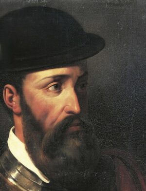
Ph.6 – Francisco Pizarro @wikipedia.com
___________________________
The “war of succession” that had gone on in the mountains over the last few years indirectly affected the people of the coast, but they knew what was happening from families and friends. Inca officials seconded the chiefs of towns and cities to assist them in administering and overseeing the local political order. That is why it was found later that the Inca governor of Tumbes knew about Tumbalá and Chilimaza’s deep-seated antagonism. Under threat from the Inca, they were forced to cooperate and capture or kill the Europeans, who were unaware of the raging war in the country. In April 1532, with de Soto in Chilimaza’s light boats, the Spaniards boarded their ship and left the island, which they had renamed Isla de Santiago. They then sailed to Tumbes on the coast and left that city on May 16 of that year, leaving behind a squadron of soldiers, a Crown official and a priest. A week later, Pizarro and his men reached the town of Poechos, where its chief Maizavilca welcomed them. Over a few weeks, Pizarro informed him of his plan to build a city and a port on the coast a few leagues away at the mouth of the Río Chíra. This plan alienated the chief’s welcome because he realized that he would lose authority. Like other chiefdoms in the region, however, he wanted to shake off the heavy hand of the Sapa Inca in his affairs but realized that he might have welcomed a heavier hand that would weaken his kinglet powers. Maizavilca shared his concerns with other principals of townships in the Río Chira’s Valley, who agreed to persuade Pizarro to move up the mountains, where bigger prizes and gold awaited. The Indian chiefs’ double aim was to get the Spaniards out of their lands and hand them over to Inca Atahualpa’s army, encamped near Cajamarca, nine thousand feet up in the Andes Mountain range.
The Inca was informed of the progress of Pizarro’s army on the coast and sent a spy to ascertain that they were men and not, as Maizavilaca claimed, huiracochas, the messengers of Huiracocha, the foremost god in the Inca religious pantheon. The spy met Hernando Pizarro and understood he was Francisco Pizarro’s brother. He was fascinated by the barber who shaved men’s faces, and the tamer who, at will, managed horses and war dogs. He also found out that horses only ate grass, not meat, while war dogs ate meat, not grass. His most significant discovery was that the Spaniards were men, not huiracochas, and he reported his findings to the Inca Atahualpa, who understood Maizavilca’s duplicity and kept it in mind for later retribution.
______________________________
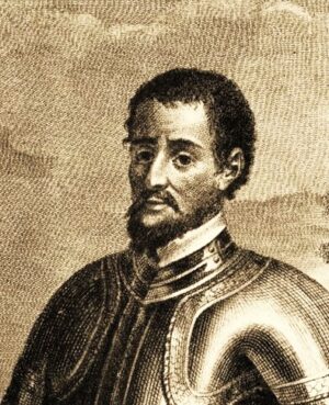
Ph.7 – Hernando de Soto @wikipedia.com
______________________________
Pizarro was still focused on building a town to settle European migrants. So, on July 15, 1532, he built the village of Tangarará on a promontory South of Poechos in the delta of Rio Chira, whose shores were covered with trees and grass. It will not be his last attempt at a permanent settlement. Pizarro’s thirst for gold had not dimmed despite his venture’s trials, hardships, and growing costs. At that time, he knew the riches were not on the coast but up the mountains in Cusco, where he said the city was covered with gold.
Persistent rumors by natives about war up in the mountains would not stop him. He promised the rope to warn would-be deserters in his crew, demanding to return to Tierra Firme. Unbeknownst to the Spaniards, over the last two years, the war of succession for the crown of the Tahuantinsuyo or “Land of Four Parts” had raged between Huayna Capac Inca Yupanqui’s two sons, Atahualpa and Huascar. This tragic chapter of Perú’s history will be narrated in the next installment, “The Fall of Cusco.”
_______________________________
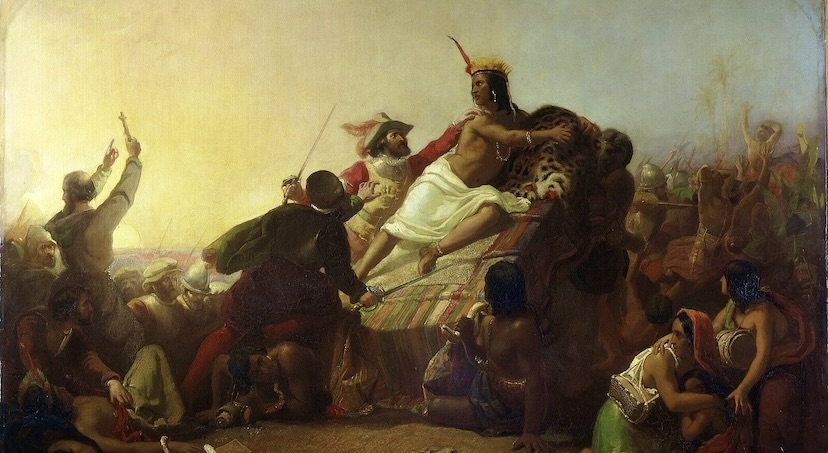
Cover Image, Top Left: Pizarro and the Inca of Peru, Public Domain, Wikimedia Commons