It all began some twenty-five years ago in the boiling-hot and humid basin of Kopais, a drained marshland in the region of Boeotia in Greece. In July of 1990, already a first-year graduate student at the University of Pennsylvania, I was working as a sector supervisor at the archaeological excavation of the Mycenaean citadel of Glas under the direction of my mentor, the late Sp. Iakovidis. At the time, our work focused on the east wing (C) in the area of the so-called “Agora,” the largest of three central enclosures that were protected by the cyclopean fortification walls of the citadel. The finds were astonishing: my team was unearthing a long storage building with ramps (K), which was filled with a thick destruction layer of burnt soil and crops, and residential quarters (M) that yielded frescoes, bronze pivot sockets, the first (and so far the only) seal stone ever found at Glas, and pottery dating the destruction (advanced LH III B2 – ca. 1220 BC). During intervals and occasionally in the afternoons I would walk the site with the other sector supervisor, my friend Dimitris Chaniotis, an archaeologist of the Department of Underwater Antiquities: it made no sense to either of us that two thirds of the vast area of the citadel (ten times the size of Tiryns and seven times that of Mycenae) would have been left void of any structures, as Iakovidis believed and published it, or that three kilometers of massive cyclopean walls would have been built to protect empty space. The site was literally covered with Mycenaean pottery sherds and at places wall corners were partly emerging from the soil, as also noted by R.H. Simpson in his plans and descriptions of the citadel (Mycenaean Greece, 1982). We promised ourselves that one day we would return to the site to further explore it. Dimitris never made it – he died young after a routine dive.
Almost twenty years later, while I was excavating the newly discovered Lower Town of Mycenae under the direction of Iakovidis, I made up my mind to pursue my long-standing goal. The last weekend of July 2009, I drove back to Athens to chat with Iakovidis. After having a cup of coffee at his apartment in the city, I posed the critical question: would he object to a re-investigation of Glas so long after his final publication of the site? At first, he tried to discourage me: the rest of the citadel was most probably empty; it would be a certain waste of funds, time and energy; and in any case, I had more important work to do at Mycenae with him, he said. I disagreed, remarking rather audaciously that he did not believe that there was a Lower Town at Mycenae either, which we did find after all. I promised that I would continue excavating and publishing at Mycenae with him ceaselessly as I had done for the past twenty years, and reminded him that at my age he was conducting not two, but three excavations at a time. He paused and stared at me enigmatically; if there were anything else to be discovered at Glas, I added, who else had better find it, if not his own protégé? He then smiled and nodded affirmatively. One year later, he was impatiently pacing in the hall of the McCarthy House at Mycenae in anticipation of my preliminary survey results; I still remember vividly his astonishment when I unfolded the new map of Glas before his eyes…
_________________________________
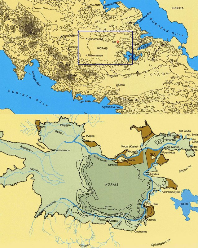 Maps illustrating locations of Boeotia and Kopais
___________________________
Location
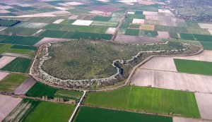
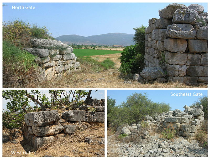
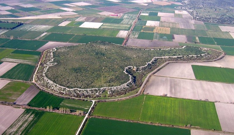 A vast citadel, today known as “Gla(s)” or “Kastro” (castle), was built on top of an island-like, flat-topped bedrock outcrop rising 9.5-38 m above the plain below and encompassing an area of 20 ha or 49.5 acres or 200,000 square meters at the northeastern edge of the Kopais basin. The Mycenaean citadel of Glas was fortified by a massive cyclopean wall (5.50-5.80 m thick), which runs along the brow of the rocky natural platform for approximately 3 km, features four gates (including one double gate), and encompasses a cluster of three adjacent and intercommunicating central enclosures.
______________________________
General plan of the Glas site
__________________________________________
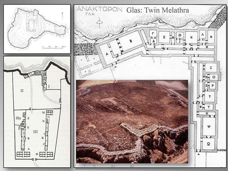
The northern enclosure (II) (3.7 acres or 1.5 ha) surrounds an administrative and residential complex with two ‘twin’ long wings built at an angle on the summit of the rocky hill. Either wing contains a focal, single-storey megaron-like room (melathron) at its remote end, which was richly decorated with frescoes but lacks a throne or a fixed central hearth surrounded by interior columns. Both wings also contain several two-storey residential apartments communicating through two long corridors and a central staircase. The southern enclosure (III) (12.6 acres or 5.1 ha) encompasses two parallel, long (ca. 150 m.) storage buildings with a total capacity of ca. 2,000-2,500 metric tonnes, which were divided internally by cross-walls and were equipped with wide access ramps; other attached subsidiary rooms used as guard houses, personnel residential quarters, workshops, and kitchens (comprising totally ca. 660 sq. m.) were arranged quite symmetrically north and south of the storage facilities and were often decorated with frescoes (several rooms in E, Z, M, N, but also in A, H). The southern enclosure is connected with the south gate of the citadel via a road running through a central propylon on its southern peribolos wall, while another road connects the northern enclosure with the north gate of the citadel through a propylon on its eastern peribolos wall; the two adjacent enclosures communicate through a guarded internal gate. Another smaller enclosure is formed immediately east of the northern enclosure without any apparent entrance or visible ruins (I). Finally, an internal cross-wall running from the central tower of the southeast double gate to the north cyclopean wall separates and isolates the eastern sector of the citadel which was, thus, accessible only from the eastern entrance of the double gate (IV).
But what was the purpose of this vast Mycenaean citadel and how did it relate to its surrounding landscape? The Mycenaean palatial economy required specialized agricultural production to meet basic needs of a fast growing population and to afford surplus for exportation. However, the indigenous environmental circumscription and resource limitations of the Greek mainland eventually necessitated expansion and intensification of such surplus-geared specialized agricultural production. In the closing years of the 14th century BC (LH IIIA2) a large-scale engineering project of gigantic proportions was realized in Boeotia, perhaps a joint venture of the neighboring palaces of Thebes and Orchomenos, which effectively transformed the Kopais basin (ca. 20,000 ha) into the most fertile plain on mainland Greece: the submerged marshland was artificially drained by means of an ingenious and complex drainage control system which involved course diversion of six rivers and streams (Kephissos, Melas, Herkyna flowing from the west, Phalaros, Triton, Lophis on the south) from the basin into two wide peripheral canals, the North and the South Canal. These artificial and possibly navigable canals converged in the northeastern edge of the Kopais basin, exactly where Glas is located. The canals were flanked by massive watertight embankments (2 m high and 30 m wide) which were reinforced in places with double Cyclopean revetments bearing roads on their crowns, and were supplied with underground drains and channels leading the water overflow into artificial polders, natural bedrock cavities and sinkholes, or to the bay of Larymna (see area map above). The Kopais drainage project was colossal by both ancient and modern standards: it is estimated that 2,000,000 cubic meters of earth were moved to build the extensive dykes and massive embankments running for many kilometers on the periphery of the basin, more than 250,000 cubic meters of stone were used to revet the embankments, and the water overflow of the main canal is estimated at 100 cubic meters per second. The area once named Arne was still remembered as ‘multi-vined’ in the Iliad (“polystaphylon Arne,” II 507) and Orchomenos as one of the richest kingdoms of the heroic past (Iliad I. 381-382), whose wealth and power was associated in the ancient literary sources with the cultivation of the drained lake (Strabo IX.2.40; Pausanias IX.17.2; Diodorus IV.18.7).
Understanding the dynamics of the monuments with the formation/deformation processes of their related landscape ecosystem and their relative environmental impact is essential for an integrated synthesis. Land development, soil and water management, roads and bridges facilitating circulation and access to farmland, spatial organization, property delineation, and protection of land resources are essential parameters of systematic intensification of agriculture necessitated by a centralized economy. Such public works of grand scale can only be designed and realized by palatial authorities aiming to appropriate ownership and exert political power. Therefore, land development and water management are also means of property claim which effectively transfered ancestral family/clan/community property rights to palatial management, control, and eventually possession, thus transforming not only landscape but also the dynamics of the socio-economic structure (integrative to coercive).
Glas was, therefore, interpreted as the regional storage center of production and fortified administrative seat and residence of two local rulers who were probably appointed by the palaces of Thebes and Orchomenos to supervise and maintain the complex draining system, organize and regulate the agricultural production, manage taxation, central storage and redistribution of products (crops and wine), and control and defend the satellite peripheral settlements and populations.
_______________________________
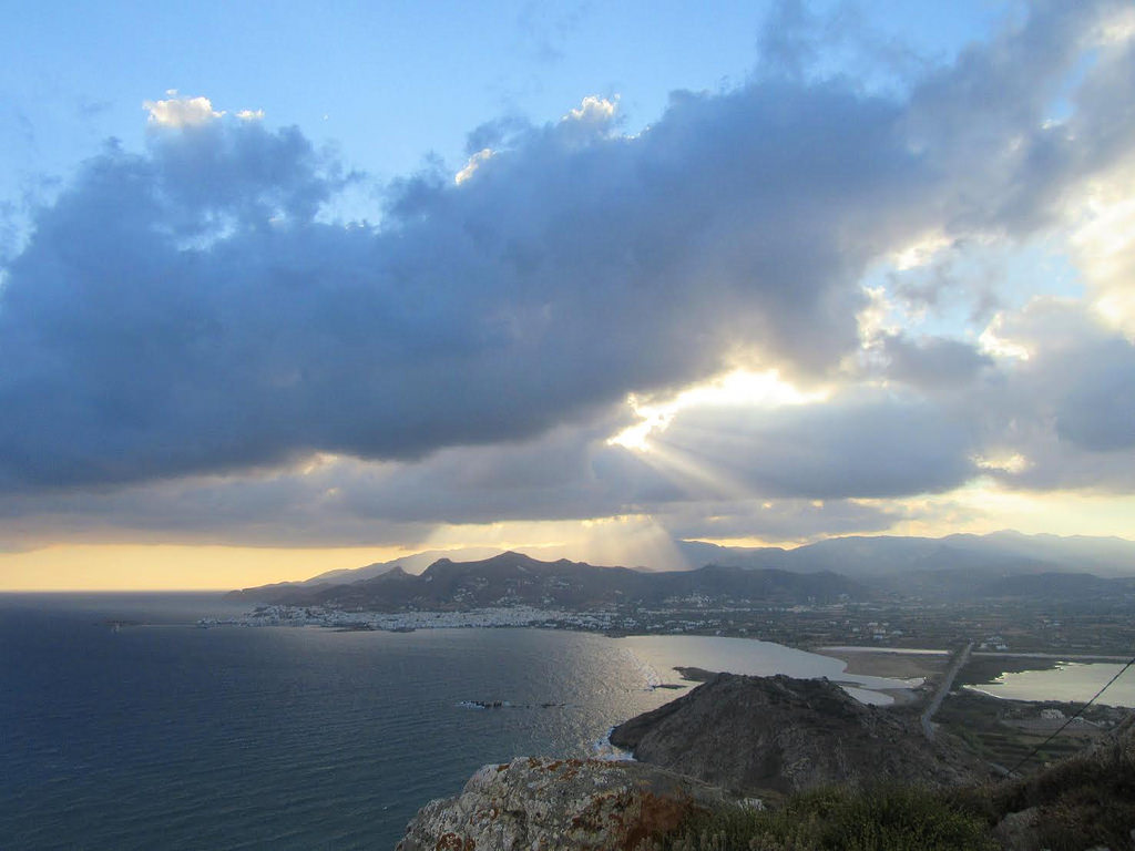
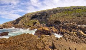
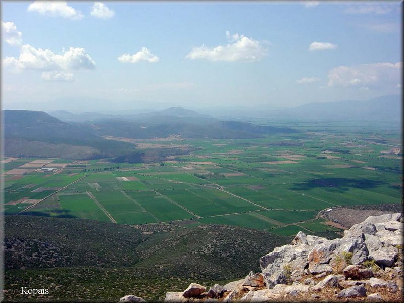 View of the Kopais from Glas
_____________________________
A Brief History of Glas and the Mycenaean World
The first Greeks descended through the Balkans into mainland Greece in ca. 2300/2200 BC (beginning of the Early Helladic III). They settled down mainly in the fertile inland, formed villages and eventually small towns, organized egalitarian societies and developed a distinct regional culture (Middle Helladic) based on agricultural economy and limited trade contacts with the Cyclades and eventually Crete. Rising to power was a long process realized through trade, diplomatic contacts, and constant warfare abroad and at home during the formative Early Mycenaean period (Late Helladic I-IIA/B, ca. 1650-1420/1410 BC). The Mycenaeans proved to be meticulous students: through increasing contacts with Minoan Crete, their trade horizons gradually expanded from the Balkans and Northern Europe to Egypt, the Levant, Cyprus, and Asia Minor. This gradual expansion is documented in the multicultural amalgam of stylistic, iconographic, technical elements and materials of the exquisite finds in the royal Shaft Graves at Mycenae (Minoan, Egyptian, European/Balkan, Hittite, and Helladic influences), the extensive corpus of foreign imports in Greece (orientalia and aegyptiaca), and the increasing Mycenaean exports abroad. Contemporary iconographical evidence (e.g. flotilla fresco from Akrotiri at Thera, silver Siege Rhyton from Grave Circle A at Mycenae) illustrate some of the early military achievements of the rising new power abroad: raiding foreign exotic lands (Egypt?) jointly with the Minoan fleet, sieging and sacking foreign towns. The Mycenaeans were recorded as Ahhiya or Ahhiyawa (~Homeric Achai(w)oi/Achaeans) in Hittite diplomatic documents already by 1420/1400 BC (since the reign of Tudhaliya II) and as Danaja or Tanaja (~ Homeric Danaoi) in Egyptian tribute lists like those of Thutmose III (ca. 1450 BC) and Amenhotep III (Karnak, ca. 1380 BC), or on a statue-base from Kom-el-Hetan (ca. 1380 BC), where Mukanu or mki[n] (~Mycenae) was listed first among mainland sites. In the following decades, the Danaja references in Egyptian sources gradually replaced the earlier Keftiu accounts and depictions of Minoan embassies of the 15th century BC, echoing contemporary archaeological evidence for drastic Mycenaean expansion and simultaneous reduction of Minoan presence abroad. This reversal of the political and military situation in the Aegean in the 14th century BC was triggered by the gradual infiltration and, arguably, military presence of the Mycenaeans on Crete in 1420/1410-1370 BC (Late Helladic IIIA1), in the wake of a devastating earthquake which had leveled the Minoan palaces and left the Minoan world in disarray. The Mycenaean occupation of Crete marked for the Minoans the beginning of the end and for the Mycenaeans the end of the beginning.
The Mycenaean world and particularly Mycenae flourished in the following two centuries (ca. 1420/1410-1200/1175 BC), a period known as Palatial Mycenaean or Late Helladic IIIA/B. The Minoan palaces served as modus operandi for the sociopolitical and economic organization of the rising Mycenaean states. This period is marked by regional centralization of power, state formation, and advanced socio-economic organization, geared towards efficient surplus of local production and overseas trade, both coordinated and regulated by the palace administration and sustained by palatial bureaucracy (Linear B). At home, the Mycenaean palaces were fortified into citadels, large-scale public works were carried out (such as the Kopais drainage system, the Tiryns dam, the Pylos bay) and production was systematized. Abroad, the Mycenaeans assumed control over the Minoan colonies and trade outposts in the Aegean and Eastern Mediterranean, and further expanded to the east and west, thus firmly establishing their own trade network and successfully succeeding the Minoans in the overseas trade (Mycenaean thalassocracy). A vital sector of the centralized palatial economy and sociopolitical structure, overseas trade required not only a tight network of island and coastal outposts, but also highly effective diplomacy. Diplomatic contacts involved exchange of royal letters and gifts, ambassadors, official royal visits, treaties and bilateral agreements. Certain Mycenaean palaces like Mycenae, Thebes, and Pylos maintained a protagonistic role in overseas trade of luxury/prestige goods and diplomatic contacts at the highest level. The organized trade of luxury/prestige goods which required a well-coordinated control mechanism for acquiring raw materials and producing artifacts or other products to be marketed in exchange, afforded luxury to the elite, while the king’s special access to external prestige goods reinforced royal image and authority. The exquisite artifacts found in tombs in the area of Mycenae, Pylos, and Thebes, as well as the great variety of precious materials recorded in palatial inventory lists and yielded in the archaeological contexts of palatial workshops further document privileged connections and constant contact with Egypt, Anatolia, and the Near East, closely following the successful Minoan archetype. The effective regulation of production and organization of the socio-economic life by the Mycenaean palatial administration was followed by a long period of prosperity and stability which led to population growth, as indicated by the rapid increase in the number and size of the Mycenaean settlements and cemeteries, and their geographical distribution in the homeland and abroad in the 13th century BC.
In the course of the 12th century BC, combined, rapid and dramatic changes in several socio-economic, political, and environmental variables affected a fragile balance and triggered a chain reaction of progressively magnified and multiplied cumulative effect, resulting inevitably in a catastrophic systems collapse which caused the decline and fall of the Mycenaean world. The latter half of the 13th century BC was marked by intense and frequent seismic activity in certain regions of mainland Greece (two major destruction horizons were recorded in the Argolid in ca. 1240 BC and 1200/1180 BC). These ‘earthquake storms’ caused severe structural damage, local fires, disorganization and disarray, immediate allocation of manpower for costly and energy-consuming repairs, and hence disruption of economic life and trade. A typical example of a low-diversified surplus-geared economy without sufficient alternative resources to fall back to, Mycenaean economy could hardly withstand and recover from temporary setbacks or survive the combined impact of various factors, such as natural catastrophes (earthquakes, extensive fires, severe climatic conditions, droughts, crop failure), ecological overexploitation, and palatial military/financial overextension. Natural disasters may have acted as catalysts for a catastrophic system failure, inflicting the final blow to the system: they eliminated short-term food supplies, destroyed high-yield specialized agricultural production and livestock, and consequently upset dependent satellite industries (flax, textile, wine and oil industries), disrupted trade, damaged the infrastructure, and demoralized the population. Inevitably, civil unrest, internal wars and raids by starving populations on less affected regions followed, causing decentralization and political fragmentation, dissolution of the socioeconomic nexus, severe depopulation of vital areas, and emigration to the coasts, islands, and overseas.
The three major Boeotian palatial centers, Thebes, Orchomenos, and Glas were destroyed by fire slightly earlier than Pylos, sometime in the advanced LH III B2 (ca. 1220/1200 BC), most likely by enemy action; Thebes and Orchomenos continued to exist and were reoccupied on a smaller scale, whereas Glas and the Kopais drainage works were completely destroyed and abandoned. This regional destruction may be associated with internal conflicts between the Mycenaean palaces of Thebes and Orchomenos, or, alternatively, may be attributed to external aggression by Mycenaeans from the Argolid. Both versions have been well-preserved in mythology, literature, and folk memory: according to mythical tradition, Thebes attacked and destroyed Orchomenos, with Heracles blocking the sinkholes and flooding the lake (Strabo IX.2.40), and the Argives repeatedly campaigned against and finally besieged Thebes (Seven against Thebes, and the Epigonoi); accordingly, the palace of Thebes (Kadmeia) was not included among the Boeotians in the “Catalogue of Ships” (Iliad II.494-516), a separate and possibly much older poem later embodied in the Iliad, and the king (wanax) of Thebes did not participate in the Trojan War which allegedly took place shortly after the destruction of Thebes.
The movement of peoples (called “Sea People” in the Egyptian sources) and the subsequent widespread destructions in Asia Minor and the Levant in the beginning of the 12th century BC led to the collapse of the Hittite Empire, but also eradicated the Mycenaean trade outposts and colonies in the East. The loss of their off-shore trade posts disrupted foreign trade and paralyzed the overseas sector of the centralized palatial economy, which, given the peripheral geopolitical location of Mycenaean Greece, depended on the contact with the main zone of exchange through intermediaries. That must have been another terrible blow to the already distressed and staggering palatial economy, forcing it to fall back on domestic production and isolation. In the course of the 12th century BC many small settlements in several regions (i.e. Argolid, Achaia, Attica, Euboia, Thessaly, islands, Cyprus, Asia Minor) sustained continuity and achieved substantial revival with their limited production and trade capacity, despite the general decline and fragmentation; on the contrary, the citadels of Mycenae, Tiryns, and Thebes, though partially repaired and reoccupied, and despite attempts for economic revival, never fully recovered and were gradually abandoned. The deterioration of the same system that had strengthened central palatial authority through the coordination and regulation of political and socioeconomic life resulted inevitably in the dissolution of the palaces’ power, decentralization and fragmentation of Mycenaean Greece. It appears, therefore, that it was the Mycenaean elite and its diagnostic, key elements (palatial administration and writing, foreign contacts and luxury goods, monumental art and megalithic architecture) that suffered the most from the system meltdown, whereas at a lower level the impact was less direct, and the core of Mycenaean society changed more gradually (in terms of basic material culture and cultural practices) and evolved organically into the Early Iron Age Greece.
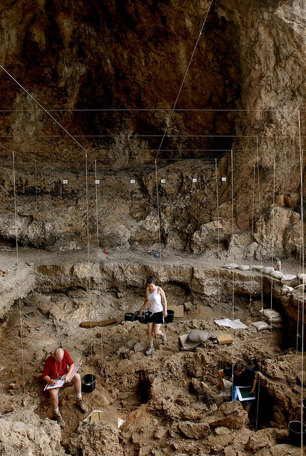
History of the Excavations
The citadel of Glas was partially excavated (central enclosures) by T.A. de Ridder (1893), I. Threpsiades (1955-1961) and Sp. Iakovidis (1981-1983, 1990-1991). The exemplary publication by Sp. Iakovidis (1989, 1998, 2001) of earlier and recent excavations in the Mycenaean citadel of Glas and the synthesis of archaeological, geoarchaeological, and historical evidence established the form, function, organization, importance and uniqueness of this archaeological site. Recently, however, the archaeological plan of Glas changed drastically as a result of a systematic geophysical survey (2010-2011) which was conducted under my direction and the auspices of the Athens Archaeological Society, and was generously funded by Dickinson College and the Institute for Aegean Prehistory (INSTAP). The geophysical survey was carried out by a team of archaeologists, graduate and undergraduate students, and teams of specialists from INSTAP, led by Prof. A. Stamos, and the Exploration Geophysics Laboratory of the Univ. of Thessaloniki, led by Prof. Gr. Tsokas. The geophysical survey of Glas changed the archaeological picture of the site but also questioned the established interpretations of its function and purpose. The final results of the systematic geophysical survey are being currently prepared for publication in an international archaeological journal.
Posing the Problem: fort or fortified settlement?
The form and layout of the citadel of Glas, as published by Iakovidis, did present certain spatial peculiarities:
- only one third or less of the total area of the citadel (49.5 acres or 20 ha) was occupied by various buildings and structures, whereas no other ruins were traced anywhere else in the citadel (V);
- the northern and southern enclosures (II, III) surround and demarcate groups of buildings within the citadel, delineate their spatial arrangement, differentiate between storage areas and administrative or residential sectors, and isolate these sectors from the remaining (arguably empty) fortified area for some elusive reason;
- the northeastern enclosure (I) contains no visible ruins, bears no definite entrance (except perhaps a couple of gaps in the peribolos wall that may have provided access), and its use remained obscure;
- the eastern enclosure (IV) is separated and isolated from the remaining fortified area, being apparently accessible only from outside the walls through the eastern entrance of the double Southeast Gate, and its precise use –being arguably void of any visible ruins– remained unclear.
The systematic geophysical survey of the citadel of Glas focused mainly on unexplored sectors aiming to produce new architectural evidence and further define the topography, layout, and use of the citadel, as well as trace earlier occupation phases of the site. The project involved remote-sensing investigation of the following areas:
- the northern and southern enclosures (II, III) to trace potentially other Mycenaean buildings, subsidiary structures, storage areas, retaining walls, terraces, courtyards, and roads;
- the vast ‘void’ fortified area (V) to detect potentially a Mycenaean settlement within the citadel and/or earlier occupation remains on the hill of Glas (as suggested by scattered Neolithic pottery and stone tools);
- the northeastern enclosure (I) and the eastern enclosure of the citadel (IV) to detect potentially Mycenaean ruins or diagnostic geomagnetic traces of human activities related to the use of land (e.g. cultivation, extensive burning, metallurgy, walking surfaces and artificial terracing).
Re-discovering Glas: Methods and Results of the Geophysical Survey
Aside from certain areas of the citadel (plateaus or steep slopes) that have been severely eroded down to the natural bedrock, the natural fill of the hill is approximately 1 m deep or deeper, when it contains artificial fills, archaeological layers, and ruins. The geophysical remote-sensing survey was conducted with a Ground Penetrating Radar (GPR) and a Fluxgate Gradiometer. Both types of equipment produce detailed images to a depth of 2 m. The portable geomagnetometer (Geoscan FM256 Fluxgate Gradiometer processed with Geoplot software) detects positive or negative anomalies in the magnetic field of the Earth and records them as dark grey or black features (positive magnetic anomalies potentially reflecting ditches, backfills, clay floors, intense firing, burnt mudbrick, metal finds) and light grey or white features (negative magnetic anomalies possibly indicating stone walls, pavements, stone piles). The fluxgate gradiometer offers several advantages, namely speed of geoprospection (on average one acre per day), portability, and use on irregular terrains or over low vegetation, as it does not involve any contact with the ground; on the down side, however, the gradiometer reproduces two-dimensional geoprospection images of the magnetic traces which are conflated and compressed on a single plane without any real indication of depth. On the other hand, the GPR (Subsurface Interface Radar or SIR-2000 with a 400MHz antenna) is considerably slower, as it is wheeled on the ground and, therefore, requires extensive preparatory work in the form of surface clearing; furthermore, it involves collection of data in two perpendicularly-oriented datasets with repeated passing on closely-spaced transects of an orthogonal grid to better detect subsurface features. The GPR, however, generates three-dimensional geoprospection images of the buried remains (stone walls and floors, rubble piles) with precise depth scale. The vast size of the citadel, the occasionally rough terrain and wild bush vegetation on the hill, and the need for time efficiency dictated a well-planned combination of both methods: at first, extensive and generalized use of the gradiometer for fast and immediate results, followed by targeted use of the GPR on select areas or sectors that present strong or diagnostic geomagnetic traces. Such combination of these two methods proved exceptionally successful and precise at Mycenae (2003-2013), where the systematic geophysical survey detected, recorded, and plotted extensive remains of the Lower Town outside the citadel.
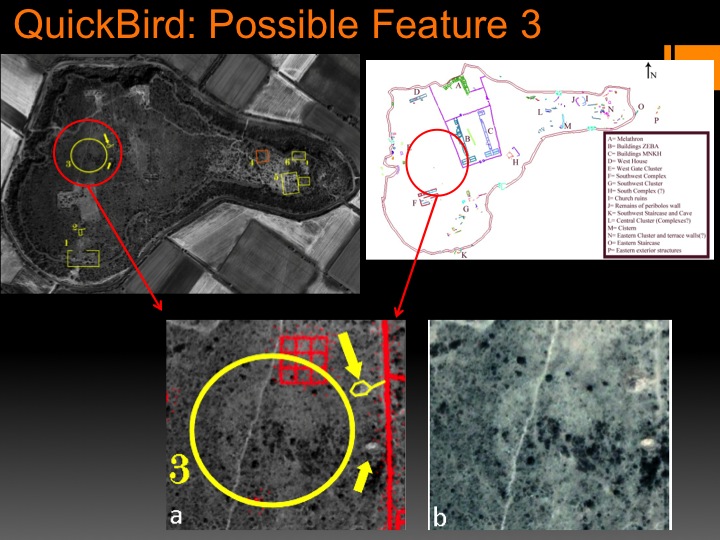
Other geoprospection methods, such as Electrical Resistivity and Quickbird satellite panchromatic and multispectral imagery were also successfully employed at Glas. Geodetic measurements, the plotting of the survey grid, and the detailed mapping of all buried remains and features were done with the aid of Differential Global Positioning System (GPS) and Total Station. The topographical, archaeological, spatial, and geophysical data will be embedded in the G.I.S. database of Dickinson College and 3-D digital maps.
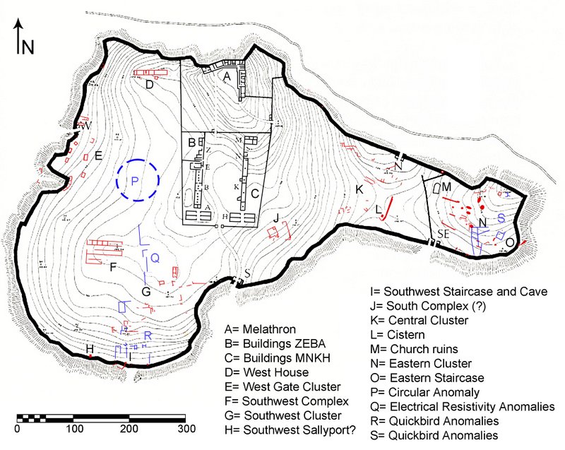
The geophysical survey focused on the two large northern enclosures (I, II), the western/central sector (V), and the eastern sector of the citadel (IV). The indications from the enclosures were rather poor due to severe ground erosion on the summit and the slopes. The results, however, from the western/central and eastern sectors of the citadel and the cyclopean fortification wall were impressive. Several buildings were detected, including three large, well-built complexes (D, F, J) consisting of long rectangular buildings with several large rooms. Clusters of walls, rooms, small buildings, and silos (E, G, K, N) were located between the large complexes, occasionally abutting on the inner face of the cyclopean wall.
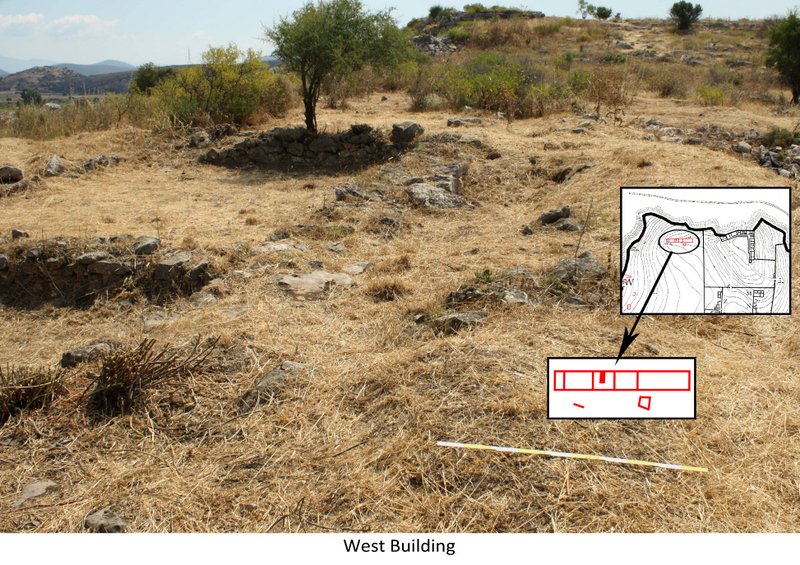
In the northwestern part of the citadel lies the West Building (D) with an E-W orientation. This building complex consists of an oblong rectangular structure divided by at least four parallel partition walls into a row of five rooms, with the central two rooms being of equal size. Another parallel room and few wall remains were traced immediately south of the West Building and may belong to the same complex. A cluster of scattered rooms (E) were further explored in the vicinity of the West Gate, which may belong to a residential quarter, as indicated by their small size, simple plan, different orientation, and relatively poor construction. Among them, immediately north of the West Gate, lies a two-room (guard house?) abutting on the inner face of the western cyclopean wall (West Gate Building), while, farther south of this gate, four semi-circular rooms (silos?) were built against a recess of the western cyclopean wall.
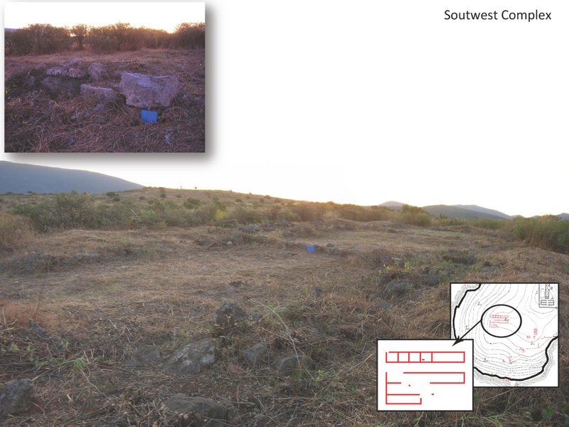
The southwestern area of the citadel is accessible from both the West Gate and the South Gate, and is dominated by the plateau of a low hill, which is occupied by a large building complex and possibly enclosing other important structures as well (P, Q, R). The Southwest Complex (F) consists of at least three parallel, oblong rectangular wings of similar ground plan and same orientation as the West Building, divided by parallel partition walls into rows of large rooms. The complex has solid walls constructed of roughly dressed, large blocks. The size, construction and ground plan of the Southwest Complex and the West Building recall the two parallel, long storage buildings in the southern central enclosure (Sector III: B, C). Another cluster of scattered buildings, rooms, and wall remains (Southwest Cluster, G) were detected to the southeast of the Southwest Complex, which may belong to a residential quarter, as indicated by their relatively small size, simple plan, different orientation and construction.
_______________________________
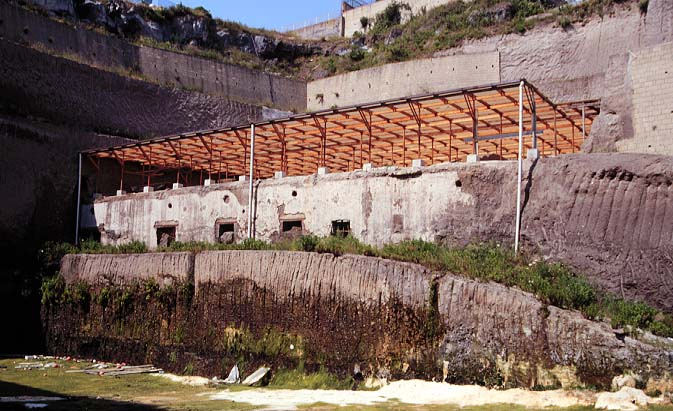
 The Glas site general plan
_______________________________
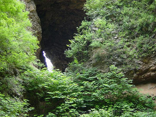
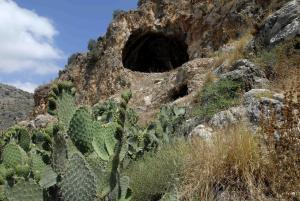
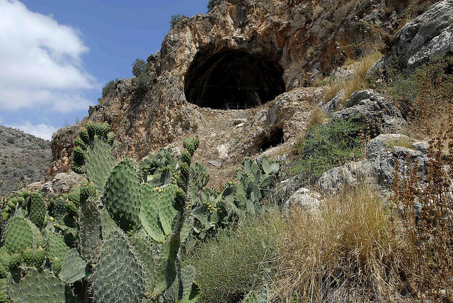
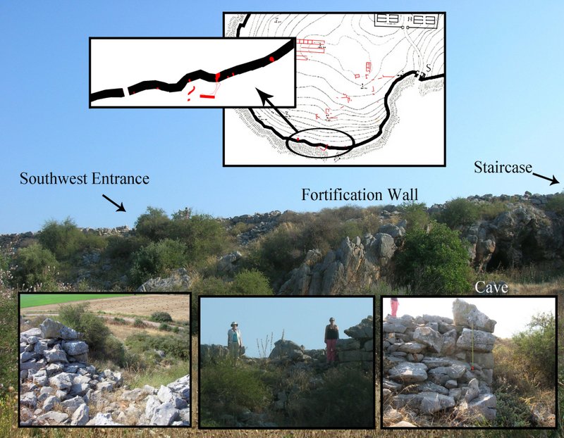
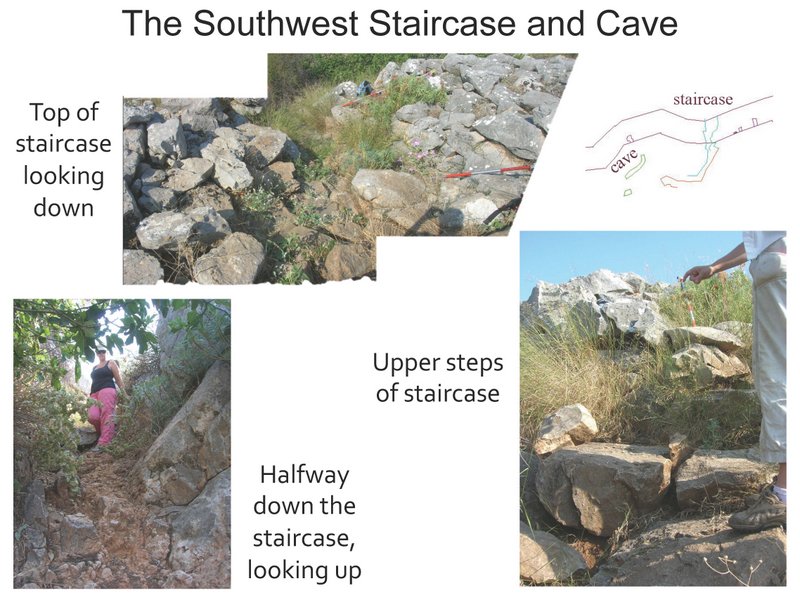
In the southern sector of the cyclopean wall, approximately midway between the West and the South Gate, two sally ports were discovered, thus raising the number of gates in the citadel of Glas to six. The southwest sally port (H) is 3 m wide and gives access to a low terrace in front of the wall that affords unobstructed viewing of the plain to the south. The other sally port (I), located 60 m to the east, facilitates safe descent to the plain below via a narrow and steep staircase that was partly built and partly hewn out of the bedrock, providing access to a cave at the base of the rocky hill. Between the two sally ports were identified five narrow rectangular niches (1 m x 3 m) opening into the outer face of the wall with no access from within the citadel, but once accessible possibly through trapdoors from the upper part of the wall. These niches were likely sentry boxes associated with the guarding of the adjacent sally ports. Two more niches were located in the northern and western sectors of the cyclopean wall. Finally, traces of large rectangular rooms (casemates or towers) were detected within the thickness of the cyclopean wall in the western sector (100 m north of the west gate), in the northeastern sector (70 m east of the north gate), and in the southwestern sector (200 m west of the south gate and east of the sally ports).
The geophysical survey expanded eventually in the central and the eastern part of the citadel with equally impressive results. In the central area (Sector V) lies the South Complex (J), which consists of a large building with a NW-SE orientation, flanked by a parallel oblong rectangular wing. Farther to the northeast of this complex were detected a cluster of scattered buildings, rooms, and wall remains (Central Cluster, K). This cluster includes a multi-room building (Central Building 1), an oblong rectangular wing of another building with an E-W orientation (Central Building 2), and a cyclopean cistern (L), partly built and partly hewn out of the bedrock, which is associated with a long retaining wall with a N-S orientation. The oblong wings of the central buildings, though smaller in size, are similar to those of the West Building and the Southwest Complex.
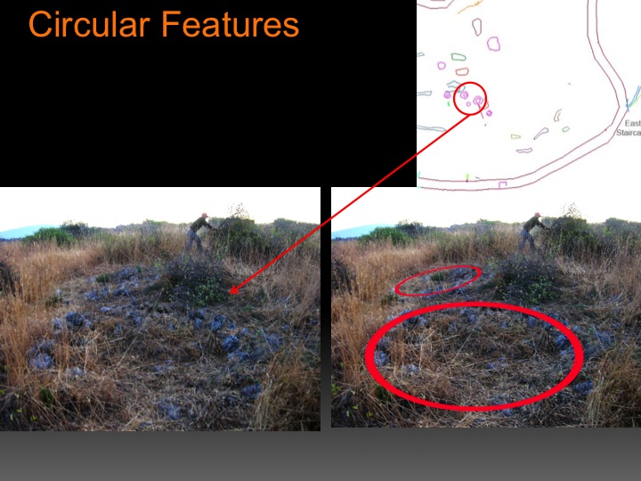
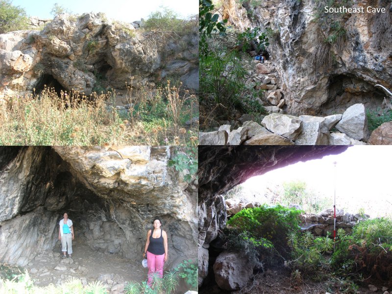
The eastern part of the citadel (between Sectors IV and V) preserves a surviving corner of the cross-wall that ran at an angle from the northeastern course of the cyclopean wall to the central tower of the double Southeast Gate.SE orientation, flanked by a parallel oblong rectangular wing. Farther to the northeast of this complex were detected a cluster of scattered buildings, rooms, and wall remains (Central Cluster, K). This cluster includes a multi-room building (Central Building 1), an oblong rectangular wing of another building with an E-W orientation (Central Building 2), and a cyclopean cistern (L), partly built and partly hewn out of the bedrock, which is associated with a long retaining wall with a N-S orientation. The oblong wings of the central buildings, though smaller in size, are similar to those of the West Building and the Southwest Complex. This cross-wall separated and isolated the eastern part of the citadel (Sector IV) which was, thus, accessible only from the eastern entrance of the double Southeast Gate. This isolated eastern sector of the citadel contained scattered structures (East Cluster, N), including several retaining walls for terracing with an E-W orientation, walls and rooms of various buildings, and at least ten circular structures (2.5-3 m in diameter), possibly silos(?). Six of these circular structures are located in the center of the eastern sector, while four more were traced near the northeastern course of the cyclopean wall. Outside the eastern course of the cyclopean wall was found a built staircase (East Staircase, O); furthermore, several caves and sinkholes were located, mapped, and briefly surveyed at the foot of the rocky hill of Glas.
________________________________
 _______________________________
 __________________________________________
 __________________________________________
 __________________________________________
 _________________________________________
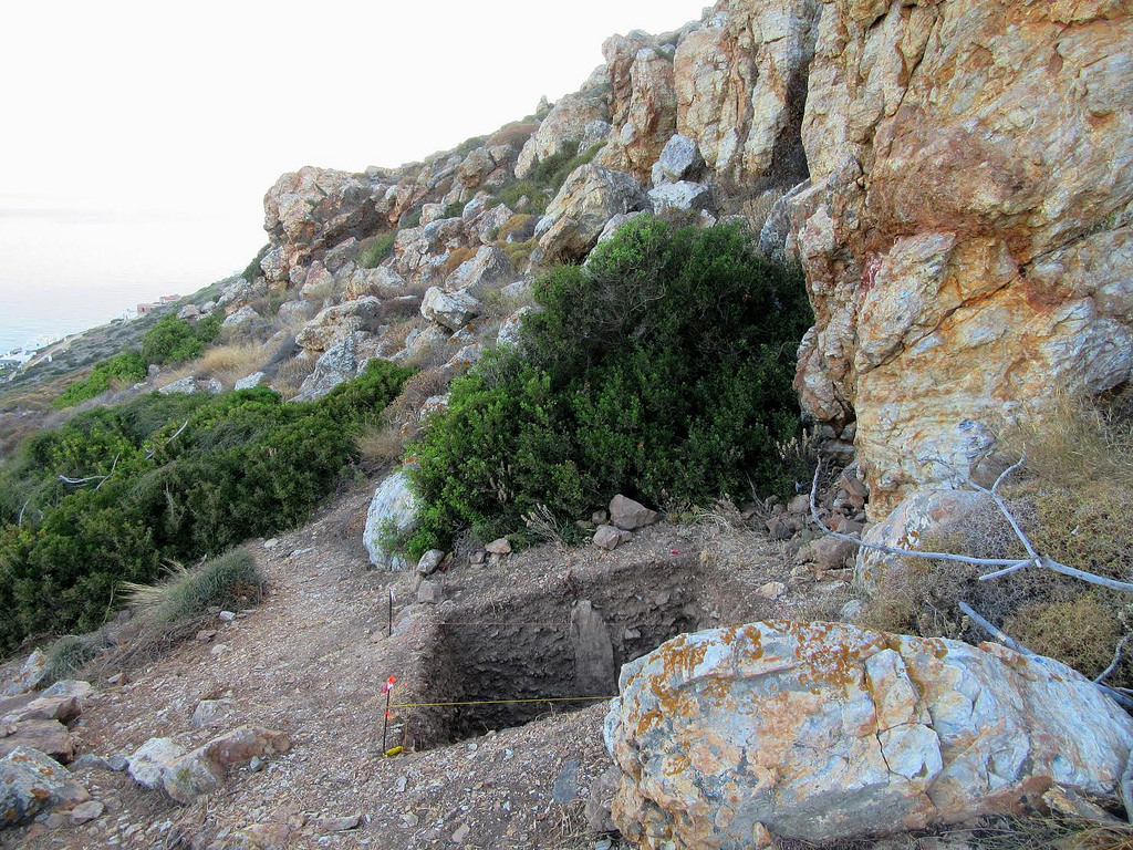
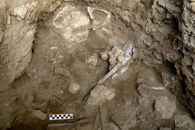
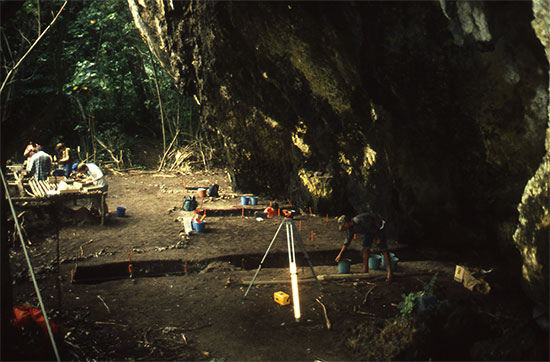
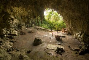
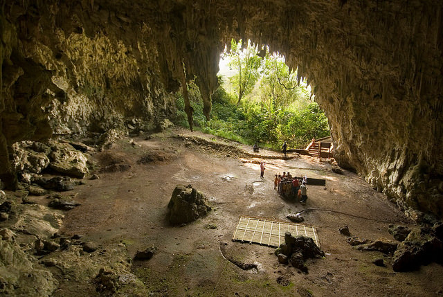
 Caves at Glas
_________________________________________
 ________________________________________
 _______________________________________
 _________________________________________
Assessing the Importance of Glas
The old archaeological picture of Glas changed drastically and, consequently, the traditional interpretation of the citadel as a fort is now being challenged. So far, the citadel of Glas presented the layout of a fort with enigmatic spatial peculiarities; our geophysical survey established that the citadel area was not left void of structures outside the central enclosures after all, but was apparently covered with many buildings of various uses, including several large, well-built complexes, extensive residential quarters and clusters of buildings stretching between these complexes, circular structures (silos?), a cistern, sally ports, staircases, retaining walls and terraces. Glas, therefore, may not have been merely a fort maintaining the drainage works and managing agricultural production; apparently, there is a whole city within the walls, whose identification raises interesting questions about Mycenaean political geography. The Homeric poems (Catalogue of Ships) and later literary sources list several important Mycenaean towns in the Kopais area (Arne among them); could Glas be identified with one of these towns? Alternatively, is it possible that Glas was a third, unknown so far, regional palatial center? If so, we would need to explore the dynamics between this regional administrative center and satellite peripheral settlements in the Kopais basin, and define the relations between the palatial centers of Glas, Orchomenos and Thebes in the framework of the Mycenaean political geography. Finally, a far more intriguing hypothesis: what if Glas is Orchomenos? Is it possible that the palatial authorities of Orchomenos moved their palace and settlement to the most strategically important and highly defensible location available after the draining of the marshland of Kopais in the 13th century BC, while using the original site of Orchomenos mainly as an ancestral burial place?
Unfortunately, despite such astonishing discoveries and fascinating prospects, the state-approved, five-year, systematic geophysical survey of Glas was abruptly suspended by the Athens Archaeological Society in 2012 after only the first two years of operation, on grounds of complete lack of interest in further exploring the site. The systematic investigation of the Mycenaean citadel of Glas will hopefully continue and must intensify in the next few years to unearth convincing answers to all these intriguing questions. The geophysical survey and excavation of this monumental site can offer field training to hundreds of undergraduate and graduate students through the D.E.P.A.S. project of Dickinson College, great opportunities for faculty/student collaborative research, doctoral theses, interdisciplinary collaboration and leading scholarship for scholars and researchers from around the world.
_______________________________________________
For information, see the Project website: http://glas-excavations.org
Contact information to participate or donate to the project: contact Prof. Chr. Maggidis at [email protected] and (717) 245-1014
_______________________________________________
Did this article interest you? You can read more like this with a premium subscription to Popular Archaeology.
_______________________________________________


 By comparing the genomes to one another as well as to those of nearly 240 previously studied ancient people from nearby regions and about 2,600 present-day people, the researchers learned that the first farming cultures in the Levant, Iran and Anatolia were all genetically distinct. Farmers in the Levant and Iran were genetically similar, however, to earlier hunter-gatherers who had lived in the same areas.