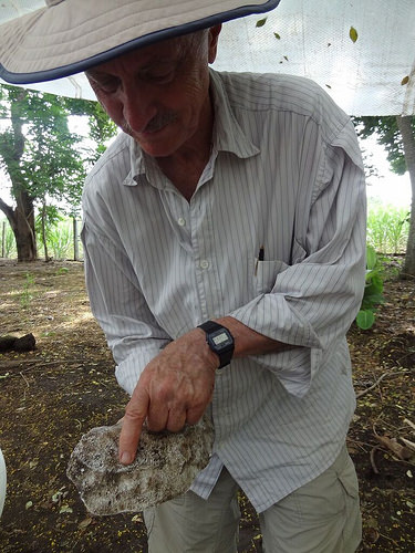
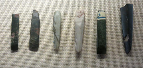
UNIVERSITY OF CAMBRIDGE—A box of seemingly unremarkable stones sits in the corner of Dr Giulio Lucarini’s office at the McDonald Institute for Archaeological Research where it competes for space with piles of academic journals, microscopes and cartons of equipment used for excavations.
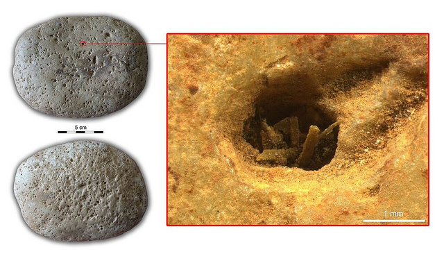
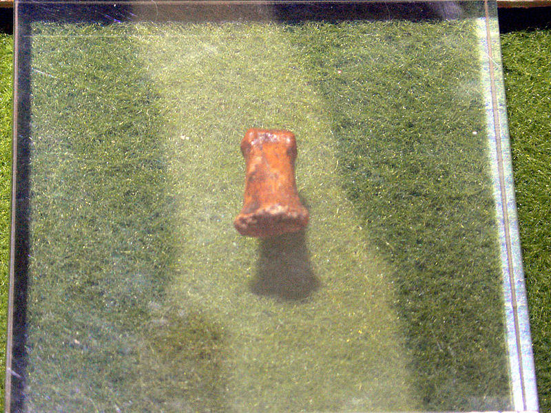
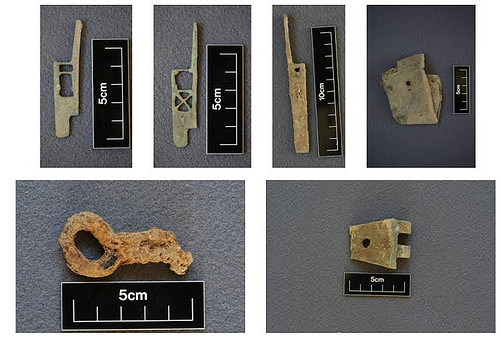
These palm-sized pebbles were used as grinding tools by people living in North Africa around 7,000 years ago. Tiny specks of plant matter recently found on their surfaces shine light on a fascinating period of human development and confirm theories that the transition between nomadic and settled lifestyles was gradual.
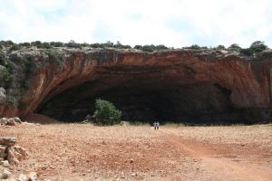
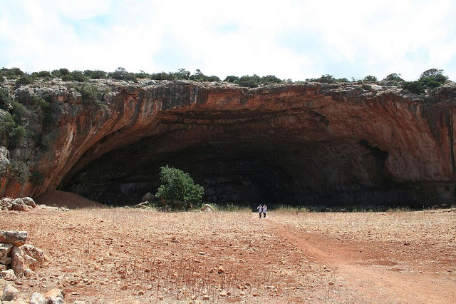
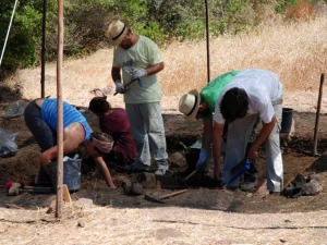
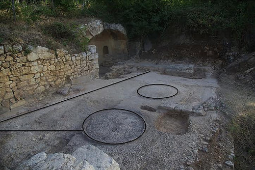
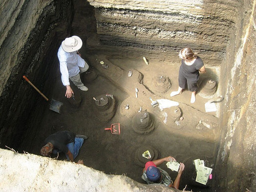
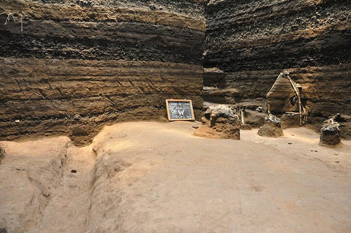
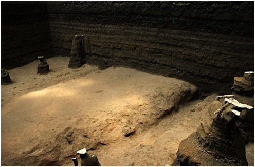
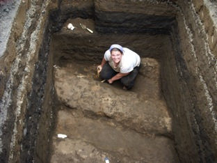
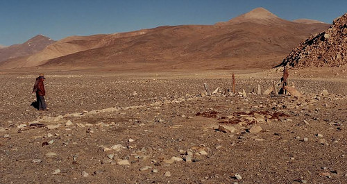
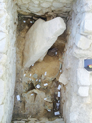
The artefacts in Lucarini’s office come from a collection held in the store of the Museum of Archaeology and Anthropology (MAA) just a couple of minutes’ walk away. In the 1950s the well-known Cambridge archaeologist Sir Charles McBurney undertook an excavation of a cave called Haua Fteah located in northern Libya. He showed that its stratigraphy (layers of sediment) is evidence of continuous human habitation from at least 80,000 years ago right up to the present day. Finds from McBurney’s excavation were deposited at MAA.
In 2007, Professor Graeme Barker, also from Cambridge, started to re-excavate Haua Fteah with support from the ERC-funded TRANS-NAP Project. Until 2014, Barker and his team had the chance to spend more than one month each year excavating the site and surveying the surrounding Jebel Akhdar region, in order to investigate the relationships between cultural and environmental change in North Africa over the past 200,000 years.
Now an analysis of stone grinders from the Neolithic layers of Haua Fteah (dating from 8,000-5,500 years ago), carried out by Lucarini as his Marie Sklodowska-Curie Project ‘AGRINA’, in collaboration with Anita Radini (University of York) and Huw Barton (University of Leicester), yields new evidence about people living at a time seen as a turning point in human exploitation of the environment, paving the way for rapid expansion in population.
Around 11,000 years ago, during the early phase of the geological period known as Holocene, nomadic communities of Near Eastern regions made the transition from a hunter-gatherer lifestyle to a more settled farming existence as they began to exploit domesticated crops and animals developed locally. The research Lucarini is carrying out in Northern Libya and Western Egypt is increasingly revealing a contrasting scenario for the North African regions.
In a paper published today, Lucarini and colleagues explain that the surfaces of the grinders show plant use-wear and contain tiny residues of wild plants that date from a time when, in all likelihood, domesticated grains would have been available to them. These data are consistent with other evidence from the site, notably those from the analysis of the plant macro-remains carried out by Jacob Morales (University of the Basque Country), which confirmed the presence of wild plants alone in the site during the Neolithic. Together, this evidence suggests that domesticated varieties of grain were adopted late, spasmodically, and not before classical times, by people who lived in tune with their surroundings as they moved seasonally between naturally-available resources.
Lucarini is an expert in the study of stone tools and has a particular interest in the beginning of food production economies in North Africa. Using an integrated approach of low and high-power microscopy in the George Pitt-Rivers Lab at the McDonald Institute, and in the BioArCh Lab at the University of York, he and his colleagues were able to spot plant residues, too small to be visible to the naked eye, caught in the pitted surface of several of the stones from Haua Fteah. Some of the grinders themselves exhibit clear ‘use-wear’ with their surfaces carrying the characteristic polish of having been used for grinding over long periods.
“It was thrilling to discover that microscopic traces of the plants ground by these stones have survived for so long, especially now that we’re able to use powerful high-power microscopes to look at the distinctive shape of the starch granules that offer us valuable clues to the identities of the plant varieties they come from,” says Lucarini.
By comparing the characteristic shape and size of the starch found in the grinders’ crevices to those in a reference collection of wild and domestic plant varieties collected in different North African and Southern European countries, Lucarini and Radini were able to determine that the residues most probably came from one of the species belonging to the Cenchrinae grasses.
Various species of the genus Cenchrus are still gathered today by several African groups when other resources are scarce. Cenchrus is prickly and its seed is laborious to extract. But it is highly nutritious and, especially in times of severe food shortage, a highly valuable resource.
“Haua Fteah is only a kilometre from the Mediterranean and close to well-established coastal routes, giving communities there access to commodities such as domesticated grain, or at least the possibility to cultivate them. Yet it seems that people living in the Jebel Akhdar region may well have made a strategic and deliberate choice not to adopt the new farming practices available to them, despite the promise of higher yields but, instead, to integrate them into their existing practices,” says Lucarini.
“It’s interesting that today, even in relatively affluent European countries, the use of wild plants is becoming more commonplace, complementing the trend to use organically farmed food. Not only do wild plants contribute to a healthier diet, but they also more sustainable for the environment.”
Lucarini suggests that North African communities delayed their move to domesticated grains because it suited their highly mobile style of life. “Opting to exploit wild crops was a successful and low-risk strategy not to rely too heavily on a single resource, which might fail. It’s an example of the English idiom of not putting all your eggs in one basket. Rather than being ‘backward’ in their thinking, these nomadic people were highly sophisticated in their pragmatism and deep understanding of plants, animals and climatic conditions,” he says.
Evidence of the processing of wild plants at Haua Fteah challenges the notion that there was a sharp and final divide between nomadic lifestyles and more settled farming practices – and confirms recent theories that the adoption of domesticated species in North Africa was an addition to, rather than a replacement of, the exploitation of wild resources such as the native grasses that still grow wild at the site.
“Archaeologists talk about a ‘Neolithic package’ – made up of domestic plants and animals, tools and techniques – that transformed lifestyles. Our research suggests that what happened at Haua Fteah was that people opted for a mixed bag of old and new. The gathering of wild plants as well as the keeping of domestic sheep and goats chime with continued exploitation of other wild resources – such as land and sea snails – which were available on a seasonal basis with levels depending on shifts in climatic conditions,” says Lucarini.
“People had an intimate relationship with the environment they were so closely tuned to and, of course, entirely dependent on. This knowledge may have made them wary of abandoning strategies that enabled them to balance their use of resources – in a multi-spectrum exploitation of the environment.”
Haua Fteah continues to pose puzzles for archaeologists. The process of grinding requires two surfaces – a hand-held upper grinding tool and a base grinding surface. Excavation has yielded no lower grinders which made have been as simple as shallow dish-shaped declivities in local rock surfaces. “Only a fraction of the extensive site has been excavated so it may be that lower grinders do exist but they simply haven’t been found yet,” says Lucarini.
The uncertain political situation in Libya has resulted in the suspension of fieldwork in Haua Fteah, in particular the excavation of the Neolithic and classical layers of the cave. Lucarini hopes that a resolution to the current crisis will allow work to resume within the next few years. He says: “Haua Fteah, with its 100,000 years of history and continuous occupation by different peoples, is a symbol of how Libya can be hospitable and welcoming. We trust in this future for the country.”
Source: University of Cambridge subject news release.
This richly illustrated issue includes the following stories: Two remarkable discoveries that are shedding light on human beginnings in Africa; a traveling exhibit and an archaeological site that show how knowledge is more valuable than gold; a Spanish cave and a unique burial that are offering a tantalizing glimpse on the lives of Ice Age hunter-gatherers in Europe; the stunning visual reconstruction of an ancient Roman town; enlightening new finds at a remarkably well-preserved site of ancient Hellenistic-Roman culture overlooking the Sea of Galilee; rare finds that are shedding light on occult practices among ancient Greeks in Sicily; and an overview of the overwhelmingly rich archaeological heritage of Britain. Find it on Amazon.com.
STOCKHOLM UNIVERSITY—Human material from the Anatolian site Kumtepe was used in the study. The material was heavily degraded, but yielded enough DNA for the doctorate student Ayca Omrak to address questions concerning the demography connected to the spread of farming. She conducted her work at the Archaeological Research Laboratory.
“I have never worked with a more complicated material. But it was worth every hour in the laboratory. I could use the DNA from the Kumtepe material to trace the european farmers back to Anatolia. It is also fun to have worked with this material from the site Kumtepe, as this is the precursor to Troy”, says doctorate student Ayca Omrak, at the Archaeological Research Laboratory Stockholm University.
Jan Storå, associate professor in osteoarchaeology and coauthor to the study agrees with Ayca. The results confirms Anatolias importance to Europe’s cultural history. He also thinks that material from the area needs to be researched further.
“It is complicated to work with material from this region, it is hot and the DNA is degraded. But if we want to understand how the process that led from a hunter-gatherer society proceeded to a farming society, it is this material we need to exhaust”, says Jan Storå, associate professor in osteoarchaeology, Stockholm University.
_______________________________________________
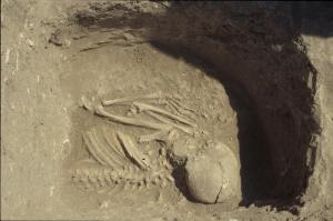
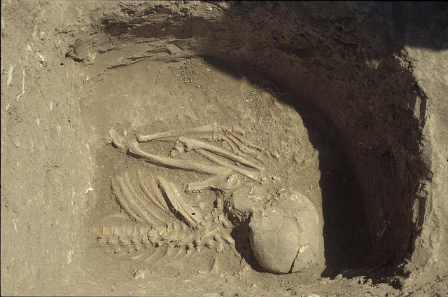
A large part of results come from grave 6 in Kumtepe, excavated in 1994. Here the upper part of a skeleton. Photo provided by Project Troia, thanks to Peter Jablonka. Photo provided by Project Troia, thanks to Peter Jablonka.
Anders Götherstörm who heads the archaeogenetic research at the Archaeological Research Laboratory agrees that this study indicates further possibilities:
“Our results stress the importance Anatolia has had on Europe’s prehistory. But to fully understand how the agricultural development proceeded we need to dive deeper down into material from the Levant. Jan is right about that.”
The archaeogenetic group in Stockholm is presently advancing its collaboration with colleagues in Anatolia and Iran.
This richly illustrated issue includes the following stories: Two remarkable discoveries that are shedding light on human beginnings in Africa; a traveling exhibit and an archaeological site that show how knowledge is more valuable than gold; a Spanish cave and a unique burial that are offering a tantalizing glimpse on the lives of Ice Age hunter-gatherers in Europe; the stunning visual reconstruction of an ancient Roman town; enlightening new finds at a remarkably well-preserved site of ancient Hellenistic-Roman culture overlooking the Sea of Galilee; rare finds that are shedding light on occult practices among ancient Greeks in Sicily; and an overview of the overwhelmingly rich archaeological heritage of Britain. Find it on Amazon.com.
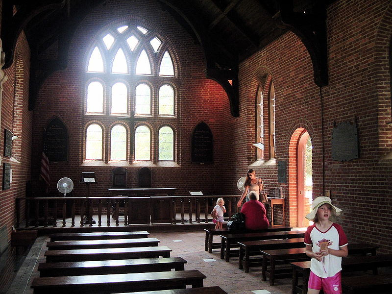
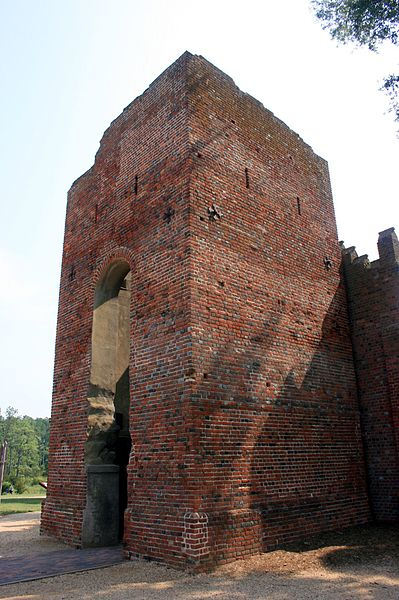
Archaeologists currently at work at the site of Jamestown, Virginia, the earliest successful English settlement in the Americas, plan to begin excavations at the spot of the 1907 Memorial Church on Jamestown Island. According to a recent published news update, beginning in the summer of 2016 they plan to excavate into the floor of the church in sections while keeping the historic church site open to visitors. The efforts will include an investigation into the remains of the 1617 church where English colonial America’s first representative government met in 1619.
The excavations at Jamestown are best known for the rediscovery of the remains of the 1607 James Fort by William Kelso in the mid-1990’s. Since then, archaeologists have recovered more than 2 million artifacts and thousands of features that evidence the remains of various structures, particularly those associated with the original 1607 James Fort. The findings testify to the successful establishment and growth of a key English colony and the place where the first English colonial government had its birth.
______________________________________________
Inside the currently reconstructed 1907 Memorial Church at Jamestown.
This richly illustrated issue includes the following stories: Two remarkable discoveries that are shedding light on human beginnings in Africa; a traveling exhibit and an archaeological site that show how knowledge is more valuable than gold; a Spanish cave and a unique burial that are offering a tantalizing glimpse on the lives of Ice Age hunter-gatherers in Europe; the stunning visual reconstruction of an ancient Roman town; enlightening new finds at a remarkably well-preserved site of ancient Hellenistic-Roman culture overlooking the Sea of Galilee; rare finds that are shedding light on occult practices among ancient Greeks in Sicily; and an overview of the overwhelmingly rich archaeological heritage of Britain. Find it on Amazon.com.
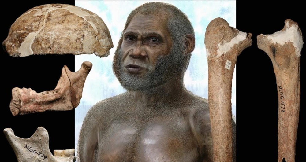
Using state-of-the-art dating methodologies, a team of scientists have obtained or confirmed a date range between .9 and .85 Mya (million years ago) as a time when a species of Old World monkey (Theropithecus) and an early species of human occupied the cave site of Cueva Victoria in southeastern Spain. It is a location not far from where many scientists have hypothesized that humans may have crossed over into Europe from North Africa through the Strait of Gibraltar at a time when seal levels were low enough to provide a land bridge between the two continents.
Using paleomagnetism, uranium-thorium, and vertebrate biostratigraphy dating techniques, Luis Gibert of the University of Barcelona, Spain, and colleagues from several other institutions conducted testing on fossiliferous breccia samples and other deposit samples from the cave. Their results showed that the fossil evidence for the Theropithecus presence was constrained to a range between .9 and .85 Mya. Similar dates have been obtained through previous studies on the Cueva Negra cave in the same region of Spain, which contained evidence of early human (Homo) fossils associated with what is arguably considered to be the earliest Acheulean-type stone tools in Europe.
The authors of the study suggest that the presence of the same species of Theropithecus, including Homo, at about the same time in North Africa, coupled with the absence of Theropithecus fossils elsewhere in Europe, supports the hypothesis of a dispersal of the two primates (Theropithecus and Homo) through the Strait of Gibraltar almost 1 million years ago. During this time, sea levels were low enough to create a land bridge at the Strait between Africa and Europe.
Previous studies by other teams have also suggested another, earlier human dispersal into southeastern Spain through the Strait of Gibraltar at about 1.3 million years ago, and the famous research and Homo fossil discoveries at Dmanisi in Georgia have suggested an even earlier Homo dispersal out of Africa, possibly through the Levant and up through Anatolia to the southern Caucasus at around 1.8 million years ago.
*Luis Gibert, et al., Chronology for the Cueva Victoria fossil site (SE Spain): Evidence for Early Pleistocene Afro-Iberian dispersals, 12 November 2015, Journal of Human Evolution. doi:10.1016/j.jhevol.2015.08.002
This richly illustrated issue includes the following stories: Two remarkable discoveries that are shedding light on human beginnings in Africa; a traveling exhibit and an archaeological site that show how knowledge is more valuable than gold; a Spanish cave and a unique burial that are offering a tantalizing glimpse on the lives of Ice Age hunter-gatherers in Europe; the stunning visual reconstruction of an ancient Roman town; enlightening new finds at a remarkably well-preserved site of ancient Hellenistic-Roman culture overlooking the Sea of Galilee; rare finds that are shedding light on occult practices among ancient Greeks in Sicily; and an overview of the overwhelmingly rich archaeological heritage of Britain. Find it on Amazon.com.
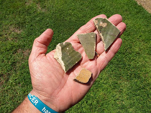
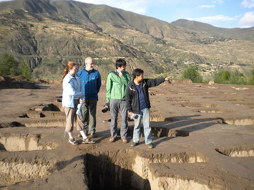
Archaeologists who have surveyed and dug for decades on Roanoke Island and other locations in North Carolina have accumulated important, albeit comparatively scant, evidence that have raised new questions about the whereabouts of America’s first main English settlement location and the mystery of the ‘lost colony’ of 1587.
Busy at work at a site known as Salmon Creek (otherwise known as ‘Site X’), which has yielded evidence of a long-gone Native American village settlement not far from the waterline on land bordering the Western Albemarle Sound of North Carolina, archaeologists have recently recovered some tantalizing fragments. Among scores of artifacts that tell of the 16th-17th century presence of Native Americans at the location, the archaeologists have uncovered artifacts that are clearly European in origin. The finds included 27 sherds representing perhaps 4 vessels of 16th century Surrey-Hampshire Border ware; 3 sherds of a North Devon plain baluster jar—a ceramic ware commonly used during the 16th and 17th centuries as provisioning jars on sea voyages—a tenter hook, of a type similar to that used at the early Jamestown settlement and possibly used to stretch canvas to create temporary shelters or to stretch and dry animal skins; a priming pan from an early (possibly 16th century) flintlock gun as well as another possibly from a 16th century snaphaunce gun; an aglet of the type that would have secured Elizabethan clothing; a fragment from an iron buckle typical of the style worn in the 16th and 17th centuries; and a lead cloth seal that may possibly be 16th or 17th century. The site investigators say that the finds are significant in that the earliest recorded presence of English settlement in the western Albemarle Sound area did not occur earlier than about 1655.
______________________________________________
Excavations underway at the Salmon Creek site, or ‘Site X’. Courtesy First Colony Foundation
The recent findings have made news headlines at a variety of venues in 2015. But is it unequivocal evidence for the long-sought whereabouts of the famous ‘lost colony’ of 1587?
Yes and no, say the archaeologists of the First Colony Foundation, the organization under which recent excavations have been conducted at the site.
“The First Colony Foundation believes [hypothesizes] that it has uncovered archaeological evidence of Roanoke colonists’ presence at Site X,” write the site investigators in their report.* However, they qualify their statement with another statement documented in the same report: They “do not contend that Site X on its own represents the relocation site for the majority of 1587 colonists.”* They suggest that any habitation by Roanoke colonists at the site may have only consisted of a small surviving part of the original 1587 group.
So where did the rest go?
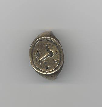
When colony Governor John White finally returned in 1590 to the 1587 settlement site after three frustrating years held in England due to the British Crown’s maritime conflict with Spain, he found them vanished, with no trace of their whereabouts other than the word ‘Croatoan’ carved into a tree or post at the abandoned settlement site. The Croatoans were Indians who inhabited an area in present-day Hatteras Island, in the southern North Carolina Outer Banks. His subsequent search effort in that direction ended in failure, after which he returned to England, never to see the colonists again. But recent excavations at a site known as Cape Creek on Hatteras Island have turned up, like Site X further north and west, some compelling artifacts that could give clues about a 16th century European presence there. Under a joint effort in 2015 carried out by Bristol University and the Croatoan Archaeological Society, findings at that site have included a small fragment of slate that may have been used as a writing tablet (showing a small letter “M” in one corner and found near a lead pencil) similar to that found at the 1607 James Fort excavations on Jamestown Island, Virginia; a part of the hilt of an English iron rapier (a sword of the type used in England during the 16th century); an iron bar; and a large copper ingot. But even before that, in 1998, investigations of the site by archaeologists under a East Carolina University project yielded a 10-carat gold signet ring thought to date to the 16th century. Engraved with the image of a lion or horse, it is suggested that it likely originally belonged to an English gentleman, as such items would have been more typically worn by English noblemen.
“We interpreted the site as a 17th century Croatoan Indian workshop complete with hearths for working and lots of metal working related items,” said Edward “Clay” Swindell, a key archaeologist who participated in the 1998 excavations where the signet ring was found. But he expresses an air of caution. “We need to be very careful about how we interpret our finds at these sites,” he emphasizes. “It’s easy to catch the ‘fever’ of looking for the ‘lost colony’, and this can color our conclusions. We’re looking at sites that bear a paltry few artifacts (related to European presence), and so it’s easy to cave into the temptation of saying, ‘this is it’ about the lost Roanoke settlement or the lost colony.”
________________________________________________
16th century gunlock excavated at Cape Creek site. Courtesy Dr. David S. Phelps and Charles L. Heath
In any case, though it appears that the original ‘lost colony’ group may have possibly split into smaller groups, for whatever reasons, and dispersed to different locations, excavations will continue at both locations and the archaeologists maintain that much more evidence must be unearthed and interpreted before any reasonable conclusions can be securely drawn about the how and where of the lost colonists’ fate.
Archaeologically speaking, however, a much larger question revolves around the actual location of the original 1587 main settlement site. For decades, it has been traditionally thought that the first colony site was located in the northern part of Roanoke Island. Since 1947, when National Park Service archaeologist Jean “Pinky” Harrington first began excavations, a succession of archaeologists have uncovered 16th century European artifacts at four different but closely associated sites in the area of the present-day Fort Raleigh National Historic site visitor center and museum. The museum displays some of the more significant relevant finds. But those sites, according to the archaeologists, have not yielded any evidence that would support domestic habitation, as has been found at the Jamestown (1607 James Fort) site much further north in Virginia. Now, archaeologists suggest that the main Elizabethan settlement likely may not be found in the vicinity of the Fort Raleigh National Historic site, but farther south and west on the island. The ‘Fort Raleigh’ sites may have actually only been northern extensions or stations connected to the larger domestic settlement located elsewhere.
With this, Popular Archaeology asked Swindell where he thought the main settlement might actually be located.
“Even Pinky suspected that the main settlement and fort was down south in the vicinity of Shallowbag Bay,” said Swindell.
Roanoke’s main town of Manteo abuts Shallowbag Bay, home to the town’s main marina and an ideal waterfront for docking boats of a variety of capacities. “This is a nice, deep area for portage and docking,” he says. “The entrance to the Outer Banks is more easily accessible. You have this nice sheltered bay that better accommodates the docking of ships. So you can imagine that this would be a better place to protect your ships and to actually bring supplies in, whereas toward the north (where the current archaeological sites are) there is really no (workable) place to keep your boats and offload supplies.”
Some (unprovenanced) small finds have popped up in the Shallowbag Bay area, but none of them have been pursued archaeologically, said Swindell. “We are hoping to pursue some of these leads, among other things.”
According to Swindell, there are plans to hopefully return to Roanoke to investigate more areas in search of the main colony site. For now, however, eyes and resources are focusing on places like Site X, where archaeologists hope to uncover more finds that will shed light on one of America’s most compelling historical mysteries.
A more in-depth feature article, Unearthing New Clues to America’s First English Colony, is published in the Winter 2015/2016 issue of Popular Archaeology Magazine.
This richly illustrated issue includes the following stories: Two remarkable discoveries that are shedding light on human beginnings in Africa; a traveling exhibit and an archaeological site that show how knowledge is more valuable than gold; a Spanish cave and a unique burial that are offering a tantalizing glimpse on the lives of Ice Age hunter-gatherers in Europe; the stunning visual reconstruction of an ancient Roman town; enlightening new finds at a remarkably well-preserved site of ancient Hellenistic-Roman culture overlooking the Sea of Galilee; rare finds that are shedding light on occult practices among ancient Greeks in Sicily; and an overview of the overwhelmingly rich archaeological heritage of Britain. Find it on Amazon.com.
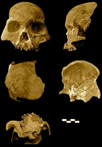
TRINITY COLLEGE DUBLIN, Dublin, Ireland, Dec. 28th, 2015 – A team of geneticists from Trinity College Dublin and archaeologists from Queen’s University Belfast has sequenced the first genomes from ancient Irish humans, and the information buried within is already answering pivotal questions about the origins of Ireland’s people and their culture.
The team sequenced the genome of an early farmer woman, who lived near Belfast some 5,200 years ago, and those of three men from a later period, around 4,000 years ago in the Bronze Age, after the introduction of metalworking. Their landmark results are published today in international journal Proceedings of the National Academy of Sciences, USA.
Ireland has intriguing genetics. It lies at the edge of many European genetic gradients with world maxima for the variants that code for lactose tolerance, the western European Y chromosome type, and several important genetic diseases including one of excessive iron retention, called haemochromatosis.
However, the origins of this heritage are unknown. The only way to discover our genetic past is to sequence genomes directly from ancient people, by embarking on a type of genetic time travel.
Migration has been a hot topic in archaeology. Opinion has been divided on whether the great transitions in the British Isles, from a hunter-gatherer lifestyle to one based on agriculture and later from stone to metal use, were due to local adoption of new ways or whether these influences were derived from influxes of new people.
These ancient Irish genomes each show unequivocal evidence for massive migration. The early farmer has a majority ancestry originating ultimately in the Middle East, where agriculture was invented. The Bronze Age genomes are different again with about a third of their ancestry coming from ancient sources in the Pontic Steppe.
“There was a great wave of genome change that swept into Europe from above the Black Sea into Bronze Age Europe and we now know it washed all the way to the shores of its most westerly island,” said Professor of Population Genetics in Trinity College Dublin, Dan Bradley, who led the study, “and this degree of genetic change invites the possibility of other associated changes, perhaps even the introduction of language ancestral to western Celtic tongues.”
“It is clear that this project has demonstrated what a powerful tool ancient DNA analysis can provide in answering questions which have long perplexed academics regarding the origins of the Irish,” said Dr Eileen Murphy, Senior Lecturer in Osteoarchaeology at Queen’s University Belfast.
Whereas the early farmer had black hair, brown eyes and more resembled southern Europeans, the genetic variants circulating in the three Bronze Age men from Rathlin Island had the most common Irish Y chromosome type, blue eye alleles and the most important variant for the genetic disease, haemochromatosis.
The latter C282Y mutation is so frequent in people of Irish descent that it is sometimes referred to as a Celtic disease. This discovery therefore marks the first identification of an important disease variant in prehistory.
“Genetic affinity is strongest between the Bronze Age genomes and modern Irish, Scottish and Welsh, suggesting establishment of central attributes of the insular Celtic genome some 4,000 years ago,” added PhD Researcher in Genetics at Trinity, Lara Cassidy.
_____________________________________________
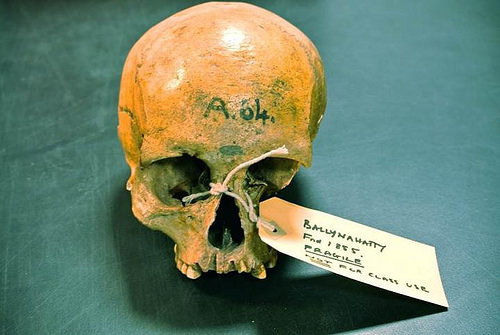
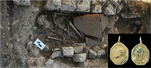
Excavated near Belfast in 1855, the skeleton of the Neolithic early farmer woman had lain in a Neolithic tomb chamber for 5,000 years; subsequently curated in Queens University Belfast. Credit: Daniel Bradley, Trinity College Dublin
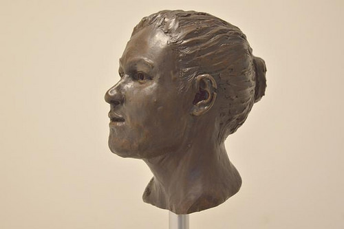
This is a reconstruction of the Neolithic early farmer woman head and face by Elizabeth Black. Her genes tell us she had black hair and brown eyes. Credit: Barrie Hartwell.
This richly illustrated issue includes the following stories: Two remarkable discoveries that are shedding light on human beginnings in Africa; a traveling exhibit and an archaeological site that show how knowledge is more valuable than gold; a Spanish cave and a unique burial that are offering a tantalizing glimpse on the lives of Ice Age hunter-gatherers in Europe; the stunning visual reconstruction of an ancient Roman town; enlightening new finds at a remarkably well-preserved site of ancient Hellenistic-Roman culture overlooking the Sea of Galilee; rare finds that are shedding light on occult practices among ancient Greeks in Sicily; and an overview of the overwhelmingly rich archaeological heritage of Britain. Find it on Amazon.com.
Analysis of the oldest-known cemetery in the South Pacific may help resolve a longstanding debate over the origins and ancestry of Polynesians. Modern-day Polynesians bear strong cultural and linguistic similarities to the ancient people associated with the Lapita Culture who settled on Vanuatu more than 3,000 years ago. However, the origin of the Lapita people remains debated, with recent biological studies suggesting that the group may be of mixed ancestry with a strong contribution from Melanesian populations, who were already established on islands to the west near New Guinea. Frederique Valentin, Matthew Spriggs, and colleagues conducted morphological analyses involving craniometric measurements of skeletons from a roughly 3,000-year-old cemetery at Teouma on the south coast of Vanuatu’s Efate Island. Measurements were taken on five ca. 3,000 to 2,850-year-old skulls recovered from the Teouma site and 270 more skulls from Australia, Melanesia, Western Micronesia, Polynesia, and China. They found that early Lapita remains comport with present-day Polynesian and Asian populations. Later generations, by contrast, begin to exhibit characteristics associated with a Melanesian phenotype.
Combined with archaeological data, their findings* suggest that Lapita settlers in Vanuatu expanded relatively quickly into Polynesia to become the primary contributor to modern Polynesians’ biological make-up. Melanesian migration from previously established areas followed during a time when the early Polynesians were effectively isolated, eventually dominating the original Lapita phenotype, according to the authors.
___________________________________________
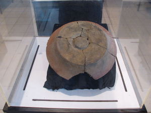
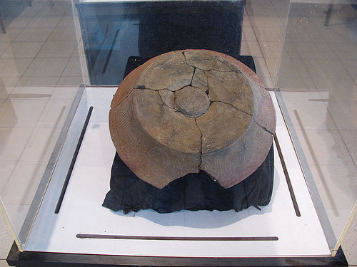
The Lapita are perhaps best known for their distinctive pottery, an example of which is shown here.Torbenbrinker, Wikimedia Commons
*“Early Lapita skeletons from Vanuatu show Polynesian craniofacial shape: Implications for Remote Oceanic settlement and Lapita origins,” by Frédérique Valentin, Florent Détroit, Matthew Spriggs, and Stuart Bedford.
This richly illustrated issue includes the following stories: Two remarkable discoveries that are shedding light on human beginnings in Africa; a traveling exhibit and an archaeological site that show how knowledge is more valuable than gold; a Spanish cave and a unique burial that are offering a tantalizing glimpse on the lives of Ice Age hunter-gatherers in Europe; the stunning visual reconstruction of an ancient Roman town; enlightening new finds at a remarkably well-preserved site of ancient Hellenistic-Roman culture overlooking the Sea of Galilee; rare finds that are shedding light on occult practices among ancient Greeks in Sicily; and an overview of the overwhelmingly rich archaeological heritage of Britain. Find it on Amazon.com.
UNIVERSITY OF CENTRAL FLORIDA—University of Colorado anthropology Professor Arthur A. Joyce and University of Central Florida Associate Professor Sarah Barber found evidence in several Mexican archeological sites that contradict the long-held belief that religion acted to unite early state societies. It often had the opposite effect, the study says.
“It doesn’t matter if we today don’t share particular religious beliefs, but when people in the past acted on their beliefs, those actions could have real, material consequences,” Barber said about the team’s findings. “It really behooves us to acknowledge religion when considering political processes.”
Sounds like sage advice in today’s world that has multiple examples of politics and religion intersecting and resulting in conflict.
The team published its findings “Ensoulment, Entrapment, and Political Centralization: A Comparative Study of Religion and Politics in Later Formative Oaxaca,” after spending several years conducting field research in the lower Río Verde valley of Oaxaca, Mexico’s Pacific coastal lowlands. They compared their results with data from the highland Valley of Oaxaca.
Their study viewed archaeological evidence from 700 B.C. to A.D. 250, a period identified as a time of the emergence of states in the region. In the lower Verde, religious rituals involving offerings and the burial of people in cemeteries at smaller communities created strong ties to the local community that impeded the creation of state institutions.
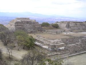
And in the Valley of Oaxaca, elites became central to mediating between their communities and the gods, which eventually triggered conflict with traditional community leaders. It culminated in the emergence of a regional state with its capital at the hilltop city of Monte Albán.
____________________________________________
The archaeological site of Monte Albán. Hajor, Wikimedia Commons
_______________________________________________
“In both the Valley of Oaxaca and the Lower Río Verde Valley, religion was important in the formation and history of early cities and states, but in vastly different ways,” said Joyce, lead author on the study. “Given the role of religion in social life and politics today, that shouldn’t be too surprising.”
The conflict in the lower Río Verde valley is evident in rapid rise and fall of its state institutions. At Río Viejo, the capital of the lower Verde state, people had built massive temples by AD 100. Yet these impressive, labor-intensive buildings, along with many towns throughout the valley, were abandoned a little over a century later.
“An innovative aspect of our research is to view the burials of ancestors and ceremonial offerings in the lower Verde as essential to these ancient communities,” said Joyce, whose research focuses on both political life and ecology in ancient Mesoamerica. “Such a perspective is also more consistent with the worldviews of the Native Americans that lived there.”
_____________________________________________
Associate Professor Sarah Barber found evidence in several Mexican archeological sites that contradict the long-held belief that religion acted to unite early state societies. It often had the opposite effect, the study says. Credit: UCF: Nick Russet
This richly illustrated issue includes the following stories: Two remarkable discoveries that are shedding light on human beginnings in Africa; a traveling exhibit and an archaeological site that show how knowledge is more valuable than gold; a Spanish cave and a unique burial that are offering a tantalizing glimpse on the lives of Ice Age hunter-gatherers in Europe; the stunning visual reconstruction of an ancient Roman town; enlightening new finds at a remarkably well-preserved site of ancient Hellenistic-Roman culture overlooking the Sea of Galilee; rare finds that are shedding light on occult practices among ancient Greeks in Sicily; and an overview of the overwhelmingly rich archaeological heritage of Britain. Find it on Amazon.com.
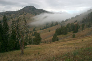
Something else other than the rise of agriculture spurred the accelerated growth in human population sizes that in turn gave rise to urbanized civilization. At least, so suggests a recent study* conducted by H. Jabran Zahid of the Smithsonian Astrophysical Observatory, and his colleagues from the University of Wyoming, the results of which are published in the Proceedings of the National Academy of Sciences.
Using a statistical analysis of radiocarbon dates, the researchers estimated the long-term population growth rate for foraging societies in Wyoming and Colorado during the period 6,000-13,000 years ago, and found that the growth rate is comparable to growth rates previously determined for contemporaneous farming societies in Europe. It is a growth rate that supports the suggestion that the introduction of agriculture was not directly related to the long-term annual rate of population growth that so many scholars have traditionally theorized. The results are also consistent with recent genetic studies that have shown that worldwide human population expansion actually occurred before the advent of agriculture, during prehistoric times. The sudy authors report that the same rate of growth occurred across differentiating environments, suggesting that human populations successfully adapted to their environments and that population expansion may have occurred based on other factors, such as global climate change or endogenous biological factors.
_____________________________________________
A scene in Wyoming. Greg Willis, Wikimedia Commons
This richly illustrated issue includes the following stories: Two remarkable discoveries that are shedding light on human beginnings in Africa; a traveling exhibit and an archaeological site that show how knowledge is more valuable than gold; a Spanish cave and a unique burial that are offering a tantalizing glimpse on the lives of Ice Age hunter-gatherers in Europe; the stunning visual reconstruction of an ancient Roman town; enlightening new finds at a remarkably well-preserved site of ancient Hellenistic-Roman culture overlooking the Sea of Galilee; rare finds that are shedding light on occult practices among ancient Greeks in Sicily; and an overview of the overwhelmingly rich archaeological heritage of Britain. Find it on Amazon.com.
ANAPA, DECEMBER, 2015 – The Volnoe Delo Oleg Deripaska Foundation, one of the largest private charities in Russia, has announced that Russian archaeologists working at the site of the ancient Greek city of Phanagoria near the Black Sea have discovered traces of a violent coup at the site, which at one time was the capital of the Kingdom of Bosporus in the 5th-4th century BC.
Following the Foundation-supported 12th archaeological season at the site of ancient Phanagoria, archaeologists reached ancient layers dating back to the 6th-5th century BC. They unearthed fragments of a city destroyed by a massive fire in 480-470 BC. It matches historic chronicles about power transition in the Kingdom of Bosporus when a Thracian dynasty of Spartocids deposed the ruling Archaeanactids dynasty in the 5th century BC.
The discovery suggests that the ruling dynasty’s takeover was accompanied by violent clashes that destroyed the entire city. Archaeologists will conduct a more thorough study of the city’s remains next year, as the recent archaeological season at Phanagoria was marred by heavy rains that hindered access to the finds. Among the recent discoveries thus far, however, are remains of a two-room sun-dried earth brick building dated to the 6th century BC. If the further studies confirm it was part of an acropolis, it will be the most ancient shrine found on modern Russian territory.
_________________________________________
Archaeologists excavating at Phanagoria’s eastern acropolis. Courtesy Volnoe Delo Oleg Deripaska Foundation
Among other finds in 2015 is evidence that supports the accounts of the city’s fall in the 10th century when the residents abandoned the area for unknown reasons. Archaeological finds, together with historic documents now confirm that Phanagoria was one of the main cities of Khazar Kaganate in the 10th century A.D., and that it was besieged by the Slavic warlord Helgu (often interpreted as Oleg) who was known as a diplomatic invader. He was believed to have forced locals to flee the city in exchange for immunity.
____________________________________________
The Khazar layers at Phanagoria. Courtesy Volnoe Delo Oleg Deripaska Foundation
The site of Phanagoria is known to have yielded a rich array of rare historic artifacts. Among them is an ancient naval ram used by the army of Mithradates VI of the Bosporan Kingdom to quell a popular uprising against him in 63 BC, as well as a palace of Mithradates VI dated to the 1st century BC, an ancient tomb with a stepped ceiling, the oldest temple unearthed on Russian territory dating back to the 5th century BC, and a number of submerged objects, e.g., the ancient city’s streets covered with sand, Phanagoria’s port structures, and ship debris.
The history of the site goes back to the time when it was first established as a colony by the Milesian Greeks in the 7th and 6th centuries B.C.
Says Vladimir Kuznetsov, the head of the Phanagoria expedition:
“One of the main results of the Phanagoria fieldwork this year is the hypothesis about possible reasons for the residents’ exodus in the 10th century. Phanagoria studies allow us to tie the history of the Byzantine Empire, Khazar Kaganate and Ancient Rus together. We can see that the emerging Old Russian state had a strong political and social influence in the region. As for the ancient cultural layers, we possess unique historical artifacts that have no analogues in the world. We’re currently working with 6th-5th century BC layers covering 1,000 sq.m, so the new finds are to follow.”
Adapted and edited from the subject Basic Element press release.
This richly illustrated issue includes the following stories: Two remarkable discoveries that are shedding light on human beginnings in Africa; a traveling exhibit and an archaeological site that show how knowledge is more valuable than gold; a Spanish cave and a unique burial that are offering a tantalizing glimpse on the lives of Ice Age hunter-gatherers in Europe; the stunning visual reconstruction of an ancient Roman town; enlightening new finds at a remarkably well-preserved site of ancient Hellenistic-Roman culture overlooking the Sea of Galilee; rare finds that are shedding light on occult practices among ancient Greeks in Sicily; and an overview of the overwhelmingly rich archaeological heritage of Britain. Find it on Amazon.com.
Matthew Notarian is Visiting Assistant Professor of Classics at Hiram College and a Trench Supervisor with the Upper Sabina Tiberina Project. He received his Ph.D. and M.A. in Classics from the University at Buffalo, specializing in Roman archaeology. He also holds a B.A. from the University of Delaware. He has been a fellow of the American Academy in Rome and an exchange fellow of the Scuola Normale Superiore in Pisa. Previously, he taught at Tulane University and Johns Hopkins University, and has participated in fieldwork at several sites in Italy and Greece.
According to the well-known myth, the fledgling city of Rome, founded in 753 BC, began with a potentially fatal flaw. By opening up its gates to runaway slaves, criminals, and exiles, Romulus had succeeded in attracting men to his newly established settlement. But it lacked women, and these less than ideal bachelors understandably had trouble attracting brides. The Romans invited their northern neighbors, the Sabines, to a festival, only to kidnap their young women, who became the first Romans’ wives. Not surprisingly, war followed, but the ensuing peace saw a dual kingship for the new city: Romulus and Titus Tatius, the Sabine leader. The city would never have survived beyond a single generation were it not for these events, leading the Romans to value a special connection to the Sabine people – two nations united by blood from the very beginning.
The historical record, however, challenges this unlikely story. In reality, the Sabines were only definitively conquered by the growing Roman state in 290 BC under the general Manius Curius Dentatus. Undoubtedly, some of their land was confiscated and given to Roman veteran soldiers, a practice in keeping with Roman conquest. It was also at that time that the Romans awarded the defeated Sabines partial Roman citizenship (that is, without the right to vote in Rome’s elections). However, only a couple of decades later, in 268 BC, the Sabines were given full Roman citizenship, a groundbreaking concession for a non-Latin-speaking people. From this date forward, the Sabines and the Romans did enjoy something of the close affinity expressed in myth and legend. Several aristocratic Roman families claimed Sabine descent, such as the Claudii, whose members included the emperors Tiberius, Caligula, Claudius, and Nero. The founder of Rome’s second imperial dynasty, Vespasian, also hailed from Sabine country, bringing to the throne his ancestors’ characteristic austerity, hardiness, and no-nonsense approach to governance.
Nevertheless, the historical account of the conquest of the Sabines and their territory (called Sabinum by the Romans) leaves many questions about the impact of this event unanswered. For example: How did this political shift affect settlement patterns in Sabine territory? Can we detect the settlement of Roman soldiers and citizens in the territory by examining the archaeological record? How did this major restructuring of the relationship between the Romans and Sabines affect the economic ties between Sabinum and the city of Rome?
Since 2011, an archaeological endeavor, the Upper Sabina Tiberina Project (UST), operated under the auspices of Rutgers University, has sought to shed light on the long-term effects of the Roman conquest in one portion of the Sabines’ homeland.
The Sabina Tiberina
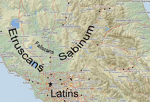
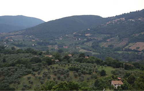
Today, the territory that encompassed ancient Sabinum is an area to the northeast of Rome called the Sabina (Fig. 1). It is a somewhat fluid region that spans parts of the modern regions of Lazio, Umbria, and Abruzzo. The Sabina is a hilly country, mainly given over to olive groves and dotted by picturesque medieval hill towns (Fig. 2). The uneven terrain makes for a meandering network of roads full of switchbacks that renders even modern car travel surprisingly time consuming (and nauseating to the weak of stomach). As a whole, the Sabina is divided roughly in half by the Sabine mountains, a formidable range running south to north that forms the foothills of the Apennines. The western boundary of Sabine country is the Tiber River and its valley (the opposite bank was the land of the Etruscans and the Faliscans, other rivals of early Rome), and this is what gives the western Sabina its name of Sabina Tiberina.
Unlike the Etruscan/Faliscan west bank of the Tiber, which has been extensively studied by archaeologists since the 1950s, the Sabine east bank has received considerably less attention. This is a surprising oversight given the importance of the river for trade with the city of Rome, a massive market with a million residents at its peak. The Tiber was the principal artery that gave the Romans access to central Italy. Moving goods over water was considerably cheaper and faster (especially downriver, as in this case) than overland travel in the ancient world. As a result, the Sabina Tiberina was an extremely valuable addition to Roman territory. Exploiting the fertile agricultural land closest to the river would have allowed Roman landowners to become very wealthy. It was also close enough to the capital that they could have reached their country estates in no more than a day or two’s travel.
One reason for the relative neglect of the Sabina Tiberina by archaeologists may lie in the region’s lack of urbanization in ancient times. While the Etruscans and Faliscans had developed an urbanized society with competing city-states (not unlike Rome and its other Latin speaking neighbors), the Sabines remained a more dispersed and rural people with few large cities. Enticed by rich settlements and a more forgiving terrain of rolling hills covered by plowed fields, generations of archaeologists systemically studied the west bank. On the other hand, the Sabina Tiberina, with its undulating, hilly terrain, makes archaeological survey (the systematic walking of agricultural fields in search of surface artifacts) difficult, if not impossible. This is not to say, however, that the east bank does not offer anything of historical interest. On the contrary, recent research on the Sabina Tiberina has suggested that the east bank of the Tiber may have been more heavily exploited than previously assumed, and many of its archaeological sites have yet to be studied using modern survey and excavation techniques.
The study area of the UST project (the ‘upper’ Sabina Tiberina) is its northern half, where the least amount of previous research has been carried out. The area had only one Roman town, Forum Novum, founded by the Romans at some point after the conquest in the early 3rd century BC in order to provide a market center for the dispersed estates of the region. By the 1st century AD, the town had been elevated to the status of a “true” Roman town (municipium in Latin), although research conducted by the British School at Rome in the early 2000s revealed that the town consisted of little more than a few public buildings and a nearby villa. However, what the region lacks in Roman urban culture is more than made up by a network of Roman villas – elite country residences connected to large agricultural estates.
______________________________________________
Fig. 1:Central Italy at the time of the Roman Empire, indicating the location of Sabinum and neighboring peoples. (Adapted from Pelagios Project)
The word ‘villa’ still brings to mind an image of a luxurious residence, and its ancient counterpart was a very distinctive type of lavish structure. Villas were arguably one of the most characteristic features of Roman culture, and one that spread across the Mediterranean and Western Europe with the expansion of Roman power. While many still debate the exact origins of this institution, it is clear that by the 1st century BC a wealthy Roman would likely have owned several of these types of residences across the Italian peninsula. In fact, it was a necessity for the ruling class – both socially and economically.
By definition, a villa was located in the countryside and it defined the center of a large agricultural estate. Since the landowners did not live in these properties year round, the residence served as a kind of country vacation home for the elite, but with all the comforts of city life. Villas were usually paved with mosaic floors and decorated with wall paintings and sculptures. Private bath complexes, decorative fountains, and formally planted gardens provided a suitable setting for a Roman aristocrat to devote himself to leisure, free from the pressures of political life in Rome. Yet central to the villa was a working farm. Land was the primary, and only socially acceptable, source of wealth for the aristocracy in the Roman world. Tended by slaves or tenants in the owner’s absence, these estates typically specialized in cash crops that were guaranteed to bring in a good return. These included olives, grapes (for wine), and even small game or other edible luxuries favored by the upper classes, such as snails, fish, and small birds. True Roman aristocrats owned several properties around Italy, diversifying against the risk of localized drought or disease. They made a habit of visiting each in turn throughout the year. The excuse was to check on farms and staff, but the true payoff was the opportunity to relax by hunting, reading, writing, and enjoying the pleasant setting of the estate.
The Sabina Tiberina, like much of the Italian countryside, was home to at least several dozen Roman villas. Many of these have been known for centuries due to their visible ruins dotting the hillsides and valleys of the region. Most were built with foundations of Roman concrete, which, by virtue of its durability, today leaves telltale masses of structural remains. Other villas were found when plows or other agricultural activity churned up large concentrations of broken pottery and roof tiles. A small number of sites even produced works of sculpture in earlier centuries. Very few, however, have ever been studied by professional archaeologists. One villa, located near the town of Cottanello, was extensively excavated in the 1960s by a group of amateur archaeologists. Only in the last few years have experts from the University of Rome “La Sapienza” returned to the site. Another villa, near the town of Forum Novum, was briefly explored with a few test trenches by British archaeologists over a decade ago. Outside of these two examples, no other villa in the region has ever been investigated by specialists.
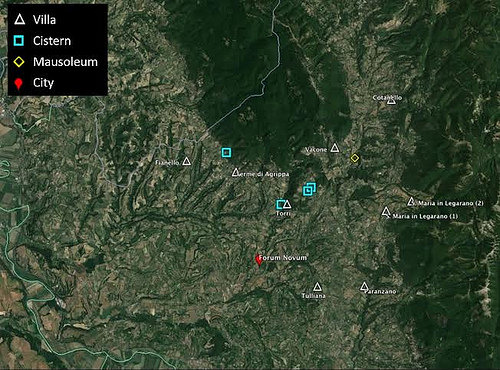
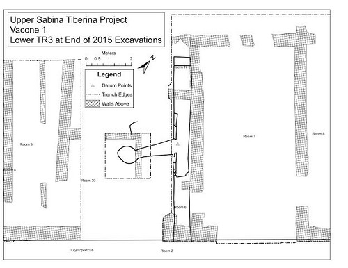
The UST project has identified at least 15 villas of interest in the research zone (Fig. 3). One of the goals of the project is to study a select number of these sites using geophysical survey techniques – tools that require no digging to gain information about what is underground. These include ground penetrating radar, as well as magnetometry, a method that measures magnetic fields beneath the earth’s surface in order to discern significant anomalies, such as walls or voids. While the results are largely dependent upon local conditions, in the best case scenario they can provide plans of structures that are still underground. Nonetheless, in order to gain a more complete picture of a villa, such as a detailed understanding of its date and how it changed through time, there is no better technique than old-fashioned excavation. For this reason the UST project chose one particular villa in the region as the focus of intensive investigations – the villa at Vacone.
Fig. 3: Study area of the UST Project indicating sites of interest. The presence of cisterns often indicates a nearby villa, making these sites worthy of further investigation. (Map Data: Google, TerraMetrics).
The town of Vacone is located about 55 km north of Rome, perched on the slope of Monte Cosce, a formidable mountain that marks the border between the modern regions of Lazio and Umbria (Fig. 2). It is a very small town with fewer than 300 permanent residents, but the people of Vacone have a strong sense of their place in history. Every June, they observe the “Sacra Vacunae”, a festival that re-imagines the ancient Sabines’ celebration of their goddess Vacuna. Tradition holds that the town’s name derives from the name of the Sabine deity, whose temple sits beneath Vacone’s central church. While no definitive proof exists of a pagan shrine beneath the church, a few kilometers downhill stand the unmistakable ruins of a Roman villa.
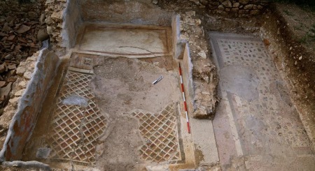
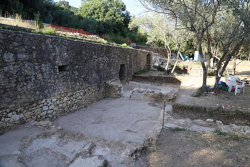
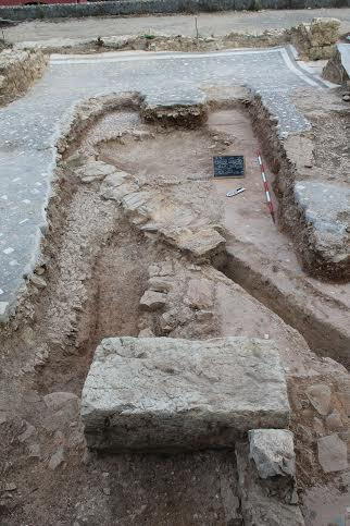
Although known to travelers in the 18th century and earlier, the ruins of the villa were forgotten and only rediscovered in the 1960’s during road construction. Work crews stumbled upon the imposing remains of a vaulted structure called a cryptoporticus, built of Roman concrete and large blocks of local limestone, as well as a semicircular structure with a vaulted ceiling (Fig. 4). Further investigation revealed a second cryptoporticus just downhill from the first. Both could be entered through doorways and formed a kind of covered passageway. Such features are not uncommon in the architecture of Roman villas. However, these two particular structures formed the supports for a wide terrace upon which rests the main residential zone of the villa (Fig. 5). By the mid 1980s the cryptoportici were in need of repair, and a series of conservation efforts carried out by the Italian government shored up the remains. This work also uncovered one section of a well-preserved mosaic floor located on the upper surface of the lower cryptoporticus. This was removed and placed into storage, where it remains today.
As the UST project was getting underway in 2011, the Vacone villa was chosen for excavation for a number of reasons. First, the earlier work of the Italian government had exposed a series of doorways just to the north of the lower cryptoporticus. This strongly suggested that a series of rooms, possibly also paved by mosaics, lay waiting to be discovered to the north. Second, above the upper cryptoporticus were the remains of vats, channels, and a circular feature in the ground that surely belonged to a press for olive oil. Most importantly, the construction technique of the cryptoporticus wall, concrete mixed with rough large stones, suggested an early date, perhaps the 2nd c. BC or earlier. This would place the initial construction of the villa in the period not long after the Roman conquest of Sabinum, perhaps shedding light on the processes set in motion by this event. Therefore, the Vacone villa offers the possibility of examining several interesting facets of the Sabina Tiberina and its place in the study of Roman imperialism, the Roman economy, and, more generally, Roman society and culture.
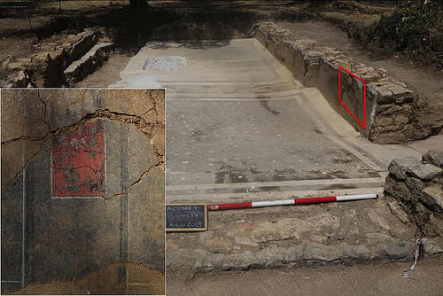
Fig. 4: Upper cryptoporticus viewed from west. In the foreground is Room 12, paved in cocciopesto, which likely served as a storage area. (UST Project Photo)
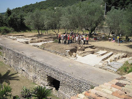
Fig. 5: Overall view of the villa from the south with the 2013 field crew. Both the lower and upper cryptoportici are visible. Note the clearly visible reconstructed sections in the lower structure. (UST Project Photo)
To date, four seasons of fieldwork have been carried out at Vacone. Every summer, undergraduate and graduate students from the United States and the U.K. come to Vacone to learn proper archaeological methodology while furthering the research goals of the UST project. They join an international staff that comes from Italy, the United States, U.K, and Australia. Many local residents of Vacone also generously volunteer their time and resources to help advance the study of this invaluable piece of Roman heritage.
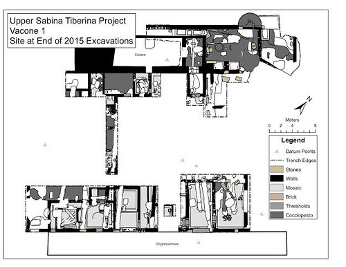
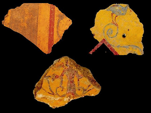
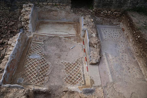
At the end of the 2015 season, excavations had uncovered evidence of at least 32 distinct rooms, although some of these remain only partially excavated (Fig. 6). The vast majority of these rooms belong to the residential sector of the villa, as evidenced by the presence of mosaic floors and painted wall plaster in most of these rooms. The plaster is generally only preserved for a few centimeters along the walls, but hundreds, if not thousands, of fragments have been recovered and are awaiting study. Most walls were colored with red, black or yellow backgrounds and accompanied by a variety of designs, such as an unusual ring pattern not known from other sites, or another fragment containing a bird and plantlike motifs (Fig. 7). A particularly well-preserved section still in place on the east wall of Room 4, with an intricate geometric and floral design in black and red, provides a hint of the types of schemes that many of the villa’s walls once contained (Fig. 8). Other rooms of the villa also produced examples of molded stucco that once adorned the walls and ceilings.
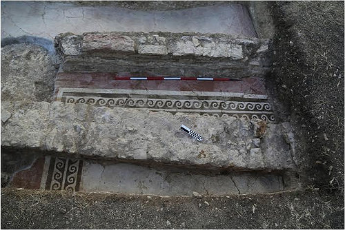
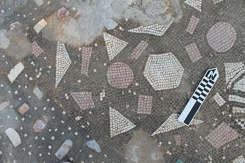
Many of the mosaics, on the other hand, are in good condition and are among the most noteworthy aspects of the villa. All are geometric in design and typically consist of black, white, and red tesserae – the small cubed stones that make up a mosaic floor. The red stones, quite rare in Roman mosaics in general, come from a quarry in the neighboring town of Cottanello. A few mosaics of higher quality contain multiple colors arranged in intricate designs, some even mimicking shaded perspective. For example, the mosaics of Rooms 10 and 4 both include border zones with complex shaded designs of triangles and diamonds in green, red, white, and black (Figs. 8 and 9). The border zone in Room 10 may have originally marked off a niche where a bed, either for sleeping or dining, may have once stood. Other notable mosaic designs in the villa include a double wave (Fig. 10) and checkerboard pattern, as well as a few variations on a net motif. Several rooms also contain mosaics of the type called opus scutulatum, which consists of a series of larger colored stones set into a background of single colored tesserae (white or black) or other types of plain pavement. Especially remarkable in the Vacone villa is ample evidence of repairs made to the mosaic floors in ancient times. In Room 8, for example, a large area of damage to an opus scutulatum was replaced in antiquity by red or white tesserae arranged to mimic the lost colored stones of the pattern (Fig. 11). Repairs to the mosaic are also evident in Room 10. In other rooms, mosaic floors that became damaged in ancient times were simply covered over by simpler paving techniques, such as cocciopesto (a pavement made of mortar and crushed ceramics). The buckling of the floors in several areas hints at structural issues in the villa’s design that may have possibly led to the villa’s eventual abandonment.
Not every room in the villa was paved with mosaics, however. Some rooms seem to have been used for storage or more utilitarian purposes. These areas produced a rich assortment of artifacts and were paved with more utilitarian flooring techniques, such as plain concrete, opus spicatum (a pavement made of bricks arranged in a herringbone pattern) and cocciopesto. For example, room 12, located adjacent to the upper cryptoporticus wall and paved in cocciopesto, produced over 3000 ceramic sherds, mainly cookware and storage containers (Fig. 4). Also noteworthy was an iron key and the remains of a bronze locking mechanism, probably from a storage chest (Fig. 12).
The main agricultural zone was located in the northeastern zone of the villa, beside the upper cryptoporticus. Excavation has revealed many more details about this area, including evidence for not just one, but at least two olive presses (Fig. 13). Once pressed, the olive oil ran along brick lined channels to a series of three vats that could be opened and closed to control the flow of oil (Fig. 14). These vats were used to separate the oil from the amurca, the watery byproduct of olive pressing. Another channel reveals how the liquid in the vats could be drained into the upper cryptoporticus, for reasons still under investigation. Preliminary research suggests that the presence of two presses puts the Vacone villa in rare company, with fewer than 30 other villas in the region of Lazio out of a total of over 300. At the very end of last season, we also discovered a basin for collecting juice from a grape-treading floor, not far from the pressing area. While further exploration is needed, this may hint at a shift from olive to wine production during the course of the villa’s occupation.
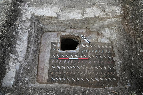
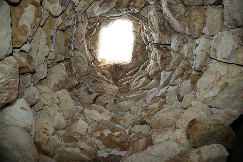
The villa has also produced a few surprises. During the second season of digging, a small void opened up during excavation near the corner of one of the villa’s largest rooms, Room 7. Two seasons of careful excavation in cramped conditions have revealed that this was a vaulted passageway leading to the lower level of the villa and the interior of the cryptoporticus below (Figs. 15 and 16). It had a floor of beaten earth and was full of broken pottery, including several lamps, a necessity in this gloomy underground section of the villa. This past summer, a secondary passageway was identified, opening perpendicularly to the original tunnel, that leads into a circular vaulted chamber. A two by two meter test trench centered on the midpoint of the round chamber was excavated to see what architecture corresponded to this feature on the ground level of the villa. This revealed a stone with a cut opening that sits directly atop the capstone of the vaulted chamber below (Figs. 17 and 18). This feature has defied early attempts to understand its function. The opening brings to mind a latrine or wellhead for a cistern, but its placement and surrounding architecture do not support these interpretations. Future excavation within the circular chamber will hopefully shed light on this mysterious feature. Furthermore, additional passageways or collapsed underground vaults were discovered last summer in the western end of the villa. Several floors of the villa also produce a distinctive (and disconcerting) hollow sound when struck. This suggests that more of the terrace may be artificially constructed than previously assumed. If so, there may be far more to be investigated in the underground spaces of the villa.
Finally, four seasons of fieldwork have finally begun to provide some indications of the villa’s chronology. Much of the evidence for the earlier phases of the villa came to light due to damage the villa sustained during agricultural work in later centuries. All across the site, deep trenches were dug, possibly for vines, that cut through the mosaic floors of the villa in several areas. Excavating within these cuts allowed us to gain windows into what lies beneath the villa’s mosaic floors, which probably date to the 1st or 2nd centuries AD. For example, beneath the floor of Room 3 we found an earlier floor in opus scutulatum, but paved with cocciopesto rather than the mosaic background of later floors in the villa (Fig. 19). Ceramic evidence currently suggests a date around 100 BC for this earlier phase of the villa, but future study will refine our knowledge of the villa’s initial construction.
On the other end of the villa’s history, we are also beginning to understand how the villa came to be abandoned. At some point, new walls were constructed along a different orientation from the walls of the imperial era villa. Many of these new walls were built through the mosaic floors of the 1st or 2nd century AD, indicating their later date (Fig. 10). At an unknown subsequent date, the rooms of the villa also came to be used for human burials. So far, six individuals have been found. Four were male adults in their 30s, one was a young child of indeterminate sex, and the last was a newborn, found within a drain inside the upper cryptoporticus. The only indication of when these individuals were buried comes from a medallion dating to 1700 discovered near one of the adult burials (Fig. 20). However, since there is clear evidence that the bones were disturbed after the initial burial, it could suggest a date when the remains were reinterred rather than the date of the original interment. As for when the villa was abandoned, preliminary evidence suggests the villa may have gone out of use as early as 200 AD. For instance, of the several coins that we have discovered on the site, the latest datable examples are from the 2nd century AD, and many were found on the surface of the latest floors, mixed in with the collapse of the structure. The same holds true for the diagnostic pottery found on site – no forms date later than about 200 AD.
Fig. 9: Rooms 10 (left) and 20 (right) viewed from the south. The mosaic pattern of Room 10 likely indicates a niche where a bed was located in the far end of the room. A repaired section is also visible in the border zone. Room 20 preserves the opus scutulatum design. (UST Project Photo)
Fig. 11: Detail of repair to an opus scutulatum mosaic in Room 8. Note how the repairman recreated the colored stones of the original using mosaic tesserae. (UST Project Photo)
Fig. 13: Pressing area viewed from the southwest. The circular pressing beds and channels for oil have been highlighted in black. In the background are the remains of a semicircular vaulted structure that was once a full dome. It may have belonged to a bath complex, but was later converted to agricultural use. (UST Project Photo)
Fig. 14: Vats for collecting olive oil, viewed from the east. Note the channel running along the right side of the vats, which leads from the presses. The flow of oil could be controlled by blocking openings into each of the vats. (UST Project Photo)
Fig. 16: Plan of southeastern section of villa indicating lower level passageways. The hatched areas indicate walls on the surface, while solid lines display underground tunnels. Note the side passage that opens into a circular vaulted chamber below Room 30. (UST Project)
Fig. 17: Room 30 with an opening into the circular chamber below, viewed from the west. The layout of the mosaic indicates that it was designed around the opening, which could be sealed by a cover, as evidenced by a lip carved around its interior. (UST Project Photo)
Fig. 19: Room 8 viewed from the north. The newer mosaic pavement (opus scutulatum on a black background) is visible above. The older pavement (opus scutulatum on a cocciopesto background) can be seen at a lower level. A drain was cut through this older floor at the time that the newer floor was created. A large circular cut for an olive tree can be seen in the center of the photo. (UST Project Photo)
Fig. 20: Male adult skeleton discovered in Room 16, covered by a roof tile. In the inset is a bronze medallion found nearby depicting St. Peter and the doorways of basilicas in Rome, celebrating the Jubilee of 1700. (UST Project Photo)
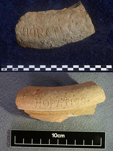
Near the entrance to the site of the Vacone villa is a sign that reads “Villa di Quinto Orazio Flacco” – the villa of Quintus Horatius Flaccus. English speakers know this individual as the Roman poet Horace, famous for the adage carpe diem as well as a rich body of surviving work. One of the most salient details known about Horace’s life was that Maecenas, one of Augustus’ closest confidants and Horace’s personal patron, gave him a “Sabine villa.” This villa and its adjoining estate allowed the poet the space and time to devote himself to his poetry, and for this reason it provides the setting for several of the poet’s works. Generations of antiquarians and scholars have sought the location of Horace’s famous Sabine villa. Of the few clues to the location of Horace’s villa given in his poetry is the detail that it was located “behind the crumbling temple of Vacuna” (Epistles 1.10). As mentioned earlier, tradition holds that the town of Vacone took its name from a supposed temple of Vacuna beneath its central church. As a result, many local residents resolutely believe that the great poet once called their little town home.
Given the lack of evidence for this attribution, the UST project took little notice of this popular local belief. However, two discoveries, brought to light in 2013 and 2014, have given us reason to reassess this attribution, or at least the villa’s fascinating afterlife as “Horace’s villa” (Fig. 21). The first artifact uncovered was the rim of a dolium, a giant storage vessel that was buried in the ground, inscribed with HORATI F. The following year produced the rim of an amphora, an ancient vessel used to transport oil and wine, with the inscription HORATIUS. It is not out of the question that the excavation of a villa might uncover objects inscribed with the name of the villa’s owner. In fact, this very situation occurred at the neighboring villa of Cottanello, where a dolium rim was discovered identifying the owners as the Roman family of the Aurelii Cottae (and hence the namesake of the modern town). However, our initial excitement was quickly tempered by the realization that our inscriptions were not ancient, but fake. The letters were carved with a sharp object into the pottery after they had been fired, unlike genuine inscriptions that tend to be stamped into the wet clay before firing (such as the Cottanello dolium). Furthermore, the shapes of the letters were different than those used by the Romans, and the objects were found near topsoil, in contexts that were disturbed by later agricultural activity.
While it is impossible to give a precise date for this case of forgery, it is tempting to connect these objects to the 18th century. At that time, several travelers’ accounts reveal that sections of the villa were exposed and displayed to visitors as “Horace’s villa”. Some contemporary writers even mention inscriptions on display that “proved” this was the genuine villa of the poet. These inscriptions, one of which still survives to this day, were also counterfeit. Therefore, it is not out of the question that the two inscribed pottery rims date back to this time period. Even if the UST has not accidently uncovered the famous Sabine villa of Horace, it has nonetheless shed new light on the villa’s remarkable afterlife. As to the true identity of the villa’s owner, one can only hope that subsequent seasons will uncover a piece of evidence as telling as the two inscribed rims purport to be.
_________________________________________________
Fig. 21: Upper: Rim of a dolium found in 2013, inscribed HORATI F. Below: Amphora rim found in 2014, inscribed HORATIUS. (UST Project Photo)
For additional information on the Upper Sabina Tiberina Project, or to apply to participate in the excavation at Vacone, please see the project’s webpage at: fieldschool.rutgers.edu.
The Upper Sabina Tiberina Project is directed by Gary D. Farney (Rutgers University-Newark, Project Director), Dylan Bloy (Field Director), Giulia Masci (Site Director, Science Museum-London), Ian Travers (ICOMOS-Australia, Assistant Director for Excavation Operations), Candace Rice (University of Edinburgh, Assistant Director for UST), Tyler Franconi (Oxford University, Assistant Director of Finds), and Kimberly Brown (University of the Arts, Assistant Director for Survey Operations).
Receive 30 days free access to the popular new CuriosityStream lineup of documentaries on science, history, nature, and technology as a new Popular Archaeology premium subscriber.
Mark Hallum is a staff writer for Popular Archaeology Magazine.
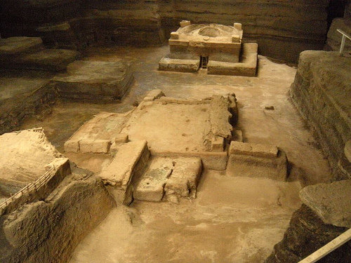
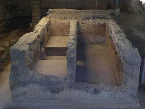
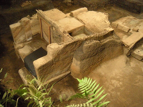
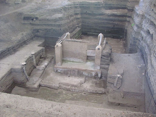
Joya de Cerén, August, 660 A.D.—They knew what to do as soon as they felt the earth tremble.
It was time to get out of town, and quickly.
With not a moment to lose, they gathered what meant most to them—themselves and their families—and fled away as fast as they could. Anyone remaining would have heard the terrifying shrieking sound of the massive steam explosion as the hot magma made contact with the water of the nearby Rio Sucio river, along with the pyroclastic blast that eventually buried the town in a moist, hot volcanic ash.
Within days, where once stood their town amidst a lush green forest and agricultural fields, there was an ash-white desert. They would never return.
Evidence of a Disaster
The forgotten village of Joya de Cerén sits beneath a 17-foot layer of pyroclastic ash, exactly as it was left 1400 years ago in present-day El Salvador during a sudden volcanic eruption from the Loma Caldera volcano, just 600 meters distant. The results of archaeological excavations and research at this site testify to a rapid and desperate departure by the town’s inhabitants soon after their evening meal—tools and religious objects were left unceremoniously and randomly where they were last used, bed mats were left in place, and the fires in the hearths were still dying into embers. It was early August. The harvest was in and people were attending a ritual in one of the community buildings. That summer the farmers had made the decision to grow and harvest manioc, the roots of which are used to make cassava bread. It was feared that a drought might ruin their harvest and that the village would be short on food. Beans and corn fall victim to drought, but the manioc would save them from such desperate conditions. But these plans lost their meaning with the eruption.
For the people of Cerén, it was not the first time their town had been abandoned because of natural disaster. They likely had already heard the stories of a different eruption generations before. Archaeological and geological evidence shows that no earlier than AD 405, the llopongo eruption, centered southeast of present-day San Salvador, had killed an estimated 30,000 people inhabiting a 1000 km area. Around 300,000 people were displaced. Those who repopulated Cerén would surely have told their grandchildren about the devastating event so that by 660 A.D., when the Loma Caldera earthquakes began, the villagers would not waste any time getting out of the way of the onslaught from the pyroclastic blast and the smothering ash.
Cerén, like ancient Pompeii, is an example rarely seen. Nature has made a vivid and detailed impression of life as it was being performed in a moment in time far into the past. In the case of Cerén, cool, fine particles of pyroclastic debris blanketed the community and preserved the forms of thatched roofs, wooden beams, woven baskets and blankets, tools, and adobe structures. Even bean-filled pots, the marks of finger swipes in ceramic bowls, human footprints in gardens and ash casts of corn stalks were left untouched by the effects of time.
Excavations, Manioc, and a Sacbe
Christine Dixon is co-director of the excavations at Cerén, but her career began there nearly a decade ago as a graduate student, assisting in the analysis of Ground-Penetrating Radar scans to identify buried structures. Since completing her Master’s thesis on her experience at Cerén, she has become a leading expert on the day-to-day life of its former inhabitants. But the earliest excavations at Cerén were led by University of Colorado Boulder professor Payson Sheets, who now, along with Dixon, co-directs the excavations. Some of the items he and his team found in a community building included a ceremonial deer headdress, a pot shaped like an alligator, and the bones of a butchered deer. They also recovered the remains of food and animal products. To date, researchers have excavated 12 buildings, including living quarters, storehouses, workshops, kitchens, religious buildings and a community sauna. Dozens of structures remain to be excavated, including the possibility of another settlement or two still buried beneath the Loma Caldera volcanic ash, which covers an area of about two square miles. So far, there have been no human remains recovered.
______________________________________________
Excavations at Cerén in progress. Credit University of Colorado and Christine Dixon
An excavated household (left), storehouse (center) and community sauna (upper right) buried by volcanic ash at Cerén around A.D. 660. Credit University of Colorado
_________________________________________________
A community building at Cerén believed to have been used by elders to make decisions. Note the two large stone benches. Credit University of Colorado
A domestic (house) structure. Structures at Cerén were buried in up to 17 feet of ash over a period of several days, freezing the 1,400-year-old village in time. Credit University of Colorado
From their research, a remarkable picture of the life and activities of the people of Cerén has been reconstructed. Based on the archaeological finds and their spatial relationships they determine that the eruption happened sometime near the end of the day. Moreover, beans had just been planted in the advanced stages of the rainy season so as not to disrupt the growth of maize, which was not yet mature. This would likely have been in early August. This latter finding demonstrates the almost unprecedented volume of information that archaeologists have been able to acquire at Cerén reflecting the details of Maya agricultural production.
“Studying agriculture at Cerén is very important because we have evidence that very rarely preserves in the archaeological record,” says Dixon. The Loma Caldera volcanic eruption deposited fine-grained tephra particles, packing around every object at the site, including the individual plants, in addition to covering entire fields of plants, or crops. When archaeologists arrived at the site 1400 years later, they excavated down through the volcanic ash, encountering hollow spaces where there once had been plants. After mixing and applying dental plaster to the exposed cavities, they then continued excavating the area. “The living surface was also preserved by the volcanic ash,” says Dixon. “Thus, in addition to the plants being in their exact location and form as 1400 years prior, we also see the fields where the plants were growing. We have documented the ridges and agricultural beds and can get an extremely detailed view of how plants were grown, in what types of fields and beds, and the cultivation techniques that were used.” Ancient pollen samples have also been taken, indicating the species of crops grown.
Dixon’s research at Cerén reached new levels when manioc fields were discovered. The pyroclastic debris that buried the village was so fine that it created detailed impressions of the plants, making it easy to distinguish them from maize and to identify their beds. These beds have given archaeologists a rare glimpse of the techniques and methods used for growing the crop. Archaeologists are often required to depend on microscopic data to paint a picture of ancient agriculture, but in this case, Dixon and her team also had convenient renderings in which they could actually ‘see’ the details of ridges and beds.
“Since our initial 2007 discovery of manioc beds at Cerén, portions of four manioc fields have been identified to date, all of which had been harvested just prior to the Loma Caldera eruption,” says Dixon. “It is interesting that all of the manioc plants in these fields were harvested at one time, since manioc begins to rot approximately 24 hours after harvest and thus is typically just left growing in the fields until needed. We hypothesize there was a community effort underway to not only harvest, but then to process all manioc, possibly into a flour or fermented beverage.” Dixon and her associates suggest this because they know that today flour and fermented beverages are made from the root crop. It can also be stored indefinitely, and once it is ground up it can be used as a thickening agent in stews or used to make foods like tamales or tortillas. The flour is known today as “almidon”.
_______________________________________________
Professor Payson Sheets, former doctoral student and co-director Christine Dixon and two Salvadoran workers excavating maize by filling ash hollows left by the plant stalks with dental plaster. Credit University of Colorado
What does the manioc tell us about the Classic Period of Mayan culture? This period is often characterized by periods of drought, one of the reasons cited as a possible cause of the Classic Maya ‘collapse’. Manioc and other root crops are highly resistant to these conditions. Farmers at Cerén growing manioc as opposed to maize and other staple crops may indicate a regular precaution in agricultural communities to safeguard against crop failure. According to Dixon, “Scholars have hypothesized that root crops (specifically manioc) might have been an important part of ancient Maya diets and even agricultural insurance (Bronson 1966); however, the scarcity of direct archaeological evidence for manioc cultivation has greatly limited our understanding of the presence and uses of manioc in the past”……..until now. Sheets calculated that the manioc fields at Cerén would have produced about 10 metric tons of manioc every season. The village was not estimated to have had more than 200 inhabitants—not a large enough population to have consumed that much manioc. What were their reasons for producing so much of this die-hard and versatile crop? Perhaps the excess went to surrounding communities, or to the city center, fulfilling the villager’s obligation to the elite. Or perhaps the community kept it for themselves.
An unexpected feature discovered at the site was the sacbe, or road. This would have been constructed over a period of time. Archaeologists suggest from their analysis of archaeological remains that a variety of families would have contributed to building the sacbe—evidence of individuals who would have overseen the construction and maintenance of the road has been found within the preserved dwellings. “We have yet to locate the end of the sacbe either within the site center or to the south, but have learned a great deal about how it was constructed and where it was located,” says Dixon. “It appears multiple sections were likely built by different groups, possibly different families, and that it was a coordinated effort since the road all slopes in the same direction, which would control the water run off.”
Measurements taken by a penetrometer indicated the sacbe was very hard. Archaeologists suggest that this characteristic was in part achieved by the ancient villagers compacting it by pounding sections of the sacbe with heavy objects. This was enhanced by their use of tephra, the angular grains of which could lock together in a tight matrix when compressed under moist conditions. Exposed sections of the sacbe showed that it was slightly grooved, a likely result of people walking single file as they traveled to their fields or the nearby town of San Andres, suggest Sheets and Dixon.
“The western canal of the sacbe was crisp and well formed and had apparently been worked on just days before the eruption,” said Sheets. “But it looks like the workers hadn’t got around to maintaining the eastern canal before the volcanic event.”
So far, several dozen footprints on the sacbe’s outer, softer edges have been revealed. “More than half of the footprints were headed south away from the village, away from the danger,” Sheets said. “I think at least some of them were left by people fleeing the eruption.”
_________________________________________________
Payson Sheets, right, confers with Salvadoran workers digging a test pit down to an ancient white road called a sacbe running in and out of the ancient village of Cerén. The sacbe is buried under 16 feet of volcanic ash. Credit University of Colorado
Above and below: Views of the Cerén sacbe buried under about 16 feet of ash. The trenches were drainage canals to catch excess rainwater. Credit University of Colorado
Professor Payson Sheets points to the imprint of several toes from a footprint left on the Cerén sacbe. Footprints pointed away from village and may have been made by Mayans fleeing the volcanic eruption. Credit Rachel Egan, University of Colorado
The ancient Maya have been typically depicted as a people ruled by royal elites wielding power and authority from their great monumental ceremonial centers, exacting tribute and controlling affairs much like many other “top-down” societies, where the elite class made most political and economic decisions. But at Cerén, based on Sheets’ and Dixon’s archaeological analysis, the villagers appear to have had significant independence regarding their architecture, crop choices, religious activities and economics. It could have implications for Maya town and village life generally.
“This is the first clear window anyone has had on the daily activities and the quality of life of Maya commoners back then,” said Sheets. “At Cerén we found virtually no influence and certainly no control by the elites.”
Instead, according to Sheets and Dixon, it appears that much power seems to have been vested collectively within the local community. They cite evidence that indicates the residents of particular households at Cerén were responsible for the upkeep of certain community structures, and other households responsible for other specialized activities. One household, for example, contained an inordinate amount of pots and firewood that the researchers speculated were used during activities in a local domed community sauna building. On the larger scale, how the people were organized and directed can also be seen in the style in which the harvest was decided upon and collected, including the layout of the roads. According to Dixon, “From the Cerén agricultural fields it is possible to question how fields were divided, the degree of control farmers had over crop choice and cultivation techniques, and the social and political forces involved……..Our analysis of the buildings, the sacbe, and agricultural fields all suggest that decisions were being made for the community, by the community, rather than imposed upon them by a larger regional force……there was a shared [local] governance at the site, possibility by community elders or a group of community leaders.”
Nevertheless, the archaeologists have deduced a relationship between the Cerén commoners and the Maya elite. It is reflected in the evidence related to public marketplace transactions. Cerén farmers likely traded surplus crops or crafts for coveted, high-end specialty items such as jade axes, obsidian knives and colorfully decorated polychrome pots, items the elites probably arranged to transport to the local market locations from a distance. This, according to the archaeologists, is evidenced in findings that indicated every Cerén household possessing a jade axe—a tool effective for tree cutting, building and woodworking. But even here, it appeared that the community had power and independence. “The Cerén people could have chosen to do business at about a dozen different marketplaces in the region,” said Sheets. “If they thought the elites were ‘charging’ too much at one marketplace, they were free to vote with their feet and go to another.”
“The Cerén community was no doubt in contact with and had a direct relationship with the much larger and more powerful regional centers in the area, like San Andres,” Dixon adds, “but it appears these data suggest that the Cerenians maintained a degree of autonomy and control over their own lives and daily activities.”
_________________________________________________
A polychrome pot unearthed at Cerén. Such pots were prized by the villagers and had likely been obtained through trade at local marketplaces in the valley. Credit University of Colorado
As with most archaeological projects, the process of study and research could go on for years, and there is still work left to do in terms of excavation and investigation at the site location and its regional context.
“We hope to continue working on documenting how this road articulates with the site center, to examine a key central structure that is likely associated with the road, and to have an opportunity to advance conservation of the building and artifacts at the site,” says Dixon.
Most significantly, Sheets, Dixon and colleagues believe that Cerén is opening a vital window toward understanding ancient Maya life at the village level, an aspect of the Maya that has long missed the limelight due at least in part to the popular focus on the Maya royalty and elite.
A paper on the work at Cerén has been published in Latin American Antiquity, a publication of the Society for American Archaeology. The Cerén research area was declared a UNESCO World Heritage Site in 1993.
_______________________________________________
A few words from Christine Dixon
Dr Sheets is the central person who has propelled and carried the research of Cerén from its discovery to the present. Under his careful leadership and enthusiastic direction, there have been many successful projects over the past three decades of research that would not have been possible without his extraordinary efforts.
There are many individuals who have helped on this project before my arrival, such as Dr. Linda Brown, Dr. Rae Beaubien, Dr. Brian McKee, Dr. Andrea Gerstle, Dr. Scott Simmons, Dr. Inga Calvin, Dr. Stacy Barber, and many others.
My involvement in the site began in 2005 and in that time we have had some terrific teams of researchers aid in our excavations and analyses.
Dr. David Lentz has been a key project member, who helped to co-author multiple grant proposals and had led the paleobotanical analysis side of the project. Dr. Lentz is a renowned expert on the study of ancient plants in Mesoamerica and his work and the work of graduate students Venicia Slotten, Angie Hood, and Christine Hoffer have drastically expanded our knowledge of the huge variety of different plants being used at the site. Each of these students have written master’s theses on their examinations of the paleobotanical remains at the site.
Roberta Gallardo has served as a key project participant and liaison for many years and has facilitated our work at the site.
Our research at the site has included the work of many graduate students. Alexandria Halmbacher has been a terrific project member who has participated in multiple field seasons. Her MA thesis examined the storage practices at Cerén in a careful re-examination of the data from household excavations at the site. Rocio Herrera has been a keymember of our research team.
Celine Lamb is a doctoral student at the University of Kentucky and her Master’s thesis was an analysis of the gardens of Cerén households. Theresa Heindel is currently a doctoral student at the University of California, Riverside and her Master’s research examined the role of malanga at Cerén and in Mesoamerica.
Rachel Egan has also participated in research at the site and is a current doctoral student at the University of Colorado, Boulder whose dissertation research is focused on the Ilopango eruption in El Salvador. Other graduate students who have been involved in our research include: George Maloof, Andy Tetlow, Adam Blanford, Dr. Errin Weller, Monica Guerra, and Joya Tetreault.
Additionally, we have been fortunate to have Dr. Nancy Gonlin join us for the portion of a field season and offer key insight as a consultant on the project. University of Colorado, Boulder professor Dr. Anne Shehaan has also contributed to our geophysical exploration of the site. Finally, none of this research would be possible without the extraordinary efforts of the many Salvadoran workers who have aided us throughout these years of excavation. Their dedication and hard work has truly allowed this research to be possible. The modern day community of Joya de Cerén has provided us a home and remarkable support as we have pursued this research.
— Christine Dixon
Photo image, above left: Christine Dixon excavating the manioc beds. Credit Christine Dixon and the University of Colorado
This richly illustrated issue includes the following stories: Recent findings shedding new light on the whereabouts of the remains of Philip of Macedon, father of Alexander the Great; how an archaeologist-sculptor is bringing bones of the dead back to life; archaeologists uncovering town life at the dawn of civilization; an exclusive interview with internationally acclaimed archaeologist James M. Adovasio about what makes the Meadowcroft Rockshelter prominent in the ongoing search for the first Americans; what archaeologists are finding at the site of the ancient city of Gath, the home town of the biblical Philistine giant, Goliath; and how scientists are redrawing the picture of human evolution in Europe. Find it on Amazon.com.
John Vincent Bellezza is an archaeologist and cultural historian specializing in the pre-Buddhist heritage of Tibet and the Western Himalaya. He is a Senior Research Fellow at the Tibet Center, University of Virginia, and has lived in high Asia for three decades. Since 1994, Bellezza has comprehensively surveyed ancient monuments and rock art on the uppermost reaches of the Tibetan plateau. He has also extensively studied archaic rituals, myths and narratives in Bon and Old Tibetan literature. In addition to nine books, Bellezza has written numerous academic and popular articles on topics pertaining to early Tibet. He is the first non-Tibetan to have explored both the geographic and ritual sources of each of the four great rivers that emerge from the Mount Kailas region. He has visited most major islands and headlands in the great lakes of Upper Tibet.
The Tibetan Plateau is the highest inhabited place on earth. Situated in the heart of Asia, this vast expanse, larger than the states of Alaska and Texas combined, averages 14,000 feet in elevation. Yet despite its great altitude, humans have been living in Tibet since remote antiquity. Not content with a mere subsistence livelihood, ancient Tibetans founded a civilization of epic proportions.
My introduction to Tibet began more than three decades ago when, as a youth, I began exploring the Plateau. As a young traveler, I was attracted to the wilderness and the isolated groups of people living in their traditional manner. For months at a time, I wandered across the Tibetan Plateau on foot and by hitchhiking, eating whatever there was and sleeping wherever I could find a decent place to lay down my bedroll.
I began my explorations in Ladakh and Zanzkar, regions perched on the western edge of the Tibetan Plateau. In the spring of 1984 I managed to enter northeastern Tibet, a restricted area known as Amdo. After the opening of the so-called Tibet Autonomous Region (TAR) to international tourism, I then moved on to the central and western portions of Tibet, spending 15 months there on my first sojourn. At first, I had no particular aim to satisfy. My objectives were to simply see novel places, meet new people and learn as much as I could about the culture and history of Tibet.
My travels took a scientific turn in the early 1990s when, while collecting geographic and ethnographic data in northern and western Tibet, I noticed strange formations of stones that obviously were not naturally occurring. Pursuing my research further, it dawned on me that these stone alignments and elevations were evidence of an unread chapter in Tibet’s past. They tell the tale of a remarkable people and way of life, vestiges of a civilization that existed before the Buddhist religion took hold in Tibet in the 7th and 8th centuries CE.
In time, I turned up a wide web of ruined fortresses and temples, necropolises and menhirs in the uppermost part of the Plateau—hard evidence for Tibet’s first civilization. In my first scholarly article published in the Tibet Journal in 1996, I sketched what I had found. Thirsting to know more, I returned to the field every year, searching the mountains, valleys and plains of the highest reaches of the Tibetan Plateau for a world largely forgotten and buried. Each new discovery shed additional light on what Tibet was like before the arrival of Buddhist monks and monasteries, yielding information on its technological and cultural capabilities and relationships with other ancient peoples.
My research has since shown that pre-Buddhist monuments and art are best preserved on the northern and western parts of the Plateau, the vast territory known as Upper Tibet or Tö. It is in this region of approximately 250,000 square miles that I have concentrated my efforts.
This is the story of that civilization’s first and most mysterious manifestation.
Northwest of Tibet’s capital Lhasa, beyond the lofty Transhimalayan ranges, is a vast tableland averaging more than 15,000 feet in elevation. This portion of Tibet is sparsely populated, with shepherds and a few farmers in the far west. Nonetheless, of all places, it was here in an icy land of interminable plains and high peaks that Tibetan civilization took root in its most dramatic form. This highland branch of civilization can now be associated with a kingdom, culture and language traditionally called Zhang Zhung (pronounced: Shang Shung) by the Tibetans………
In the Dawn
Thousands of years of a human presence preceded the development of high civilization in Tibet. To place this grand epoch in perspective, a summary of Tibet’s earlier prehistory is necessary. Studies of the Tibetan genome suggest that ancestors of today’s Tibetans established a foothold on the Plateau as much as 32,000 years ago. These early settlers not only inhabited the lower river valleys. They ventured out to occupy the vast highlands that blanket most of Tibet. Through genetic changes over millennia, Stone Age Tibetans acquired special physiological mechanisms to cope with hypoxia, the inadequate oxygenation of blood due to high altitude.
Flaked choppers and axes and other tools dating to the Old Stone Age have been found in sundry parts of Tibet. These types of tools have been interpreted in different ways by archaeologists, leading to divergent views on their age. Estimates range from 12,000 to 35,000 years ago. Follow-up studies to scientifically date tools by analyzing the contexts in which they occur are eagerly awaited.
The Neolithic
To date, Chinese and Tibetan archaeologists have documented more than two dozen New Stone Age [Neolithic} sites, stretching from one end of the Tibet Plateau to the other. These sites have been dated to 3500 to 5500 years ago. Some five millennia ago, villages with sizable stone and timber houses and a variety of crops appeared. At early Neolithic sites like Kharub, near the city of Chamdo in eastern Tibet, different species of millet were grown as staple crops. Millet was already being grown in the Yellow River valley of northwestern China at least two thousand years earlier, and it is probably from there that this crop spread to Kharub and other places in eastern Tibet. By the late Neolithic, barley and wheat were being cultivated in Central Tibet, a drier region than eastern Tibet. These crops were part of a suite of domesticates of west Asian origin that made their way across the continent to Tibet. Barley, wheat and peas reached western Tibet by circa 1500 BCE, probably through contact with Central Asian peoples who had already progressed to the Bronze Age stage of development.
The houses, cultivated fields, ceramics, textiles and polished stone tools of Neolithic Tibet set the backdrop for the technologically more advanced societies to follow. The progression from the Stone Age to the Metal Age seems to have progressed more slowly on the Tibetan Plateau than in some other regions of Eurasia. A large supply of wild herbivores like wild yak and antelope may have forestalled the transition from big game hunting to farming. Also, much of Tibet is only fit for pasturing livestock, a way of life at variance with agriculture. Thus, well-established economic and cultural traditions may have played a part in the ostensible prolonging of the Neolithic on the Plateau.
___________________________________________
Tibet (in red) within its geographic context. To its north and east, China, and to its south and west, India. Wikimedia Commons, TUBS
___________________________________________
Map of Upper Tibet and adjoining regions. Courtesy Brian Sebastian and John Vincent Bellezza.
____________________________________________
The Buddhist monastery of Stag Rock (Shawa Drak) in the eastern portion of Upper Tibet. On the summit of the formation are the ruins of early structures associated in Tibetan texts with the 8th century CE Bonpo religious master Nangsher Löpo.
_____________________________________________
Man at the horseraces in a village of northwestern Tibet.
_______________________________________________
Diagram of houses in the Neolithic village of Kharub, Tibet Museum, Lhasa.
_________________________________________________
Polished stone chisels from Kharub, Tibet Museum, Lhasa
________________________________________________
Bronze Age influences in Upper Tibet
Very little is known about how and when Upper Tibetans acquired Bronze Age cultural and technological traits typically associated with the wider Eurasian world. The search for these origins do not lead east or south, because Chinese and Indian influences from the Bronze Age are virtually absent in the archaeological record of Upper Tibet. In fact, China and India only began to exert a significant cultural influence on the central and western thirds of the Plateau with the rise of the Tibetan empire in the 7th century CE. To pinpoint Upper Tibet’s Metal Age origins, one must instead look north towards Central Asia.
However it precisely occurred, Tibetans picked up knowledge of Bronze Age chariots, a technological innovation closely connected to the Eurasian steppes. In the rock art of both northwestern and northeastern Tibet, chariots in a Central Asian mode of depiction are well represented. It is in Upper Tibet, the highest part of the Plateau, that chariot rock art is most numerous. To date, I have discovered more than two dozen chariot carvings. Some of the Upper Tibetan chariots are beautifully rendered with many technical details, including spoked wheels, box, pole, and draught horses. It is not clear if Upper Tibetans actually built chariots for practical or ritual use or if they were merely artistic depictions with symbolic functions. Either way, the chariot petroglyphs of the region demonstrate that Upper Tibetans were deeply influenced by Bronze Age technologies emanating from Central Asia. Chariot rock art also intimates that religious traditions and social customs associated with this technology had an effect on Upper Tibetans. Though it appears they simply aped Central Asian culture, the Upper Tibetans made it their own by positioning chariots among carvings of wild yaks, mounted archers with prominent headgear, swastikas and other subjects that epitomize their own culture and way of life. The direct dating of rock art is still not technologically feasible, but based on cross-cultural comparisons, chariot rock art in Upper Tibet is likely to have been made sometime between 1200 and 300 BCE.
___________________________________________
The author surveying chariot rock art on the Northern Plains (Changthang) of Upper Tibet.
____________________________________________
Highly detailed carving of a chariot in Upper Tibet. Note the charioteer standing in the square car and what appears to be a groom in front of the horses.
______________________________________________
Chariot petroglyph depicted with round car and without draught animals. This chariot is located at a rock art site in the central part of Upper Tibet.
_______________________________________________
Of all Bronze Age peoples, the Andronovo, a group of interrelated cultures spread over much of Central Asia, was best placed to have a major impact on Tibet. The Andronovo may have spoken Indo-Iranian languages and in their various cultural permutations were active from circa 2000 to 900 BCE. Among the many physical traces the Andronovo left behind is chariot rock art in styles reminiscent of Upper Tibet. This shared chariot art can possibly be attributed to a vanguard of Andronovo stockbreeders reaching the northwestern borders of the Plateau, initiating a period of intensive interaction with the Upper Tibetans. Even more likely is that ideas, methods and materials propagated by the Andronovo filtered southward into northwestern Tibet, brought there by a chain of localized groups. Either through direct contacts or a multicultural diffusion from Central Asia to the Plateau, the Andronovo appears to have injected Bronze Age technologies and ideologies into Upper Tibet, radically altering its culture.
The Bronze Age cultures responsible for the famous mummies of the Tarim Basin (in the Chinese province of Xinjiang) may also have had a bearing on Upper Tibet. In the Yanbulaq cemetery of Xinjiang around 76 graves were excavated by Chinese archaeologists and 29 complete skulls recovered; these date to circa 1300 to 500 BCE. Analysis of these skulls indicates that 21 of them are close in form to Tibetan populations. This evidence implies that there were long-standing ethnic links between Xinjiang and Tibet, regions separated from one another by a single mountain range, the Kunlun.
The earliest of the Bronze Age cultures of the Tarim Basin dates to circa 1800 BCE and appears to have historical links with another major cultural complex of Central Asia, the Afanasevo (circa 3500–2500 BCE). The Afanasevo culture, a Copper Age people, had a formative impact on the cultural and demographic complexion of Eurasia. Like the Andronovo culture, they appear have been versed in some equestrian arts. Through intermediary cultures, the Afanasevo culture may also also have had some influence on the development of Upper Tibet.
In Upper Tibet I also discovered ‘mascoids’, a kind of anthropomorphic rock art in emblematic form. This art only occurs in Ruthok, a district in northwestern Tibet. Among the earliest propagators of mascoid carvings was the Okunevo, a complex of related cultures centered in southern Siberia (circa 2000–1500 BCE). Through long-range migrations or more plausibly through transmission from one people to another, this art of the steppes and taiga seems to have been transferred to Upper Tibet. But unlike the chariots of Upper Tibet, which faithfully reproduced Central Asian examples, local inhabitants created their own genre of mascoid rock art. Rather than only a mask or face, some mascoids of Upper Tibet have tiny legs and arms attached to the head and wield spears, bows and other weapons. The head still dominates the composition, but in styles peculiar to Upper Tibet. As with chariot carvings, the Upper Tibetans stamped their cultural identity on mascoid rock art, making it their own.
________________________________________________
Mascoid carving with arms and legs and a complex array of elements inside the face, northwestern Tibet.
_______________________________________________
Mascoid with large eyes, northwestern Tibet.
________________________________________________
Interestingly, the mascoid rock art of Upper Tibet is most similar to that of Ladakh, a Plateau region situated immediately to the west. However, some types of mascoids in Ladakh are closer in style to those of Siberia. These stylistic affinities suggest that Ladakh acted as a conduit for the flow of cultural and artistic traits of the steppes and taiga to Upper Tibet. The rock art of Ladakh in general was strongly influenced by Central Asia, Siberia and Mongolia, betokening links between these regions beginning no later then the Bronze Age. Like the Tarim Basin, Ladakh appears to have been a major gateway for entry of Bronze Age customs and traditions onto the Tibetan Plateau.
The peoples of the northern steppes and forests who influenced the creation of chariot and mascoid rock art in Upper Tibet were probably also agents of other kinds of innovations on the Plateau, extending well beyond rock art. Chariots and mascoids embody seminal ideas, customs and traditions of a religious, social and political nature to which the Upper Tibetans were exposed. We can infer that a cultural revolution of sorts took place on the Plateau in the Bronze Age. The single most important technological introduction likely to be associated with chariot rock art is bronze metallurgy, for the two go hand in hand in Central Asia. The widespread production of copper alloy tools and weapons in Central Asia seems to have coincided with large-scale migrations of Indo-Iranian speakers eastwards around 2000 BCE, with climate change likely a big factor.
The cultivation of crops in the middle of Asia can be traced back to the Neolithic, endowing it with sedentary cultural patterns that evolved over millennia. Irrigation systems were highly evolved in southern parts of Bronze Age Central Asia, allowing for the spread of agriculture to many oases and glacially fed river valleys. The presence of agriculture and metallurgy in Central Asia must have acted as a springboard for the transfer of these formative technologies to Tibet. The planting of crops and the smelting of copper alloys can be correlated with crucial cultural changes, as users developed the vocabulary, mythology, rituals and ideologies to exploit and understand the implications of these material advances.
No settlements or tombs that conclusively exhibit Bronze Age features have been unearthed in Upper Tibet, and evidence elsewhere on the Plateau for the Bronze Age is weak. This could be because divisions between the Bronze Age and Iron Age characterizing Central Asian archaeology were weak or absent in Tibet. The result of a prolonged Neolithic in Tibet may be that smelting of copper and forging of iron arose there within the same timeframe. Parallels with ancient China might be relevant here, as there is still some ambiguity over the nature and duration of its Bronze Age.
The Iron Age and Zhang Zhung in Upper Tibet
Whether or not there was actually a discrete Bronze Age period in Upper Tibetan prehistory, ideas and materials connected to it permeated the cultural fabric of this part of the Plateau. This set the stage for a sedentary way of life and the citadel settlements that characterize the next phase of prehistory in Upper Tibet. It was during this period, as part of Tibet’s first great civilization, that the Zhang Zhung kingdom arose. These fortresses burst forth in the Iron Age (600–100 BCE) and continued to be constructed during Tibet’s Protohistoric period (100 BCE to 600 CE). They are especially numerous in far western Tibet where I have surveyed around 50 different sites.
The most distinctive large edifice in the Iron Age and Protohistoric period was the all-stone corbelled building. The stone elements in this type of architecture are extremely heavy, requiring specially designed walls to support them. Massively built walls supported roofs composed of stone corbels and bridging stones covered in stone sheathing. The corbelled arch was not employed in Upper Tibet; rather corbels and bridging stones overlap one another, progressively reducing the open space above them. The resulting gap is enclosed by thick slabs. These various roofing appurtenances are up to 8 feet in length.
______________________________________________
A portion of a large citadel mostly composed of all-stone corbelled structures. It was built on a summit overlooking a large lake in the middle of Upper Tibet. The structural components of these ruins suggest that the site was established in the Protohistoric period.
______________________________________________
The corbelling technique used in ancient Tibet was only effective in creating small rooms, typically less than 100 square feet. To construct large edifices (up to 200 feet in length) individual rooms or suites of rooms forming structurally self-sufficient units were joined together. These rambling structures often feature a meandering plan. The tallest edifices consisted of only two or three floors. To create towering structures, buildings were stacked on the ledges of steep rock formations.
The walls of the pre-Buddhist citadels and temples are usually windowless, creating dark, cavernous interior spaces. Entranceways are usually less than 4 feet in height, spurring folktales about these edifices being inhabited by an ancient race of dwarfs. Many structures are set deeply into the ground, creating a semi-subterranean aspect. This means that the all-stone corbelled buildings were not only easy to heat, but may have been associated with the pantheon of chthonic (underworld) spirits noted in Tibetan literature. The presence of shrines and deep recesses in the rear of some structures appear to have had ritualistic and mythological dimensions.
The citadels of Upper Tibet were planted on isolated peaks or ridge tops, conferring a defensive advantage. Evidently, protection was a major preoccupation for the builders, hinting at a militaristic social order. With the rise of nomadism in Central Asia, circa 1000 BCE, social tensions, mass migration and armed struggle was rife. This unsettled state of affairs seems to have affected Upper Tibet.
The impact of Iron Age Central Asia on Upper Tibet is also vividly recounted in its rock carvings. One of the most pervasive forms of rock art is the so-called ‘Eurasian animal style’, characterized by the sinuous depiction of predators, herbivores and birds using a variety of media. Rock art in the Eurasian animal style is commonplace in Central Asia, Siberia and Mongolia, as well as in northwestern Tibet and Ladakh. Dozens of lithe predators and prey in Upper Tibetan rock art document the penetration of Central Asian influences onto the Plateau. The complex of Iron Age cultural groups known as the Saka-Scythians was well placed to have brought the Eurasian animal style to Upper Tibet. The exact reasons are not yet known, but war, trade, diplomacy, proselytization or any number of other factors may have been involved in this artistic borrowing. If foreign invasion is indeed implicated, it would help to explain why ancient Upper Tibetans favored fortified settlements.
______________________________________________
A deer in the Upper Tibetan genre of the Eurasian animal style, northwestern Tibet.
The pre-Buddhist citadels of Upper Tibet stand over agricultural enclaves, most of which have been long abandoned due to a chronic shortage of water (Upper Tibet lies in the rain shadow of the highest mountain ranges in the world). Unlike Central Tibet, Ladakh or other places where prime sites have been redeveloped over the course of history, the pre-Buddhist residential architecture of Upper Tibet was often left untouched after its demise. Only the natural elements have conspired to efface these structures from the landscape. Unfortunately, the loss of glaciers and general climatic degradation continue to this day in Upper Tibet, exacerbated by global human-wrought changes.
Along with fortified settlements, all-stone corbelled temples and hermitages were built on out-of-the-way slopes. These concealed buildings appear to have been hubs of religious life in Iron Age and Protohistoric Upper Tibet. The citadels and temples constituted nuclei of elite social life in the pre-Buddhist period, the haunts of chieftains and high priests and their families and retainers. Regarding the humble or commoner sectors of ancient Upper Tibet society, the remains of villages with much smaller and more rudimentary residences have been detected at some agricultural sites; and most of the population likely dwelt in mobile shelters like the black yak hair tent. This spider-like structure was the most popular abode in this mainly pastoral region until 25 years ago.
______________________________________________
One of the all-stone corbelled structures at what appears to be a temple complex, western Tibet. Note how this structure is set deeply in the adjoining slope.
________________________________________________
A typical tent woven from black yak hair, Upper Tibet. Note the white strips flanking the entrance, a good luck attracting device. On the opposite side of the tent colorful prayer flags blow in the wind.
One of the most conspicuous qualities of elite residential architecture in pre-Buddhist Upper Tibet is its extremely high elevation. Many of the buildings tower over the surrounding plains and hills, standing at altitudes as much as 17,500 feet above sea-level, making them the highest permanent residences in world history. By contrast, in Buddhist-era Upper Tibet, monasteries and castles were situated at much lower elevations. Historical Tibetans had lost the taste for living at altitudes with which only they can cope. Cultural changes must have played a part, as archaic religious traditions placed much emphasis on the sky and heavenly bodies, whereas Buddhism focuses on mental processes. Also, in the time of Buddhism, Upper Tibetan culture shows signs of retrenchment, as areas of permanent occupation contracted ever further. After the collapse of the Tibetan empire in the mid-9th century CE, the Plateau never again rose up again as a center of international power.
The historical and cultural origins of the characteristic all-stone corbelled architecture in Upper Tibet are beclouded in uncertainty. Nevertheless, the picture is gradually becoming clearer. In 2001 I recovered a small round of wood deposited in an underground room, in what appears to have been a garrison connected to a large citadel. The sample was radiocarbon tested and yielded a calibrated date of circa 100 BCE to 100 CE. The chronological evidence indicates that this all-stone acropolis was already viable by the beginning of Upper Tibet’s Protohistoric period. In local culture this place is named after the territorial deity of Ruthok Gekhö. According to Tibetan religious literature, Gekhö was the chief god of the Zhang Zhung kingdom.
At a site I documented in 2010, petroglyphs dating from the Protohistoric period and Early Historic period (600–1000 CE) cover stones once used in the foundations of all-stone corbelled buildings. These structures seem to have functioned as a hermitage or small village. The carvings were in all probability made as a kind of graffiti after the structures were abandoned. This suggests that the site had fallen into disrepair sometime before 600 CE.
Petroglyphs on the foundation of a residential structure. Note the remains of all-stone corbelled shelters in the background. This site was converted into corrals for sheep and goats.
Organic materials collected in western Tibet from the foundations of small buildings with structural features recalling all-stone corbelled structures have been dated by the US archaeologist Mark Aldenderfer and Chinese colleagues to circa 500 BCE. This pushes the possible age of Upper Tibetan corbelled architecture back to the Iron Age. Evidence for Early Iron Age antiquity comes from a necropolis on the high plains of Upper Tibet at ‘Red House Talus-Covered’ (Khangmar Dzashak). This site boasts three above-ground mortuary temples that almost certainly had all-stone corbelled roofs. Foot bones I recovered from a grave at the site yielded calibrated radiocarbon dates clustered around 840 to 700 BCE. While it has not been proven that these tombs were built at the same time as the mortuary temples, this remains a distinct possibility.
Monuments of the Dead
Cemeteries and necropolises are dotted all over Upper Tibet, constituting some of the most important archaeological evidence for the pre-Buddhist epoch. I have documented several hundred of them over the last two decades. These burial and funerary ritual sites come in a variety of forms, heralding the cultural development of Tibet from the early first millennium BCE to the time of the Tibetan empire. Among the two most important funerary monuments are menhirs or pillars erected inside a stone enclosure and rows of pillars appended to a temple-tomb.
One of three arrays of pillars at the site ‘Red House Talus-Covered’. The remains of a temple-tomb can be seen behind the standing stones. In the foreground, just out of view, is the tomb dated to the early first millennium BCE discussed in the text.
Tibetans call the pillars ‘long-stones’ or doring, the most conspicuous structural element at ancient sites with a funerary function. In conjunction with all-stone corbelled edifices, the highly distinctive pillar monuments circumscribe the majority of Upper Tibetan territory. They are not found in Central Tibet or in other adjoining areas; therefore, they serve as a kind of geographic marker of pre-Buddhist culture in Upper Tibet.
The exact function of the standing stones is still enigmatic. Accounts of ancient burial rites in Tibetan literature support their use in the protection of the souls of the deceased before they were ritually consigned to the celestial afterlife. The standing stones may also have been ritualized memorials for the dead, especially important during the annual cycle of apotropaic rites.
The ‘long-stones’ stand between 10 inches and 8 feet above the ground surface. The pillars erected inside a rectangular enclosure tend to be larger than those in multiple rows beside temple-tombs. Pillars are almost always situated on the west side of an enclosure, while the rows of pillars extend eastward from temple-tombs. Originally, there were between 200 and 2000 pillars in each of these concourses. These are among the largest aggregations of standing stones at ancient sites anywhere in the world.
Like the pillars, the temple-tombs range widely in size. The most impressive examples are up to 215 feet in length, making them among the largest prehistoric monuments in Tibet. Some of these heavily built mortuary temples are divided by walls into two or more chambers, which were presumably used to entomb high status members of ancient society. None of the stone roofs of the chambers have survived intact and human remains have not been discerned inside. Local treasure hunters over the centuries and the punishing climate of Upper Tibet have cleaned them out.
In both types of Upper Tibetan pillar monuments, structures tend to be oriented in the cardinal directions, indicating that topographical and astronomical alignments were probably part of their ritual use. The terrain in the east is almost always wide open, suggesting that the sunrise and the path of the sun played a role in ritual calculations associated with the funerary pillar monuments.
Samples from timbers extracted from the wall of a mausoleum with outlying structures comparable to the walled-in pillars have been radiocarbon dated to the 3rd to 5th centuries CE, an indication of the prehistoric antiquity of the pillar monuments. Petroglyphs and inscriptions engraved on standing stones as a kind of graffiti at a few sites seem to signify that their significance was diminished in the Early Historic period. Had they still been a major part of Upper Tibetan ceremonial life after 600 or 700 CE it is not likely that they would have been tampered with in this manner. The making of the carvings coincides with the introduction of Buddhism in Tibet, a religion with very different concepts about death and corpse disposal. Politics may also have been involved. The rulers of the Tibetan empire were based in Central Tibet, a region without a tradition of funerary pillar monuments.
Mausoleum predating the 6th century CE in Upper Tibet. Samples of wood for dating were obtained from the cavity in the structure visible in the photograph. The tamarisk timbers were probably deployed in construction shortly after they were cut from local stands. This shrub grows to about 8 feet in height in the region.
The long-stones of Upper Tibet can be compared with other types of menhirs raised for the dead in the middle of Asia, helping to date them. These types of monuments were erected from the Late Bronze Age to an era that corresponds with the Protohistoric period in Tibet. While the cultures of Central Asia and Upper Tibet had their own distinctive sets of pillar monuments for funerary purposes, there are correspondences between them in form, materials and placement. These architectural analogies may reflect certain parallels in the rituals, myths and beliefs observed in the core of ancient Asia.
Most famous among the pillar monuments are ‘deer stones’, the handiwork of Late Bronze Age peoples in Mongolia, the Altai and southern Siberia. Recent findings by American archaeologists working in Mongolia such as William Fitzhugh indicate that deer stones were primarily erected between 1200 and 800 BCE by predecessors of the Scythian tribes of the Iron Age. The Tashtyk culture (100–600 CE), a successor to the Scythians in southern Siberia, raised large groups of pillars. Like the rows of standing stones in Upper Tibet, the narrow sides of the tabular Tashtyk menhirs were oriented north and south and erected east of burial grounds. Similar configurations of standing stones distinguish some early Turk sites in the Altai (4th to 6th century CE).
Another special type of mortuary structure in Upper Tibet is the mountaintop tomb. These diminutive masonry cubes contain a small chamber in the middle. This appears to be an ossuary designed to contain human bones after the final stage of corpse processing. Although the mountaintop tombs have not been dated yet, like all-stone corbelled edifices, walled-in pillars and rows of pillars appended to temple-tombs, they demarcate the Upper Tibetan territory and its distinctive archaeological culture.
A cubic tomb on the summit of a mountain that rises nearly 1000 feet above the high plains of western Tibet. This structure measures approximately 10 feet by 8 feet and is now 4 feet in height. Originally, it was somewhat taller.
The monumental residential architecture of ancient Upper Tibet stands in contrast to many steppe and forest regions of Central Asia, Mongolia and Siberia in the Iron Age, which have no stone citadels or temples and are devoid of agriculture. The more advanced stage of development exhibited by Upper Tibet in the Iron Age may possibly mean that it was an exporter of culture and technology to the northern peoples. As tantalizing as this prospect is, further exploration is needed to validate it.
Upper Tibet Civilization in the Wider Context
There have been no excavations of the hundreds of residential and ceremonial monuments I have documented in Upper Tibet. The newness of the discoveries, a lack of indigenous expertise and the harsh political environment in Tibet have thus far stalled this work. However, Chinese archaeologists working in western Tibet have uncovered a few cemeteries and residential structures, occasionally with international collaboration. Since the late 1990s, they have opened tombs or studied those accidentally disturbed by development projects, and with spectacular results. Cemeteries in the badlands region bordering the Himalaya in the Upper Tibetan region of Guge have yielded a wealth of artifacts. Tombs excavated in Guge date from circa 500 BCE to 400 CE. Ornaments, implements, household items and ritual objects made of cast and worked bronze, copper, silver, gold and iron have been collected. Turned wooden bowls, ceramic vessels, stone weights, semiprecious stone beads, woolen textiles, silks, bone, ivory and numerous other materials have also been discovered.
These diverse tomb finds illustrate the degree of cultural sophistication attained by Upper Tibet in the Iron Age and Protohistoric period. Objects like bamboo and birch bark ritual items also document trade links with India. For their part, golden burial masks and patterned silks give us an inkling of wide-ranging Central Asian social and economic networks that once extended to Upper Tibet.
In recent years, a large stronghold I identified as a probable capital of the Zhang Zhung kingdom has been partially excavated by two different teams of Chinese archaeologists. One team, led by Li Yongxian and Huo Wei, discovered structural remains far more extensive than I could observe on the surface. The other team, headed by Tong Tao, has explored cemeteries in the vicinity , obtaining evidence for a broad range of crops and domestic animals and the stratification of early society. Samples from the site subjected to radiocarbon analysis by these two teams of archaeologists as well as by me show that it was particularly active from the 2nd to 5th centuries CE.
The richness of the archaeological record in Upper Tibet is also reflected in Tibetan literature. Although many of these accounts are not historical in the strict sense of the word, they identify facets of the face of ancient civilization, correctly alluding to its cultural sophistication, size, wealth and influence on the rest of the Tibetan Plateau. According to Tibetan literature, the kingdom, culture and people known as Zhang Zhung occupied Upper Tibet before the mid-7th century CE. Many written tales of Zhang Zhung are mythic in nature, but they lend a deeply personalized touch to prehistory lacking in many other parts of the world.
Upper Tibet of 1200 to 2500 years ago possessed a culture as advanced as any of its neighbors, at least in certain aspects. By many measures (monumental architecture, social complexity, irrigated agriculture, mining, inter-regional trade, etc.) this was a civilized order, a constituent part of the wider civilization of the Tibetan Plateau. However, no evidence for a system of writing has been discovered in Upper Tibet prior to the 7th century CE, nor were there true urban centers, important trappings of civilization especially in the great river valleys of the world.
It was in prehistory that Upper Tibet reached its zenith in terms of settlement building and population density. This was a remarkable feat when we consider the great elevation, geographic isolation and marginal climate of the region. With the coming of the Tibetan empire and Buddhism in the 7th century, Upper Tibet entered a new phase of civilization, one with art, literature and architecture heavily influenced by its great neighbor to the south and west, India. After the collapse of the Tibetan empire in the middle of the 9th century, far western Tibet entered a new phase of civilization, with Buddhism as its guiding light. This was the final period of glory in Upper Tibet, a land that has been in headlong decline for the past seven or eight centuries. Dwindling water supplies have been a major culprit. There may be an object lesson in this for us in the modern world and our own struggles with water resources.
Looking to the Future
Although important answers to some of the mysteries of ancient civilization in Upper Tibet have been forthcoming, many questions loom large, compelling me to continue the quest. The study of early civilization on the Tibetan Plateau is still in its infancy. Except for my surveys of surface features in Upper Tibet, no systematic catalog of the Plateau’s archaeological holdings has yet been produced. And this heritage is disappearing at an alarming rate due to large-scale development and organized looting.
There is cause for hope, however. A new generation of Chinese archaeologists, including those trained in the West, is eager to pursue exploration in Tibet. But the research would surely benefit from more international cooperation. In the years to come, the continuing efforts should help us procure a better understanding of early civilization in Tibet and its unique achievements in the world.
__________________________________________
About the Author
John Vincent Bellezza is an archaeologist and cultural historian specializing in the pre-Buddhist heritage of Tibet and the Western Himalaya. He is a Senior Research Fellow at the Tibet Center, University of Virginia, and has lived in high Asia for three decades. Since 1994, Bellezza has comprehensively surveyed ancient monuments and rock art on the uppermost reaches of the Tibetan plateau. He has also extensively studied archaic rituals, myths and narratives in Bon and Old Tibetan literature. In addition to nine books, Bellezza has written numerous academic and popular articles on topics pertaining to early Tibet. He is the first non-Tibetan to have explored both the geographic and ritual sources of each of the four great rivers that emerge from the Mount Kailas region. He has visited most major islands and headlands in the great lakes of Upper Tibet.
For more information about John Vincent Bellezza’s research and exploration, see his website: Tibet Archaeology (http://www.tibetarchaeology.com/)
Dr. Bellezza’s important research cannot be conducted without generous donations from the public and any sponsoring organizations. Additional resources will be needed before any future meaningful progress can be made in illuminating our understanding of this ancient society. If you are interested in donating to this effort, please see the website page for more information.
Bellezza, J. V. 2014. Antiquities of Zhang Zhung: A Comprehensive Inventory of Pre-Buddhist Sites on the Tibetan Upland, Residential Monuments, vol. 1. Miscellaneous Series – 28. Sarnath: Central University of Tibetan Studies. Online version: Tibetan & Himalayan Library (THlib.org): http://www.thlib.org/bellezza, 2011.
____2014. Antiquities of Zhang Zhung: A Comprehensive Inventory of Pre-Buddhist Sites on the Tibetan Upland, Ceremonial Monuments, vol. 2. Miscellaneous Series – 29. Sarnath: Central University of Tibetan Studies. Online version: Tibetan & Himalayan Library (THlib.org): http://www.thlib.org/bellezza, 2011.
____2014. The Dawn of Tibet: The Ancient Civilization on the Roof of the World. Lanham: Rowman & Littlefield.
____2008. Zhang Zhung: Foundations of Civilization in Tibet. A Historical and Ethnoarchaeological Study of the Monuments, Rock Art, Texts and Oral Tradition of the Ancient Tibetan Upland. Philosophisch-Historische Klasse Denkschriften, vol. 368. Wien: Verlag der Österreichischen Akademie der Wissenschaften.
____2002. Antiquities of Upper Tibet: An Inventory of Pre-Buddhist Archaeological Sites on the High Plateau, Delhi: Adroit.
Bellezza, J. V. and Bruneau, L. 2013. “The Rock Art of Upper Tibet and Ladakh: Inner Asian cultural adaptation, regional differentiation and the ‘Western Tibetan Plateau Style’” in Revue d’etudes tibétaines, vol. 28, pp. 5–161. Paris: CNRS.
Chayet, A. 1994. Art et Archéologie du Tibet. Paris: Picard.
Dani, A. H. and Masson, V. M. (eds.). 1992. “History of civilizations of Central Asia. The dawn of civilization: earliest times to 700 B.C., vol.1. Reprint. Delhi: Motilal Banarsidass, 1999.
Davis-Kimball, J. /Bashilov, V. A. / Yablonsky, L. T. (eds.). 1995. Nomads of the Eurasian Steppes in the Early Iron Age. Berkeley: Zinat Press.
Mallory, J. P. and Mair, V. H. 2000. The Tarim Mummies: Ancient China and the Mystery of the Earliest Peoples from the West. London: Thames & Hudson.
Richardson, H. E. 1998. High Peaks, Pure Earth. Collected Writings on Tibetan History and Culture. London: Serindia Publications.
Sinor, D. (ed.). 1990. “The Cambridge History of Early Inner Asia. Cambridge: Cambridge University Press.
Stein, R. A. 1972. Tibetan Civilization (trans. J. E. S. Driver). Stanford: Stanford University Press.
Suolang Wangdui (bSod-nams dbang-’dus). 1994. Art of Tibetan Rock Paintings. Introduction by Li Yongxian and Huo Wei. Chengdu: Sichuan People’s Publishing House.
Tucci, G. 1973. Transhimalaya (trans. J. Hogarth). Reprint, Delhi: Vikas Edition.
Unless otherwise noted, all photo images credited to John Vincent Bellezza.
Receive 30 days free access to the popular new CuriosityStream lineup of documentaries on science, history, nature, and technology as a new Popular Archaeology premium subscriber.
This is Marilyn Sams’ fourth, originally-researched article dealing with the general topics of Jerusalem archaeology and, in particular, the Haram es Sharif, popularly known as the Temple Mount.
In her full-length book entitled The Jerusalem Temple Mount Myth, Ms. Sams weaves together a narrative of over 200 ancient and seldom-cited literary sources that challenge the traditional model that places the Solomonic and Herodian temples over the Dome of the Rock.
Through this location passed, according to ancient sources, a veritable “who’s who” of the ancient, classical world: Cleopatra, Queen of Egypt…the Roman generals Titus and Pompey…Herod the Great…his son Antipater…Mark Antony …Pontius Pilate…Jesus of Nazareth…the Apostle Paul…the historian Josephus…the Roman emperor Hadrian…and tens of thousands of Roman legionnaires. Yet why have historians given Fort Antonia—the great Roman fortress built at this location and hosted by Rome’s client king Herod the Great—only glancing and foot-noted references? How does history simply “lose” one of the great architectural achievements of the ancient world? And why have the drawings of contemporary biblical archaeologists repeatedly represented Antonia as a relatively modest, annex-sized building positioned at the northwest corner of the Haram es Sharif, commonly known as the “Temple Mount?”
___________________________________________
Above: Artist depiction of Jesus near the judgment seat of Pontius Pilate on the steps between the Temple and the imposing walls of Fortress Antonia, his Roman guards waiting below. To avoid defilement on Pesach, his disciples did not enter the fortress (John 18;28). It was from these same steps that the Apostle Paul addressed an angry crowd in Acts 21:34-40. Image, top left: Jesus on Trial at Fortress Antonia. Pilate’s seat of judgment was elevated, and located just outside the Praetorium in Fort Antonia. Here Pilate interrogates as members of the Sanhedrin look on. Illustration by Balage Balogh
The story begins with Josephus, the first century Romano-Jewish scholar and historian, who explains in his writings that Herod the Great expanded the “Baris” (the Greek word for “tower”), built by John Hyrcanus, the famous second century B.C.E. Jewish leader, to replace the citadel which had formerly protected the temple in the City of David (pre-Babylonian Jerusalem). Josephus effuses about its splendor and how much Herod, a prolific spender, dispensed for its construction. Herod dubbed the Roman camp “Fort Antonia” after his friend, Mark Antony, and it assured his reputation as a master builder by its unparalleled magnificence. It must have been about 40 acres in size, like other typical Roman camps capable of housing a legion of 5,000-6,000 soldiers. Josephus described it as being “erected upon a rock of fifty cubits in height” on a “great precipice.” It had “all kinds of rooms and other conveniences, such as courts, and places for bathing, and broad spaces for camps, such that it had all the conveniences of cities and seemed like it was composed of several cities.” With 60-foot walls, four towers (the southeast being 105 feet high), and smooth stones installed on its slopes, it dominated the temple to its south, ready to fend off the most formidable attacks. When any trouble brewed in the temple, or to keep peace during the festivals, Roman soldiers poured out of Fort Antonia onto two 600-foot aerial bridges, connecting it to the roofs of the temple porticoes, whereupon they dispersed around its four-furlong perimeter. If need be, the soldiers could rain their arrows down upon the people in the outer courts or descend via staircases to perform hand-to-hand combat.
Yet despite these informative descriptions from Josephus, who personally participated in the siege of Titus, the current models of Fort Antonia approved by the mainstream traditionalist scholars and historians are typified by the one illustrated below:
_________________________________________
A popular view of the Temple Mount in Jesus’ time with smallish rendition of Fort Antonia highlighted. Courtesy Bob Ellsworth
__________________________________________
In most respects, the traditionalist model does not match up with Josephus’s descriptions. For example, it is not laid out as a camp, but does look like a castle. Josephus’s account encompassed both descriptions. It does not have the size of “several cities,” nor does it look like a city. It does not exhibit the “magnificence” a huge expenditure would suggest. It does not feature slopes which would accommodate slippery tiles. It does not “dominate” the temple. It is not separated from the temple by a distance of 600 feet, and there are no aerial roadways connecting it to the temple. However, the traditionalist model does show four towers, one higher at the southeast corner. Archaeologically, the northwest and northeast corners do show signs of towers. However, Herod’s temple foundations did not have any towers. But most significantly, the major problem with the current traditionalist models is how they do not resemble a typical Roman camp in size, shape, or function, while the 36-acre walled edifice does.
Typical layout of a Roman fortress with principal elements noted. Courtesy Bob Ellsworth
_____________________________________
Above: Roman fortresses like this dotted the Roman Empire—from Spain to Britain to Germany and the Middle East. This Roman fortress at Sergiopolis in Syria is still standing to this day. Notice the striking similarity in size (40 acres), shape, and layout to the Haram es Sharif or “Temple Mount” structure in neighboring Israel, and the consistent “cookie cutter” shape to other Roman fortresses. Courtesy Bob Ellsworth
After the Romans destroyed Jerusalem during the First Jewish-Roman War in 70 C.E., they turned their sights on Masada, Herod’s magnificent fortified palatial complex high atop a plateau in the Judaean Desert overlooking the Dead Sea. Josephus quotes Eleazar, the Jewish leader of Masada, as trying to convince his people to commit suicide rather than being taken captive by the Romans upon the Jewish defenders’ impending defeat. Eleazar asks them: “Where is this city that was believed to have God himself inhabiting therein? It is now demolished to the very foundations, and has nothing but that monument of it preserved, I mean the camp of those that have destroyed it, which still dwells upon its ruins…And I cannot but wish that we had all died before we had seen that holy city demolished by the hands of our enemies, or the foundations of our holy temple dug up after so profane a manner” (War VII, 9, 376, 379, Whiston translation). The traditionalists have ignored the first part of this passage regarding the surviving Roman camp and simultaneously interpreted the destruction of the temple to mean only the sanctuary and the inner precincts, with support from the use of “naos” (sanctuary) in the original Greek. Adherents of the Fort Antonia identification of the “Temple Mount” bank on Whiston’s “foundations” being dug up as referring to those of the whole temple mount, because when Christ directed his disciples to gaze at “these buildings” after their question concerning the temple’s demise, the most visually prominent building would have been the 450-foot high temple mount. Hence, a literal interpretation of Christ’s prophecy that not one stone would be standing upon another would dramatically illustrate the utter end of the temples and Jewish worship therein, as opposed to the traditional view that more than 10,000 stones victoriously stood in place—the stones of the traditional version of the “Temple Mount.” However, archaeology in the City of David has thus far reinforced the total destruction interpretation of Christ’s prophecy, as no two temple stones standing upon one another have been found. Nevertheless, in 1968, in the southwest area of the “Temple Mount’s” southern wall, archaeologist Benjamin Mazar discovered a stone incised with the square Hebrew alphabet used in the Herodian period. The decipherable words were interpreted to mean “To the place of trumpeting,” an actual location on the temple mount walls mentioned by Josephus where the priests blew a trumpet to announce the beginning and end of the Sabbath day. Mazar assumed it had fallen from the southwest corner. In addition, in 1871, Clermont-Ganneau found a warning stone at the northwest corner of the graveyard abutting the traditional temple mount wall (see Numbers 1:15). These stones were placed at intervals in the Soreg, and in 1936, J. H. Illiffe found a partial fragment in another stone in the Lion Gate. Hence, the tradition claims these three stones affirm the “Temple Mount’s” identity, though none were found “in situ” and Aquila (c. 128-177 C.E.) famously described the temple ruins as “like a quarry, all the inhabitants of the city choosing stores from its ruins as they will for private as well as public buildings.” Meanwhile, the same yardstick has not been equally applied to relate the proximity of Roman military buildings “in situ” and myriad Roman artifacts nearby, as a sign that the 36-acred walled edifice is Fort Antonia.
Clues: The Two 600-Foot Aerial Bridges
The traditionalists can point to the following statement by Josephus about the siege of Titus: “For the Jews, by demolishing the tower of Antonia, had made their temple foursquare, while at the same time they had it written in their sacred oracles, “That then should their city be taken, as well as their holy house, when once their temple should become foursquare” (War VI, 5, 311). Taken out of context, this statement clearly explains that the Jews had demolished Fort Antonia, as traditionalists believe. Taken in context, it is clear the demolition of Fort Antonia actually meant only the destruction of the two 600-foot aerial bridges, which connected it to the temple. Josephus’s account of the siege shows the Jews never had the time, means, or opportunity to destroy a castle-like Roman camp of several cities size defended by masses of Roman soldiers in front of and behind 60-foot walls. A part of the Jews desperately defended the temple. The rest were confined and guarded in walled sections of Jerusalem. The demolition of Fort Antonia described by Josephus must be associated with his accounts of the temple mount’s measurement, stated in several places to be a four-furlong or four hundred cubit square. However, in one place, he includes the two 600-foot aerial bridges and the plaza beneath in the measurement of the temple and says it was a six-furlong rectangle. When both the Jews and Romans destroyed the bridges, the square temple stood alone, fulfilling the prophecy: “When square the walls, the temple falls.” This literally happened when the battles taking place atop the bridges ended at their destruction, while soldiers constructing siege banks against the temple’s north wall hastened their completion. When the break-through came, the battles began in the temple outer courts and lasted until Roman soldiers seized the sanctuary.
How did the two 600-foot aerial bridges disappear from the pages of history? They were still there in two 19th century books written by scholars Thomas Lewin, and William Sanday and Paul Waterhouse. These men probably read Josephus in the original Greek, while others succeeding them relied on the eminent 18th century translator, William Whiston. Whiston probably decided, taking the “Temple Mount” tradition as his guide, that Josephus had erred in War VI, 2, 144 when he described the exact length of the aerial roadways as a furlong, replacing it with “no long space of ground.” He must have felt obliged to do this, based on Jerusalem topography and the impossibility of placing Fort Antonia six hundred feet north of the alleged “Temple Mount.” Although there are ten references in Josephus to these bridges, Whiston’s translation obscured their existence and without Dr. Ernest L. Martin’s seminal book, The Temples that Jerusalem Forgot, they would still be forgotten today.
Martin’s model shows the two bridges and the separation between the temple mount and Fort Antonia. But Balage Balogh more dramatically illustrates the statement by Josephus that Fort Antonia blocked the view of the temple from the north, implying the two structures were on different elevations. A careful reading of Acts 21:30-40 in the New Testament provides confirmation for this detail. In this passage, an angry mob seizes the Apostle Paul and throws him out of the Temple. In response to this uproar, the soldiers and centurions “ran down” to retrieve Paul from the mob and bound him. When Paul preached to this mob, he was “on the stairs” and the soldiers had to “go down” again to retrieve him from the Pharisees (Acts 23:10). This scenario can easily be reconstructed when the stairs south of the traditional temple mount uncovered by Benjamin Mazar (and also illustrated in Martin’s model) are identified as those belonging to the castle mentioned in Acts. In the traditional models, Fort Antonia stands on a scarp slightly elevated above the “Temple Mount,” but do not have the requisite plaza and stairs on the south side, as the models are flush against the “Temple Mount’s” north wall.
______________________________________________
The proposed premise, depicted above by noted archaeological illustrator Balage Balough, shows the massive Fortress Antonia looming over the Second Temple, which was placed over the Gihon Spring in the City of David. To the north of the Fortress (here in the foreground) is the Birket Israel, the former Struthion Pool. Dr. Martin’s original model of this same theory clearly shows the two bridges and the 600-foot separation between the Temple and Fortress Antonia. The above illustraton, however, more dramatically illustrates the statement by Josephus that Fortress Antonia blocked the view of the Tempe from the north, implying that the two structures were on different elevations. A careful reading of Acts 21: 30-40 in the New Testament provides confirmation of this detail. In that account, an angry mob seizes Paul and throws him out of the Temple. In response to this uproar, the soldiers and centurions “run down” to retrieve Paul from the mob. When Paul addressed the mob he was “on the stairs” and the soldiers had to once again “go down” to retrieve him from the Pharisees. Illustration by Balage Balogh
Travelers approaching Jerusalem from the north found their view of the Temple obscurred by the massive fort-city of Antonia (Josephus, Wars, 5). This observation would have been impossible if the Temple was situated within what is today the Haram es Sharif enclosure. Illustration by Balage Balogh
Based on Fort Antonia’s new identity as the “Temple Mount,” traditionalists carefully noted Josephus’s statements that Fort Antonia “was situated at the corner of two passages of the court of the temple; on that of the west, and that of the north” and that it “joined to the north part of the temple.” They also knew from Josephus that during the siege of Titus, the soldiers attacked Fort Antonia through the Struthion Pool. Hence, scholars deemed a pool to the north of the “Temple Mount,” under the Convent of the Sisters of Zion, as the Struthion and the Convent emerged as the conjectured location of the former but now allegedly defunct Fort Antonia. However, according to The New Encyclopedia of Archaeological Excavations in the Holy Land (1993), scholars eventually dated the remains adjacent to and under the Convent to Hadrian and even later. This location then fell into disrepute, though traditionalists still claim the Struthion Pool is the one described by Josephus. The new conjectured location for Fort Antonia then moved closer to the “Temple Mount” on a rock scarp directly north of it, a space now occupied by the Omariya Boys School. This scarp measures only 394 by 147 feet, so the former Roman camp had to shrink from about 40 acres to about 1 1/3 acres in order to fit. Nevertheless, the Duc de Vogii, Dr. Edward Robinson, Claude Conder, Sir Charles Warren, and Sir Charles Wilson supported the site. Even though F. E. Peters and others felt this scarp would be too small to contain the edifice described by Josephus and proposed that part of the Fort must have been imposed on the northern area of the “Temple Mount,” the rock scarp location has prevailed and is the reason Fort Antonia is now pictured as a relatively small castle at the northwest corner of the “Temple Mount.” However, the traditionalists give only the fact of the scarp’s existence as proof of its identity. There hasn’t been a single sherd, etching, coin, or packet of dust to prove that a Roman camp of several cities’ size once stood there. Without recognizing there were two 600-foot aerial bridges, scholars degraded the once-magnificent Roman camp to a Grade B location, failing to recognize how the bridges joined the temple to Fort Antonia on the north.
Clues: The Displacement of the Tenth Legion
Although four legions had fought at the siege of Titus, only the Tenth Legion would remain behind, stationed at Fort Antonia. A victory celebration had been conducted there, but the decimation of Jerusalem was not complete and Josephus describes Titus gazing out at the western hill from the vantage point of the camp. He sees Herod’s three marvelous towers—Hippicus, Mariamne, and Phaesalus—and parts of the western wall near them. He feels they should remain standing to show what kind of a city Jerusalem had been and they could be used to afford a camp for “such as were to lie in garrison.” These statements lend credence to the traditionalist views that Fort Antonia had been destroyed, the whole Tenth Legion lay garrisoned in the towers and on the western hill, and the “Temple Mount” stood abandoned. However, it is evident that Titus changed his mind or someone overturned his command, as there are no further descriptions of the three towers or the western wall by persons who witnessed Jerusalem’s destruction and even Josephus said the “local towers” were destroyed. Other than Eleazar, no eyewitnesses to Jerusalem’s destruction ever mention the gargantuan “Temple Mount” or Herod’s towers. They always refer to the total devastation of Jerusalem and the temple, giving rise to the supposition that they did not consider the 36-acre walled edifice as part of Jerusalem, nor did they consider it to be the temple. Likewise, accounts of the Byzantine-era pilgrims reveal they identified this remaining monument as the Praetorium, the Roman camp, and described the temple ruins with features consistent with the southeastern hill—Mount Zion, the fountain of Siloam, Eudocia’s east city wall, and the two pools of Siloam.
Holding to Titus’s statement about the garrisoning of the Tenth Legion in the towers, archaeologists have scoured the western hill for evidence of the Legion’s occupation. But The New Encyclopedia of Archaeological Excavations in the Holy Land (1993) reveals the paucity of findings there: “The Roman occupation level is extremely fragmentary and in most places it is difficult to identify.” The thousands of broken ceramic roof tiles and those stamped with the Tenth Legion’s abbreviation (LXF, LEG X FR) would probably only cover two roofs. Hillel Geva said of his western hill excavations: “…we did not uncover any significant artifacts typical of Roman military camps (such as sculptures or Latin inscriptions)—only a few coins and a few baskets of shards. The conclusion cannot be avoided: The Roman stratum is absent in most of the excavated areas.”
Instead, Roman military structures and artifacts are mostly found near and under the “Temple Mount.” Excavations by Benjamin and Eilat Mazar at the southwest corner have revealed a Roman bakery and further north, a Roman bath house. Since these structures were unearthed above the 70 C.E. destruction layer, Eilat Mazar conjectured that the rising number of legions in Jerusalem during the Bar Kochba rebellion (estimated to be 9-13) caused the Tenth Legion to go up on the formerly abandoned “Temple Mount.” Hadrian put down the rebellion, but at an enormous cost to his armies. He then built the city of Aelia Capitolina, with the goal of eradicating all things Jewish from the former Jerusalem. Hence, one might reasonably ask why Hadrian would retain the “Temple Mount” as its dominating monument.
And More Clues: New Discoveries, Ancient Records
The Temple Mount Sift is an archaeological project established to wet-sift the soil discarded from underneath the “Temple Mount” during the Muslim construction of the Marwani Mosque. Among its findings from every era can be found artifacts signifying both a Roman (with the largest share of findings) and Byzantine presence. Gabriel Barkay, the project’s co-founder, stated that “the people writing the history of the Temple Mount definitely have to reassess their work on this particular era” (referring to the Byzantine era when scholars believed the temple was abandoned). Co-founder Zachi Zweig (Dvira), while researching at the Jerusalem Antiquities Authority, found a report by R. W. Hamilton, a former Director of the British Mandate Antiquities Department. In the wake of recent earthquakes that damaged the Al Aqsa mosque, Hamilton seized the opportunity to explore its underground, with the permission of the Waqf. At some point between 1938 and 1942, he found a mosaic under the Umayyad level, and under it, a mikveh of the Second Temple period. His report of the excavation failed to mention these important finds, and they were unknown until Zachi Zwieg found them in 2008. When Rina Talgum dated the mosaic to the Byzantine era, assumedly from a church or monastery, Zweig commented that “the existence of a public building from the Byzantine period on the Temple Mount is very surprising in light of the fact that we do not have records of such constructions in historical texts.”
Due to the prevailing temple mount tradition, Zweig failed to recognize there are “records of such constructions.” They are found in accounts from Byzantine-era pilgrims who identified the edifice as the Praetorium or the Hall of Pilate, not the “Temple Mount”. There are several pre-tradition accounts of two churches in the Praetorium. Theodosius (530 C.E.) mentions Eudocia’s Church of Saint Sophia in the Praetorium. Then Antoninus Martyr (a.k.a. the Piacenza Pilgrim), at about the same time, combines the Basilicas of the Blessed Mary and Saint Sophia and calls them the Praetorium. Antoninus also refers to a square stone in the “midst” of the Praetorium, where the Lord was tried. The Breviarius lists the Church of Holy Wisdom as a church at the House of Pilate. Arculf (680 C.E.) claims Omar built his house of prayer over ruined remains. The Venerable Bede echoes this tradition. Arnold Von Harff, as late as 1496 C.E., identifies the remains as those of the Church of Our Blessed Lady. In Burchard of Sion’s time (1283 C.E.) the 36-acre edifice was called the Tower of David, but Burchard said some identified it as Antony’s Tower.
In addition, Eutychius (876-940 C.E.) writes that when Caliph Abd al-Malik rose to leadership, he sought to demonstrate the ascendancy of Islam over Christianity in Jerusalem and ordered the construction of the Dome of the Rock to compete with the Church of the Holy Sepulchre on the opposite hill. Eutychius vouchsafes the location of the Church of Saint Sophia over the Sakrah when he claims that al-Malik built the Dome of the Rock on the site of a Christian Church that he destroyed. Eutychius also states that the Christians did not build a church over the temple ruins, because of Christ’s statement that there would not be one stone left standing upon another. Hence, Eutychius never considered the Dome of the Rock as the site of the temple, because that site had formerly been occupied by a Christian church.
How the Tradition Came to Be
A major factor in the establishment of the temple mount tradition was the absence of the Jews from Jerusalem for long periods. They had been ousted by Titus, then Hadrian, and then by Christians during the Byzantine era, but when 70 families asked Omar for permission to return, they asked to be in the “southern” part of the city, near the waters of Shiloah, and the temple and its gates. When the Muslims took over the “Temple Mount,” the Church of Our Blessed Mary lay in ruins and the Church of St. Sophia stood over the Sakrah. Muslim tradition alleges that Omar transferred the temple’s foundation stone from the temple ruins to the southern end of the 36-acre walled edifice. This was the first arrival of a temple-related artifact and “the toe-in-the-door” of the “Temple Mount” tradition. Over time, the “foundation stone” changed locations to the Sakrah and eventually transmuted into the Sakrah itself, which then became the foundation stone of Solomon’s temple. The Muslims instituted the temple mount tradition, promoting the Sakrah as the site where David prayed, where Solomon built the temple, and where Mohammad departed on his Night Journey. When the Crusaders arrived, they were entirely ignorant of any authentic identifications and promptly dubbed the Dome of the Rock the Templum Domini and the Al-Aqsa Mosque the Templum Salomonis. Apparently, the few remaining, downtrodden Jews in the city failed to keep the truth alive. In addition, the temple ruins were no longer recognizable and the Jews’ last site of worship, instead of being at the site of the ruins, had been in a synagogue on the Mount of Olives. The Jews gradually embraced the Crusader identifications and commenced worshipping at the east wall, then, in the 16th century, at the Western Wall. All these factors contribute to F. E. Peters’ complaint that when studying Jerusalem, he noticed various sites would “flutter disconcertingly” from one side of the city to the other.
Uncertainty about the lay of the land and the positioning of buildings in biblical Jerusalem has been long-standing. British historian and archaeologist Joseph Trupp, writing in 1855, noted that ancient Jerusalem’s topography “is enveloped in grievous uncertainty” and opined “it can be of no surprise if the traditional knowledge respecting the spots important to the study of Jewish archaeology should prove to have been completely corrupted or lost…the utter demolition of the city by Titus renders it probable that the accurate topography of the ancient city was forgotten at a very early period.”
One hundred and fifty years of intervening research and archaeology have done little to unscramble this puzzle, and there is hardly one point in the topography of the Holy City to which scholars are entirely agreed. Hershel Shanks, Editor-in-Chief of Biblical Archaeology Review, succinctly summed up this dilemma in 1999, with a bold and unsettling observation: “Everything you know about Jerusalem is wrong.”
More recently, an extravagantly produced and authoritative work on early Jerusalem (City of David, published by the City of David Institute for Jerusalem Studies, 2008) makes the telling admission that “the Temple Mount area still remains the ‘black hole’ of Jerusalem archaeology.”
______________________________________________
Said Dr. George Wesley Buchanan, Professor Emeritus, Wesley Theological Seminary: “None of the Jewish temples were ever built in the area of the Dome of the Rock. Although a popular theory, it is free from any support from biblical sources.” Image courtesy British Museum
______________________________________
The Archaeology of Fort Antonia
Since the “Temple Mount” is today under the authority of Muslim overseers, non-Muslims are not allowed beneath it, a frustrating situation for many archaeologists who can only dream to investigate the site for new evidence. Nevertheless, Charles Wilson mapped the underground cisterns and aqueducts in the 19th century, and various persons have entered into the southern extension, taken pictures of ‘Solomon’s Stables’, described the gate underneath the Golden Gate, viewed trenches exposing walls near the Dome of the Rock, and walked through the tunnels extending from the gates. Excavations to the south and along the western and eastern walls, as well as the sifting project, have yielded column and capital fragments; fragments of Roman marble statues, inscribed stones, one with the discernible word “elders” and one in Latin honoring Vespasian, Titus, and Silva; the base of a statue dedicated to Hadrian (embedded into the lintel of the Double Gate); pottery and stone vessels; bullae (Roman amulets); stone seals, several thousand coins, and more. Collectively and individually, the finds give information about the occupation of both the “Temple Mount” and the southeastern hill. Unfortunately, certain of the finds can be interpreted as “proof” for both proposed identities of the temple mount and Fort Antonia, because of the proximity of the two edifices and numerous siftings and destructions by time, war, earthquake, and new constructions by changing regimes.
A more effective method to distinguish the two is to apply ancient descriptions of the temple mount to the traditional edifice’s placement, dimensions, gates, walls, size of stones, and water system. For example, when Aristeas claims there was a natural spring under the temple, this can be compared with the lack of a known spring under the traditionalist “Temple Mount.” When Maimonides says the Ark of the Covenant was hidden in the deep and winding tunnels under the temple, this can be compared with the straight tunnels under the traditionalist “Temple Mount.” When Josephus says the temple was completed, this can be compared with the unfinished northwestern corner. When Eusebius says the temple site became a garbage dump, this can be compared with the lack of such findings under the “Temple Mount,” while many garbage sites have been uncovered on the southeastern hill. When Josephus describes the foundations as starting in the Kidron Valley and ending as a four-furlong square 450 feet high, this can be compared with the 922 by 1596 by 1040 by 1556-foot measurements of the “Temple Mount” trapezoid, whose maximum height is 158 feet, upslope from the Kidron Valley. The traditionalists have attempted to remedy the size issue by drawing a 500 cubit square (the dimensions given by the Mishnah) around the Dome of the Rock. More recently, Leen Ritmeyer has taken the trouble to find many signs on the “Temple Mount” which show that Solomon’s temple was actually an 861-foot square. This, however, does not coincide with the eyewitness account of Hecateus of Abdera who described the temple of Solomon as being “in the middle of the city” (on the southeastern hill) and measuring 500 feet by 150 feet.
_____________________________________________
This schematic line drawing from Dr. Ernest L. Martin’s work details the actual relationship between Fort Antonia and the Second Temple. It is the first premise to reconcile descriptions of eyewitnesses that the Temple stood one stadia (or 606’ feet) south of Fortress Antonia in the City of David, and that the two complexes were connected by two aerial bridges. The Temple had its east wall descending precipitously deep into the Kidron Valley, and was situated over a “gushing” perennial spring. Josephus also notes that Fort Antonia was “several cities” in size, a castle-like camp dominating the Temple.The New Testament simply describes it as a “castle”. It had smooth slabs of stone surrounding the base for both adornment and protection against potential invaders. Most significantly, it would have been the only structure in ancient Jerusalem able to garrison and support a six thousand-strong Roman Legion. Image courtesy Bob Ellsworth
Ongoing excavations on the southeastern hill are lending more support for the Fort Antonia identification of the “Temple Mount” and the City of David location for the temple. The recently uncovered cyclopean stone towers, meant to protect the Gihon Spring in the Middle Bronze Age II, served the same function as Solomon’s temple, built 1,000 years later in the same location. Small tunnels leading from the hill’s center to the sewer under the street of the Tyropoean Valley have been identified as possible water and blood disposal channels from the slaughtering tables on top of the ridge. A golden bell, similar to those described on the High Priest’s robe (Exodus 18:34), has been found near the proposed vicinity of the temple. Excavations in the Warren’s Shaft area of the Gihon Spring have exposed new tunnels under the central hillside, which lead to what was previously an unknown water source—the manmade Rock-cut Pool. Mysterious rooms nearby on the hillside have provoked curiosity and new conjectures, including the existence of an altar there. But most importantly, one of the major archaeologists working in the City of David, Eli Shukron, has made it known (but not publicly) that he believes the temples once stood there. Only time will tell if the existing and growing evidence will be sufficient to overturn the prevailing tradition hiding Fort Antonia’s true identity, but non-traditionalists are hopeful.
Cover image, top left illustration: Jesus on Trial at Fortress Antonia. Pilate’s seat of judgment was elevated, and located just outside the Praetorium in Fort Antonia. Here Pilate interrogates as members of the Sanhedrin look on. Illustration by Balage Balough
Few modern scholars had a better hands-on knowledge of Temple Mount topography than Dr. Ernest Martin, who first published his unorthodox and controversial findings on the location of the Solomonic and Herodian temples in 1998.
Over a 5-year period, Dr. Martin worked with noted archaeologist Dr. Benjamin Mazar and Hebrew University in extensive excavations on Mt. Zion* and came to the conclusion that the “Temple Mount” structure is in fact the remains of Fortress Antonia, “hiding in plain sight”.
His research on other topics has been included in such standard works as the Handbook of Biblical Chronology, and his books and research have garnered favorable reviews from such noted scholars as F.F. Bruce and W.H.C. Frend.
Excavating near the ancient site of Pylos in southwestern Greece, archaeologist Alison Fields sent a text message from her smartphone as soon as she knew she had encountered something worth shouting about. “I hit bronze,” she texted. The receiver, Sharon Stocker, knew what this meant. Stocker and her colleagues, some distance away, dropped everything and came running where Fields was excavating. Fields, an advanced graduate student with the University of Cincinnati and a key field excavation director at the site, along with coworker Flint Dibble, were already well beneath the surface within a stone-lined shaft tomb by this time, and Stocker, a senior research associate with the University of Cincinnati, was co-leading the team responsible for overall excavations in the area of the site.
It wasn’t long before the bronze encounter became a single, large bronze basin. But as they excavated, there was much more. Their efforts eventually led to the skeletal remains of an adult male and nearly 1500 more artifacts, some of the artifacts featuring rich iconography, and all associated with a single burial. Dated to about 1500 B.C. based on pottery shards found at the location, the shaft tomb and its contents have turned out to be, according to Stocker, “one of the most magnificent displays of prehistoric wealth discovered in mainland Greece in the past 65 years.”* Stocker would know—after years of experience investigating an area rich with evidence of an ancient presence long before the classical Greeks, she had never personally encountered a single burial quite like this one.
The inventory of finds was astounding. As reported by M.B. Reilly of the University of Cincinnati in the related UC Magazine article, the object tally included the following:
The skeleton of an adult male, age approximately 30 – 35 years who would have stood about five-and-a-half feet tall, placed upon his back when buried;
At his left chest, a sword, three feet in length, featuring an ivory hilt decorated with gold in an embroidery design;
Beneath the sword, a small dagger featuring a similarly designed gold hilt;
More bronze weapons laying at his legs and feet;
Four solid gold seal finger rings;
A 30-inch long necklace of box-shaped gold wires with two gold pendants decorated with ivy leaves;
Numerous well-preserved gold beads;
Two gold cups and six silver cups, one with a gold rim;
Bronze cups, bowls, amphora, jugs, and a basin;
More than 50 seal stones featuring intricate carvings of goddesses, altars, reeds, lions, bulls – some with human bull jumpers flying over their horns. All seal stones were in Minoan style and likely originated in Crete;
Pieces of carved ivory, one featuring a griffin with large wings and another showing a lion attacking a griffin;
Six ornate ivory combs, implying that he may have had long hair;
Over 1,000 beads of carnelian, amethyst, jasper and agate. Archaeologists suggest that some of the beads may have decorated a fabric burial shroud – as suggested by several square inches of associated woven threads;
Thin bands of bronze, likely from long decayed body armor; and
Wild boar’s teeth, likely from a warrior’s helment.*
From analysis of the burial, archaeologists could see that many of the burial objects were originally placed above the interred on top of his wooden coffin, which had been initially crushed by a fallen one-ton stone (likely the cap stone of the burial), the wooden coffin having long since decayed and collapsed and leaving the objects resting upon the skeleton. Further analysis of the skull indicated that he had a broad face with close-set eyes and a strong jaw. (See tomb and tomb find images below. Story text continues after images)
___________________________________________
Excavating at the tomb. From left to right, Denitsa Nenova, Sharon Stocker, Alison Fields, and Jonida Martini.
Graphic illustration of the shaft tomb, showing the spatial relationships of the various artifacts with the skeletal remains found within the tomb. Archaeologists noted that weapons had been placed on the left side of the body at burial while items such as the seal stones and rings were placed on the right. They also noted that some of the images represented on the rings correlated with actual artifacts within the tomb. Davis and Stocker hypothesize that these patterns suggest some purposeful intent at the time the body was interred. Credit: Denitsa Nenova
By any measure, the man in the tomb was clearly an important, high-status individual for his time—perhaps a great warrior, given the military nature of many of the artifacts, or a king.
But who was he?
At this point, no one knows. There are no historical records that would provide a hint to his individual identity. But the burial goods could provide some clues to his status and occupation. Although the shaft tomb is located within the territory of the town of Chora (ancient Pylos) not far from the excavated remains of the Mycenaean Palace of Nestor (of Homeric legend) in southwestern Greece, it became clear that a substantial portion of the tomb’s objects actually originated in Crete, exhibiting a characteristic Minoan (3650 – 1450 B.C.) style and technique that differentiated from other objects more typically identified with mainland Greece in the 15th century B.C. Thus, given the nature of some of the key artifacts and the dating of the shaft tomb and its contents, archaeologists could see that there was an apparent Minoan connection here. “We are in the period subsequent to the eruption of the Thera volcano, in a time of intense interaction between the Greek mainland and the so-called Minoan “New Palaces,” says Stocker.
The Thera volcano is today a caldera remnant that forms the present-day island of Santorini (anciently known as Thera), a member of the Cyclades islands southeast of Greece. In the 17th century B.C., it was a fully formed volcano, the most prominent landmark of an island that was home to Akrotiri, a major Minoan city. But around 1600 B.C. the volcano’s massive eruption and destruction buried the Minoan presence there and profoundly affected the entire Minoan civilization, including their main settlements on Crete. The Minoans subsequently rebuilt their destroyed Cretan settlements and palaces at Knossos, Phaistos, Zakros and Malia. It was the time period of these new palaces that witnessed extensive contact and trade between Minoan Crete and the emerging Mycenaean civilization on mainland Greece. The influence can be seen, for example, with the evidence of Minoan handcrafted items on the Greek mainland, indicating a likelihood that the ruling houses of Mycenae were connected to the Minoan trade network. To possess goods of fine Minoan craftsmanship would be considered a sign of status, wealth and prestige. “This latest find is not the grave of the legendary King Nestor, who [according to Greek mythology] headed a contingent of Greek forces at Troy in Homer’s ‘Iliad’,” said Stocker. “Nor is it the grave of his father, Neleus. This find may be even more important because the warrior pre-dates the time of Nestor and Neleus by, perhaps, 200 or 300 years. That means he was likely an important figure at a time when this part of Greece was being indelibly shaped by close contact with Crete, Europe’s first advanced civilization.”*
It was centuries later when the so-called Palace of Nestor was built, not far from the newly discovered shaft tomb. Destroyed by fire around 1200 B.C., the Late Helladic period structure has been widely identified as being associated with Mycenaean-era Pylos, a coastal city and center of a significant Mycenaean kingdom that once ruled within the present-day region of Messenia. Pylos and the palace were noted as important locations in Homer’s Odyssey, where Homer writes that beach sacrifices were made. Its architectural remains can still be seen, consisting of two stories featuring storerooms, workshops, reception rooms, baths, and wells. Archaeologists uncovered 1,000 Linear B tablets at the site. The remains of the Palace were first uncovered in 1939 by UC archaeologist Carl Blegen, along with Konstantinos Kourouniotis, director of the National Archaeological Museum. Stocker and her colleagues do not know at this point what relationship the man in the tomb may have had with the fore-runners of the Pylos kingdom centered at the Palace of Nestor, but they suggest he may have played an important role in laying the foundations of the kingdom.
__________________________________
Above: A satellite view of Santorini (ancient Thera), a center of the Minoans. The caldera is a reminder of the massive eruption that disrupted Minoan civilization and may have been a factor in its decline, eventually eclipsed by the further expansion and influence of the Mycenaeans in the Aegean.
______________________________________
Before Nestor
The shaft tomb that Stocker and her team unearthed, though rare in terms of its unlooted condition and the richness of its finds, would actually not have been atypical for the burial of a member of the elite structure of early Mycenaean times. By around 1500—1450 B.C., near the end of the early Mycenaean and the time to which the shaft tomb is dated, archaeologists and historians know that a number of power centers had already emerged in the Greek southern mainland, dominated by a warrior elite society. Christofilis Maggidis, archaeologist and President of the Mycenaean Foundation and one of the world’s foremost authorities on Mycenaean culture, summarizes the Mycenaean world of this time:
“Rising to power was a long process through trade, diplomatic contacts, and constant warfare abroad and at home during the formative Early Mycenaean period (Late Helladic I-IIA/B, ca. 1650-1420/1410 BC). The Mycenaeans proved to be meticulous students: through increasing contacts with Minoan Crete, their trade horizons gradually expanded from the Balkans and Northern Europe to Egypt, the Levant, Cyprus, and Asia Minor. This gradual expansion is documented in the multicultural amalgam of stylistic, iconographic, technical elements and materials of the exquisite finds in the royal Shaft Graves at Mycenae (Minoan, Egyptian, European/Balkan, Hittite, and Helladic influences), the extensive corpus of foreign imports in Greece (orientalia and aegyptiaca), and the increasing Mycenaean exports abroad. Contemporary iconographical evidence (e.g. flotilla fresco from Akrotiri at Thera, silver Siege Rhyton from Grave Circle A at Mycenae) illustrate some of the early military achievements of the rising new power abroad: raiding jointly with the Minoan fleet foreign exotic lands (Egypt?), sieging and sacking foreign towns.”**
With this description, it is easy to see the fitting context of the man in the tomb. “Whoever he was,” speculates archaeological team co-leader Jack Davis, “he seems to have been celebrated for his trading or fighting on the nearby island of Crete and for his appreciation of the more sophisticated and delicate art of the Minoan civilization (found on Crete), with which he was buried.”* He has been dubbed the “griffin warrior” by Davis and Stocker based on the griffin iconography found in the tomb.
As recorded history and archaeology would testify, the Mycenaean warrior kings continued to dominate their expanding domain in the ensuing centuries, eventually conquering their own Minoan trading partners on Crete following the debilitating disruption of Minoan power and society, caused perhaps at least in part, by the Thera eruption. Knossos and the other Minoan centers on Crete became predominantly Mycenaean, as evidenced by the archaeology and even the language. “At some point the palaces on Crete are destroyed, probably by Mycenaean invaders,” says Stocker, “and Greeks take control of Knossos and established an administration that kept records in Greek in the Linear B, as opposed to the old Linear A, script.”
Moving Forward
Though the finds to date have been abundant and spectacular, work related to the shaft tomb discovery is far from over. “We want to initiate a program of geophysics this coming summer (2016), continue to investigate a [nearby] Mycenaean town, especially on a piece of land that we are in the process of purchasing near to the tomb, and study the details of the tomb itself,” reports Davis and Stocker. Ongoing work will also include study of the skeletal remains by Lynne Schepartz of the University of the Witwatersrand, and DNA analysis of the bone may shed more light on the warrior’s origins.
Although the shaft tomb excavation and study is conducted through the Department of Classics, University of Cincinnati, with sponsorship from the American School of Classical Studies in Athens, research in the region of the tomb’s location has long been conducted under the auspices of the Pylos Regional Archaeological Project (PRAP), a project that has been underway for well over two decades. Undertaken as a multi-disciplinary endeavor to explore prehistoric and historic settlement in the area of the Bronze Age administrative center of the Palace of Nestor in the western Messenia region of Greece, the project has served to shed additional new light on a region that played a salient role in the prehistoric and Mycenaean history of Greece. Separate from PRAP, the most recent surveys and excavations in the area have located and identified remains of houses of the Mycenaean palatial period, as well as remains of the Middle Bronze Age before the emergence of the Mycenaeans.
More information about the PRAP and other projects and organizations involved in the Messenia region can be obtained at the website.
Readers who wish to support the conservation and study of the shaft tomb discoveries may click hereand enter Friends of Pylos in the comment box.
The excavation was conducted through the Department of Classics, University of Cincinnati, with sponsorship from the American School of Classical Studies in Athens, and with permits from the Greek Ministry of Culture. Flint Dibble and Alison Fields served as the trench supervisors on the tomb excavation. Research at Pylos by the University of Cincinnati in 2013 was supported by the Institute for Aegean Prehistory, the Louise Taft Semple Fund of UC’s Department of Classics and private donors including Phocion Potamianos, a Greek-American; James H. Ottaway, Jr., trustee of the American School of Classical Studies at Athens; and Robert McCabe, president of the Board of Trustees of the American School of Classical Studies at Athens, and his wife, Dina McCabe.*
This richly illustrated issue includes the following stories: Recent findings shedding new light on the whereabouts of the remains of Philip of Macedon, father of Alexander the Great; how an archaeologist-sculptor is bringing bones of the dead back to life; archaeologists uncovering town life at the dawn of civilization; an exclusive interview with internationally acclaimed archaeologist James M. Adovasio about what makes the Meadowcroft Rockshelter prominent in the ongoing search for the first Americans; what archaeologists are finding at the site of the ancient city of Gath, the home town of the biblical Philistine giant, Goliath; and how scientists are redrawing the picture of human evolution in Europe. Find it on Amazon.com.
It was in 1989 when miners, quarrying limestone in the Maludong Cave near the city of Mengzi in southwest China’s Yunnan Province, stumbled across a cave with some curious fossils. The cave became known as Red Deer Cave, because of the fossils of giant red deer subsequently excavated at the site. But the most curious fossils discovered at the site appeared to be those of humans. Archaeologists stored these fossils away and they remained unexamined for nearly two decades. They languished in obscurity. That is, until 2008, when an international team consisting of scientists from Chinese and Australian institutions began to study them in earnest.
What the new team uncovered in their analyses would prove to be nothing less than extraordinary. Led by Associate Professor Darren Curnoe of the University of New South Wales, Australia, and Professor Ji Xueping of the Yunnan Institute of Cultural Relics and Archaeology, the team identified skeletal elements of an archaic human, represented by three individuals, who sojourned in Red Deer Cave between 14,500 and 11,500 years ago. They knew the date range based on radiocarbon dating of charcoal deposits within the cave. Also present were stone tools. Whoever they were, they controlled fire and used it to process and cook the deer. Curnoe and colleagues also examined evidence of another archaic human whose remains, consisting of a similar partial skeleton found in 1979 in a cave near the village of Longlin in the neighboring Guangxi Zhuang Autonomous Region, appeared to exhibit similar characteristics.
It wasn’t altogether unique to find fossils of archaic humans in these parts. But what Curnoe and his colleagues found most noteworthy about these archaic human fossils was their unusual combination of primitive and modern features, coupled with the late date range—a time almost exclusively attributed to the presence of anatomically modern humans (AMH). All other species of human, at least in these regions of China, were thought to have gone extinct tens of thousands of years earlier. The finds harkened back to the sensational discovery made in 2003 on the island of Flores in Indonesia, where scientists recovered and identified skeletal remains of another unusual species of human with archaic features—Homo floresiensis, popularly known as the “hobbit”. That human, determined to have occupied the site possibly as late as only 12,000 years ago, featured a very small (average 3 feet tall) body and small cranium or brain capacity, and a mosaic of other features, including a Homo erectus-like skull with a chinless mandible. The Red Deer Cave finds, on the other hand, featured an altogether different mosaic of anatomical features, decidedly different than Homo floresiensis and any other known species of human in the paleontological record. This species sported long, tall, broad frontal brain lobes much like modern humans, but they also featured more primitive characteristics such as a smaller brain capacity, thick skull bones, a prominent brow ridge, a jutting jaw that lacked a chin, a flat upper face with a broad nose, and large molars. Other features were unique to the Red Deer Cave specimen, shared by neither archaic or modern humans, such as a very curved forehead bone, very broad eye sockets and very flat, flaring cheeks. “In short,” Curnoe told a LiveScience reporter, “they’re anatomically unique among all members of the human evolutionary tree.”*
The findings and their implications, from the very beginning, have divided the scientific community.
________________________________________________
The Red Deer Cave (Maludong) was discovered during quarrying work and was excavated in 1989 (Credit: Ji Xueping & Darren Curnoe).
Above and below:The Longlin 1 partial skull found in Longlin Cave in the Guangxi Zhuang region of China. Curnoe, D.; Xueping, J.; Herries, A. I. R.; Kanning, B.; Taçon, P. S. C.; Zhende, B.; Fink, D.; Yunsheng, Z.
Maludong mandibles MLDG 1679 (left) and MLDG 1706 (right) (scale bar = 1 cm). Curnoe, D.; Xueping, J.; Herries, A. I. R.; Kanning, B.; Taçon, P. S. C.; Zhende, B.; Fink, D.; Yunsheng, Z.
Now, more than 25 years later, Curnoe and Ji Xueping’s scientific team has added more grist to the developing story of these enigmatic human remains. An associated 14,000-year-old partial femur (thigh bone) sample from the site laid unstudied until recently, when they conducted CT scans and took bone and body mass measurements, analyzing them with a range of statistical techniques and data sets. Their findings revealed that the bone resembles equivalent fossils belonging to some of the earliest known members of the Homogenus, the evolutionary line that eventually leads to modern humans. It closely matched, according to the investigators, those from species like Homo habilis and early Homo erectus, pre-modern hominins, the remains of which have been dated to as much as 1.5+ million years ago. The first traces of Homo habilis were discovered and identified by Luis and Mary Leakey at Olduvai Gorge in Tanzania, a find that, at the time, revolutionized the thinking on human evolution. Fossils of Homo erectus, considered to be a more advanced species on the human evolution spectrum, and another revolutionary development, were first discovered by Eugene Dubois in 1891 on the island of Java in Indonesia. Many other Homo erectus finds have been recovered in both Africa and Eurasia.
More specifically, like the primitive species Homo habilis, the Maludong thigh bone is very small; the shaft is narrow, with the outer layer of the shaft (or cortex) very thin; the walls of the shaft are reinforced (or buttressed) in areas of high strain; the femur neck is long; and the place of muscle attachment for the primary flexor muscle of the hip is very large and faces significantly backwards.
“Taken together, these features suggest the Maludong individual walked in a way that was different from how modern humans move,” Curnoe said.
With a reconstructed body mass of only 50 kilograms, the individual was very small by pre-modern and Ice Age human standards.
“We published our findings on the skull bones first because we thought they’d be the most revealing, but we were amazed by our studies of the thigh bone, which showed it to be much more primitive than the skulls seem to be,” Professor Ji said.
The latest study, now published in the journal PLOS ONE in December, 2015, confirmed that some of the fossil remains from Maludong represent a mysterious pre-modern species.
_________________________________________________
The recently described pre-modern thigh bone from the Red Deer Cave people of Southwest China (Credit: Darren Curnoe & Ji Xueping).
Human remains from the Red Deer Cave people (left, newly described thigh bone; middle, skull bones and tooth) and the Maludong fossil site (right) (Credit: Darren Curnoe & Ji Xueping).
The unusually primitive nature of the bones, coupled with their relatively young age, has raised some startling implications—and this discovery is expected to be controversial because, until now, it had been thought that the youngest pre-modern humans on mainland Eurasia – the Neanderthals of Europe and West Asia, and the ‘Denisovans’ of southern Siberia – died out about 40,000 years ago, soon after modern humans entered the region. The new find shows that at least one pre-modern species overlapped in time with modern humans in mainland East Asia for tens of thousands of years.
“The Maludong individual might represent a relic, tropically adapted, pre-modern population that survived relatively late in the biogeographically complex region of southwest China,” reported Curnoe, Ji and colleagues. “It is intriguing that such a primitive looking species could have survived at Maludong until near the end of the Ice Age, until about 14,000 years ago. Yunnan Province in southwest China is a remarkable place with a very complex topography resulting from the uplift of the Himalayan Mountains (Qinghai Tibetan Plateau) and the building up of the Indochina block due to plate tectonics. The result is that it has a highly varied and highly unusual set of plant and animal communities and species, with many having persisted in isolation for hundreds of thousands or millions of years……the region around Maludong is also biogeographically on the northern edge of tropical Southeast Asia, and at the time the Maludong cave deposit was formed, it would have been warmer and wetter than today.”** Adds Curnoe: “This is exciting because it shows the bones from Maludong, after 25 years of neglect, still have an incredible story to tell. There seems to have been a diversity of different kinds of human living until very recently in southwest China.”
Do the Maludong specimens represent an entirely new species of archaic human?
Curnoe and colleagues are guarded about assigning the finds to a new species at present. “It is certainly possible that the Maludong femur represents a new species,” they report. “The problem at present is that there simply aren’t many pre-modern femora from East Asia with which to compare the Maludong specimen. It may even be that there were different species living on mainland East Asia during the last Ice Age, from what we see in Europe or Africa at the time…..[but] we can’t narrow down just yet which species the Maludong bone belongs to, other than to state that it strongly resembles early pre-modern groups like Homo habilis.”**
_____________________________________________
Artist’s reconstruction of a Red Deer Cave man (Credit: Peter Schouten).
* “Mysterious Chines Fossils May Be New Human Species,” by Charles Q. Choi, Live Science Contributor, March 14, 2012
**From the subject University of South Wales Q&A Media press release.
Some content within this article was adapted and edited from the subject University of South Wales press release, entitled ‘Red Deer Cave people’ bone points to mysterious species of pre-modern human.
This richly illustrated issue includes the following stories: Two remarkable discoveries that are shedding light on human beginnings in Africa; a traveling exhibit and an archaeological site that show how knowledge is more valuable than gold; a Spanish cave and a unique burial that are offering a tantalizing glimpse on the lives of Ice Age hunter-gatherers in Europe; the stunning visual reconstruction of an ancient Roman town; enlightening new finds at a remarkably well-preserved site of ancient Hellenistic-Roman culture overlooking the Sea of Galilee; rare finds that are shedding light on occult practices among ancient Greeks in Sicily; and an overview of the overwhelmingly rich archaeological heritage of Britain. Find it on Amazon.com.
UNIVERSITY OF CAMBRIDGE—We know we share a common ancestor with Neanderthals, the extinct species that were our closest prehistoric relatives. But what this ancient ancestral population looked like remains a mystery, as fossils from the Middle Pleistocene period, during which the lineage split, are extremely scarce and fragmentary.
Now, researchers have applied digital ‘morphometrics’ and statistical algorithms to cranial fossils from across the evolutionary story of both species, and recreated in 3D the skull of the last common ancestor of Homo sapiens and Neanderthals for the first time.
The ‘virtual fossil’ has been simulated by plotting a total of 797 ‘landmarks’ on the cranium of fossilised skulls stretching over almost two million years of Homo history—including a 1.6 million-year-old Homo erectus fossil, Neanderthal crania found in Europe and even 19th century skulls from the Duckworth collection in Cambridge.
The landmarks on these samples provided an evolutionary framework from which researchers could predict a timeline for the skull structure, or ‘morphology’, of our ancient ancestors. They then fed a digitally-scanned modern skull into the timeline, warping the skull to fit the landmarks as they shifted through history.
This allowed researchers to work out how the morphology of both species may have converged in the last common ancestor’s skull during the Middle Pleistocene—an era dating from approximately 800 to 100 thousand years ago.
The team generated three possible ancestral skull shapes that corresponded to three different predicted split times between the two lineages. They digitally rendered complete skulls and then compared them to the few original fossils and bone fragments of the Pleistocene age.
This enabled the researchers to narrow down which virtual skull was the best fit for the ancestor we share with Neanderthals, and which timeframe was most likely for that last common ancestor to have existed.
___________________________________________
Top left: Early Homo skull from East Turkana in Kenya, around 1.6 million years old. Now curated in the National Museums of Kenya in Nairobi.
Top: Neanderthal skull found in La Ferrassie, France, and dating from 53 to 66 thousand years ago. Now curated in the Musée de l’Homme in Paris.
Middle and bottom: Two 19th century modern human skulls, one East African and one Italian. Both now curated as part of the Duckworth Collection at the Leverhulme Centre for Human Evolutionary Studies, University of Cambridge. Credit: Dr. Aurélien Mounier
Top: Modern human skull from 19th century South Africa. Now part of the Duckworth Collection at the Leverhulme Centre for Human Evolutionary Studies, University of Cambridge.
Middle: ‘Virtual fossil’ of Last Common Ancestor
Bottom: Neanderthal skull found in La Ferrassie, France, and dating from 53 to 66 thousand years ago. Now curated in the Musée de l’Homme in Paris. Credit: Dr. Aurélien Mounier
Previous estimates based on ancient DNA have predicted the last common ancestor lived around 400,000 years ago. However, results from the ‘virtual fossil’ show the ancestral skull morphology closest to fossil fragments from the Middle Pleistocene suggests a lineage split of around 700,000 years ago, and that—while this ancestral population was also present across Eurasia—the last common ancestor most likely originated in Africa.
The results of the study are published in the Journal of Human Evolution.
“We know we share a common ancestor with Neanderthals, but what did it look like? And how do we know the rare fragments of fossil we find are truly from this past ancestral population? Many controversies in human evolution arise from these uncertainties,” said the study’s lead author Dr Aurélien Mounier, a researcher at Cambridge University’s Leverhulme Centre for Human Evolutionary Studies (LCHES).
“We wanted to try an innovative solution to deal with the imperfections of the fossil record: a combination of 3D digital methods and statistical estimation techniques. This allowed us to predict mathematically and then recreate virtually skull fossils of the last common ancestor of modern humans and Neanderthals, using a simple and consensual ‘tree of life’ for the genus Homo,” he said.
The virtual 3D ancestral skull bears early hallmarks of both species. For example, it shows the initial budding of what in Neanderthals would become the ‘occipital bun’: the prominent bulge at the back of the skull that contributed to elongated shape of a Neanderthal head.
However, the face of the virtual ancestor shows hints of the strong indention that modern humans have under the cheekbones, contributing to our more delicate facial features. In Neanderthals, this area—the maxillia—is ‘pneumatized’, meaning it was thicker bone due to more air pockets, so that the face of a Neanderthal would have protruded.
________________________________________________
A comparison between the Homo neanderthalis (Neanderthal), Homo sapiens (Modern Human), and the ‘Virtual Last Common Ancestor”. Credit: Dr. Aurélien Mounier
Research from New York University published last week showed that bone deposits continued to build on the faces of Neanderthal children during the first years of their life.
The heavy, thickset brow of the virtual ancestor is characteristic of the hominin lineage, very similar to early Homo as well as Neanderthal, but lost in modern humans. Mounier says the virtual fossil is more reminiscent of Neanderthals overall, but that this is unsurprising as taking the timeline as a whole it is Homo sapiens who deviate from the ancestral trajectory in terms of skull structure.
“The possibility of a higher rate of morphological change in the modern human lineage suggested by our results would be consistent with periods of major demographic change and genetic drift, which is part of the history of a species that went from being a small population in Africa to more than 7 billion people today,” said co-author Dr Marta Mirazón Lahr, also from Cambridge’s LCHES.
The population of last common ancestors was probably part of the species Homo heidelbergensis in its broadest sense, says Mounier. This was a species of Homo that lived in Africa, Europe and western Asia between 700 and 300 thousand years ago.
For their next project, Mounier and colleagues have started working on a model of the last common ancestor of Homo and chimpanzees. “Our models are not the exact truth, but in the absence of fossils these new methods can be used to test hypotheses for any palaeontological question, whether it is horses or dinosaurs,” he said.
Source: University of Cambridge subject press release
This richly illustrated issue includes the following stories: Two remarkable discoveries that are shedding light on human beginnings in Africa; a traveling exhibit and an archaeological site that show how knowledge is more valuable than gold; a Spanish cave and a unique burial that are offering a tantalizing glimpse on the lives of Ice Age hunter-gatherers in Europe; the stunning visual reconstruction of an ancient Roman town; enlightening new finds at a remarkably well-preserved site of ancient Hellenistic-Roman culture overlooking the Sea of Galilee; rare finds that are shedding light on occult practices among ancient Greeks in Sicily; and an overview of the overwhelmingly rich archaeological heritage of Britain. Find it on Amazon.com.
Popular Archaeology Magazine is pleased to announce the release of the Winter 2015/2016 issue on this, the 5th anniversary of the publication. This issue features some of the best content the magazine has ever published. Here are the exciting subjects in store for all premium subscribers:
1. Unearthing Clues to America’s First English Colony
New evidence and insight may help solve two of historic America’s most compelling mysteries: The fate of the “lost colony” and the elusive location of the first English settlement on Roanoke Island.
2. The Tomb of the Griffin Warrior
A rare and rich tomb discovery in Greece opens a window on early Mycenaeans who lived generations before their legendary heroes fought at Troy.
3. Antonia: The Fortress Jerusalem Forgot
A controversial and provocative theory challenges long-held tradition and scholarship on the Fortress of Antonia, with game-changing implications for the location of the Jerusalem temple of biblical times.
4. Joya de Cerén: An Intimate Portrait of the Ancient Maya
Remarkably preserved in volcanic ash, a Maya village yields an unprecedented picture of ancient small-town Central American life.
5. On the Roof of the World: Discovering the Forgotten Civilization of Zhang Zhung
The evidence for ancient Tibet’s astonishing first great civilization.
6. The Ancient Roman Villa of Vacone
Archaeologists are uncovering a large, complex Roman villa in the town where tradition holds the great Roman poet Horace lived.
7. The Mystery of Red Deer Cave (FREE to the public)
New insights emerge about the enigmatic archaic human remains found in a Chinese cave.
8. The Citadel of El Pilar (coming soon)
Archaeologists have discovered an unusual Maya citadel-like structure overlooking the great ancient Maya city of El Pilar.
For those who are not premium subscribers, see our webpage about the publication and how you can subscribe.
We at Popular Archaeology hope you enjoy this latest release, and please feel free to write us with feedback at any time.
UNIVERSITY OF CAMBRIDGE—New research shows a cereal familiar today as birdseed was carried across Eurasia by ancient shepherds and herders laying the foundation, in combination with the new crops they encountered, of ‘multi-crop’ agriculture and the rise of settled societies. Archaeologists say ‘forgotten’ millet has a role to play in modern crop diversity and today’s food security debate.
The domestication of the small-seeded cereal millet in North China around 10,000 years ago created the perfect crop to bridge the gap between nomadic hunter-gathering and organised agriculture in Neolithic Eurasia, and may offer solutions to modern food security, according to new research.
Now a forgotten crop in the West, this hardy grain – familiar in the west today as birdseed – was ideal for ancient shepherds and herders, who carried it right across Eurasia, where it was mixed with crops such as wheat and barley. This gave rise to ‘multi-cropping’, which in turn sowed the seeds of complex urban societies, say archaeologists.
A team from the UK, USA and China has traced the spread of the domesticated grain from North China and Inner Mongolia into Europe through a “hilly corridor” along the foothills of Eurasia. Millet favours uphill locations, doesn’t require much water, and has a short growing season: it can be harvested 45 days after planting, compared with 100 days for rice, allowing a very mobile form of cultivation.
Nomadic tribes were able to combine growing crops of millet with hunting and foraging as they travelled across the continent between 2500 and 1600 BC. Millet was eventually mixed with other crops in emerging populations to create ‘multi-crop’ diversity, which extended growing seasons and provided our ancient ancestors with food security.
The need to manage different crops in different locations, and the water resources required, depended upon elaborate social contracts and the rise of more settled, stratified communities and eventually complex ‘urban’ human societies.
Researchers say we need to learn from the earliest farmers when thinking about feeding today’s populations, and millet may have a role to play in protecting against modern crop failure and famine.
“Today millet is in decline and attracts relatively little scientific attention, but it was once among the most expansive cereals in geographical terms. We have been able to follow millet moving in deep history, from where it originated in China and spread across Europe and India,” said Professor Martin Jones from the University of Cambridge’s Department of Archaeology and Anthropology, who is presenting the research findings today at the Shanghai Archaeological Forum.
“These findings have transformed our understanding of early agriculture and society. It has previously been assumed that early agriculture was focused in river valleys where there is plentiful access to water. However, millet remains show that the first agriculture was instead centred higher up on the foothills – allowing this first pathway for ‘exotic’ eastern grains to be carried west.”
The researchers carried out radiocarbon dating and isotope analysis on charred millet grains recovered from archaeological sites across China and Inner Mongolia, as well as genetic analysis of modern millet varieties, to reveal the process of domestication that occurred over thousands of years in northern China and produced the ancestor of all broomcorn millet worldwide.
“We can see that millet in northern China was one of the earliest centres of crop domestication, occurring over the same timescale as rice domestication in south China and barley and wheat in west China,” explained Jones.
“Domestication is hugely significant in the development of early agriculture – humans select plants with seeds that don’t fall off naturally and can be harvested, so over several thousand years this creates plants that are dependent on farmers to reproduce,” he said.
“This also means that the genetic make-up of these crops changes in response to changes in their environment – in the case of millet, we can see that certain genes were ‘switched off’ as they were taken by farmers far from their place of origin.”
As the network of farmers, shepherds and herders crystallised across the Eurasian corridor, they shared crops and cultivation techniques with other farmers, and this, Jones explains, is where the crucial idea of ‘multi-cropping’ emerged.
“The first pioneer farmers wanted to farm upstream in order to have more control over their water source and be less dependent on seasonal weather variations or potential neighbours upstream,” he said. “But when ‘exotic’ crops appear in addition to the staple crop of the region, then you start to get different crops growing in different areas and at different times of year. This is a huge advantage in terms of shoring up communities against possible crop failures and extending the growing season to produce more food or even surplus.
“However, it also introduces a more pressing need for cooperation, and the beginnings of a stratified society. With some people growing crops upstream and some farming downstream, you need a system of water management, and you can’t have water management and seasonal crop rotation without an elaborate social contract.”
Towards the end of the second and first millennia BC larger human settlements, underpinned by multi-crop agriculture, began to develop. The earliest examples of text, such as the Sumerian clay tablets from Mesopotamia, and oracle bones from China, allude to multi-crop agriculture and seasonal rotation.
_____________________________________________
Researchers at the Neolithic site of Mogou, West China, where eastern and western cereals met. Courtesy Martin Jones
But the significance of millet is not just in transforming our understanding of our prehistoric past. Jones believes that millet and other small-seeded crops may have an important role to play in ensuring future food security.
“The focus for looking at food security today is on the high-yield crops, rice, maize and wheat, which fuel 50% of the human food chain. However, these are only three of 50 types of cereal, the majority of which are small-grained cereals or “millets”. It may be time to consider whether millets have a role to play in a diverse response to crop failure and famine,” said Jones.
“We need to understand more about millet and how it may be part of the solution to global food security – we may have a lot still to learn from our Neolithic predecessors.”
This richly illustrated issue includes the following stories: Two remarkable discoveries that are shedding light on human beginnings in Africa; a traveling exhibit and an archaeological site that show how knowledge is more valuable than gold; a Spanish cave and a unique burial that are offering a tantalizing glimpse on the lives of Ice Age hunter-gatherers in Europe; the stunning visual reconstruction of an ancient Roman town; enlightening new finds at a remarkably well-preserved site of ancient Hellenistic-Roman culture overlooking the Sea of Galilee; rare finds that are shedding light on occult practices among ancient Greeks in Sicily; and an overview of the overwhelmingly rich archaeological heritage of Britain. Find it on Amazon.com.
The Paleolithic site of Schöningen in north-central Germany is best known for the earliest known, completely preserved wooden spears (at least 10 recovered) by archaeologists under the direction of Dr. Hartmut Thieme between 1994 and 1998 at an open-castlignite mine. Deposited in organic sediments on an ancient lakeshore, they were found in combination with the remains of about 16,000 animal bones, including 20 to 25 butchered wild horses, whose bones featured numerous butchery marks, including one pelvis that still had a spear protruding from it. The finds are considered evidence that early humans were active hunters with specialized tool kits as early as 300,000 or more years ago.
Now, a series of detailed study reports on the Schöningen findings have been published online in the Journal of Human Evolution. Altogether, they present a picture of groups of prehistoric hunters who sojourned at sites in the Schöningen area about 300,000+ years ago and hunted and processed mammalian species such as wild horse and red deer using tools/weapons made of wood, stone and bone. The findings have changed the long-accepted paradigm of a more primitive early human hunting culture during this time period that featured primarily stone tools and weapons and a somewhat more limited subsistence strategy.
________________________________________________
The Schöningen excavation site. Tangelnfoto, Wikimedia Commons
_______________________________________________
Spear no. 8 at Schöningen in situ. P. Pfarr NLD, Wikimedia Commons
_________________________________________________
One study describes an extraordinary assemblage of no less than 88 bone tools, consisting of modified mammal bones from various parts of the skeletons and testifying to the earliest known use of multi-purpose bone tools in the archaeological record. The authors note that it suggests a more advanced planning depth among early humans of this time period than traditionally thought.
On the other hand, another study dismisses the notion that the Schöningen humans had regular control of fire as part of their repertoire of skills. Upon examining purported hearths and burned wood and heated flints using multi-analytical and micro-contextual methods, the study authors concluded that there was no convincing evidence for the human control or use of fire. This challenges previous scholarly suggestions for evidence at Schöningen for the control of fire in Northern Europe during the late Lower Paleolithic.
Although no archaic human remains have been found at Schöningen, many scholars suggest that the ancient hunters were either members of the Homo heidelbergensis species or early Neanderthals. The findings at Schöningen are thought to have revolutionized the thinking on the cultural and social capacities of these early humans.
This richly illustrated issue includes the following stories: Two remarkable discoveries that are shedding light on human beginnings in Africa; a traveling exhibit and an archaeological site that show how knowledge is more valuable than gold; a Spanish cave and a unique burial that are offering a tantalizing glimpse on the lives of Ice Age hunter-gatherers in Europe; the stunning visual reconstruction of an ancient Roman town; enlightening new finds at a remarkably well-preserved site of ancient Hellenistic-Roman culture overlooking the Sea of Galilee; rare finds that are shedding light on occult practices among ancient Greeks in Sicily; and an overview of the overwhelmingly rich archaeological heritage of Britain. Find it on Amazon.com.
WHO WERE THE AEGEANS? The exciting new podcast series exploring the mysteries of the ancient Aegeans, the Bronze Age people who inspired Homer's epic stories of the Iliad and the Odyssey.
Popular Archaeology is now on Instagram! Join Instagram and search for Popular Archaeology at: populararchaeology.