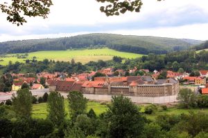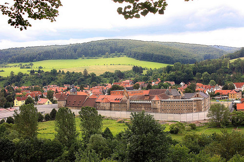
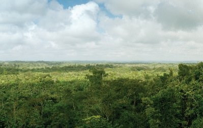
Walking through this ancient Central American jungle landscape might be a puzzling, yet surprisingly delightful experience for a first-time visitor. You don’t clearly see the well-defined, great stone pyramids, ball-courts, temples, and other monuments so often attributed to great ancient Maya centers. But you see a tropical terrain that is anything but flat. There is a jungle-shrouded mound here, another one over there. A well-planned walking path winds through what one could describe as the Maya version of the Garden of Eden. Like the very first 18th and 19th century explorers of the Maya world, you see what could be ancient structures still hidden beneath their canopy shroud. Some of them have been partially exposed, betraying what might lie beneath, leaving the rest to the imagination. You soon realize that this place is very different than any other encountered in the Maya world. Today, archaeologists call this place El Pilar, which means “watering basin”, named for the abundance of streams around it and below its escarpment.
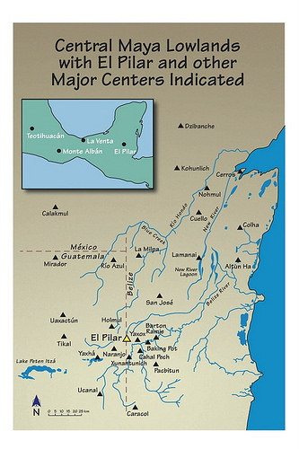
Divided along the imaginary line between western Belize and northeastern Guatemala, El Pilar is considered the largest site in the Belize River region, boasting over 25 known plazas and hundreds of other structures, covering an area of about 120 acres. Monumental construction at El Pilar began in the Middle Preclassic period, around 800 BCE, and at its height centuries later it supported more than 20,000 people. For three decades, archaeologist Anabel Ford has been exploring and studying this ancient Maya site. She is the Director of the Mesoamerican Research Center of the University of California, Santa Barbara. Unlike most archaeologists, however, she has taken a unique, highly selective conservation approach to investigating the site. With the exception of a fully exposed Maya house structure, most of the structures at El Pilar have remained completely conserved by design, still covered in their tropical shroud. She calls this ‘archaeology under the canopy’, where the natural environment enveloping the ancient monuments is maintained to protect the fragile structures from the elements. “Living biofilms attack the limestone where exposed, which rapidly deteriorates the vulnerable limestone facades,” she says. “It is tree cover that reduces exposure to sunshine and rain and maintains an even temperature that will preserve the monuments.”
__________________________________________
 Courtesy BRASS/El Pilar
________________________________________________________
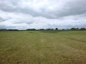
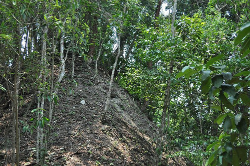
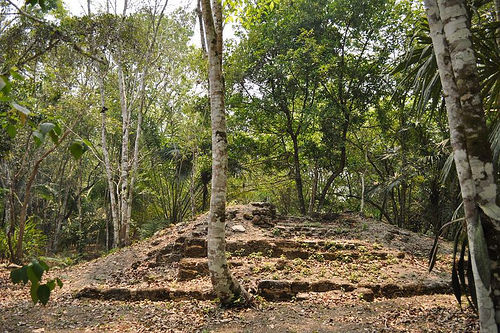
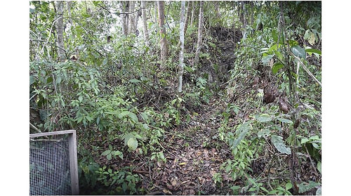
El Pilar lies below a thick jungle canopy. Courtesy BRASS/El Pilar
_____________________________________________
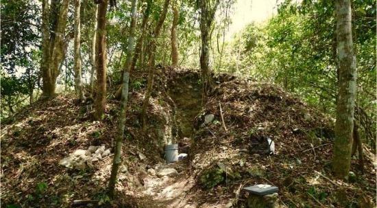
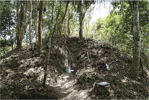
Above and below: Most of the El Pilar structures remain enshrouded in foliage, a natural strategy for conserving its remains. Courtesy BRASS/El Pilar Program
___________________________________________________________
____________________________________________________________
The Citadel
Despite the mask of it’s jungle cloak, Ford and other archaeologists know that El Pilar generally resembles the pattern exhibited by most ancient Maya centers. Years of ground research and surveys have revealed this.
But in 2013, Ford and her colleagues encountered something very different.
“We discovered a completely new component of the greater site that does not meet with any traditional expectations,” said Ford. “It shares nothing in common with Classic Maya centers: no clear open plaza, no cardinal structure orientation, and curiously no evident relationship to the major Classic period site of El Pilar, little more that 500 meters away.”
What Ford is describing is an unseen building, or associated complex of buildings, that was only detected by remote sensing technology—more specifically, a laser application known as LiDAR, or Light Detection and Ranging—in this instance an airborne remote sensing technique utilizing a helicopter employing laser technology to penetrate the thick vegetation and forest canopy that overlies and enshrouds objects and structures. It is a way of ‘seeing through’ the forest to reveal things otherwise invisible to the naked eye.
LiDAR helped to produce a remarkable map of El Pilar, revealing unexposed Maya architectural and other human-made features that, although still hidden from the naked eye, fit an often-seen pattern. This new set of structures, however, was something new. Dubbed the “Citadel” because of its location perched atop a 380-meter-long by 200-meter-wide ridge, it features concentric terracing and what appear to be defensive ramparts up the ridge. “Based on the LiDAR, we knew that the overall area of the Citadel was approximately 13 hectares from the hilltop to the limits of the lower ramparts” states Ford in her report to the Belize government. It is topped by several structures up to five meters high. Unlike the other complexes below and nearby, it seems by placement to have been isolated from the rest of greater El Pilar.
Never before had Ford seen anything like this in all her years of Maya research. What could it be?
_____________________________________________
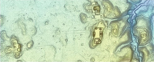
Above and below: LiDAR images showing the core area of El Pilar, with Citadel to its east (to the right in the picture). Courtesy BRASS/El Pilar
____________________________________________________________
Excavation
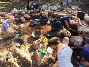
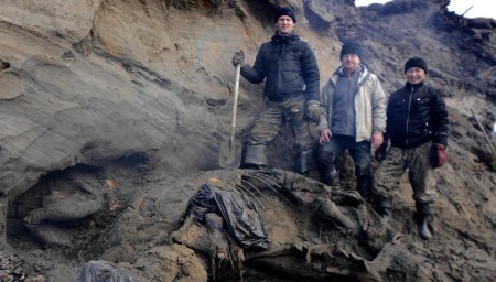
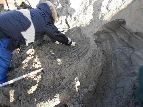
In a quest to find some answers, Ford returned to the site in 2015 with a small team, this time to do some ‘ground-truthing” and limited excavation to determine construction chronology and the age of the site. After arriving and beginning work, however, they found that they had to sift through extensive damage and debris left by looters. In addition, thick vines and underbrush had to be removed to examine and map the site. Despite this, the archaeologists began to develop a clearer picture of what they were uncovering.
“Covering almost 1 hectare, or about 2.5 acres, with 4-meter-high ramparts encircling a natural hill, the El Pilar ‘Citadel’ presents a remarkable image of construction ingenuity clearly with defense in mind,” said Ford. “While the lower two ramparts were created by the unusual strategy of quarrying into the limestone hill to create vertical faces that are impossible to scale, the upper terraces that make up the apex of the hill appear to be constructed with retaining walls and fill, a technique similar to most Maya monuments.”
“Our field investigations validated the architectural features of three in-line plazas from north to south along the hilltop,” writes Ford in her field report. “The northern plaza shows no evidence of superstructures, while the central (the highest) and southern ones supported ancient buildings, each with one temple and several other platforms.”* Stepped terraces were discovered to the north of the east corner of the North Plaza descending to the upper rampart. The Central Plaza featured the first five-meter tall temple with one platform to the south and one to the east with a small appendage. Immediately adjacent and to its south, the lower South Plaza featured another five-meter tall temple with an attached western platform. Two other small structures were located on the east side of the South Plaza.
The investigations confirmed some earlier LiDAR observations. Said Ford, “the archaeologists discovered that the placement of temples and platforms was not in the expected form that should be aligned in the cardinal directions at the edges of a plaza. Instead, the main central temple, at the highest point of the hill, is squarely in the middle of the plaza and oriented to the east.”
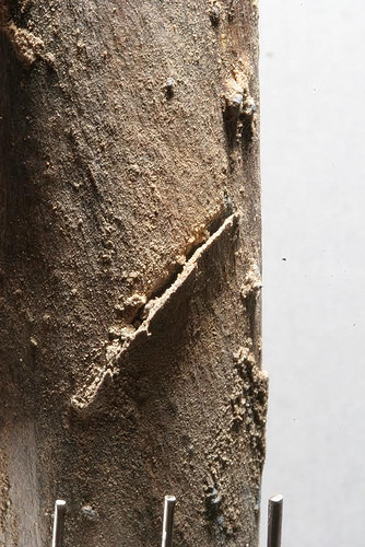
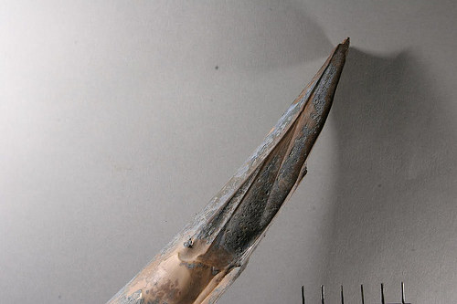
The team painstakingly cleared away the debris of looter’s trenches excavated decades ago into the core of the two temples. At the Central Plaza temple, the highest, archaeologists exposed a massive looter’s trench and shaft that demolished the center to a depth of more than 6 meters and exposed the details of some 10 construction episodes. Plaster floors, walls, stairs, rooms, and charcoal layers make up the sequence the archaeologists are piecing together from the devastation wrought by the looters. A second looter’s trench was discovered in the other temple, located within a southern plaza. Here, “the looter’s excavation destroyed the top of the temple and pried out beautifully dressed stone using picks on elegantly prepared stucco with painted black lines, showing cavalier disregard for the complexity of the ancient architecture,” said Ford. “Walls, doorways, additions, as well as a major plaster floor more than 25 cm think were so thoroughly damaged it is difficult to understand the architectural relationships.”
____________________________________________
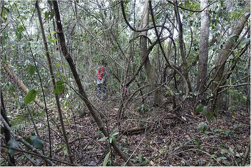
Thick vines and underbrush at the Citadel site had to be removed, leaving trees for shade, before further work and mapping could take place. Courtesy BRASS/El Pilar
___________________________________________________________
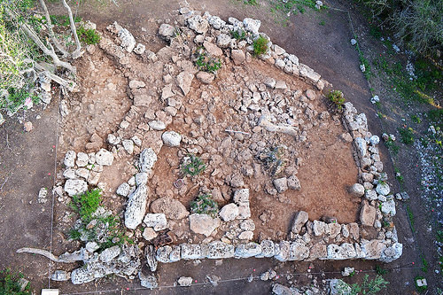
The center temple structure before removal of overgrowth and debris. Courtesy BRASS/El Pilar
_______________________________________________
Center temple after clearing. Courtesy BRASS/El Pilar
_______________________________________________

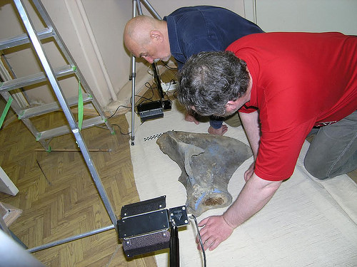
Mapping the Citadel. Dr. Anabel Ford (left) with Julia Longo, a key member of the special team. Courtesy BRASS/El Pilar
_______________________________________________
The Age of the Site
In the 2015 exploratory excavations, much of the work necessarily focused on the temple areas affected by the looters’ trenches, which meant recovering ceramic material and other artifacts discarded by the looters into the backfill of their excavations. Although stratigraphic context could not obviously play a role in this, Ford and colleagues found that most of the recovered material, which represented vessels of bowls, jars and plates, were “consistent with the Preclassic (1000 BC to 250 AD)”. “Slipped vessels were waxy and presented durable surfaces characteristic of the Preclassic,” she reported. “Curiously, there were a few pieces that might be considered Middle Preclassic.”*
Preliminary analysis thus indicates that the Citadel is a Preclassic, or Late Preclassic, construction. But more significant than this is what the finds suggest about the relationship of the Citadel to the rest of the El Pilar center. “More significant,” reports Ford, “is that there was absolutely nothing to represent any of the later Classic (AD 250 – 950) periods. The El Pilar Citadel is firmly placed in the Late Preclassic and suggests a time frame around 250 BC would be probable, the same time the main monuments of El Pilar were expanding. Yet at the Citadel the constructions were left by c. 250 AD.”*
In other words, by Classic period times, when El Pilar was at its height, the Citadel may have been a relic of the past. Either the site was abandoned and unused as obsolete and unimportant since Preclassic times or it may have been left, for perhaps sacred or other reasons, intentionally ‘undefiled’ by later modification or construction.
In any case, clearly it was regarded as something significant at some point in ancient Maya history. The enormous work that had to be expended for the construction of its massive ramparts and associated concentric terraces seem to testify to a defensive work of monumental proportions. Reports Ford: “The rampart rings are the most distinguishing feature of the El Pilar Citadel, giving it an appearance of a bivallate European hill fort. The upper rampart, 14 meters below the Central Plaza at 224 meters, encloses a 20,000 square meter area and the lower, 38 meters below the Central Plaza at 200 meters, encloses approximately a 68,000 square meter area……..these ramparts present 3-4 meter high vertical obstacles with no obvious entry points.”* Ford estimates that their construction would have required the removal of approximately 12,400 cubic meters of earth and stone.
No small feat, that.
___________________________________________
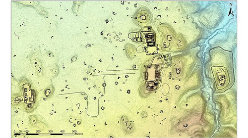
LiDAR image showing more clearly delineated core area of El Pilar, and the Citadel to the far right, east of the core area. Courtesy BRASS/El Pilar
_____________________________________________________________
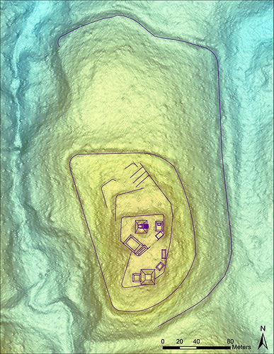
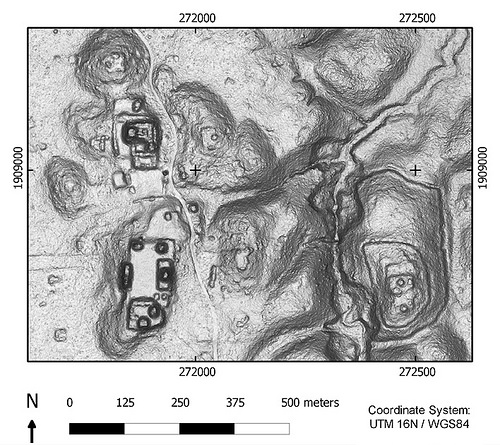
LiDAR image showing the Citadel with renderings of currently-detected structures and their relative dimensions and locations at the top of the ridge, including the two lower ramparts. Courtesy BRASS/El Pilar
______________________________________________________________
The Enduring Mystery
Archaeologists are now only beginning to scratch the surface to understand the nature, function, and dating of the site—and its enigmatic relationship (if any) to the Classic period El Pilar core site nearby. Answers to these key questions may help place the Citadel, and El Pilar generally, within the context of ancient Maya civilization and society in general.
The most recent excavations, including the analysis of recovered ceramics and profile maps developed from the initial Citadel ground investigation, however, have provided a few opening round clues and raised new questions. Whatever it is, the hilltop structures were constructed in Late Preclassic times, when the adjacent main site of El Pilar below it to the west was first expanding its monumental structures. Thus far, nothing has been recovered to date the ‘defensive’ ramparts and terracing, so it is not entirely improbable that they could have been built at a later time, such as the Classic period, to protect the site for some unknown reason. So were they constructed to protect the hilltop establishment while it was in use, or were they constructed to protect it as a sacred relic of the past? Finally, no Late Classic material was recovered from the looters’ trenches of the Citadel, the time period when El Pilar witnessed the bulk of its construction—this suggests the Citadel “was not integrated into the Late Classic civic monuments of El Pilar”.*
Ford is the first to suggest that much more work needs to be done before the mysteries of the Citadel can be solved. But a promising start has opened the way for more intensive and refined research.
“What was its significance? How was it used? Why was it isolated?” asks Ford. “There is no doubt we will have a better sense of the place after the investigations.”
__________________________________________________________
* Anabel Ford, Unexpected Discovery with LiDAR: Uncovering the Citadel at El Pilar in the Context of the Maya Forest GIS, University of California, Santa Barbara, December 2015
__________________________________________________________