Posted on August 16, 2018 by Bruce Bachand -
Bruce Bachand is a Research Affiliate with the New World Archaeological Foundation of Brigham Young University and Director of the Chiapa de Corzo Archaeological Project since 2008. A recent Fulbright fellow, Bruce has received grants from the National Science Foundation and the National Geographic Society for his research on early Mesoamerican societies. He holds degrees in Anthropology from the University of Massachusetts Dartmouth (B.A. 1993), Brigham Young University (M.A. 1997), and the University of Arizona (Ph.D. 2006). Prior to his Chiapas investigations, Bruce supervised fieldwork in the Petén rainforest of Guatemala at the Maya sites of Nakbe, Aguateca, and Punta de Chimino. He describes himself as “an anthropologist who happens to dig in the dirt” and a student of cultural history. His scholarly interests range widely from anthropological theory to pottery analysis and Bayesian radiocarbon dating–subjects that articulate well in archaeological storytelling. He has authored a variety of essays and articles, but his most prized effort remains a dissertation chapter summarizing ten years of research on Preclassic Lowland Maya civilization. He is currently working on an essay that clarifies the material practices of Zoque culture through time. Bruce’s fascination with the symbolic dimensions of human life, both modern and ancient, has led him to spend prolonged periods of time in Japan, Europe, the American West, Mexico, and Central America. He vividly recalls starting his archaeological endeavors by promptly impaling his finger with a trowel while digging a Jōmon pit house alongside three well-trained and obliging elderly Japanese women. His most wretched archaeological memory is the excavation of a prehistoric lithic scatter underneath a partly decomposed, stinking sheep carcass ridden with rat feces outside a southern Utah rock shelter. As an anthropologist he has been influenced greatest by the writings of Marshall Sahlins, Michael Jackson, and Antonio Gramsci. In archaeology, he finds a certain affinity with the writings of Richard Bradley, Ian Hodder, and Julian Thomas. In Mesoamerican archaeology, Gordon Willey, Gareth Lowe, Michael and William Coe, and Kent Flannery have left indelible impressions. Raised in southeastern Massachusetts, he is married with two children and resides in the Salt Lake City area.
Editor’s Note: The following article is republished from the earlier article issued in the June 3, 2011 issue of Popular Archaeology.
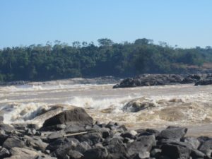
The world’s ancient civilizations were resourceful blends of language, ethnicity and popular culture. Entangled in the middle of Mesoamerican genesis was a precocious society whose attributes are now coming into sharper relief thanks in part to investigations financed by Brigham Young University’s New World Archaeological Foundation and the National Geographic Society in collaboration with investigators from Mexico’s Instituto Nacional de Antropología e Historia INAH and National Autonomous University (UNAM). The ancient Zoque of western Chiapas appear to have shaped beliefs and traditions that became commonplace among their Mesoamerican neighbors. One of their capitals, Chiapa de Corzo, began as a modest village three millennia ago on a plateau overlooking the torrid banks of the majestic Grijalva River. Between 800 and 700 BC, this village evolved into one of the earliest and largest linearly planned towns in Mesoamerica. Recent archaeological discoveries in Chiapa de Corzo’s tallest, most central pyramid, Mound 11, provide insight into the site’s rise, its long distance relationships, and the origins of so-called “E Group” astronomical buildings.
_______________________________
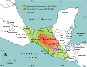
Map of the Zoque region. Illustration by Bruce R. Bachand
________________________________
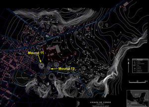
Map of Chiapa de Corzo showing location of Mounds 11 and 12 and encroachment of modern development. Composite of Martínez 1960, González 1985, and Aguilar 2008; digitized by Roberto Carlos Hoover, courtesy of the New World Archaeological Foundation.
________________________________
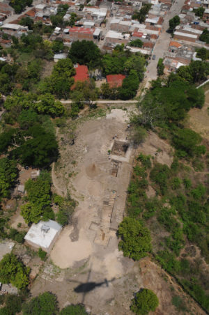
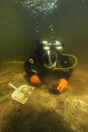
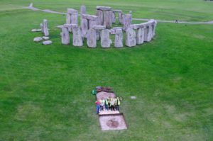
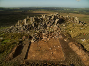
Mound 11 at the height of excavation in April of 2010. Photograph by Oscar López, courtesy of the National Geographic Society.
________________________________
The Tomb
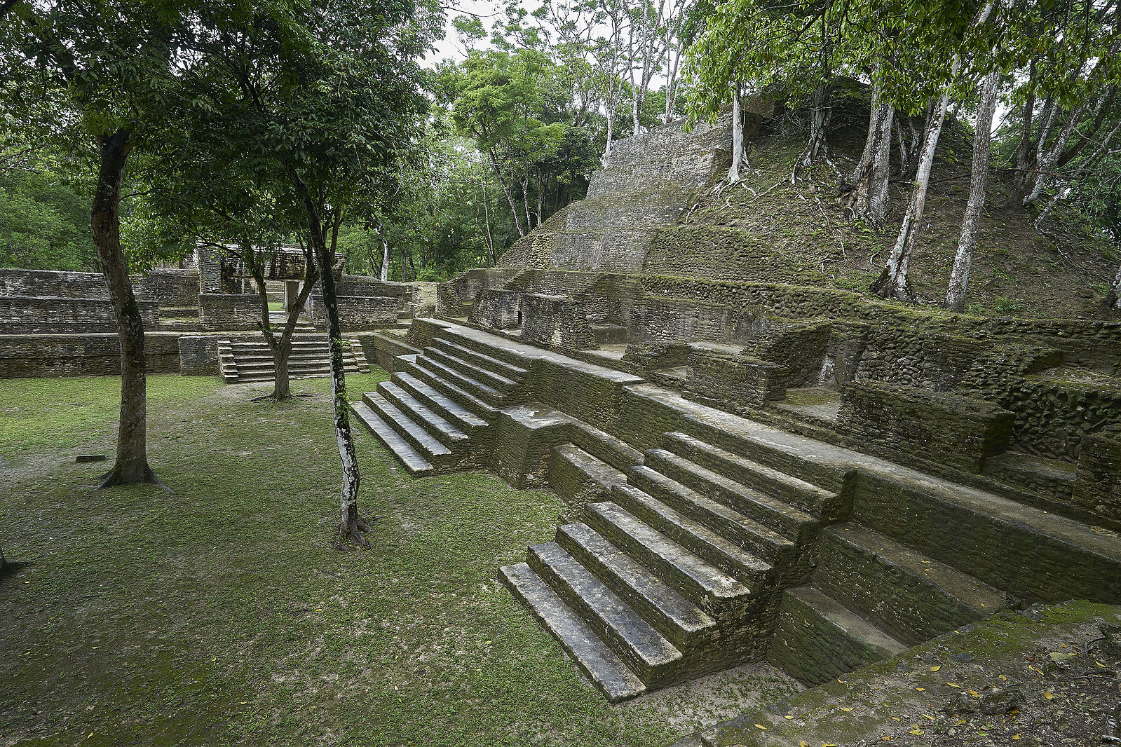
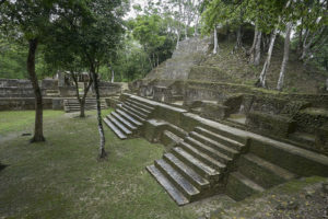
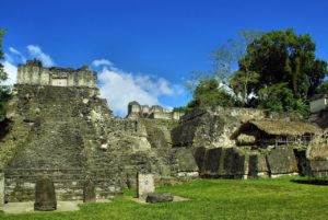
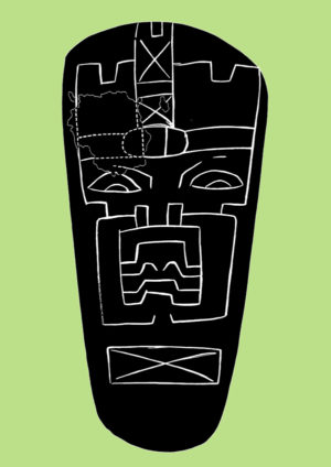
An elaborate pole-and-plank roofed chamber built into the top of an earlier pyramid discovered deep within Mound 11 is a modern day archaeological marvel (see Bachand and Lowe 2011). It was created six centuries before the oldest known pyramidal tombs in Mesoamerica, those recorded at the familiar Maya sites of Tikal and Kaminaljuyu. The skeletons of the principal occupants, a middle-aged male and female, were adorned from head to toe with beaded ornaments from which nearly 4,000 pieces of jade, pearl shell, iron pyrite, hematite, and amber have been tallied. Their front teeth sparkled with circular inlays of iron pyrite and mother-of-pearl. Seventeen ceramic vessels, two human sacrifices, nine ceremonial axes, two pyrite plaques, and mosaic eye pieces from several perishable masks rounded out the mortuary assemblage. The names of the deceased are unknown; the earliest legible hieroglyphs are a millennium later in date. The main occupants were likely a conjugal pair that governed Chiapa de Corzo and the surrounding countryside.
___________________________________
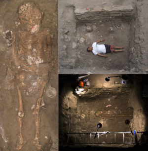
The skeleton of Tomb 1’s main occupant: a regally adorned middle-aged male. His skull was crushed like a pancake when the tomb collapsed anciently. White residues on his lower torso and pelvis are probable vestiges of bark cloth attire. Remnants of a shell-decorated loin cloth descend from the pubic area. Photographs by Bruce R. Bachand, courtesy of the National Geographic Society.
___________________________________
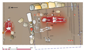
Plan of Tomb 1 illustrating the location of the occupants and offerings. Cinnabar coated the bodies of the two primary figures. One of these, an adult female, was placed on a landing connected to the crypt by a stone paved ledge, a vermillion-painted flag set in the middle. Blue dashed line marks the inferred edge of the crypt Drawing by Lynneth S. Lowe and Roberto Carlos Hoover.
___________________________________

Ceramic vessels from the tomb. Photograph by Bruce R. Bachand, courtesy of the National Geographic Society.
___________________________________
The tomb exhibits Olmec rather than Maya affinities. Jade beads fashioned into duck heads, clamshells, pumpkin-shaped gourds, and bamboo shoots are similar to artifacts excavated seventy years ago at the mammoth Gulf Olmec site of La Venta. Green and gray obsidian disks—eye pieces for wooden or textile masks now long decayed—are also similar to pairs of disks found in a tomb and offering at La Venta. Most of the ceramic vessels in the tomb bear no resemblance to Maya pottery of similar age. Their closest parallels are found in western Chiapas, the Gulf Coast, and the Highlands of Central Mexico. It is not surprising to see long distance ties represented in a prominent tomb of this era; the period was marked by social exchanges between powerful leaders in culturally distinct regions. When objects like these are discovered it is easy to overlook or downplay what is unique or distinct about the context. The absence of large jade earspools on the heads of the deceased (a signature Olmec trait), and the placement of clamshells over their mouths (a practice that continued for centuries in Chiapas), appear to be expressions of local identity and belief. Strontium isotope ratios obtained from human bone will hopefully tell us which region these individuals resided in as youths, providing yet another angle on the many-sided matter of their social identities.
________________________________
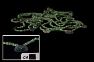
Nearly 1,000 pieces of jade comprise this dazzling necklace worn by the principal male occupant. Seventeen clamshell-shaped jade pendants were spaced throughout the arrangement. Photographs by Bruce R. Bachand, courtesy of the National Geographic Society.
________________________________
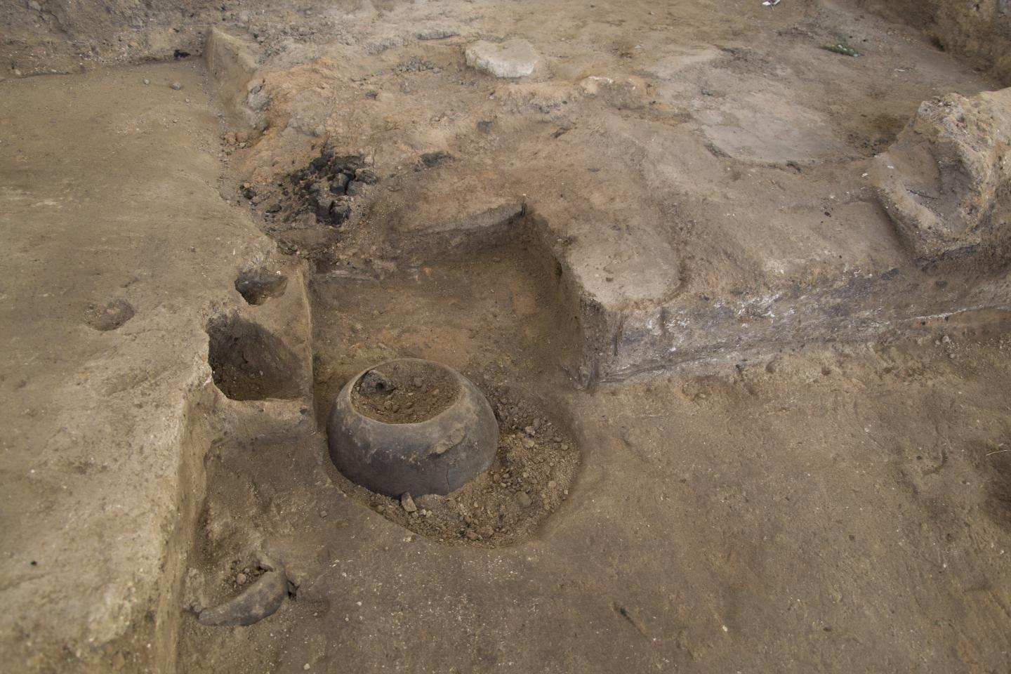
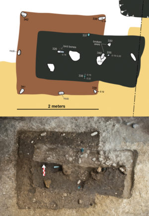
The tomb is ascribed to the same period as a series of extraordinary ritual deposits placed at the foot of the pyramid in what must have been a single dry season. Two, massive bedrock pits containing layered linear arrangements of ritual stone axes, an elaborate sacrificial burial, and a serpentine axe with a crudely engraved image of an Olmec deity were inserted below the plaza in alignment with the pyramid’s centerline and the four cardinal directions. A third offering, a shallow T-shaped pit containing a cross pattern of four greenstone axes, was created at the pyramid’s toe. These offerings were promptly sealed beneath a lime paved surface following a ritual feast, the latter evidenced by a series of drinking vessels and an empty, keg-sized pot strewn across the top of the deposits. The 340 or so axes recovered in these offerings ranged from expertly ground and polished specimens to minimally modified rocks and unaltered stones that naturally exhibited the form of an axe. This and the haphazard arrangement of some axes implied that people with little or no ritual knowledge or lapidary skill partook in the event.
___________________________________
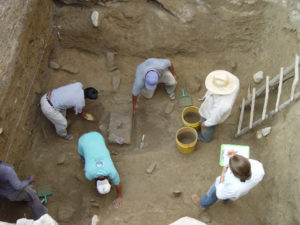
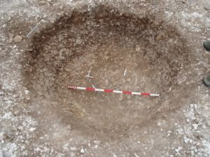
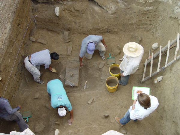
Excavation of Massive Offering 1 in March of 2008. This was the first of two bedrock axe offering pits discovered at the base of Mound 11. Photograph by Joel Janetski, courtesy of the New World Archaeological Foundation.
___________________________________
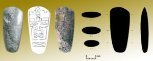
Serpentine axe with the incised design of an Olmec supernatural. This object and a flat green celt were planted in the ground with bit-ends up on the central axis of Massive Offering 1. The engraved image faced west toward the pyramid. Illustrations by Áyax Moreno, courtesy of the New World Archaeological Foundation.
___________________________________
Olmec design on the serpentine axe discovered in Massive Offering 1. Illustration by Áyax Moreno, courtesy of the New World Archaeological Foundation.
___________________________________
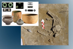
An adult male sacrificed in Massive Offering 1. Serpentine tube and bivalve shell were worn around the neck. Remaining objects were placed where the feet would have been. Photographs by Bruce R. Bachand and illustrations by Áyax Moreno, courtesy of the New World Archaeological Foundation.
___________________________________
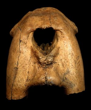
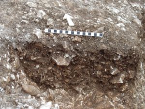
T-shaped offering pit located at the toe of the stepped clay pyramid housing Tomb 1. Its shape and axes represent a theme portrayed by San Lorenzo Monument 18. Photograph by Bruce R. Bachand, courtesy of the National Geographic Society.
___________________________________
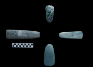
Greenstone axes and celts from the T-shaped offering pit. Objects are arranged as found: flat, squarish celts on the E-W centerline and teardrop shaped axes on the N-S centerline. Photograph by Bruce R. Bachand, courtesy of the National Geographic Society.
___________________________________
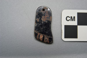
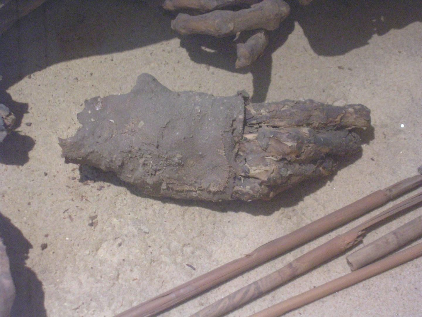
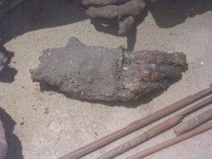
Hematite pendant in the shape of a foot from Massive Offering 2. Photograph by Bruce R. Bachand, courtesy of the National Geographic Society.
___________________________________
A Center of Community Ritual
The collective nature of these magnificent ritual designs and the pyramid’s central location in the civic layout indicate that this event signaled something remarkable—perhaps the start of a new type of community. The elaborate offerings were promptly concealed, never to be gazed upon again, but future residents continued to mark the hallowed spot for centuries. From this point on, Mound 11 and its counterpart Mound 12 became the symbolic nexus of the site, the place where people celebrated their heritage and performed community rituals to chart their future actions. This is duly indicated by the continuous refurbishment of monumental buildings and subsequent installment of deceased nobles and ritual offerings.
The size, shape and arrangement of Mounds 11 and 12 resemble solar or astronomical precincts commonly referred to as “E-Groups” in later Maya sites. This iconic monumental pattern appeared at Chiapa de Corzo and many other Chiapas sites between 900 and 800 BC, one or two centuries before it took hold in the Maya region. Our findings at Mound 11 demonstrate rather forcefully that early E-Groups were associated with community ritual, lighting, corn, the cardinal directions, human sacrifice, and rulership (the axes being fairly well attested representations of lighting and corn). It is additionally clear that the above associations were tethered to Olmec conceptions of the supernatural. Chiapa de Corzo’s E-Group was one of the largest and earliest constructed in the Central Depression of Chiapas. It was planned with a keen awareness of the natural landscape. Mound 11 and its massive axe deposits were positioned about 1,500 m (one mile) equidistant from two solitary hills on the site’s northern and southern perimeters; the site’s north-south axis paralleled the sight line between these hills (observations pointed out by project artist Áyax Moreno and verified topographically by Dr. Timothy Sullivan).
The Olmec Connection
At 70 ha, Chiapa de Corzo was one of the largest settlements between the Olmec and Maya regions from 900 BC to AD 400. The last twenty years of archaeological and linguistic research have demonstrated that Chiapa de Corzo and west-central Chiapas were home to the Zoque, descendents of the Mixe-zoque speaking Olmec who inhabited the Gulf and Pacific Coasts of southern Mexico during the Early Formative period (1500-1000 BC). Recognizing ancient Chiapa de Corzans as Zoque has ramifications for understanding the ethnic composition of Middle Formative (1000-400 BC) Gulf Olmec centers such as La Venta. The two sites share the same general site plan and construction methods, but do not possess the same domestic pottery or quantity of braziers and roller seals. Chiapa de Corzo lacks large stone monuments in the form of colossal heads, altars, and stelae. It does, however, display the peculiar Gulf Olmec fondness for arranging public spaces around swamps and ponds.
The similarities are not casual. The two centers shared a common Early Formative Mixe-zoque heritage. So were La Venta’s builders also Zoque? This is the ten million dollar question. When the Middle Formative period started two other language groups, Mixe and Popoluca, also split from Mixe-zoque and Mayan speakers began to drift westward into Tabasco. This means La Venta was likely a linguistic and cultural melting pot. Its size certainly could accommodate a diverse population. Its 200 ha monumental core and surrounding settlement dwarfed anything in Mesoamerica at the time. One culture may have taken the lead in generating La Venta’s public creations. But if the city was multicultural, different cultures could have contributed different elements to its design over time. In short, we do not know whether the elements shared with Chiapas sites appeared simultaneously or in staggered succession at La Venta, Laguna de los Cerros, Tres Zapotes and other lowland sites. It would be rash to envision La Venta or Chiapa de Corzo as immiscible entities; La Venta was surely the more cosmopolitan of the two. But if one culture can be pegged for playing a dominant role in La Venta’s florescence, it would have to be the Zoque, considering the many ties seen in architecture, site planning, and sumptuary items across the two regions.
__________________________________

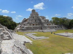
The Gulf Olmec site of La Venta in Tabasco, Mexico. In the background is the ‘Great Pyramid’ or Mound C-1. At 34 m (110 ft.), it was the tallest building in Mesoamerica during the Middle Formative period. Never probed, its interior probably contains construction episodes of varying ages. Its outermost phase has been radiocarbon dated to circa 400 BC. Photograph by Bruce R. Bachand.
__________________________________
The tomb and axe offerings described in this article illustrate that the Chiapas Zoque were already quite advanced before La Venta became a major city. Could they have stimulated a renaissance in the Gulf Coast zone? Unfortunately, we still lack a basic picture of what the great Gulf Olmec centers looked like around 900 or 800 BC. In the meantime, the latest findings from Chiapa de Corzo provide stupendous evidence of the attire, burial customs, and symbolic creations of Middle Formative Mesoamerican paramounts – evidence that beforehand was largely garnered via the study of artistic imagery. On a broader scale, these latest discoveries temper our notions of Gulf Olmec hegemony or of an early Mesoamerican landscape inhabited by equals, and pull us into the nitty gritty aspects of Middle Formative history where the unpredictable forces of human agency, events, and culture made their mark. As we grapple with new information collected from sites like Chiapa de Corzo, we venture onto new scientific terrain, and do so with our eyes open to what the past will afford us.