
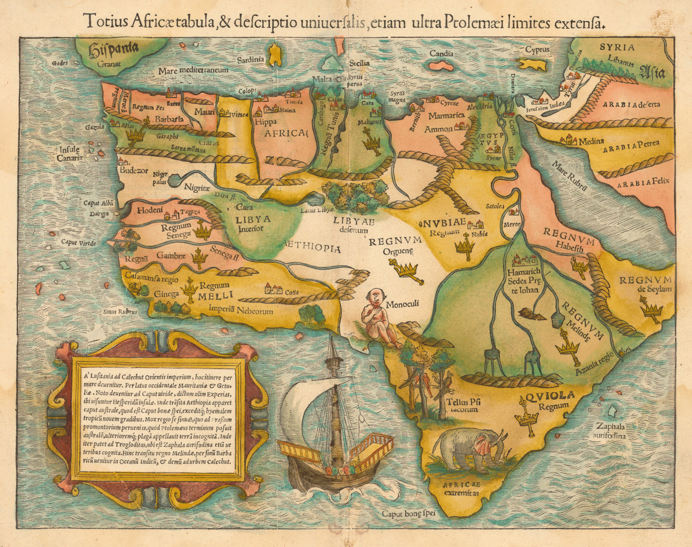
In the first half of the 1400’s, a scholar-monk named Fra Mauro, from the monastery of San Michele di Murano in Venice, was commissioned to create a new world map based upon the most recent research and travel accounts from explorers across the Mediterranean region. He began compiling notes, collecting maps, and over the next decade, he pored over travel accounts, comparing written interviews of travelers, ambassadors, and seafarers. Refugee-scholars from Constantinople, sages from India or regions farther east, and ambassadors and priests from Ethiopia supplied snippets of data. Rarely, knowledge tumbled in tomes, but more often it was pieced together from fragments lost to the west for centuries. Gradually, for the first time in Europe, remote, empty spaces on his map filled in with mysterious, unknown cities or mountains tied to legends — even the source of the Blue Nile. Thankfully, for Abassia Ethyopia, this region was sketched by the very hands of intrepid sojourners in these furthest reaches of our globe.
___________________________
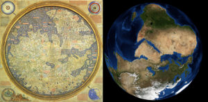
Fig. 1 – The Fra Mauro Map – 1450, compared to a NASA photo of the same view. Note: the map is southern oriented.
___________________________
Old maps represent our three-dimensional world within a two-dimensional, mental construct. Each paints a time-bound icon for visualizing a given worldview. In essence, maps embody the world made in our image. Fra Mauro’s mid-15th century masterpiece of medieval cartography now provides scholars a rare lens into a radically variant geographical mindscape during one of the most critical transitions in world history (Cattaneo, pp.123).
The resulting circular map, nearly two meters across, appears now to have served not simply as an aid in expediting navigation or exploration. Rather, it seems to have been designed specifically to lay out the foundations for a new world order. By drafting geographical features, regional and city names, and navigable trade routes across his mappa mundi, Fra Mauro identifies possible alliances alongside real and potential threats. Anything Christian, even the thinnest web of connectivity, is emphasized.
Mountains feature prominently throughout. Passes or rivers clearly bisect habitable landscapes, demarcating regions and polities. Every city stands fortified, bounded by copious notes on regions, rulers, rivers, and where gold, spices, pearls, and fresh water can be found. Ships, identifiable with the dominant traders, ply their respective seas. Welcome to the world as it was perceived in 1450.
To set the stage for this intriguing story, and so many new discoveries in Ethiopia, we must consider that Ethiopian emissaries and monks in the mid-1400’s related geographical information of their own Ethiopic regions to a Venetian monk, who transcribed their data on a two-meter diameter parchment. Fortunately, along with local chronicles and hagiographies, itineraries of contemporary Europeans visiting these regions, and recorded by Alessandro Zorzi, provide substantial evidence of thriving communities. Our team focused upon this transmitted information, along with many newly translated manuscripts from these regions and periods. Working alongside local, state, and federal partners, as Fra Mauro stated, we too have attempted to carefully “verify the text by practical experience” as we trek landscapes described nearly six centuries prior. Other travelers, including one Pietro Rombulo, and the artist, Nicolo Brancaleone, left lasting impacts upon religious Ethiopic art. In one remote island monastery I recently discovered a painting from this period, evidently from a European hand, which needs further research and restoration. Such hidden treasures and finds, thankfully, are being recognized by local and international scholars.
___________________________
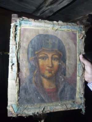
Fig. 2 – Early Renaissance European painting recently discovered in Lake Tana region of Amhara, Ethiopia
___________________________
The World Within a Gilded Frame
Regarding these regions, Fra Mauro states in inscription number *98: “Because to some it will appear as a novelty that I should speak of these southern parts, which were almost unknown to the Ancients, I will reply that this entire drawing, from Sayto (Assiut, Egypt) upwards, I have had from those who were born there. These people were clerics who, with their own hands, drew for me these provinces and cities and rivers and mountains with their names; all these things I have not been able to put in due order for lack of space” (Falchetta, pps. 210-203).
___________________________
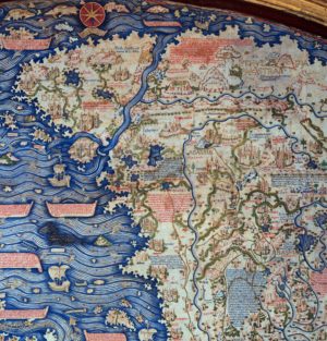
Fig . 3- Close up of the Fra Mauro Map indicating the Swahili Coast and Abyssinia – Ethiopia. South is top.
___________________________
Nearly six centuries on, having survived multiple European wars, these medieval icons of mountains and rivers, along with descriptions of rulers and names of now long-lost cities, make their way, as a digital copy, to an African-born archaeologist working in Ethiopia, hoping to discover the buried capitals many believed never even existed. My first task was to employ an Afrocentric, indigenous frame of reference for our ongoing research.
Within many African cultures, proximity to neighbors is measured by a scale of time, not distances of length. Karibu means “Welcome,” in Swahili, but it can also mean “close” or “near.” When trekking in East Africa, therefore, upon inquiring the distance to the next village, the answer depends on the closeness of the village relationally, not proximally. I have walked over 30 kms, passing through “far away” villages, to get to the “close one.” On the Fra Mauro map, African distances are similarly inscribed. Cities along the highland ridge, known best by his informants, are situated neatly along the trade routes used even today. Specific characteristics of each city indicate familiarity, or karibu to these monks. Barara and Sadai particularly, are shown with multiple cultural elements and architectural features. Unfamiliar Islamic regions along the coasts, for the most part, are depicted in uniform monotony.
Our investigations in the field confirm the uncanny accuracy and completeness of Fra Mauro’s informants. It also indicates a far more complex and rich societal narrative of Ethiopia than is commonly portrayed. Honest research and scholarship points to the broader natures of cosmopolitan and blended cultural, linguistic, and religious communities of the past. Throughout Ethiopia, our recently identified sites, with divergent cultural material, beautifully illustrate this continuity of settlements from prehistory to an unknown pre-Christian civilization contemporary with the Aksumite Empire through to the pre-medieval and medieval periods, all the way into the conflicts of the last two centuries.
What we have discovered, with evidence on the ground, is that the monotone story of Ethiopian history being told only through the lens of monumental architecture or singular empires, dynasties, or rulers, does a great disservice to the broader, deeper narrative of modern Ethiopia’s true heritages, cultures, languages, and religious identities. Selective remembrance or backward-looking and biased discourse about who owns what based upon a particular event or the few written accounts by ecclesiastics or outsiders, should be replaced with actual scholarship. The time is far past due for professionals to be able to do their jobs.
Cracking the Fra Mauro Code
By the end of the 17th century, memory of the devastating conflicts between the Islamic forces of Imam Ahmad, known as Ahmad Gran or the left-handed, and the variably named Christian kingdom of Shoa, Xoa, or Sewa, had cooled to an uneasy, smoldering detente. As with many regions across Africa, these ruinous wars prompted subsequent migrations of populations, followed by the influx of shifting cultures and languages across Ethiopia’s landscapes (Newman, pp. 99). Such fluctuations displaced previously associated oral traditions and much place-memory. Place names, however, recorded on old maps and in various chronicles and hagiographies, as well as Crawford’s Ethiopian Itineraries (1958), amply illustrate that prior to these religious wars, populations from a variety of cultures lived in mixed, settled communities throughout Ethiopia, much as they do today. The Fra Mauro map states that certain regions, mountains, even cities, had variant names depending upon the people-groups living nearby.
As a result of these multicultural migrations, new settlement patterns and agricultural practices shifted the way land was utilized. What previously had constituted defensibility shifted. The political landscapes and settlement densities moved to higher ground. Small land holdings replaced large urban centers. Across Ethiopia’s landscapes, centuries of agro-pastoralism have literally plowed the ruins of once-thriving metropolises into the ground.
Accounts of the destruction of Barara and other cities and churches accurately depict that demolition was total. Even grindstones were smashed to ensure populations had nothing to return to. During the religious wars, most associated religious structures, on both sides, along with their treasures of relics and manuscripts, perished, usually via fire. This loss of contexts with which to even begin to identify lost cities was exacerbated by a paucity of scholarship related to these eras. Additionally, the perception, given Addis Ababa’s modern status, seems to have tacitly colored the idea that it must have had medieval importance as well. But it is hard to hide cultural materials, such as ceramics, stone tools, occupational soils, etc. Such indices a true archaeologist recognizes immediately.
As detailed in my previous article, we felt certain we had cracked the code of the Fra Mauro map related to Abassia Ethyopia. It appeared possible to now trek Ethiopia’s variable landscapes, and through the centuries, identify specific physical features drawn by Ethiopian monks and emissaries, “with their own hands”. To prove we no longer were living in terra incognita, we had to put our hypotheses to the ultimate test. We needed to discover a city absent from all later maps; a city lost since the religious wars of 1528-1543, to all record and memory. But major obstacles remained, not the least involving geopolitical ramifications wrought by decades of war’s desolation. Like words borrowed from an archaic vocabulary, we had to translate mountains and rivers not simply as physical geography, but more importantly, through a medieval African mind’s eye. It was these corresponding geographies, so accurately drawn, which proved our first key to ultimately unlocking the location of Africa’s longest-lost city on the Fra Mauro map, Barara.
__________________________
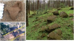
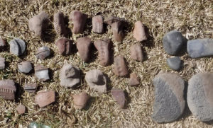
Fig. 4 – Sadai – Ceramics, walls, architectural features and alignments on the slopes of the Suba Forest – Mt. Wechecha.
__________________________
A Tale of Two Lost Cities: Tegulet and Barara
As we continued our desk-based analysis of maps and written records, the two lost cities — Tegulet (1315?), the first Restored Solomonic capital, and Barara (1385?), the Holy Grail of lost medieval African cities — asserted their presence. All place-memory of these medieval capitals had vanished. Local chronicles mentioned the importance and general region of Tegulet, but without specifics. Barara, though mentioned throughout Europe’s medieval period as the capital of Abyssinia, remained a mystery. Strikingly, local chronicles never mention that name. It is possible this is another example of cities retaining different names based upon populations.
Utilizing the remote sensing methodology we had devised, we narrowed our search for Tegulet to the drainage basin of the Jemma River, north of Debra Berhan. Within less than a half hour, scanning images on Google Earth, we identified three possible candidates for occupational-site, all with probable architectural features. Hopeful, we ventured forth on an excursion to discover what we believed to be one of the most important sites to enable us to rewrite Ethiopia’s history.
The candidate for Tegulet was exceptional. Foundations of monumental architecture proved a substantial settlement had, at one time, dominated the landscapes, and thus the trade routes. One surprise was a purpose-built road, 12 kms along the ridge, with ruts from wheeled vehicles, dated to a time where no record of wheeled vehicles exists. Cultural material abounded, including quantities of quality ceramics, raw iron and slag, and semi-precious stones traditionally used for vestments, ceremonial crosses, or to adorn valuable manuscripts. Adding to that the many newly identified Washa or cave churches, and it all adds up to a substantial archaeological find in the exact location we could have predicted, using our model and ancient maps.
____________________________
Fig. 5 – Architecture and features signifying monumental construction.
____________________________
Barara on the Horizon
Discovery wasn’t going to be easy, but we decided first to investigate the southern ridges along the Germama and Kessem river drainage basins, and areas south of Sendafa, along the still visible ancient trade routes to regions north. Even today, this highland ridge route serves as a gateway from the plains and valleys in the south and east into the highlands of Gojam, Shewa, Gondor, and Welo.
It is difficult to describe the anticipation of being the first to knowingly tread the ruins of a legendary city lost for nearly six hundred years. There is in equal measure a giddiness mingled with a sobriety of knowing, as Burton reported in his book, First Footsteps in East Africa, and among others, the Chronicles of the Kings, how Barara, and multiple other sites, were destroyed by fire and looted over many days. Given the multiple misleading political narratives and counterfactual “evidences” swirling around Addis Ababa being the same as Barara, however, our search for this lost city required far more sensitivity tied to careful, thorough science-based scholarship.
Barara had eluded explorers for centuries. I wish we could claim to have discovered Barara on our first outing, but it took us nearly another year of denials of access or papers, or, even at one point, being run off at gun-point, before finding our ultimate prize. Here, I wish to recognize the late Richard Pankhurst and Hartwig Breternitz. Their excellent work sets the standard for proper, scholarly investigation of this, and other important sites. It is hoped our forthcoming published research will emulate the valiant effort of these two gentlemen-scholars.
___________________________
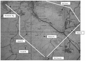
Fig. 6 – Image taken from Pankhurst and Breternitz.
http://www.persee.fr/doc/ethio_0066-2127_2009_num_24_1_1394
___________________________
On our first excursion, we entered the market town of Areda Weyra. An abandoned crossroads most days, this Saturday it bustled, employing every mode of transport or beast of burden: camel, donkey, mule, horse-drawn carriage, motorcycle, and of course, the heads or backs of the panoply of humankind. Like a drama playing out as it had from medieval times, commerce from three distinct regions joined, bartered, and returned with goods in tow. Throughout Africa, each beast of burden is suited to particular loads, climates, and environments. Camels thrive in the dry, lowlands and riverbeds at elevations below 1500 meters. They cannot even breed at higher elevations. Mules and horses are midland animals, mostly suited to the fertile plains and flatlands of the regions south of Addis Ababa and the well-watered grasslands below 2800 meters. Donkeys fit all elevations, but are the exclusive animal for higher elevations, steep ravines, rugged highland trails, and seemingly impossible passes.
Areda Weyra, at 2600 meters, served as a rare intersection for all three species, and by extension, represented well-defined regional cultures, languages, and religious identities. Even if the memory of Barara had long dissipated to dust, watching camels undulate home down a trail used for centuries, or a horse canter across open stretches, or observe overburdened donkeys clatter down a steep, rubble strewn path, there was a sort of mysterious kinesthetic memory at play.
This is what Barara had been; a nexus of cultures and commerce for centuries, and it provided us our first clue to keep us coming back for more. Inquiring of many aged priests, we were excitedly told this was an old place, destroyed by Ahmed Gran. This was a place, from before the religious wars, where emperors once lived, but no one could tell us exactly where. One jovial saint swept his hand across the horizon. “This is a blessed land, very rich, very good.” He smiled, and with a wink stated, “It is our Holy Land.”
With hopes high, we moved further along the south and west ridges, discovering many significant sites, but only legends or hints of names like Juggal or walls. Yet none recalled even a semblance to the name, Barara. Resolute, over the last year, we continued our searches. What we discovered were substantial, previously unknown sites belonging to entirely unknown civilizations, contemporary with the end of the Aksumite empire (6th-7th Cent. CE) and into the early medieval periods. Prehistoric, pre-Christian and Islamic settlements dot the landscape, and funerary markers, and even full cemeteries were recorded. The brilliant complexity disclosed in this newly revealed archaeological record illustrates the shifts and tides of peoples across these landscapes over millennia. But the common story they tell is of the continuity of the broader Ethiopian identity irrespective of modern, artificial standards based upon economics, national-tribal affinity, or religio-political terms.
__________________________
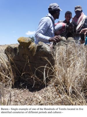
Fig. 7
__________________________
Prior to the Religious Wars, Christian and Islamic kingdoms mutually relied upon trade. Skirmishes and conflict were not uncommon, but annihilation of one side or the other was never the goal. Enter the dual outside influences of the Ottoman Empire and the expanding ambitions of Portugal. These shifted Ethiopia’s local narrative in radically, irreversible ways. In essence, the centuries-old tidal indigenous shifts and currents in hegemony and control of trade, took on global proportions, with a Jihadist mentality on one side, a Crusader fervency on the other. The resulting devastation brought about by this Mediterranean proxy war has yet to be fully studied or appreciated in the region’s historicity.
Referencing Guluma Gemeda’s well-considered article (https://kichuu.com/barara-is-not-addis-ababa/), we indeed have recorded substantial archaeological and cultural materials within a radius of 150 kms from Addis Ababa. These clearly illustrate a complex mosaic of multi-cultural contexts going back to prehistory. All these, and more, await proper research from professionally trained, field management experts.
___________________________
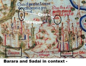
Fig. 8 – Comparing the iconography of the Islamic cities represented on the Fra Mauro map, the image of mosques is portrayed as a gold cupola and churches are represented by a cross. Sadai, being the ecclesiastical capital has only a church. Barara indicates both.
___________________________
Moving Mountains
Repeatedly I returned to the maps. New clues emerged. It was then I discovered previous searchers consistently had compounded a singular error. The blue, three-peaked mountain of the Fra Mauro map north of Barara is NOT Entoto. Tucked away in the series of valleys north of the Germama river, at the confluence of the Filambo river, lies a region, aptly named, Sost Amba, “Three Peaks”. This three peaked mountain range starts at Mt. Bereh, just northwest of Sendafa and continues up slope to the middle peak at the 2800 at the Fiche Genet pass to Debra Berhan. Profoundly, previous searches had taken everyone 20-30 kms too far west.
_________________________
Fig. 9 – Images of the Fra Mauro map superimposed upon the 1958 British topographical map
_________________________
We fully recognize the sensitivity of this discovery, which is why we have been painfully methodical in all our investigations. For peoples in the past, the topography surrounding Addis Ababa was inhospitable to networks of trade or easy passage. For this very reason, post-medieval rulers selected Entoto, not for commerce, but defense. At the behest of Queen Taitu, Menelik II selected the location for his capital (Addis Ababa, 1886), “New Flower” for the curative hot springs of Finfinne. Emperor Haile Selassie even contemplated moving the capital to other cities, including Bahir Dar and Addis Alem.
The historical narratives related to recent, modern Addis Ababa we gladly leave to historians to argue over. For our part, our team includes both local and international PhDs and Masters in the fields of archaeology, heritage management experts, and trained culture and tourism personnel. None of us is a tourist seeking treasures.
As a field-trained archaeologist and lead in this endeavor, the focus has been intensive desk-based analysis, field-walking, and scientific research. Having worked in excavations and surveys across the globe for 25 years, including Israel, Jordan, the US, Micronesia, and Aksum, there are few places left on earth with Ethiopia’s tremendous heritage and archaeological potential. As to Barara, our initial assessment indicates the site covers more than 2 square kms, with large quantities of period-specific cultural material along with wheel-made and imported pottery sherds throughout. True occupational soils over a meter thick, large architectural features including foundations for towers, a water system 80 m across, five cemeteries identified thus far from different periods and cultures, one containing hundreds of tombs, prove this is a substantial site fitting all the criteria for a city the size and importance of Barara. The traditional saying from the elders is that this was a city that “if you leave your home, you have difficulty returning.” In other words, the complexity and vastness made it a labyrinth.
Oral traditions and place names also fit exactly what we have sought. Bar, meaning gate and, as Mt. Yerer is locally called, Arra, would indicate this is the gate to the region of ‘Arra, or Bar-‘Arra. The local name of the site, translated “The Assembly of Multitudes”, retains the importance this region held in earlier time. Other interpretations of the meaning for Barara refer to “light” or “redemption.” Future research may tie the traditional Ethiopic name to the site we now identified with Barara.
The scattered sites of Entoto or the setting of Addis Ababa are often claimed, albeit falsely, to be synonymous with Barara. From a professional, archaeological standpoint, the site we have identified as the probable location of Barara is exactly what we would expect for a city with pre-medieval, medieval, and post-medieval occupational contexts. Still today, the villages atop the knoll and settlements south contain mixed Christian and Islamic communities. Additionally, it is exactly where Fra Mauro’s informants claimed it to be. The consistent misreading of a map, notwithstanding, Barara is clearly indicated as directly south of Sost Amba, east of the bend in the Akaki river, northwest of the confluence of the Dukem and Mojo rivers, and west of the fertile Tich plain. No true professional, seeing the broad cultural contexts on the ground, tied with the multiple site identifications we have made, would state otherwise. Thus, simply put, one cannot have the same city in three locations. It can only be where the facts on the ground and the map clearly indicate.
___________________________
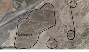
Fig. 10 – Architectural features along with hundreds of tombs over an area of nearly one square kilometer. Note: each hillock in the cemetery (bottom left) represents a tomb, many with inscriptions and designs. Scale bottom left – 100 meters
___________________________
The newly identified sites of Sadai, Tegulet, and Barara contain fantastic archaeological value and potential. The repeated mantra that Addis Ababa or the ruins on Entoto somehow secretly hide Africa’s largest lost medieval city, however, appears to have been fabricated upon frightfully wrong readings of an old map. What then of the current discourse on Entoto, or Finfinnee, or “the New Flower?” Sadly, pseudo-scholarship and misinformation has obscured true scholarship for so long, that this error has become part of, if not a central fixture to the dogmas of modern political discussions surrounding Barara. True scientific scholarship does not take sides. This research, therefore, should be utilized for promoting a broader dialog of Ethiopianness and unity rather than by proponents of a particular account for claiming proprietorship or precedence.
With the development within Addis Ababa over decades, no architecture or adequate quantities of cultural materials like ceramics and occupational soil contexts from multiple centuries have been unearthed. Would not someone, even with no training in archaeology, recognize it if it were present? Again, we, in no way, are advocating any political position or support for a given territorial dogma. We merely wish to state the evidence for the newly identified, true site of Barara far outweighs the faulty assumptions of those under-qualified to have made claims of an archaeological nature in the first place.
_________________________
Fig. 11 – Single-line 100 m field transect – Only diagnostics were collected and returned – Wheel-thrown and imported pottery, glass, and porcelain indicate outside influences and trade. Typical of an Imam Ahmed destruction, millstones and grinders have been shattered. Similar ceramic styles to early medieval vessels found at the Christian capital of Soba, Sudan (south of Khartoum) point to commerce and contacts.
_________________________
Building a Strong Foundation
Fully aware of the sensitivities related to this entire discourse, we have diligently worked directly with the Ministry and Bureau heads for Culture and Tourism for well over two years. We are in the process of accurately and professionally compiling and presenting our forthcoming publications and research for the identification of the true site of Barara. But we will not be pushed into making claims of ownership or domain. This is scholarly research, and as such, requires we continue to work with local, state, and federal partners to ensure this information is utilized for the benefit of all Ethiopians.
Going forward, the discussion should be about how we tie the broader, full archaeological record to the facts on the ground. This discovery is not about Entoto, or Addis Ababa, or Finfinnee, or Barara, or Tegulet. This is a story of the continuity of the weaving of an intricate and vibrant tapestry of Ethiopianness from the prehistory, through to today. Selectively pulling out threads somewhere in the middle of that fabric will cause the whole to unwind. We have ample evidence as to where that leads. Six centuries on, Ethiopia has yet to fully recover from those religious wars. Any artificially constructed time-line creates only division and robs Ethiopia of its fuller heritage potentials.
___________________________
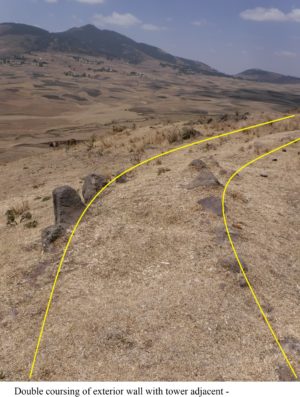
Fig. 12 – A wall alignment and architectural features – west slope, to north
___________________________
Our discoveries thus far provide a promising beginning. In our on-going exploration, no day is ever routine. Using our research template, we continue seeking and identifying lost cities and ruins strewn across Ethiopia’s magnificent and varied landscapes. Daily we are tantalized with just enough of Ethiopia’s secrets to keep us coming back for more. With every footfall, the ground seems to reverberate this noble history’s sheer will to be reborn.
Thus, regarding our regions in Africa, it appears the Fra Mauro map has proven itself far more than the fanciful rendering of a medieval mind. It is indeed a prescient icon of a Mappa Mundi that launched thousands of ships which literally turned our view of the world upside down within a single generation, eventually expanding it by four new continents. It simply requires professionals to interpret and decode this medieval, African geography.
A Call for More African-based Research
Questions inevitably remain pertaining to the poorly understood, yet complex subjects around ancient and medieval studies within Ethiopia and the broader regional contexts. Ethiopia must be reminded of the larger, deeper significance of its own history and heritage and take its rightful place in the histories of civilizations. The traditional narrative of selecting only Aksum, then Lalibela, then Gondor, as the definitive and only “history” of Ethiopia limits her capacity to address so many of her current growing pains toward a modern nation-state. The mysterious, forgotten past that paints all of Ethiopia’s landscapes in myriad colors of the impossible, should inspire us. The brilliance of such varied, interred, newly-discovered empires whisper their faded splendor to all who still intently seek it.
To better understand our commonality and connectivity beyond modern or traditional boundaries, we must investigate, validate, and honor indigenous self-perceptions within linguistic, historical, national, and individual frameworks. All will benefit from the cross-pollination of worldviews originating within this wide-ranging, local historical discourse.
I remain hopeful that eventually, with properly trained, competent public servants in the emerging culture/heritage, research, and tourism sectors, Ethiopia’s cadre of new cultural resource management professionals, archaeologists, and heritage specialists will be successful in preserving and presenting Ethiopia’s rich cultures and deep heritage. I envision the next wave of exploration, discovery, and excavation under the skillful hands and careful eyes of trustworthy Ethiopian cultural resource management experts and archaeologists.
Meanwhile, my colleagues and I wait. As does a young girl sitting in the shade of a spreading fig tree, watching her goats graze among the hundreds of tombs on the slopes of Barara, ready to learn what it means that she is offspring of some of the most powerful and impressive empires sub-Saharan Africa has ever known. And herein remains the dream. This child, and so many others like her, waiting in the shadow of her heritage, may soon learn to apprehend her broader Ethiopian heritage in true ways. May she continue to visualize her emerging story of identity, as we carefully excavate and reveal these hidden, neglected jewels of past magnificence.
Next steps
The next steps require that the ministries directly engaged in higher education and heritage and culture create an independent agency of professional cultural resource management (CRM) personnel to begin to adequately train indigenous scholars and accurately address Ethiopia’s broader archaeological and heritage potentials. Ethiopia currently is forfeiting many positive applications of heritage in terms of social/economic development or national unity and identity formation, not to mention the lost foreign currency revenues from inadequate implementation of these best practices.
Past failures of heritage leadership to grasp the changing nature of cultural resources and heritage management issues has led to the destruction of untold archaeological and heritage resources and cultural materials. It has also limited equitable access for Ethiopian scholars to research and/or to be trained in the necessary acquisition of the specialized skills of comprehensive field survey or excavation management in order to be proficient practitioners in their fields.
Much of the blame for the current misinformation and political ambiguity surrounding the case of the location and identity of Barara and related sites is the result of this leadership not comprehending or applying best practices and modern principles to heritage management. An independent and honest broker could manage heritage in ways currently beyond the scope or capacity of existing agencies. Through allowing an independent and capable cultural resource team to adopt and implement best practices in the phased approach to heritage management of creating desk-based analyses for each site and conducting comprehensive field-walking surveys to include sub-surface/geophysical survey and remote sensing analysis, Ethiopia’s heritage and archaeological potentials will rock the world.
The primary focus of heritage-related research must, therefore, focus upon training and equipping local field experts, not solely the needs of external academics. Our continual research goals are to train professional Ethiopian Cultural Resource Management Teams (CRMT) to transmit and replicate that specialized knowledge, expertise and field experience of excavation and proper heritage management to qualified scholars. Only then can Ethiopia again sing her own ancient glories to the rest of the world.
____________________________
Bibliography
Bascom, J. Ed. National Atlas of Ethiopia, 3rd edition, 2015.
Boyle, D. Voyages of Discovery, Thames & Hudson, 2011.
Brotton, J. ed. Great Maps – The World’s Masterpieces Explored and Explained, DK Publishing, 2014.
-Burton, R. F. First Footsteps in East Africa or An Exploration of Harar, Dover Publications, Inc. 1987.
-Cattaneo, A. Terrarum Orbis 8 – Fra Mauro’s Mappa Mundi and Fifteenth-Century Venice, Brepolis, 2011.
-Davidson, B. The Growth of African Civilizations- East and Central Africato the Late Nineteenth Century, Longmans, 1967.
-Davidson, B. The Lost Cities of Africa, An Atlantic Monthly Press Book – Little, Brown, and Co. 1959.
-Dudd. R. E. The Adventures of Ibn Battuta – A Muslim Traveler of the 14th Century, University of California Press, 1989.
-Edson, E. The World Map 1300-1492 The Persistence of Tradition and Tranformation, The Johns Hopkins Univeristy Press, 2007.
-Falchetta, P. Terrarum Orbis 5 – Fra Mauro’s World Map, With a Commentary and Translation of the Inscriptions, Brepolis, 2006.
-Hibbert, C. Africa Explored – Europeans in the Dark Continent 1769-1889, Penguin Books, 1984.
-Hugh, C, ed. (1911). “Unyamwezi“. Encyclopædia Britannica. 27 (11th ed.). Cambridge University Press. pp. 781–782.
-Newman, J. L. The Peopling of Africa – A Geographic Interpretation, Yale University Press, 1995.
-Pearson, M. N. Port Cities and Intruders – The Swahili Coast, India, and Portugal in the Early Modern Era, The Johns Hopkins University Press, 1998.
– Sergew, H. S. Ancient and Medieval Ethiopian History to 1270, Addis Ababa, 1972.
– Sharf, F. A. Abyssinia 1867-1868: Artists on Campaign, McMullen Museum of Art, 2007.
– Van den Bosch, G. Maps on the legend of Prester John, BIMCC Newsletter No. 29. pps.19-24. 2007.
– Welsby, D. A. & Daniels, C. M. Soba – Archaeological Research at a Medieval Capital on the Blue Nile, British Institute of East Africa, 1991.
-Whitfield, P. The Charting of the Oceans – Ten Centuries of Maritime Maps, Pomegranate Artbooks, 1996.
-Williams, F. M. Understanding Ethiopia – Geology and Scenery, Springer, 2016.
Web Sources
– http://cartographic-images.net/Cartographic_Images/249_Fra_Mauros_Mappamundi.html (Siebold, J. Monograph #249)
– https://en.wikipedia.org/wiki/Bunyoro
– https://en.wikipedia.org/wiki/Kingdom_of_Karagwe
– (Cary 1811) – http://www.raremaps.com/gallery/enlarge/33908
– (Coronelli 1690) – http://www.geographicus.com/P/AntiqueMap/Abissinia-coronelli-1690
– Fra Mauro 1450) – https://upload.wikimedia.org/wikipedia/commons/1/1b/FraMauroDetailedMap.jpg
– (Munster, 1554) – https://libweb5.princeton.edu/visual_materials/maps/websites/africa/maps-continent/1554munster.jpg
– (NASA Comparative map) – https://landsat.gsfc.nasa.gov/fra-mauros-mappamundi/
– (Pantocrator map) http://www.bl.uk/learning/timeline/item99816.html (Pinkerton 1818) –http://www.geographicus.com/P/AntiqueMap/Abyssinia-pinkerton-1818
– (Ptolemy Map) – https://upload.wikimedia.org/wikipedia/commons/f/f0/Claudius_Ptolemy-_The_World.jpg


