Ammaia, Portugal—Today there are only a few visible reminders of this ancient community. In one place, looking like the dilapidated form of a great, round chimney, what remains of an early 2nd century AD round tower juts glaringly upward from the corner of an area that features the architectural remnants of what in its heyday must have been an impressive gateway entrance for this long vanished ancient Roman town. It was part of a twin-towered structure known as the Porta Sul, or Southern Gate. Well used during its time, one can still clearly see the ruts in the granite block paving stones of the gate threshold, a testament to the many carts with heavy loads that passed this way into the town almost 2,000 years ago. It would have led the common visitor into an expansive monumental square, or courtyard. Today, not much remains to be seen, compared to the full splendor of its appearance during its heyday. But one can still see the large granite block paving stones, and standing pillar sections defining its perimeter. Nearby are exposed parts of the ancient city wall, and not far away are the visible traces of a great Roman bathhouse and evidence of the core of a temple podium that once supported the temple of the central town forum complex.
The town’s standing ruins, though modest in scale as compared to the great monumental remains of other Roman centers and cities, were noted by Spanish and Portuguese historians in the sixteenth century. But the name of the town remained a mystery, until Leite de Vasconcelos identified it as Ammaia in 1935 in a paper about an honorific inscription found at the site dedicated to the Emperor Claudius.
Seeing the Unseen
Excavations have been carried out more or less continuously at the site since the early 1990’s. But the excavations could only be limited. The remains of Ammaia sit in protective status within a nature reserve. Thus, the biggest revelations about Ammaia didn’t begin emerging until after 2009, with the launch of the Radio-Past (an acronym for Radiography of the Past) project under the coordinative co-direction of Cristina Corsi of the Universita degli Studi di Cassino, Italy, and Frank Vermeulen of the Universiteit Gent in Belgium. As a marshalling of the collective efforts of a consortium of European institutions, spearheaded by the University of Evora in Portugal, as well as a broad array of experts, Radio-Past approached the site with a non-invasive research strategy, collecting data not as much through traditional excavation as through the application of technology and a multi-disciplinary plan to, in essence, ‘see’ what was hidden beneath the surface without digging it up.
Said Cristina Corsi, co-director of the project, “this project allowed some of the most skilled European specialists of different fields to join their resources and work together on a project that involved theoretical and methodological elaboration, the definition of guidelines for good practice in many fields related to the ‘understanding’ of deserted complex archaeological sites, enhancement of fieldwork and data-capture techniques, sophisticated data-processing, development of innovative visualization techniques and management plans, and training and transfer of knowledge and dissemination at several levels.”
In other words, Ammaia became an open lab for testing an integrated ‘hands-off” approach to archaeological discovery—an undertaking they hoped would become a model for future efforts.
By applying combined and integrated state-of-the-art techniques of remote sensing, such as laser LiDAR (Light Detection and Ranging) scanning, topographical survey with global positioning systems, geophysical surveys using magnetic gradiometry and Ground Penetrating Radar (GPR), surface surveys of artifacts, as well as ‘ground truthing’ of the applications through systematic, limited targeted excavation and artifact analysis, the researchers were able to develop a set of data to visually reconstruct the ancient town as it existed in its time. What they found was a town that appeared to have been carefully planned or developed over time, including:
—a wall circuit that enclosed the town proper;
—the main road network leading into and outside of the town;
—necropoleis outside of the town, as well as industrial, production centers or sectors in the suburban outskirts;
—the street grid system within the town, at least some of which likely featured flanking, streetside porticoes with tabernae and arcades;
—in amazing detail, the reconstruction of the main public places and monuments of the town, including the forum and its temple, the public baths, and the southern gate and its associated square; and
—the town block plans, with their houses and shops.
“What we can see through the “radiography of the subsoil” is a town carefully planned, according to a regular grid,” stated Corsi. “In different sectors we have been able not only to distinguish easily all essential walls, floors and even columns, but also other meaningful linear structures, such as local aqueducts or drainage systems, and the associated basins, fountains, impluvia or cisterns, and sometimes even ovens, cooking installations and hypocausts, the “heating systems” of Antiquity.”*
The payoff was clearly extraordinary. But there was more.
With the data obtained, the team was able to create images and an interactive, video reconstruction of the town using high resolution digital processing, visualizations and interpretation.
__________________________________________
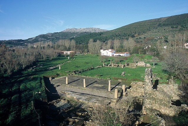
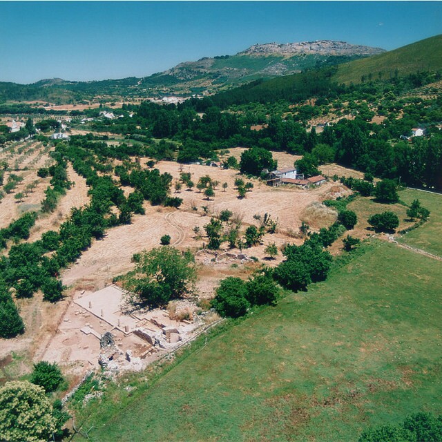 Aerial view of Ammaia, showing some excavated areas. Courtesy Radio-Past
________________________________________________________
 View of the Porta Sul, or Southern Gate complex, as excavated. Courtesy Radio-Past
________________________________________________________
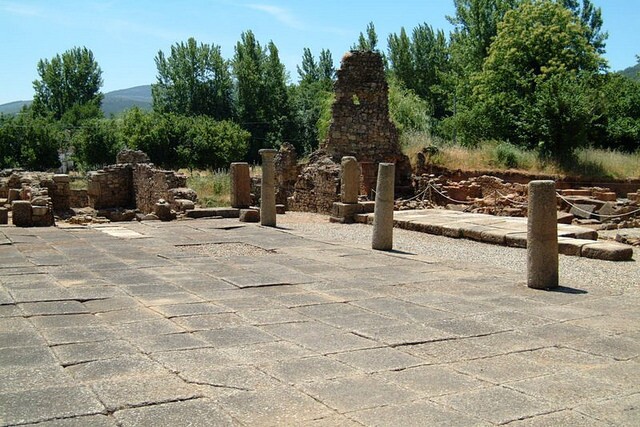 Ground level view of the Porta Sul. Courtesy Radio-Past
___________________________________________
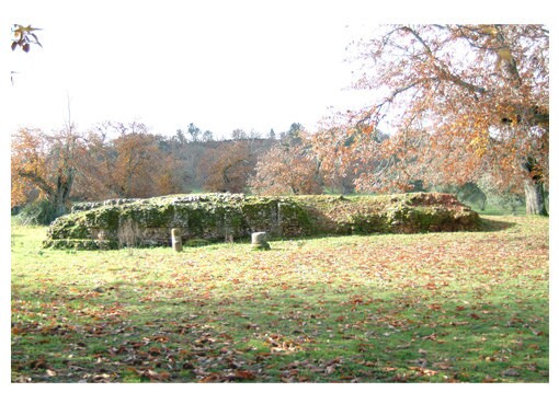 Temple remains in the forum area of Ammaia. Courtesy Radio-Past
_________________________________________________________
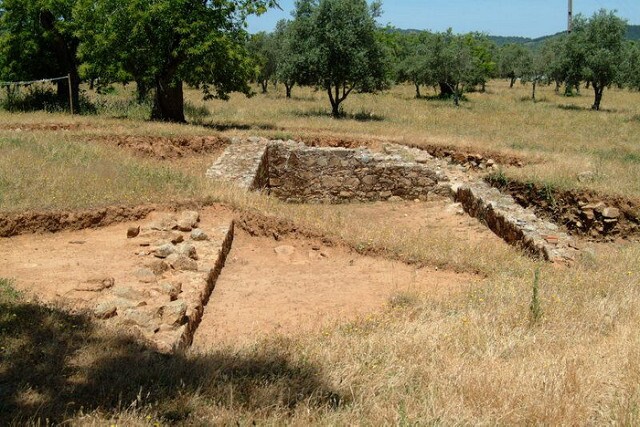 Some of the remains of the forum, as excavated. Courtesy Radio-Past
___________________________________________
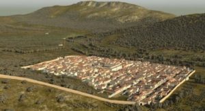
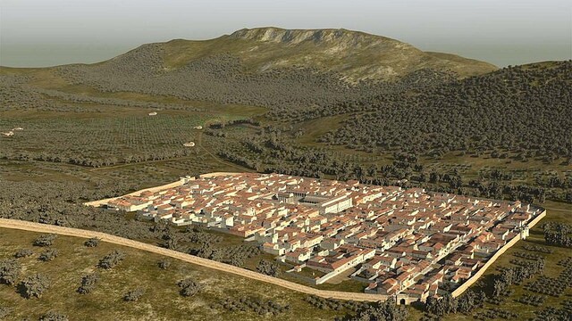 Aerial northwest overview rendering of reconstructed town of Ammaia. Courtesy 7reasons
_______________________________________________________
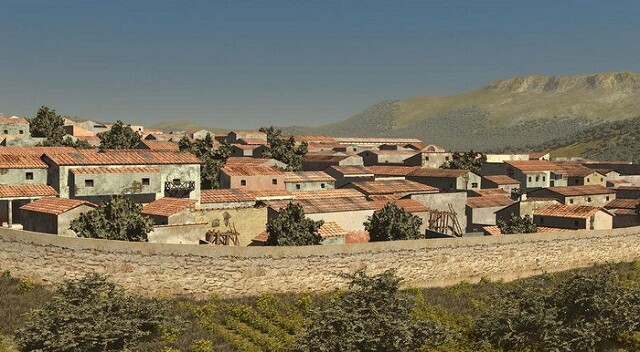 Southwest view rendering of the city wall. Courtesy 7reasons
__________________________________________________________
 Rendering of the South Gate of the city wall. Courtesy 7reasons
__________________________________________________________
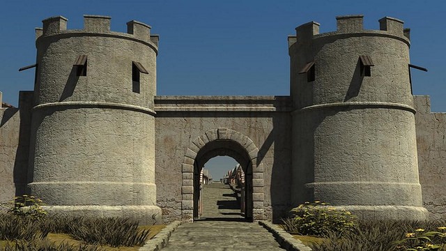
 Rendering of the internal view of the South Gate. Courtesy 7reasons
____________________________________________________________
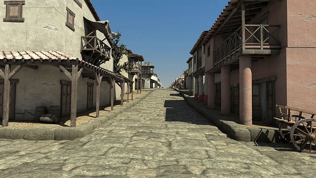 Street view of the south part of the city. Courtesy 7reasons
___________________________________________________________
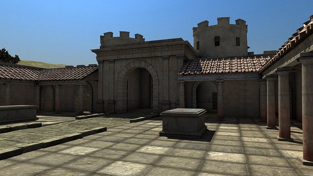
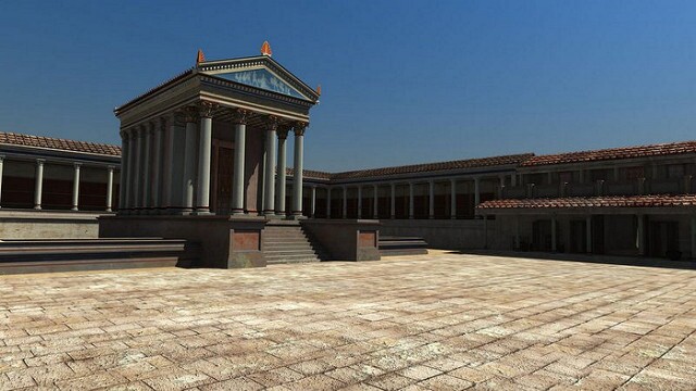 The forum and its temple. Courtesy 7reasons
____________________________________________________________
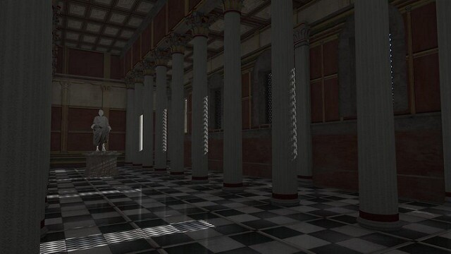 Internal view of the Basilica. Courtesy7reasons
___________________________________________________________
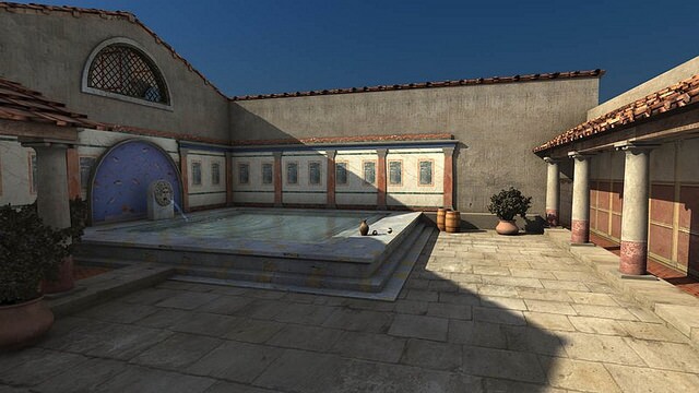
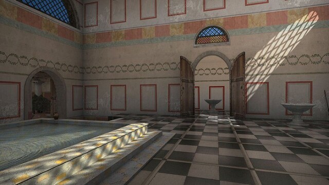 Internal detail of the baths. Courtesy 7reasons
________________________________________________________
 East part of the baths. Courtesy 7reasons
__________________________________________________________
Clarifying the Place of Ammaia in History
In addition, according to Corsi and her colleagues, the continuing study and analysis of archaeological finds and the archaeological record have further elucidated the significance and historical context of Ammaia.
“Analysis of the archaeological record collected so far allows us to propose for Ammaia a foundation during the Principate of Augustus, possibly in the last years of the first century BC or the very beginning of the new Era,” writes Corsi.*
In an expanding empire, Ammaia was established as a settlement that would function as a center from which the surrounding land and resources would be exploited, strategically placed at the junction within a road network that connected the inner and coastal areas of the new Roman province of Lusitania. It continued to flourish during the 2nd and 3rd centuries CE, but then gradually declined and fell to abandonment after the 5th century. “Recent excavations have shown that some parts were already covered by floods and slope deposits during the Late Antique period,” states Corsi in a recent publication* But in its heyday, it must have served as an important mid-sized economic and cultural center for citizens of the Roman province, as testified by the remains of a typical Roman forum complex that characterized the center of the town, along with its monumental temple and nearby bath complex and the monumental gate, public square area at the entrance to the town, and extensive urban residential structures, tabernae, arcades and shops. As the town is largely absent from the ancient historical sources, it has thus only been through archaeological investigation and the recent application of the non-invasive technologies and resulting state-of-the-art visualization techniques that have informed the re-discovery of this important site, placing it on the map of Roman civilization during the Imperial period.
______________________________________________
Ammaia and the Future of Non-invasive Archaeology
Perhaps most importantly, Radio-Past’s work at Ammaia has represented a new model for archaeologists and other researchers looking to tease the detailed information they need from archaeological sites around the world, particularly in terms of expanding our knowledge of the past without incurring the enormous costs and physical destruction of the sites that have traditionally been required.
“For the first time a complete Roman city was investigated and virtually reconstructed based mostly on the results of non-invasive investigations,” said Cornelius Meyer of Eastern Atlas GMBH & Co. KG, a major player in the project. “The result is not only of scientific interest, but it can be directly used for the wider public, as well.”
Adds Corsi, “It is proof that astonishing knowledge can be acquired about ancient settlements without excavation, and that the non-specialist public can enjoy and share this knowledge, thanks to digital technologies.”
Corsi, Vermeulen, and Meyer and their colleagues thus hope that, beyond the obvious contributions that technology-based, non-invasive approaches can make to archaeological research and the scholarly community, it can open up a whole new world, like a visual time machine, for anyone who wants to virtually ‘see’ the past with accurate graphic clarity.
What is next for Radio-Past? Meyer of Eastern Atlas spelled it out:
“We are planning to work at other ancient cities, where predominantly non-invasive strategies for their investigation will be applied,” he said. “In June and July of 2015 we will work on a research project together with Barcelona University on the Roman town of Pollentia (Mallorca); and another project will involve the investigation of the Hellenistic site of Sikyon in the northern Peloponnesus in Greece, a joint project with the University of Kiel and the Danish Institute at Athens.”
Interested readers can see Radio-Past’s website for more information about their work and projects.
_______________________________________________________
The partners involved in the Ammaia project include the Universidade de Évora, the Universiteit Gent, the British School at Rome, the University of Ljublijana, Past2Present, 7reasons, and Eastern Atlas
The project was funded by the European Union from the 7th EU Framework Programme for Research and Technological Development under the action scheme FP7, Marie Curie/People IAPP 2008.
*Ammaia, A Roman Town in Lusitania, publication presented by Radio-Past (Radiography of the Past), 2013
_______________________________________________________