
Cueva Negra is 10 km south of Caravaca de la Cruz, lying at 740 m a.s.l. (metres above sea level) and 40 m above the R. Quípar where it flows northwards out of a gorge (“Estrecho”) below the hamlet of La Encarnación (Fig.1). The large rock-shelter contains a noteworthy depth of Pleistocene sediments cursorily explored in 1981 (Martínez-Andreu et al., 1989). It lies in Upper Miocene (Tortonian) sedimentary “biocalcarenite”1 rock on the right-hand side of the narrow gorge through which the R. Quípar Gorge descends before joining the R. Segura, which reaches the Mediterranean Sea 110 km east of the site that nevertheless is but 75 km north of the southern Murcian coast. Systematic excavation began in 1990 and 25 field seasons have taken place. For some years neither the chronology nor the complexity of the Pleistocene geology were understood correctly. Inaccuracies and mistaken interpretations in earlier publications were corrected in the 2013 revision (Walker et al., 2013) that supersedes them all, and significant aspects of it are summarized here (earlier publications cited here are preceded by ! indicating they contain some unreliable information, usually a chronological attribution that is too young, sometimes incorrect faunal assignation, or occasionally a geological error).
___________________________________________
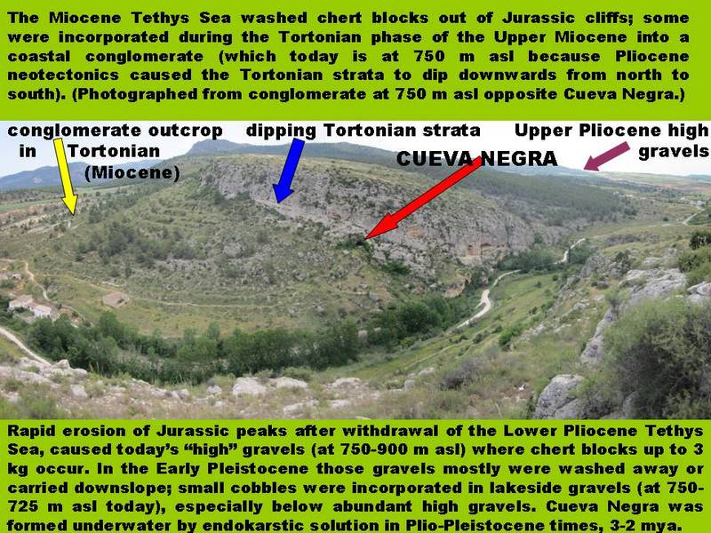 Fig. 1: Cueva Negra and its surroundings
_____________________________________________
The 5-m-deep Pleistocene sedimentary fill (Fig.2) is assigned by magnetostratigraphy2 to the Matuyama magnetochron2 >0.78 Ma (Scott and Gibert, 2009). Optically-stimulated sediment luminescence3 implies >0.5 Ma and mammalian biochronology indicates >0.7<1 Ma (Walker et al., 2013): e.g., extinct forms of Arvicolid rodents – i.e. voles, field-mice, water-rats, etc. – which became extinct around 0.7 Ma, such as Mimomys savini, Microtus (Iberomys/Terricola/Pitymys) huescarensis huescarensis, Pliomys episcopalism, Allophaiomys (Microtus/Euphaiomys) cf. chalinei, Stenocranius (Microtus) gregaloides; as well as extinct large mammals, among them the extinct Cervids Megaloceros aff. savini (a giant deer) and Dama cf. nestii vallonnetensis (an ancestral form of fallow deer); the extinct Rhinocerotid (i.e. rhino) Stephanorhinus cf. etruscus; the Equid Equus altidens (an extinct horse), etc.: all of them are well-known Pleistocene time-markers of mammalian evolution in western Europe. Sediment micromorphology4 shows the fill represents near-horizontal, gradual, intermittent fluviatile accumulation4 (Angelucci et al., 2013) with no significant horizontal or vertical discontinuities (pace Jiménez-Arias et al., 2011). Mammals, birds (including waterfowl), reptiles and amphibians corroborate pollen (! Carrión et al., 2003) typical of mild (MIS-21?5), damp, fluvio-lacustrine4 environments. Anne Eastham identified more than 60 bird species (! Walker et al., 1998) implying nearby biotopes6 of (1) lakes and rivers with temperate woodland, (2) open mixed woodland, (3) open grassland and heath, and (4) craggy mountainsides. That suggests the site was frequented owing to its well-favoured position in its surroundings with noteworthy biodiversity, though it may have been taken over by birds whenever flooding required mammals to abandon the cave, perhaps seasonally.
____________________________________________
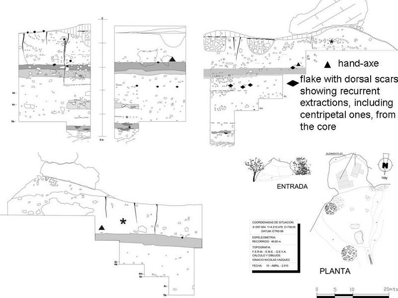 Fig. 2: Cueva Negra Plan and sections
___________________________________________
Cueva Negra “pre-Neanderthal” (Homo cf. heidelbergensis) teeth (Fig.3) give several measurements (Table 1) out with modern ranges; e.g. large antero-posterior measurement at the neck, or cervix, between crown and root (cervical vestibulo- or bucco-lingual dimension), typical in Neanderthals and archaic humans and often interpreted as a “buttressing” adaptation to using front teeth as a vise. Extreme tooth wear (attrition) of Cueva Negra front teeth, exposing dentine and the pulp- or root canal (rendering lingual crown height unreliable and uninformative) is also typical of Neanderthals and archaic humans, perhaps caused by using front teeth as a vise; in modern humans tooth wear and exposure of dentine occurs mostly on crowns of back teeth, only rarely on front teeth. One incisor tooth crown has a “shovel” form (a broad vertical scoop) on its internal (lingual) surface; “shoveling” is common on Neanderthal incisors. A canine tooth with occlusal attrition that exposed the pulp canal has a root that is much longer than in modern humans though comparable in length with some Neanderthal canines (e.g. from Grotte d’Hortus).
______________________________________________
 Fig. 3: Cueva Negra with hand-axe and teeth
|
Table 1 Cueva Negra fossil human teeth by type, metre-square, layer and spit (right), and measurements taken (below)
|
Left mandibular permanent lateral incisor B1i (1) |
left maxillary permanent lateral incisor B2f (1-2) |
left maxillary permanent canine C3e(2c) |
right mandibular permanent anterior premolar C2e(3ñ) |
Right maxillary permanent anterior premolar C1a (1-2) |
Anterior permanent tooth root C4g(2c) |
|
incisoapical height |
23.0 mm |
25.2 mm |
27.2 mm |
21.9 mm |
22.9 mm |
no crown |
|
mesiodistal crown dimensión |
5.7 mm |
7.6 mm |
7.0 mm |
11.8 mm |
6.2 mm |
no crown |
|
buccolingual crown dimensión |
7.9 mm |
9.6 mm |
7.8 mm |
8.0 mm |
7.6 mm |
no crown |
|
buccal crown height |
7.7 mm |
9.6 mm |
8.2 mm |
9.4 mm |
10.4 mm |
no crown |
|
lingual crown height |
6.1 mm |
unreliable |
unreliable |
unreliable |
Unreliable |
no crown |
|
buccal height of root |
15.3 mm |
7.9 mm |
19.0 mm |
14.3 mm |
14.6 mm |
22.5 mm |
|
mesiodistal dimension at neck |
5.4 mm |
5.8 mm |
6.5 mm |
4.6 mm |
5.5 mm |
7.3 mm |
|
buccolingual dimension at neck
|
7.7 mm |
7.8 mm |
8.0 mm |
7.7 mm |
7.0 mm |
8.1 mm |
|
maximal mesiodistal dimension of root |
5.0 mm |
5.3 mm |
5.3 mm |
3.7 mm |
5.0 mm |
5.5 mm |
|
maximal buccolingual dimension of root |
8.3 mm |
8.7 mm |
8.0 mm |
6.5 mm |
6.9 mm |
7.6 mm |
Table 1
___________________________________________
The most important findings at Cueva Negra concern human activity. Two aspects are of especial interest. First, undoubted evidence of fire has been uncovered (Fig.4), sealed within a 4.5 m-deep layer of sediment 5 m back from the present entrance, perhaps still further back 0.8 Ma if rock overhanging the entrance has undergone erosion since then. Thin-section micromorphology suggests combustion of sediment (Angelucci et al., 2013) and recent geochemical analysis supports that. Since 2011 excavation has yielded both thermally-altered, lustreless chert, with pot-lid fractures and conjoined splintering caused by thermal shock to both nodules and artificially-struck flakes, and also charred burnt animal bone and white calcined fragments showing conjoined lengthwise long-bone spalling typical of circumferential shrinkage after thermal volatilization of organic components (Walker et al., 2013). Recent taphonomical analysis and electron microscopy of bone fragments attribute discolouration to burning, not to post-depositional mineral staining, and both Fourier Transform infrared spectroscopy and electron spin resonance analysis of chert and bone imply firing temperatures ca. 550ºC (Walker et al., in preparation).
______________________________________________
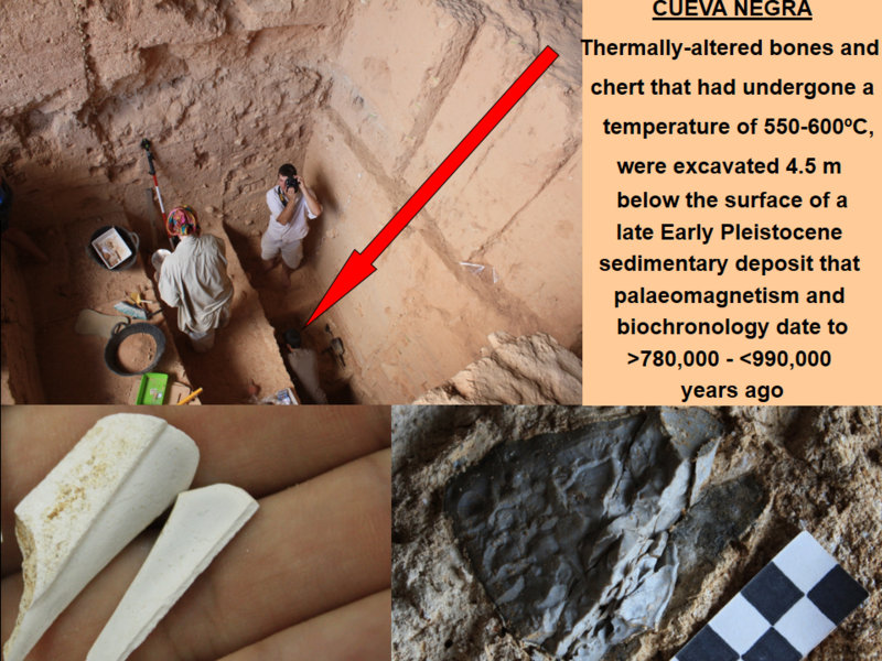 Fig. 4: Cueva Negra deep layer with thermally altered remains
____________________________________________________________
A fire-place is not a hearth. The Cueva Negra humans could have brought glowing brands left by a forest fire into the cave to establish and tend a fire where rain or wind would not put it out. They may well have been less afraid of fire outside than other animals they saw fleeing from it (which could have led them to play with fire in order to drive animals towards natural death-traps, such as swamps, enabling dismemberment and roasting). This does not mean they could reproduce or control fire; there is a dearth of archaeological evidence for hearths or fire-pits before 0.5 Ma.
Nevertheless, fire at ca. 0.8 Ma supported hominin cognitive versatility, techno-manual dexterity, and palaeoeconomic extractive behaviour in long-vanished Western European palaeoecological and palaeobiogeographical contexts. Cueva Negra exemplifies those aspects; Palaeolithic finds imply resources were exploited as far away as 40 km downstream and 30 km upstream from the site (Zack et al., 2013). That range is unsurprising given that ≥1.3 Ma early humans had begun migrating into Western Europe from northern Africa or western Asia, and therefore they could not have been congenital stick-in-the-muds even though, plausibly, their preferred habitats were localities with abundant biodiversity at hand (cf. ! Walker et al., 2006).
The excavated Palaeolithic assemblage includes a bifacially-flaked “Acheulian” limestone hand-axe, though it mostly consists of small chert, limestone or quartzite artifacts (<60 mm long), knapped on site, often by bipolar reduction or repetitive centripetal flaking of small discoidal (“Levallois”) cores, and often showing marginal retouch that is mainly steep-angle (>50º) and sometimes abrupt (“Mousteroid”), and very occasionally invasive or semi-invasive low-angle (<30º) (from the hand-axe to very small chert flakes <30 mm long). Serrated, notched or denticulate edges occur, and pieces bearing one or two large notches are common. Some flakes and several flattish or laminar subrectangular fragments were knapped to give steep abrupt (“Mousteroid”) edge-retouch (Fig.5). Steep retouch on a piece of flattish laminar chert can transform its perpendicular edge to give an acute angle useful for cutting or scraping. It is plausible to see that as being very different indeed from abrupt retouch of “scrapers” in most Mousterian assemblages where steep retouch applied to thin feathered flakes could spare them from accidental breakage by snapping during use or may have been applied to resharpen a cutting tool. Well-formed feathered flakes with striking platforms and bulbs of percussion are fairly uncommon at Cueva Negra, whereas small fragments of laminar chert abound. Many of the small artifacts seem to have much in common with those from the penecontemporaneous Catalan site of Vallparadís (Martínez et al., 2010) and from the Italian site of Isernia La Pineta, rather than with assemblages ≥1 Ma from Atapuerca and Orce.
____________________________________________
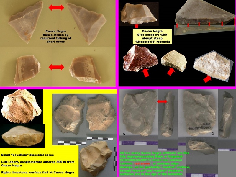 Fig. 5: Cueva Negra Palaeolithic artifacts
__________________________________________________
From a descriptive viewpoint of stone-knapping techniques the assemblage may be called “Acheulo-Levalloiso-Mousteroid” (! Walker et al., 2006; Walker et al., 2013; Zack et al., 2013); this descriptive techno-methodological approach can be uncoupled, viewed epistemologically, from prescriptive ontological typologies influenced by relative chronological inferences drawn tautologically from conjectural “culture history” and pseudo-evolutionary conjectures about Palaeolithic technology.
Once freed from the dead hand of traditional perspectives, other aspects of the assemblage come to the fore. Several small retouched artifacts seem to fall into overlapping groups, in contrast to some other Spanish Early Pleistocene assemblages that have been called “Oldowan” due to perceived similarity to African ones; the term is inappropriate at Cueva Negra because, unlike typically Oldowan artifacts in Africa, nearly all those excavated at Cueva Negra are <60 mm in size. Steep retouch is seen on many pointed pieces; some are flattish pieces and could be regarded as fine points, “awls”, or “perforators”, whereas others resemble thick “Tayac points” described often in Middle and early Late Pleistocene European assemblages. Pointed artifacts include “becs”, small chunks of chert from each of which there projects incongruously a delicate elongated tiny spur, or “beak” (fancifully bringing to mind a small bird head with its beak). There are also many steeply-keeled fragments; some resemble steep scrapers on short stumpy cores, whereas others, knapped into elongated keeled planoconvex shapes resembling garden slugs (“limaces”) may be called “proto-limaces”. Beaks and slugs could be interpreted as convergent steep scrapers, or where both ends are pointed they could be envisaged as thick double points. However, researchers at 0.7 Ma Isernia La Pineta argue that its beaks and slugs are what were left behind after their reduction by bipolar knapping to remove extremely small flakes used as unretouched tools, backing their argument up with microscopical use-wear analysis and experimental knapping (Crovetto, 1994; Crovetto et al., 1994; Peretto, 1994; Peretto et al., 2004).
Flakes produced by bipolar knapping occur at Cueva Negra, though they are yet to be quantified because quantification of bipolar elements depends on whether carinated pieces with notches, spurs (beaks) and planoconvex double-ended slug-shaped pieces, were outcomes, first and foremost, of bipolar core-reduction to remove usable flakes, or whether, instead, they were primarily fashioned intentionally for use as implements themselves. The two possibilities need not be mutually exclusive because comparable pieces have been interpreted as implements, sometimes supported by microscopical use-wear analysis; an extensive literature exists with references to “limaces”, “becs” and “microperforators” from Pleistocene and Holocene lithic assemblages in Europe, Africa, and North and South America.
Most Cueva Negra artifacts are “expedient”, frequently of “informal” shape, implying “opportunistic” or “eclectic” technological behaviour. They bring to mind the different blades of a Swiss knife. It is perhaps unsurprising that retouch is seen as often on stone fragments as on well-made flakes struck from prepared discoidal cores by recurrent repetitive centripetal flaking, given that at 0.8 Ma secant-plane control of knapping was in its infancy worldwide. It should be borne in mind that such cores are known from 1.3 Ma in Africa (de la Torre et al., 2004) where hand-axes have even greater antiquity (1.7 Ma) and that both of these involved bifacial flaking albeit with different formal secant-plane implications (asymmetrical and symmetrical, respectively), though more eclectic informal (“Oldowan”) tool-making continued alongside them. Extraction of regular flakes by recurrent repetitive centripetal flaking of prepared discoidal cores is demanding in both cognitive and technical terms (Coolidge and Wynn, 2005); the putative flakes are, as it were, “hidden” from view (like the yolk inside a hen’s egg, so to speak), and “unimaginable” simply from looking at the external shape of the stone before the reduction sequence begins. Evidence at Cueva Negra of both bifacial hand-axe production and recurrent repetitive centripetal flaking of prepared discoidal cores, together with a diverse range of small artifacts, implies manual dexterity, technical aptitude and cognitive versatility.
This raises the question of how those who frequented Cueva Negra 0.8 Ma ago perceived and exploited their surroundings, particularly where they obtained raw materials for stone tools. Two different matters are relevant. First, how far were the different possibilities of different rocks perceived? Secondly, were outcrops available then that nowadays afford suitable stone?
The hand–axe shows 30 fresh bifacial extractions on a flattish limestone cobble with some cortex still present and a similar cobble had 15 unifacial fresh extractions along one side. Both probably were obtained from fluvio-lacustrine gravels, though X-ray diffraction and petrography indicate that their grey-blue micritic limestone (94% calcite; 6% quartz) originated in Lower Jurassic (Lias) rocks (! Walker et al., 2006). An unworked cobble from Cueva Negra is a dismicrite containing 10% quartz, radiolarian fragments, and filamentous planctonic fragments, characteristic of Middle Jurassic (Dogger) strata. Lower and Middle Jurassic beds are exposed in mountainsides upstream from the site. Another unworked limestone cobble from the site lacks quartz, being oolitic sparite (oosparite). Two limestone cobbles from a small conglomerate outcrop 0.8 km east of the site also lack quartz, one being composed of cryptocrystalline limestone pellets of organic faecal origin, the other of sparite cement with microscopical fossils.
The aforementioned conglomerate outcrop is an Upper Miocene (Tortonian) marine conglomerate, containing complete Ostreid and Pectinid sea-shell fossils (i.e. oysters and scallops), that formed as an inshore deposit of Tethys Sea1 of cobbles and stones eroded out of the nearby mountainside and later cemented by CaC03 when intense Upper Pliocene and Early Pleistocene neotectonic activity lifted up the mountains and their erstwhile sea-shore to its present height of 750 m a.s.l. (the Tortonian strata dip strongly to the SW and 0.8 km away lie at 730 m a.s.l. below Cueva Negra; the steep dip was not taken into account in some early publications, leading to mistaken interpretations). The cemented cobbles and stones are of limestone, chert and quartzite; several were taken at Cueva Negra and at the outcrop Palaeolithic artifacts have been picked up similar to those of the rock-shelter, including a small prepared discoidal chert core. The chert raw material includes eroded frangible tabular nodules derived from chert blocks or slabs of sub-parallele-piped shape. They are best described as “fissible” (Stein, 1981: 537) because hammering on them often fails to elicit conchoidal fractures or produce feathered flakes with well-developed convex bulbs of percussion. If hammering does not simply shatter the chert blocks into very small chips and fragments, it may split them open along fissible flat planes defined by internal structure or impurities, and produce flattish sub-rectangular laminar fragments available for modifying as tools.
Loose chert cobbles and blocks (some upto 0.3 m across weighing 5 kg) abound <5 km south of Cueva Negra from 770 up to 890 m a.s.l. on the flanks of mountains from whose crags of Jurassic limestone chert was eroded. Massive continental lateral erosion took place in the Upper Pleistocene and initial Pleistocene, leaving high-altitude vestiges of an erstwhile vast gravel spread 100-120 m thick (“raña”; “glacis”) containing conglomerate bands, the base of which lies ca. 45 m above the river today (Walker et al., 2013; Zack et al., 2013). Later on, much of that ancient gravel was displaced both laterally and longitudinally and redeposited, owing to ongoing Early Pleistocene erosion induced by falling base level as uplift continued. The process gave rise, in two or perhaps three depositional cycles, to horizontally-bedded outcrops of gravels and fluvio-lacustrine conglomerate that abound at relative heights of 5-25 m above the river today. These outcrops often include noteworthy fossil vestiges of local lakes. The matter is complicated by unequal uplift of the sides of the active longitudinal shear fault along which the R. Quípar runs (unequal uplift saved the Cueva Negra sediments from riverine erosion), and by unequal spatiotemporal activity of those faults normal to it which probably determined development or drainage of hanging lakes upstream in the upper Quípar valley (where it is called the Rambla de Tarragoya). In short, there is a wealth of possible secondary or even tertiary sources of eroded Jurassic chert, but just which were available to Cueva Negra chert-knappers called out for forensic research.
There are also a few small primary chert outcrops. One is of radiolarite ca. 40 km downstream from the rock-shelter where a radiolarite scraper was found in 2013. Another is of light-brown tabular chert at Río Caramel, a tributary of the R. Guadalentín that joins the R. Segura near Murcia; the upper Quípar is separated by a watershed from the Guadalentín river system. It has not been possible yet to determine whether light-brown chert at Cueva Negra came from the outcrop. At high altitude on the watershed itself there is a very small outcrop of biogenic chert that probably formed in a freshwater Pliocene lake, which has the unusual frondose cactus-like form not unlike that of East African Lake Magadi flint; at least one flake at Cueva Negra may well have come from the outcrop. Primary chert outcrops seem not to have been exploited intensively.
Most Cueva Negra chert originated in Jurassic rock strata, albeit obtained from secondary or even tertiary gravel or conglomerate accumulations. Which ones? Petrographically the cherts look much alike. Might help come from chemical finger-printing of chert? Thanks to collaboration with the University of Arizona help came from the laser-ablation inductively-coupled plasma mass-spectrometry of trace elements present in several of the Earth’s crustal rocks (Sc, V, Cr, Co, Zn, Ga, Ge, Rb, Sr, Y, Zr, Nb, Cs, Ba, La, Ce, Pr, Nd, Sm). Chert samples were taken from a number of outcrops for comparison with chert from Cueva Negra (Zack et al., 2013).
Multivariate factorial analysis of the data show most chert fragments analyzed from Cueva Negra resemble chert sampled at the Tortonian conglomerate 0.8 km to the east (Fig.6). A few Cueva Negra fragments more closely resemble samples from fluvio-lacustrine gravel outcrops upstream in the Rambla de Tarragoya as far as the headwaters of the valley (where we even picked up a “proto-limace”) ca. 25 km south of the site. Plausibly, variation in trace-element composition cherts that had formed at separate localities or times in the Jurassic is reflected in compositional differences between outcrops of gravels that received chert nodules eroded from the mountainsides nearest by. Some of those cherts were taken to Cueva Negra. Trace-element characterization indicates how far humans ranged.
_________________________________________________
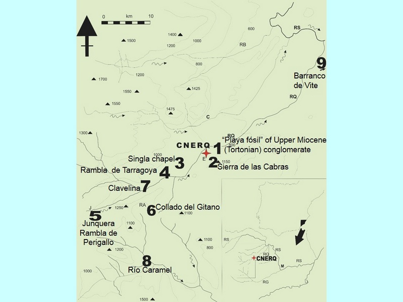 Fig. 6: Upper Quipar Valley Cueva Negra CNERQ and chart outcrops sampled
Research at Cueva Negra throws new light, including fire-light, on the cognitive versatility, manual dexterity and technical aptitude of early humans ca. 0.8 Ma in S.E. Spain. They exploited their surroundings in a competent fashion that implies precise knowledge and accurate awareness of what was available for survival. Research continues both in the field and laboratory at this intriguing late Early Pleistocene site.
___________________________________________________
Acknowledgements:
We thank all research collaborators named in the text or references as well as palaeontologists Drs. A. Ruiz Bustos, J. van der Made, X. Murélaga Beirucua and archaeologists Drs. D.A. Roe and I. Martín-Lerma for their kind help.
Footnotes:
1. This biocalcarenite rock is an Upper Miocene (Tortonian) sedimentary rock that formed between 11 and 7.5 million years ago in the bed of the vast Tethys Sea that extended from the Atlantic Ocean to the Persian Gulf (the Mediterranean Sea is all that remains of it). The rock is called biocalcarenite because it contains sand-size grains and fragments of sea-shells and coral, all cemented by calcium carbonate. It forms the floor, walls, and roof of Cueva Nega though these lack the cobbles and large pebbles that are found in more deeply lying, slightly older, Tortonian strata at a conglomerate outcrop 0.8 km E of the cave which was exploited by its Palaeolithic occupants who took cobbles to the cave and broke them open to knap the chert that some of them contained.
2. Magnetostratigraphy is the use of “geomagnetic reversals” to correlate rock strata that have been dated accurately by other means at some places. It relies on palaeomagnetic signatures of remanent magnetism in rocks, which may be based on metals (such as iron) in volcanic rocks, or on the orientation of magnetic minerals in grains in sedimentary deposits, which was the basis for the palaeomagnetic research into the Cueva Negra Pleistocene sediments. Some history is in order here. In 1906 the French geophysicist Bernard Brunhes drew attention to the phenomenon we call “geomagnetic reversal”, after finding that an ancient volcanic rock was magnetized in the opposite direction to the Earth’s present-day magnetic field. For that to have happened, he inferred that the magnetic North Pole would have to have been near to what we regard as the magnetic South Pole today, implying that our planet’s magnetic field had undergone a reversal. In 1929 the Japanese geophysicist Motonori Matuyama published findings that began to show that different reversals of the direction (“polarity”) of the Earth’s magnetic field characterize different parts of the geological stratigraphical record, and in particular that the part which we nowadays regard as the Early Pleistocene (formerly, Lower Pleistocene) was characterized by a reversal of the polarity of our planet’s magnetic field. We now know that this reversal lasted from 2.588 to 0.78 Ma: that period is called the Matuyama reverse polarity chron and it was followed by the Brunhes normal polarity chron from 0.78 Ma to the present day; the 0.78 Ma reversal is called the Matuyama-Brunhes boundary. The Matuyama chron was interrupted by a few normal polarity episodes (two important ones are named after geological beds at Olduvai and Jaramillo). The Gauss normal polarity chron mainly characterized the Upper Pliocene between 3.59 and 2.588 Ma (3.6-2.6 Ma for most intents and purposes). A few hundred reversals now are known to have taken place during the history of our planet. All of the Cueva Negra sediment corresponds to the end of the Matuyama chron, according to the results of a study of the palaeomagnetism of 11 samples taken from top to bottom of the 5 m depth of its sedimentary fill and a further 2 taken in the escarpment below the cave mouth where sediment is exposed by erosion.
3. Optically-stimulated luminscence (OSL) dating of sediment grains attempts to estimate the time elapsed since the grains were last exposed to heat (e.g. sunlight) that destabilized the chemical make-up of minerals (e.g. quartz), which over time, at a known rate, recovers part of the stability that was disturbed. If several mineral grains are used for OSL, there is a risk that some may have been exposed to light or heat at later times than others were, thereby underestimating the age of a sedimentary deposit, and this problem may have affected the OSL dates obtained on multiple-grain samples analyzed at Oxford University by Dr. Jean-Luc Schwenninger, who has made three visits to sample Cueva Negra sediments, which suggested an age of 0.3-0.4 Ma when the less reliable multiple-grain method was applied, and more recently an age of at least 0.5 Ma using single-grain analysis (Schwenninger, personal communication). Unfortunately, the time and cost involved in undertaking accelerator mass-spectrometry when single grains are used, and the obvious need to analyze several of these independently, hinder widespread application of this approach. The method is related to that of thermoluminescence, TL, that has been used to date pottery and even burnt flint for the past fifty years, often with considerable success. Dr. Schwenninger is trying to apply it to burnt chert from Cueva Negra. Put crudely, if the amount of recovery towards stability can be determined, and if also we have a fair idea of what the original firing temperature was likely to have been, then by refiring in the laboratory at that temperature a handmade prehistoric potsherd, the full degree of that ancient destabilization of physicochemical constituents of atoms in clay molecules can be reproduced, and hence, from the amount of energy we have applied in order to do so, it is possible to estimate how much time had elapsed since the original firing. Much is known about the effect on different clays caused by varying the temeprature of the potter’s kiln. The matter gets far more complicated, alas, where chert or flint underwent burning in a bonfire of unknown heat. Luckily, at Cueva Negra the burnt chert comes from a deeply-lying lens of burnt sediment containing white burnt animal bones that had undergone calcination (i.e. all organic matter in them had been burnt out), which implies heating at high temperature according to knowledge from Forensic Biology. A high temperature implies humans were tending fire in the cave, because, so far inside the cave, it is unlikely a passing bush fire could have produced it. Research into the temperature, using the method of Fourier Transform infrared spectrometry (FTIRS) on the calcined bone, is being undertaken now, with promising initial results, by geoarchaeologist Dr. Francesco Berna at Simon Fraser University, and also by Dr. Anne Skinner using electron spin resonance at Williams College at Williamstown. Their preliminary findings point to a temperature of around 550ºC.
4 Sediment micromorphology is a “geoarchaeological” technique which uses the microscope to study thin-sections of sediment samples that have been removed on site with accuracy and precision and then hardened with an impregnating agent. Microscopy can determine the size and shape of granules in the sediment, and may ascertain whether some were deposited by “fluviatile” processes, i.e. by flowing water in streams or rivers, by more sluggishly moving water in lakes or swamps (“fluvio-lacustrine”), by wind “aeolian” deposition, by volcanic ash, by organic disturbance by roots, worm-holes, or other animal activities, including human ones, etc.. It can also determine the nature of granules, whether the minerals themselves or inclusions such as small fossils, fragments of bones, shells, plants, flecks of charcoal, or even minute fragments of artifacts such as chert knapping smalls or tiny fragments of potsherds. The word “micromorphology” refers to the study of the structure or form of the sediment, which is particularly important because there may be vertical or horizontal gradations in the phenomena observed, or regular distributions may be interrupted by irregularities. Much, of course, is known about the structure of different soils and the processes underlying their formation today, but sediment micromorphology has to consider how sediments developed in long-vanished environments and climates, and knowledge of geology is fundamental in geoarchaeology.
5 Biotope refers to an area of uniform environmental conditions providing a living place for a specific assemblage or community of plants and animals. (Greek: bios = life, topos = place).
6. MIS: In the 1960’s it was found that, as igneous rocks in the bed of the ocean floor spread out from volcanically active vents in central ridges beneath the Atlantic and Pacific Oceans, they may come to lie in the position of zonal bands, formed sequentially over time, that lie parallel to a ridge. They can offer us information about geomagnetic reversals in the polarity of the planet’s magnetic field at the time they were extruded from the Earth’s molten core. The atomic clock can be used to date many of them when they have been sampled by deep-sea cores. Furthermore, the cores shed light on the density of the sea-water around the time they were formed. This is because, by analyzing the proportion of 16O to 18O isotopes in the calcium-carbonate exoskeletons of marine foraminifers (which are protozoan life-forms), in marine sediments that formed over each new zonal band, it is possible to determine the extent to which sea-water was diluted by freshwater from melting ice-caps in warm interglacial periods, or concentrated during cold glacial periods when water with the lighter oxygen isotope was drawn up preferentially into the atmosphere and then deposited elsewhere as snow and ice, and the 40K-40A or 40A-39A “atomic clocks” help to date the palaeoclimatic oscillations. Those scientific advances, together with isotopic studies of ice from cores through the Greenland and Antarctic ice sheets, have given increasingly accurate information about the number and timing of palaeoclimatic fluctuations during the Pleistocene, when they became both relatively frequent and increasingly intense when compared with the preceding geological epochs of the Pliocene and Miocene, though others had occurred several times in our planet’s more distant past. They are designated variously as MIS or OIS, standing respectively for marine or oxygen isotope stages. Working backwards from the present interglacial (MIS-1 or OIS-1), odd numbers are used for interglacials, and even numbers for ice ages, with the slightly awkward exception of the last ice age which for various reasons, including a possible climatic amelioration, comprises stages 2, 3 and 4; thus the last interglacial period, between 0.13 and 0.118 Ma, is MIS-5 or OIS-5 (not MIS-3 or OIS-3). Biochronology and pollen analysis at ancient Pleistocene sites can give a general idea about the prevailing climatic conditions, which were mild and moist when sediments accunmulated in Cueva Negra. They imply a warm interglacial period, perhaps one that occurred about 0.8 Ma (MIS-21 or OIS-21), the tenth before the present one we are living in today. Rodent biochronology at Cueva Negra implies a time later than the end, at 0.99 Ma, of the Jaramillo normal polarity episode (1.06-0.99 Ma), in the later part of the Matuyama chron, because rodent species known in southern Spain from before that episode are not present at our site.
Legends to figures:
Fig. 1 Cueva Negra del Estrecho del Río Quípar in its surroundings.
Fig. 2 Cueva Negra del Estrecho del Río Quípar: Plan and sections.
Fig. 3 Cueva Negra del Estrecho del Río Quípar: Hand-axe, human teeth.
Fig. 4 Cueva Negra del Estrecho del Río Quípar: Deep layer with thermally altered remains.
Fig. 5 Cueva Negra del Estrecho del Río Quípar: Palaeolithic artifacts.
Fig. 6 Cueva Negra del Estrecho del Río Quípar in the Upper Quipar Valley with chert outcrops shown.
References:
Walker, M.J., Angelucci, D., Anesin, D., Berna, F., Fernández-Jalvo, Y., Haber-Uriarte, M., López-Martínez, M., Rhodes, S.E., Rodríguez-Estrella, T., Schwenninger, J-L., and Skinner, A.R. Evidence of Early Palaeolthic fire at the late Early Pleistocene site of Cueva Negra del Estrecho del Río Quípar (Caravaca de la Cruz, Murcia, Spain). In preparation for Session B53 The Archaeology of Early Fire Use, XVII UISPP Congress, Burgos. September 1-7 2014.
Angelucci, D., Anesin, D., López-Martínez, M., Haber-Uriarte, M., Rodríguez-Estrella, T., Walker, M.J., 2013. Rethinking stratigraphy and site formation of the Pleistocene deposit at Cueva Negra del Estrecho del Río Quípar (Caravaca de la Cruz, Spain). Quaternary Science Reviews 80: 195-199.
! Carrión, J.S., Yll, E.I., Walker, M.J., Legaz, A.J., Chain, C., López, A., 2003. Glacial refugia of temperate, Mediterranean and Ibero-North African flora in south-eastern Spain: new evidence from cave pollen at two Neanderthal man sites. Global Ecology and Biogeography12: 119-129.
Coolidge, F.L. and Wynn, T., 2005. Working memory, its executive functions, and the emergence of modern thinking. Cambridge Archaeological Journal 15: 5-26.
Crovetto, C., 1994, Le industrie litiche, analisi tecnico-tipologica dei reperti di scavo, in Peretto, C. (Ed.), Le Industrie Litiche del Giacimento Paleolitico di Isernia La Pineta, la Tipologia, le Tracce di Utilizzazione, la Sperimentazione, Isernia, Cosmo Iannone, “Istituto Regionale per gli Studi Storici del Molise ‘V. Cuoco’”, pp. 183-353. .
Crovetto, C., Ferrari, M., Peretto, C., Longo, L., Vianello, F., 1994. The carinated denticulates from the Palaeolithic site of Isernia La Pineta (Molise, Central Italy): tools or flaking waste? The results of the 1993 lithic experiments. Human Evolution 9: 175-207.
de la Torre, I., Mora, R., Domínguez-Rodrigo, M., de Luque, L., Alcalá, L., 2003. The Oldowan industry of Peninj and its bearing on the reconstruction of the technological skills of Lower Pleistocene hominids. Journal of Human Evolution 44: 203-224.
Jiménez-Arenas, J.M., Santonja, M., Botella, M., Palmqvist, P., 2011. The oldest handaxes in Europe: fact or artefact? Journal of Archaeological Science 38: 3340-3349.
Martínez, K., García, J., Carbonell, E., Agustí, J., Bahain, J.-J., Blain, H.-A., Burjachs, F., Cáceres, I., Duval, M., Falguères, C., Gómez, M., Huguet, R., 2010. A new Lower Pleistocene archaeological site in Europe (Vallparadís, Barcelona, Spain). Proceedings of the National Academy of Sciences 107: 5262-5267.
Martínez-Andreu, M., Montes-Bernárdez, R., San Nicolás-del Toro, M., 1989. Avance al estudio del yacimiento musteriense de la Cueva Negra de La Encarnación (Caravaca, Murcia), in Crónica XIX Congreso Nacional de Arqueología, Castellón de la Plana 1987, Ponencias y Comunicaciones Volumen I, Saragossa, Universidad de Zaragoza, Seminario de Arqueología, Secretariado de los Congresos Arqueológicos Nacionales, “Congresos Arqueológicos Nacionales”, pp. 973-983.
Peretto, C. (Ed.), 1994, Le Industrie Litiche del Giacimento Paleolitico di Isernia La Pineta, la Tipologia, le Tracce di Utilizzazione, la Sperimentazione, Isernia, Cosmo Iannone, “Istituto Regionale per gli Studi Storici del Molise ‘V. Cuoco’”.
Peretto, C., Arzarello, M., Gallotti, R., Lembo, G., Minelli, A., Hohenstein, U.T., 2004. Middle Pleistocene behavioural strategies: the contribution of Isernia La Pineta (Molise, Italy), in Baquedano, E., Rubio Jara, S. (Eds.), Miscelánea en homenaje a Emiliano Aguirre Volumen IV Arqueología, Alcalá de Henares, Museo Arqueológico Regional, “Zona Arqueológica Número 4”, pp. 368-381.
Scott, G.R. and Gibert, L., 2009. The oldest hand-axes in Europe, Nature 461: 82-85.
Stein, J. (Ed.), 1981. Random House Dictionary of the English Language The Unabridged Edition, New York, Random House, p. 537.
Walker, M.J., Angelucci, D., Anesin, D., Berna, F., Fernández-Jalvo, Y., Haber-Uriarte, M., López-Martínez, M., Rhodes, S.E., Rodríguez-Estrella, T., Schwenninger, J-L., and Skinner, A.R. Evidence of Early Palaeolthic fire at the late Early Pleistocene site of Cueva Negra del Estrecho del Río Quípar (Caravaca de la Cruz, Murcia, Spain). In preparation for Session B53 The Archaeology of Early Fire Use, XVII UISPP Congress, Burgos. September 1-7 2014.
! Walker, M.J., Gibert, J., Sánchez, F., Lombardi, A.V., Serrano, I., Eastham, A., Ribot, F., Arribas, A., Sánchez-Cabeza, J-A., García-Orellana, J., Gibert, L., Albaladejo, S., Andreu, J.A., 1998. Two SE Spanish middle palaeolithic sites with Neanderthal remains: Sima de las Palomas del Cabezo Gordo and Cueva Negra del Estrecho del Río Quípar (Murcia province). Internet Archaeology5 (autumn/winter 1998) http://intarch.ac.uk/journal/issue5/walker_index.html
! Walker, M.J., Rodríguez-Estrella, T., Carrión García, J.S., Mancheño-Jiménez, M-A., Schwenninger, J-L., López-Martínez, M., López-Jiménez, A., San Nicolás-del Toro, M., Hills, M.D., Walkling, T., 2006. Cueva Negra del Estrecho del Río Quípar (Murcia, Southeast Spain): An Acheulian and Levalloiso-Mousteroid assemblage of Palaeolithic artifacts excavated in a Middle Pleistocene faunal context with hominin skeletal remains. Eurasian Prehistory 4: 3-43.
Walker, M.J, López-Martínez, M.V., Carrión-García, J.S., Rodríguez-Estrella, T., San-Nicolás-del-Toro, M., Schwenninger, J-L., López-Jiménez, A., Ortega-Rodrigáñez, J., Haber-Uriarte, M., Polo-Camacho, J-L., García-Torres, J., Campillo-Boj, M., Avilés-Fernández, A., Zack, W., 2013. Cueva Negra del Estrecho del Río Quípar (Murcia, Spain): A late Early Pleistocene hominin site with an “Acheulo-Levalloiso-Mousteroid” Palaeolithic assemblage. Quaternary International 294: 135-159.
Zack, W., Andronikov, A., Rodríguez-Estrella, T., López-Martínez, M., Haber-Uriarte, M., Holliday, V., Lauretta, D., Walker, M.J., 2013. Stone procurement and transport at the late Early Pleistocene site of Cueva Negra del Estrecho del Río Quípar (Murcia, SE Spain). Quartär, Internationales Jahrbuch zur Eiszeitalter- und Steinzeitforschung, International Yearbook for Ice Age and Stone Age Research 60: 7-28.
Michael Walker*†, Mariano López-Martínez**†, María Haber-Uriarte***†
© All rights reserved.
*Department of Zoology and Physical Anthropology, Biology Faculty, Murcia University, Espinardo Campus Universitario Edificio 20, 30100 Murcia, Spain.
Email: [email protected]; [email protected]; “M.J.Walker” <[email protected]> Tel: 34-620-267104
**Calle Pintor Joaquín 10-4º-I, 30009 Murcia, Spain.
Email: [email protected] Tel: 34-630-408806
***Department of Prehistory, Archaeology, Ancient History, Mediaeval History and Historiographical Techniques and Science, Faculty of Letters, Murcia University, La Merced Campus, Calle Santo Cristo 1, 30001 Murcia, Spain.
Email: [email protected]; [email protected], “María Haber” <[email protected]> Tel: 629-756183
†Directors of the excavation, Murcian Association for the Study of Palaeoanthropology and the Quaternary, MUPANTQUAT web-site http:www.mupantquat.com (Murcia Archaeological Museum, Avenida Alfonso X El Sabio 7, 30008 Murcia, Spain), all correspondence to MUPANTQUAT Secretary M.López Martínez <[email protected]>), and
†Murcia University Experimental Sciences Research Group E005-11 “Quaternary Palaeoecology, Palaeoanthropology and Technology” (c/o Dr.J.S.Carrión García, Department of Plant Biology (Botany), Biology Faculty, Murcia University, Espinardo Campus Edificio 20, 30100 Murcia, Spain)


