
Walking through this lush, tropical forest, visitors may not realize at first that they are among the monumental remains of a large ancient Maya center. Where are all the great stone pyramids, ball-courts, temples, and other monuments so often attributed to great ancient Maya centers? Yet, one sees a tropical landscape that is anything but flat. There is a jungle-shrouded mound here, another one over there. A well-planned walking path winds through what a visitor might describe as the Maya version of the Garden of Eden. Like the very first 18th and 19th century explorers of the Maya world, one sees what could be ancient structures still hidden beneath their canopy shroud. Some of them here have now been partially exposed, betraying what might lie beneath and leaving the rest to the imagination. Visitors soon acquire the impression that this place is very different than any other encountered in the Maya world. Straddling the border between Guatemala and Belize, it is known as El Pilar. It has been explored and studied by archaeologist Dr. Anabel Ford of the University of California, Santa Barbara for decades.
“Based on excavations exposures, several key locales at El Pilar have been consolidated for viewing under the forest canopy, while most have been preserved under a mantel of earth for later consideration,” wrote Ford and co-author Maggie Knapp in a previous article about the site*. “Partial exposures offer examples of the monumental architecture, while the covered temples can be compared with those exposed at other sites. The objective of Archaeology under the Canopy [the program plan for excavating and researching El Pilar] is to maintain architectural harmony and integrity and to give priority to the monuments at risk.” With this approach, Ford hopes to better preserve the site’s monumental features, sustaining the stability of the structures that otherwise would deteriorate due to environmental temperature, humidity, and precipitation effects — all factors that erode plaster walls and the delicate, elaborate facades that characterize ancient Maya works.
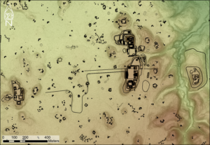
Thus, most of the monumental features of this ancient city remain ‘hidden’ beneath its tropical forest shroud. But now, teams of researchers, led by Ford, have recently undertaken a new way of “seeing” the ancient settlement and its surrounding context with high-tech eyes, significantly expanding their understanding of the true complexity and size of its otherwise ‘invisible’ human-modified landscape.
“We have integrated LiDAR imagery into settlement surveys for seven years to examine the landscape beyond “downtown” El Pilar,” writes Ford and her team of researchers about their recent research**. LiDAR is a method for measuring distances in the topography of an area by directing laser light from aerial positions to the surface and then measuring its reflection with a sensor. The differences in laser return times and wavelengths are then applied to mapping technology to create digital 3-D and other images of the landscape, as well as creating new data sets about the landscape.
“We have documented over 1,862 structures over the 14 square kilometers surveyed to date, with more to be added by future work,” says Ford and her colleagues**.
Much more than this, Ford and her team of researchers have also identified a variety of other features related to how the ancient inhabitants managed or modified their environment within El Pilar’s landscape ‘footprint’, including aguadas (small reservoirs), chultuns (storage pits), berms, depressions, terraces and quarries — all features that would otherwise elude the casual eye as one traverses the area on foot, but which signal site investigators where to look on the ground for evidence of the ancient peoples’ presence and activities.
Additionally, by consulting and cooperating with the indigenous people of today’s El Pilar area — the ‘citizen scientists’ — the researchers have greatly enhanced their ability to accurately interpret what they are finding. Altogether, combining the LiDAR surveys and analysis with the input and knowledge of the indigenous participants have provided a gold mine of information for analysis, promising a fuller and more detailed understanding of the settlement, agricultural activity, and clues to the lifestyle of these ancient people.
Ford believes this overall approach has important implications and significance for the study of the ancient Maya across all of Mesoamerica.
Says Ford and her colleagues: “The combination of these different ways of knowing has a synergistic effect, which deepens mutual understanding across cultures and creates a more holistic framework for conducting research, and we are excited about the direction we are headed.”**
____________________________
Map of the El Pilar core, or “city center”, made possible by LiDAR. Courtesy BRASS/El Pilar
____________________________
For more about this, see the article, Modeling Ancient Maya Landscapes, in the Winter 2021 issue of Popular Archaeology Magazine.
*El Pilar: Archaeology under the Canopy, by Anabel Ford and Maggie Knapp, Popular Archaeology Magazine, September 6, 2011.
**Modeling Ancient Maya Landscapes, by Sherman Horn, Anabel Ford, Thomas Crimmel, Justin Tran, and Jason Woo, Popular Archaeology, Jan. 10, 2021.
________________________________
Advertisement
Join Anabel Ford on this unique mega-trip to Mesoamerica!
________________________________


