Archives: Articles

This is the example article

Agriculture development and environmental records during Neolithic Age in north China

SCIENCE CHINA PRESS—China has a long tradition of agriculture production. Millet crops including foxtail millet and broomcorn millet were firstly domesticated in north China, and thereafter the development of millet-based agriculture (also called “rain-fed” agriculture) provided an important foundation for the emergence of ancient Chinese civilization, which might have also exerted an unprecedented impact on natural environments.
Previous studies revealed that the Yangtse River valley of south China and the Yellow River valley of north China were the original center of rice agriculture and rain-fed agriculture respectively. The history for the development of rain-fed agriculture during the Neolithic period has been intensively concerned, for central north China was the cradle for the origin of ancient Chinese civilization in the early 4th Millennium BP (Before present). Archaeologists have summarized the timeline for the development of rain-fed agriculture in Neolithic China, based on archaeobotanical evidences, while the space variation in this process has not been adequately studied and the spatial-temporal intensification and expansion of rain-fed agriculture in the Neolithic Age remains unclear.

The impact of slash-and-burn cultivation on the surrounding environments after the emergence of intensive rain-fed agriculture in China has also not been well understood due to the lack of interdisciplinary studies, for example, the cross-over studies between archaeology and earth sciences. The issue is valuable for the discussion of the hot-topic argument for the “Anthropocene”, which is nominated as a new geological epoch. Some scholars argue for the onset of the Anthropocene between 1945-1964 AD, when intensive atmospheric nuclear testing resulted in peak values of Carbon14, widely recorded in tree rings and sediments, while other scholars have argued its beginning may be traced back to the early Holocene. This latter argument is related to the beginnings of significant landscape modification through the development and spread of agricultural practices in the Old World since 10,000 BP.

In an article* coauthored by Guanghui Dong, Shanjia Zhang, Yishi Yang, Jianhui Chen and Fahu Chen, scholars at the MOE Key Laboratory of Western China’s Environmental System, Lanzhou University, suggest the intensification and expansion of agriculture during the Neolithic Age in northern China and its imprints in paleo-environmental records has been detected, based on the comparative analysis of multidisciplinary evidences.

These five scholars review the results of archaeobotanical and dating studies, and carbon isotope analysis of human bones from Neolithic sites, comparing them with black carbon content from palaeoenvironmental records in northern China. Based on this study, they conclude that millet cultivation was an auxiliary subsistence strategy in northern China from 10,000 to 7000 BP, with hunting-gathering the primary subsistence strategy, and that the earliest millet-cultivation might have emerged in eastern Inner Mongolia post 7700 BP. Millet cultivation transitioned from a secondary strategy to become dominant in the Guanzhong area of north-central China during 7000-6000 BP, and probably facilitated the development of early Yangshao culture in the middle reaches of the Yellow River valley. Intensive millet-based agriculture emerged and widely expanded across the Yellow River valley in northern China during 6000-4000 BP. This promoted rapid population growth and cultural evolution in the late Neolithic period, and was key to the subsequent emergence of the ancient Chinese civilization. The temporal-spatial variation of black carbon (EC-soot) corresponds well with the intensification and expansion of millet-based agriculture during Neolithic period, suggesting intensive millet agriculture production activities exerted evident impact on fire frequency in northern China.

______________________________

chinaagriculture

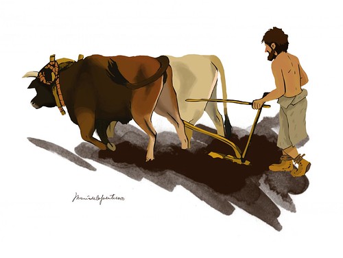
 Artist illustration of slash-and-burn cultivation during the Neolithic Age. Courtesy Science China Press

______________________________ 

This work provides a valuable case study for understanding the temporal and spatial development of millet agriculture, and human-environment interactions in northern China during the Neolithic period from an Anthropocene perspective.

Source: Adapted and edited from the subject Science China Press news release

_________________________________________

*Dong G H, Zhang S J, Yang Y S, Chen J H, Chen F H. Agricultural intensification and its impact on environment during Neolithic Age in northern China (in Chinese). Chin. Sci. Bull., 2016, 61: 2913-2925, doi: 10.1360/N972016-00547.

_________________________________________

oldcoverpic

Read more in-depth articles about archaeology with a premium subscription to Popular Archaeology Magazine. 


 ______________________________________________


Travel and learn with Far Horizons.

farhorizons1

____________________________________________

winter2016ebookcover

 This richly illustrated issue includes the following stories: Recent findings shedding new light on the whereabouts of the remains of Philip of Macedon, father of Alexander the Great; how an archaeologist-sculptor is bringing bones of the dead back to life; archaeologists uncovering town life at the dawn of civilization; an exclusive interview with internationally acclaimed archaeologist James M. Adovasio about what makes the Meadowcroft Rockshelter prominent in the ongoing search for the first Americans; what archaeologists are finding at the site of the ancient city of Gath, the home town of the biblical Philistine giant, Goliath; and how scientists are redrawing the picture of human evolution in Europe.  Find it on Amazon.com.


Unique skin impressions of the last dinosaurs discovered in Barcelona

UNIVERSITAT AUTONOMA DE BARCELONA—A geological research conducted in the village of Vallcebre, near Barcelona, to study the origins of rock sediments from the Late Cretaceous period (approx. 66 million years ago) has revealed an extraordinary artifact. Researchers discovered the impression of skin scales left by a dinosaur which had lain down in the mud. During that period, the area was a muddy region corresponding to the banks of a river. As chance had it, that muddy region where the animal’s scales had left their mark was later covered with sand which, in the course of thousands of years, finally petrified to form sandstone and thus become the sedimentary rock which preserves the impression recently discovered by the researchers. The sand acted as a mould and therefore, what actually can be seen on the rock is not really the impression, but the relief of the animal’s original skin.

The characteristics of the discovery are unique, given that the Late Cretaceous period corresponds to the moment short before dinosaurs became extinct, there are few places on Earth containing sandstone from this period, and characterizing these dinosaurs is very important in order to understand how and why they disappeared. “This is the only registry of dinosaur skin from this period in all of Europe, and it corresponds to one of the most recent specimens, closer to the extinction event, in all of the world”, highlights UAB researcher Victor Fondevilla, main author of the research. “There are very few samples of fossilized skin registered, and the only sites with similar characteristics can be found in United States and Asia”, Fondevilla states. He goes on to say: “Other dinosaur skin fossils have been found in the Iberian Peninsula, in Portugal and Asturias, but they correspond to other more distant periods”.

The shape of the scales observed on the rock show a pattern characteristic of the skin of some dinosaurs: in a form of a rose with a central bump in the shape of a polygon, surrounded by five or six more bumps. However, the scales are large, too large for the typical size of carnivorous dinosaurs and hadrosaurs roaming this area 66 million years ago. “The fossil probably belongs to a large herbivore sauropod, maybe a titanosaurus, since we discovered footprints from the same species very close to the rock with the skin fossil” Fondevilla says.

In fact, two skin impressions were found, one measuring approximately 20 centimetres wide, and the other slightly smaller, measuring only 5 centimetres wide, separated by a 1.5 metre distance and probably made by the same animal. “The fact that they are impression fossils is evidence that the animal is from the sedimentary rock period, one of the last dinosaurs to live on the planet. When bones are discovered, dating is more complicated because they could have moved from the original sediment during all these millions of years”, Fondevilla states.

________________________________________

skinimpression

 Dinosaur skin impression on rock. Credit: Jordi Pareto/UAB

_____________________________________________________

titanosaure

 Reconstruction of a titanosaurus.  Credit: Oscar Sanisidro/Institut Català de Paleontologia Miquel Crusafont 

_________________________________________ 

The finding verifies the excellent fossil registry of the Pyrenees in terms of dinosaurs living in Europe little before they became extinct throughout the planet. “The sites in Berguedà, Pallars Jussà, Alt Urgell and La Noguera, in Catalonia, have provided proof of five different groups of dinosaurs: titanosaurs, ankylosaurids, theropods, hadrosaurs and rhabdodontids”, explains Àngel Galobart, head of the Mesozoic research group at the ICP and director of the Museum of Conca Dellà in Isona. “The sites in the Pyrenees are very relevant from a scientific point of view, since they allow us to study the cause of their extinction in a geographic point far away from the impact of the meteorite”, Galobart explains.

The research, published in Geological Magazine, was led by Víctor Fondevilla and Oriol Oms from the UAB Department of Geology, in collaboration with Bernat Vila and Àngel Galobart, both from the Institut Català de Paleontologia Miquel Crusafont (ICP) and the Museum of Conca Dellà.

Source: Universitat Autonoma de Barcelona news release.

_______________________________________________________

oldcoverpic

Read more in-depth articles about archaeology with a premium subscription to Popular Archaeology Magazine. 


 ______________________________________________


Travel and learn with Far Horizons.

farhorizons1

____________________________________________

winter2016ebookcover

 This richly illustrated issue includes the following stories: Recent findings shedding new light on the whereabouts of the remains of Philip of Macedon, father of Alexander the Great; how an archaeologist-sculptor is bringing bones of the dead back to life; archaeologists uncovering town life at the dawn of civilization; an exclusive interview with internationally acclaimed archaeologist James M. Adovasio about what makes the Meadowcroft Rockshelter prominent in the ongoing search for the first Americans; what archaeologists are finding at the site of the ancient city of Gath, the home town of the biblical Philistine giant, Goliath; and how scientists are redrawing the picture of human evolution in Europe.  Find it on Amazon.com.


Scientists map genome of African diaspora in the Americas

UNIVERSITY OF COLORADO ANSCHUTZ MEDICAL CAMPUS—AURORA, Colo. (Oct. 11, 2016) – Researchers at the University of Colorado Anschutz Medical Campus along with colleagues at Johns Hopkins University and other institutions have conducted the largest ever genome sequencing of populations with African ancestry in the Americas.

The scientists, for the first time, have created a massive genetic catalog of the African diaspora in this hemisphere. It offers a unique window into the striking genetic variety of the population while opening the door to new ways of understanding and treating diseases specific to this group.

The study was published today in the journal Nature Communications.

“The African Diaspora in the Western Hemisphere represents one of the largest forced migrations in history and had a profound impact on genetic diversity in modern populations,” said the study’s principal investigator Kathleen Barnes, PhD, director of the Colorado Center for Personalized Medicine at CU Anschutz. “Yet this group has been largely understudied.”

Barnes said those of African ancestry in the Americas suffer a disproportionate burden of disability, disease and death from common chronic illnesses like asthma, diabetes and other ailments. The reasons why, remain largely unknown.

With that question in mind Barnes and her colleagues, with support from the NIH’s National Heart, Lung and Blood Institute, created the `Consortium on Asthma among African-ancestry Populations in the Americas’ or CAAPA. They sequenced the genome of 642 people of African ancestry from 15 North, Central and South American and Caribbean populations plus Yoruba-speaking individuals from Ibadan, Nigeria. The ultimate goal of the study is to better understand why they are more susceptible to asthma in the Americas. But the result was a wide-ranging genetic catalogue unlike any other.

The African genome is the oldest and most varied on earth. Africa is where modern humans evolved before migrating to Europe, Asia and beyond.

Barnes and her team are finding changes in the DNA of Africans in the Americas that put them at higher risk for certain diseases. Perhaps one reason for this is the amount of genetic material they carry from other populations including those of European ancestry and American Indians.

“Patterns of genetic distance and sharing of single nucleotide variations among these populations reflect the unique population histories in each of the North, Central and South American and Caribbean island destinations of West African slaves, with their particular Western European colonial and Native American populations,” the study said.

For example, the researchers showed that the mean African ancestry varied widely among populations depending on where they were settled, from 27% of Puerto Ricans to 89% of Jamaicans. In places like the Dominican Republic, Brazil, Honduras and Colombia there was also significant Native American ancestry as well.

Untangling this genetic history will take years, but Barnes said the catalogue is a good start. The data will serve as an important resource for disease mapping studies in those with African ancestry.

“This will contribute to the public database and give clinicians more information to better predict and track human disease,” Barnes said. “It will allow us to tailor clinical to specific individuals based on their ethnic and racial backgrounds.”

______________________________________

blackportrait

 Black Bashi-Bazouk: Oil on canvas in the Metropolitan Museum of Art ,2008: given by Mrs. Charles Wrightsman

_____________________________________

A companion paper demonstrating the clinical utility of the African diaspora genome catalog appears in the same issue of Nature Communications.

Source: University of Colorado Anschutz Medical Campus press release.

___________________________________________________

oldcoverpic

Read more in-depth articles about archaeology with a premium subscription to Popular Archaeology Magazine. 


 ______________________________________________


Travel and learn with Far Horizons.

farhorizons1

____________________________________________

winter2016ebookcover

 This richly illustrated issue includes the following stories: Recent findings shedding new light on the whereabouts of the remains of Philip of Macedon, father of Alexander the Great; how an archaeologist-sculptor is bringing bones of the dead back to life; archaeologists uncovering town life at the dawn of civilization; an exclusive interview with internationally acclaimed archaeologist James M. Adovasio about what makes the Meadowcroft Rockshelter prominent in the ongoing search for the first Americans; what archaeologists are finding at the site of the ancient city of Gath, the home town of the biblical Philistine giant, Goliath; and how scientists are redrawing the picture of human evolution in Europe.  Find it on Amazon.com.


Lifting the veil on Queen of Sheba’s perfume

It is one of the oldest fragrances in the world. Nicolas Baldovini’s team at the Institut de chimie de Nice (CNRS/UNS) has just discovered the components that give frankincense its distinctive odor: two molecules found for the first time in nature, named “olibanic acids” by the scientists. Their research results* have just been published online, on the website of the journal Angewandte Chemie International Edition.

It is mentioned more than twenty times in the Bible, where it is one of the gifts offered by the Three Wise Men. Frankincense (also called olibanum1), one of the world’s oldest fragrances, is a gum resin that exudes from the bark of Boswellia trees, which grow in countries bordering the Red Sea and the Gulf of Aden. It has been used for more than 6,000 years by every civilization, from Mesopotamia to the present. Regularly burned during religious ceremonies, it contributes to the very particular smell of churches. Despite its long history and the large amount of research dedicated to it, the exact nature of the molecules that give frankincense its distinctive fragrance surprisingly remained unknown.

Nicolas Baldovini and his team at the Institut de chimie de Nice (CNRS/UNS), which specializes in fragrances, have just succeeded in identifying them for the first time. The chief difficulty lay in finding methods of analysis precise enough to characterize these odorous substances, which are present in the fragrance in very small quantities (a few hundred ppm2), and therefore all the more difficult to detect.

To do so, the researchers used three kilos of essential oil of frankincense from Somalia, from which they isolated a purified sample of approximately 1 mg of two odorant constituents, through a series of distillations, extractions, and chromatography analyses. A group of researchers trained to recognize the typical odor of frankincense proved necessary to assist in this work, for only the human nose is sensitive enough to detect these constituents in small quantities in a mixture. The team then had to determine the molecular structure of these substances using nuclear magnetic resonance (NMR, the equivalent of an MRI applied to molecules). The two molecules, which give frankincense its “old church” smell have been identified as (+)-trans- and (+)-cis-2- octylcyclopropyl-1-carboxylic acids. Moreover, this is the first time that these compounds have been discovered in nature. In order to irrefutably confirm their characterization established using spectral analysis, the team then synthesized each of these components—which they named “olibanic acids” (from olibanum, another name for frankincense)—and used synthesis to demonstrate they were identical to the natural components.

_______________________________________

frankincensegumresin2

 Frankincence gum resin. Courtesy Société Albert Vieille

_______________________________________ 

Thanks to this discovery, perfume makers can now produce these molecules artificially in unlimited amounts, and use them in different perfumes. 

Source: Press release of the CNRS and the Université Nice Sofia Antipolis

____________________________________________________

Notes

1 Olibanum, a medieval Latin word, derives from the Greek ho libanos.
2 Ppm: parts per million.

*Olibanic Acids as Key Odorants of Frankincense. Céline Cerutti-Delasalle, Mohamed Mehiri, Cecilia Cagliero, Patrizia Rubiolo, Carlo Bicchi, Uwe J. Meierhenrich and Nicolas Baldovini. Angewandte Chemie International Edition. Published online on October 4, 2016 (print version forthcoming).
DOI: 10.1002/anie.201605242R2

____________________________________________________

oldcoverpic

Read more in-depth articles about archaeology with a premium subscription to Popular Archaeology Magazine. 


 ______________________________________________


Travel and learn with Far Horizons.

farhorizons1

____________________________________________

winter2016ebookcover

 This richly illustrated issue includes the following stories: Recent findings shedding new light on the whereabouts of the remains of Philip of Macedon, father of Alexander the Great; how an archaeologist-sculptor is bringing bones of the dead back to life; archaeologists uncovering town life at the dawn of civilization; an exclusive interview with internationally acclaimed archaeologist James M. Adovasio about what makes the Meadowcroft Rockshelter prominent in the ongoing search for the first Americans; what archaeologists are finding at the site of the ancient city of Gath, the home town of the biblical Philistine giant, Goliath; and how scientists are redrawing the picture of human evolution in Europe.  Find it on Amazon.com.


Uncovering Mysteries on the Isle of Mull

As Founder and Editor of Popular Archaeology Magazine, Dan is a freelance writer and journalist specializing in archaeology.  He studied anthropology and archaeology in undergraduate and graduate school and has been an active participant on archaeological excavations in the U.S. and abroad.  He is the creator and administrator of Archaeological Digs, a popular weblog about archaeological excavation and field school opportunities.  

In the summer of 2016, a small team of archaeologists and field school students could be seen carefully working the earth at the base of a steep slope on an island off the west coast of Scotland. The island, known as Mull, is one among 79 other islands in the Inner Hebrides, an archipelago just off Scotland’s picturesque west coast.

Life on Mull is simple, steeped in commercial traditions of fishing, crofting, and whisky distilling. But it also draws tourists for its picturesque seaside beauty, the colorful houses of Tobermory village, and the Tobermory distillery — including other visual remnants of a past that goes back hundreds, even thousands, of years. 

______________________________________

tobermorytorstenhenning

 A view of Tobermory. Torsten Henning, Wikimedia Commons

_______________________________________ 

The archaeological team, under the auspices of the Heritage and Archaeological Research Practice (HARP) in collaboration with the Mull Archaeology Interest Group (MAIG), is investigating the remains of a small historic settlement known as Kildavie in the North West Mull Community Woodland of Langamull. No one has lived in this place for hundreds of years, but it was occupied in the 17th and 18th centuries. The remains of sixteen buildings have been identified thus far. The archaeologists suggest they were primarily domestic dwellings, with perhaps some evidence of a cottage industry.

“There is archaeological and historic evidence that Kildavie was a domestic settlement in the 17th and 18th centuries until it was abandoned at the beginning of the 19th century,” says Kate Leonard, an archaeologist who was working at the site during the summer of 2016. “The reason for its final abandonment is unknown, as is the origin of the settlement.”

But digging and research at the site could provide some clues for answers. Who were these people and why did they leave?

There is no written history of this settlement. But some historical context could help frame the inquiry. 

“While there is a grand narrative about the Highland Clearances in this part of the country – with some very real and harrowing accounts to go along with it – the story is not straightforward in every case,” continues Leonard. “While some people were quickly forced out of their homes, other places were more gradually abandoned and Kildavie may be one of these.”  

The Highland Clearances saw the forced eviction or displacement in the 18th and 19th centuries by aristocratic landowners of a large number of people or crofters, people who made their living as tenant farmers of small parcels of land. The landowners required the land to be converted to use as grazing area for the new agricultural revolution — sheep raising and herding. Many of the evictions were brutal, and the actions had the effect of depopulating the Hebrides and displacing them to other areas of Scotland and even other countries and continents, such as the Americas and Australasia. It profoundly impacted the indigenous Gaelic culture.  

Was the fate of Kildavie the result of the Clearances?

The archaeology at the site has yet to answer this question. In the meantime, however, digging and analysis can provide clues to how these people lived and what their settlement may have looked like in the 17th and 18th centuries. 

“By excavating as wide a variety of structures as possible the team hopes to identify differences in dates of occupation and use of the structures,” says Leonard. 

“The team is also investigating the possibility that one or two of the structures were built for something other than a domestic dwelling; for instance, for a cottage industry. It also seems that some buildings were ‘renovated’ and re-used for another purpose. This type of later reuse can be seen in the small dividing walls built in some of the structures, possibly after they went out of use as a home.”

_______________________________________

kildavie3

 Sheep: A common site in the excavation area. Photo courtesy Kate Leonard 

___________________________________________________

kildavie2

 The archaeological team at work on site. Photo courtesy Kate Leonard

___________________________________________________

kildavie1

 Revealing unwritten history through archaeology: Investigation of the structures and the associated artifacts will help shed light on the functions of the structures and the lives of the people who once occupied them. Photo courtesy Kate Leonard

____________________________________________________ 

Leonard’s group excavated two small trenches. They were exploring the construction of walls and the entrance of a dry-stone built structure. “By the end of the dig we had exposed the floor layer in one trench and had revealed the structure of the wall in the other.” 

Work at the site has been an ongoing endeavor, and the team has set its sights ahead.

Concludes Leonard, “there is more work to be done and the trenches will be reopened next season so the questions we have will still be investigated.”

To learn more about the dig at Kildavie (and the other excavations HARP organizes), see their website. http://www.harparchaeology.co.uk/

_______________________________________

Leonard’s time at the excavation was for but a brief period. She moves on to Hawaii, where she will be participating in another project as part of a global year-long journey to work at twelve different archaeological sites in 12 separate countries. She calls her project Global Archaeology: A Year of Digs. Kildavie was the 9th stop on her global trek. 

Popular Archaeology will be following and reporting on Leonard’s worldwide experiences periodically throughout 2016 as she hops from one location to another during her global journey. To continue the work, however, Leonard will need financial support from donors. Readers interested in reading about and supporting her self-directed Global Archaeology crowdfunded project can learn more at gofundme.com/globalarchaeology.

You can read more about Leonard’s experience at Kildavie here.

_______________________________________

oldcoverpic

Read more in-depth articles about archaeology with a premium subscription to Popular Archaeology Magazine. 


 ______________________________________________


Travel and learn with Far Horizons.

farhorizons1

____________________________________________

winter2016ebookcover

 This richly illustrated issue includes the following stories: Recent findings shedding new light on the whereabouts of the remains of Philip of Macedon, father of Alexander the Great; how an archaeologist-sculptor is bringing bones of the dead back to life; archaeologists uncovering town life at the dawn of civilization; an exclusive interview with internationally acclaimed archaeologist James M. Adovasio about what makes the Meadowcroft Rockshelter prominent in the ongoing search for the first Americans; what archaeologists are finding at the site of the ancient city of Gath, the home town of the biblical Philistine giant, Goliath; and how scientists are redrawing the picture of human evolution in Europe.  Find it on Amazon.com.


Archaeologists unveil new findings from Greek warrior’s tomb

UNIVERSITY OF CINCINNATI—When University of Cincinnati researchers uncovered the tomb of a Bronze Age warrior—left untouched for more than 3,500 years and packed with a spectacular array of precious jewelry, weapons and riches—the discovery was hailed by experts as “the find of a lifetime.”

Now, only a year after archaeologists completed the excavation, new understandings of the artifacts—particularly the discovery of four golden rings—and the insights they provide to the origins of Greek civilization may prove to be the team’s next big discovery.

Shari Stocker, a senior research associate in UC’s Department of Classics, and Jack Davis, the university’s Carl W. Blegen chair in Greek archaeology, will reveal the UC-based team’s findings from the so-called “Griffin Warrior” grave Thursday, Oct. 6, at The American School of Classical Studies at Athens, Greece.

The husband-and-wife team’s highly anticipated lecture is generating worldwide attention, including a feature in the New York Times.

The ‘find of a lifetime’

Stocker and Davis, along with other UC staff specialists and students, stumbled upon the remarkably undisturbed and intact tomb last May while excavating near the city of Pylos, an ancient city on the southwest coast of Greece.

Inside they discovered the well-preserved remains of what is believed to have been a powerful Mycenaean warrior or priest in his early- to mid-30s who was buried around 1500 B.C. near the archeological excavation of the Palace of Nestor.

Immortalized in Homer’s “Odyssey,” the large administrative center was destroyed by fire sometime around 1180 B.C., but remains the best-preserved Bronze Age palace on the Greek mainland. UC archaeologist Carl Blegen first discovered the Mycenaean ruins in 1939, where he unearthed a number of clay tablets written in Linear B script, the earliest known written form of Greek.

The warrior’s tomb, hailed by the Greek Culture Ministry as the “most important to have been discovered [in continental Greece] in 65 years,” revealed more than 2,000 objects arrayed on and around the body, including four solid gold rings, silver cups, precious stone beads, fine-toothed ivory combs and an intricately built sword, among other weapons.

The skeleton was dubbed the “Griffin Warrior” for the discovery of an ivory plaque adorned with a griffin—a mythical beast with the body of a lion and the head and wings of an eagle—buried with him.

The UC excavation is remarkable not just for the unparalleled riches discovered in the warrior-priest’s tomb—to find an unlooted, intact grave is, in itself, a rare and historic feat—but for what the grave and its bounty reveals about the dawn of the Mycenaean civilization, a transformative period in the Bronze Age.

Unlocking an ancient mystery

A significant number of the artifacts found in the warrior’s grave were made by Minoans, a culturally dominant civilization to the Mycenaeans that arose on the large island of Crete, southeast of Pylos. How then, the researchers puzzled, did a man from the Greek mainland accumulate such a large cache of Minoan-made riches?

One longstanding theory is that the Greeks of the Griffin Warrior’s era—dubbed Mycenaean after their principal city, Mycenae—are thought to have imported or robbed the riches from the affluent non-Greek Minoan civilization on Crete.

“The grave was right around the time the Mycenaeans were conquering the Minoans,” explained Stocker. “We know that there were extensive raids and shortly after the date of our grave, Minoan-Crete fell to the Mycenaeans.”

But Stocker and Davis say that the artifacts found in the warrior’s grave suggest a far greater cultural sharing between the ancient civilizations than just mere plunder. Instead, they insist, the carefully selected and hand-placed items reveal much about the heart of the relationship of the burgeoning mainland Greek culture to the more refined culture of Crete.

________________________________________

shafttomb

 Sharon Stocker stands within the excavated shaft tomb. Courtesy University of Cincinnati, Department of Classics, Pylos Excavations

____________________________________________________________ 

History revealed through remarkable rings

The discovery of four gold signet rings bearing highly detailed Minoan iconography offers one of the best examples of this Mycenaean-Minoan cultural transfer and paints a more vivid picture of early Greek society, the researchers say.

The rings—three of which the researchers are unveiling for the first time on Oct. 6—are crafted from multiple sheets of gold and feature iconographical references seen elsewhere in Minoan art and religious culture.

The first ring, revealed after the excavation’s completion last fall, shows a scene of a bull leaping—reminiscent of contests in which toreadors would literally leap over bulls in a show of sport and athletic prowess—a common motif seen in Minoan imagery.The second ring, the second largest gold signet ring known in the Aegean world, shows five elaborately dressed female figures gathered by a seaside shrine.A third ring depicts a female figure, thought to be a goddess, holding a staff and flanked by two birds atop a mountain glen.The final ring shows a woman presenting a bull’s horn offering to a goddess holding a mirror and seated on a high-backed throne atop of which is perched a bird.

Cultural meanings aside, the rings themselves are a remarkable find simply for the elaborate attention to detail and artisan workmanship, say Stocker and Davis.

“They’re carving these before the microscope and electric tools,” marveled Stocker. “This is exquisite workmanship for something so tiny and old and really shows the skill of Minoan craftsmen.”

“It shows a level of superb craftsmanship that just isn’t found on these other rings,” said Davis, referring to the rings of Minos and Nestor, long the subjects of intense scrutiny by experts who question their authenticities, in part, due to the high level of detail on them.

But the discovery of the Minoan-style rings in a Mycenaean warrior’s grave further left the research team scratching their heads: Did the Mycenaeans understand what they were taking from the Minoans and the concepts behind the iconography?

After a year of careful examination of the grave’s artifacts, Davis and Stocker now say yes.

“People have suggested that the findings in the grave are treasure, like Blackbeard’s treasure, that was just buried along with the dead as impressive contraband,” said Davis. “We think that already in this period the people on the mainland already understood much of the religious iconography on these rings, and they were already buying into religious concepts on the island of Crete.”

“This isn’t just loot,” he added. “It may be loot, but they’re specifically selecting loot that transmits messages that are understandable to them.”

“They’re not just going there and robbing a jewelry store,” echoed Stocker. “They’re thinking about it and selecting specific items for inclusion in the burial.”

The researchers point to other items in the grave that reference religious and cultural motifs seen both in the rings and Minoan imagery.

A mirror found above the Griffin Warrior’s legs may relate to the fourth ring, in which a seated goddess is portrayed holding a mirror. The mirror’s placement in the grave, the researchers theorize, suggest that it holds special significance to the Mycenaeans while the presence of a half-dozen combs suggest a ritual practice of hair-combing before battle.

The bull, a sacred symbol to the Minoans, can also be seen in Mycenaean imagery. In the third ring, a goddess is featured holding a horned staff while the fourth ring shows an offering to the goddess of a bull’s horn. The bull is also featured in the first ring, suggesting the horns may have come from a ritualistic slaughtering following a bull-leaping event. Stocker and Davis say it is no coincidence that the Griffin Warrior was found buried with a bronze bull’s head staff capped by prominent horns, which were likely a symbol of his power and authority.

__________________________________________

mycenaeangoldring

 One of four solid gold rings found within the tomb. This one features a Cretan bull-jumping scene. Courtesy Jennifer Stephens and the University of Cincinnati, Department of Classics, Pylos Excavations

_____________________________________________________

ivorycomb

  An ivory comb, one of six, found within the tomb. Courtesy University of Cincinnati, Department of Classics, Pylos Excavations

______________________________________________ 

A snapshot captured in time

These associations and more, which the researchers plan to further explore in upcoming publications, promise to open new doors into the understanding of the nascent Mycenaean belief system at a transitional time when Minoan works first began to gain importance on the Greek mainland, Davis and Stocker say.

“What this allows us to do gets us beyond just thinking in terms of mere borrowing of prestige items or items to show off for display,” explained Davis. “This starts to get us into an understanding of actual beliefs and ideas and an ideology that existed in this time of the formation of the Mycenaean civilization, which is very difficult to get at.”

That difficulty is often compounded by the Mycenaeans’ practice of group burials for elite members of society. While other grave excavations in Mycenae have yielded even more remarkable riches, the presence of multiple corpses in those graves makes it difficult to determine what items were buried with each individual and why.

The Griffin Warrior’s tomb contains just one skeleton, which researchers say allows them to form a better picture of who he was, why these specific items were selected to accompany him on his journey to the underworld and what those discoveries reveal about the dawn of European civilization.

“We have a snapshot here, captured in time, with the objects as they were placed around this guy,” said Davis. “We can look at this not from an outside perspective, but from an insider’s perspective and imagine why and how they chose to place them in the grave.”

Source: Universty of Cincinnati press release.

______________________________________

If you liked this, see the in-depth feature article published in Popular Archaeology about the initial tomb discovery and artifacts.

______________________________________

oldcoverpic

Read more in-depth articles about archaeology with a premium subscription to Popular Archaeology Magazine. 


 ______________________________________________


Travel and learn with Far Horizons.

farhorizons1

____________________________________________

winter2016ebookcover

 This richly illustrated issue includes the following stories: Recent findings shedding new light on the whereabouts of the remains of Philip of Macedon, father of Alexander the Great; how an archaeologist-sculptor is bringing bones of the dead back to life; archaeologists uncovering town life at the dawn of civilization; an exclusive interview with internationally acclaimed archaeologist James M. Adovasio about what makes the Meadowcroft Rockshelter prominent in the ongoing search for the first Americans; what archaeologists are finding at the site of the ancient city of Gath, the home town of the biblical Philistine giant, Goliath; and how scientists are redrawing the picture of human evolution in Europe.  Find it on Amazon.com.


Humans may have occupied Southern Cone of South America 14,000 years ago

Humans may have occupied the Southern Cone 14,000 years ago, according to a study* published September 28, 2016 in the open-access journal PLOS ONE by Gustavo Politis from CONICET and the Universidad Nacional del Centro de la Provincia de Buenos Aires, Argentina and colleagues.

Previous research has suggested that there were people west of the Andes Mountains at around 14,500 years, and that the Clovis people, a prehistoric Native American group of hunter-gatherers, were not the first humans to arrive in the Americas 13,000 years ago. Now, more recent studies from the Pampas region of Argentina support this hypothesis, and suggest that Homo sapiens, or early humans, arrived in the Americas during a period earlier than the Clovis hunters of North America. The authors of the present study sought to date the earliest human occupation of the Arroyo Seco 2, a rich archaeological site in the Southern Cone, the southern tip of South America.

At Arroyo Seco 2, researchers excavated ancient tools, bone remains from a variety of extinct species, and broken animal bones containing fractures caused by human tools. They used radiocarbon dating techniques to determine the age of the mammal bones, and applied microscopic analysis to the specimens.

The researchers found limb bones from extinct mammals at the site, which may indicate human activities of depositing and transporting animal carcasses for consumption at a temporary camp. They found that the bones of some mammal species were concentrated in a specific area of the site, which could indicate specific areas of butchering activities. Microscopic examination also revealed that some bones contained fractures most likely caused by stone tools. Finally, the material remains found at the site were dated between 14,064 and 13,068 years ago, and thus the authors hypothesize that the Arroyo Seco 2 site may have been occupied by humans during that time. This timeline, along with other South American sites, indicates that humans may have arrived at the Southern Cone prior to the Clovis people, but after the onset of the Last Glacial Maximum, or last glacial period which took place 19,000-20,000 years ago.

_______________________________________

pampasluisargerich

 A view in the Pampas region of Argentina, in the Southern Cone of South America. Luis Argerich, Wikimedia Commons 

 ___________________________________________________

While the characteristics of some of these archaeological materials could be explained without human intervention, the combination of evidence strongly suggests human involvement. Humans’ arrival into the Southern Cone 14,000 years ago may represent the last step in the expansion of Homo sapiens throughout the world and the final continental colonization.

Source: A PLOS One press release

_________________________________________________

*Politis GG, Gutiérrez MA, Rafuse DJ, Blasi A (2016) The Arrival of Homo sapiens into the Southern Cone at 14,000 Years Ago. PLoS ONE 11(9): e0162870. doi:10.1371/journal.pone.0162870

_____________________________________________________

sedibacoverfinal2a

For premium subscribers and those interested in becoming premium subscribers: An anthology of the best feature stories about human evolution as published in Popular Archaeology over the past several years. Richly illustrated, it offers in-depth treatment on some of the most tantalizing discoveries of recent years. It will be updated as new feature articles are published.

________________________________

oldcoverpic

Read more in-depth articles about archaeology with a premium subscription to Popular Archaeology Magazine. 


 ______________________________________________

Travel and learn with Far Horizons.

farhorizons1

____________________________________________

winter2016ebookcover

 This richly illustrated issue includes the following stories: Recent findings shedding new light on the whereabouts of the remains of Philip of Macedon, father of Alexander the Great; how an archaeologist-sculptor is bringing bones of the dead back to life; archaeologists uncovering town life at the dawn of civilization; an exclusive interview with internationally acclaimed archaeologist James M. Adovasio about what makes the Meadowcroft Rockshelter prominent in the ongoing search for the first Americans; what archaeologists are finding at the site of the ancient city of Gath, the home town of the biblical Philistine giant, Goliath; and how scientists are redrawing the picture of human evolution in Europe.  Find it on Amazon.com.


Fossil bee nest provides clues to environment of early hominin

Analysis of the first fossil bee nest from the Plio-Pleistocene of South Africa suggests that the human ancestor Australopithecus africanus lived in a dry savannah environment, according to a study* published September 28, 2016 in the open-access journal PLOS ONE by Jennifer Parker from University College London, United Kingdom, and colleagues.

Little paleoecological information is available for the site in South Africa where the first Au. africanus fossil—the ‘Taung Child’—was discovered. However, insect-related fossils, abundant at the discovery site, can yield insights into the paleoenvironment. Bees, for example, tend to build characteristic nests in characteristic conditions. Parker and colleagues analyzed CT scans of a fossil bee nest that was discovered near the Taung Child site to determine its internal structure and thus the kinds of bees that built it.

The fossil nest was exceptionally well preserved, and the structure of its cells and tunnels suggested that it was made by a ground-nesting solitary bee. These bees typically nest on bare, light, dry soil that is exposed to the sun, which bolsters other recent evidence that Au. africanus lived in dry savannahs. Insect-related fossils are common but largely overlooked at sites where human ancestors lived, the researchers said, and their work underscores the contribution such fossils can make to understanding the environments where human ancestors lived.  

__________________________________

fossilbeenest

 The fossil bee nest. Image credit: Parker, et al (2016) 

_____________________________________________

savanna

 Tarangire National Park in Tanzania, East Africa. Today’s African savannahs serve as an analog for the type of environment in which some of our human ancestors lived. Wikimedia Commons

 ____________________________________________

taungdidierdescouens

 Endocranium face and mandible of a 2.1 million year old Australopithecus africanus specimen, the “Taung Child”, discovered in South Africa. Didier Descouens, Wikimedia Commons

 _____________________________________________

“When Raymond Dart published his description of the ‘Taung Child’ in 1925 he profoundly changed our understanding of human evolution,” says study co-author Philip Hopley. “In the 90 years following his discovery, attention of anthropologists has moved to other African sites and specimens, and research at Taung has been hampered by the complex geology and uncertain dating. New research at Taung is helping to reconstruct the environment in which this enigmatic little hominin lived and died.”

Source: A PLOS One press release

______________________________________________

*Parker JF, Hopley PJ, Kuhn BF (2016) Fossil Carder Bee’s Nest from the Hominin Locality of Taung, South Africa. PLoS ONE 11(9): e0161198. doi:10.1371/journal.pone.0161198

______________________________________________

sedibacoverfinal2a

For premium subscribers and those interested in becoming premium subscribers: An anthology of the best feature stories about human evolution as published in Popular Archaeology over the past several years. Richly illustrated, it offers in-depth treatment on some of the most tantalizing discoveries of recent years. It will be updated as new feature articles are published.

________________________________

oldcoverpic

Read more in-depth articles about archaeology with a premium subscription to Popular Archaeology Magazine. 


 ______________________________________________

Travel and learn with Far Horizons.

farhorizons1

____________________________________________

winter2016ebookcover

 This richly illustrated issue includes the following stories: Recent findings shedding new light on the whereabouts of the remains of Philip of Macedon, father of Alexander the Great; how an archaeologist-sculptor is bringing bones of the dead back to life; archaeologists uncovering town life at the dawn of civilization; an exclusive interview with internationally acclaimed archaeologist James M. Adovasio about what makes the Meadowcroft Rockshelter prominent in the ongoing search for the first Americans; what archaeologists are finding at the site of the ancient city of Gath, the home town of the biblical Philistine giant, Goliath; and how scientists are redrawing the picture of human evolution in Europe.  Find it on Amazon.com.


Water sources and human colonization of Australia

Researchers report a network of water bodies across Australia that may have fueled rapid human colonization of the continent 47,000 or more years ago. Considerable archaeological debate surrounds the timing and routes of early human dispersal in Australia, and the distribution of water sources on the continent, particularly in the arid interior, might have played a role in facilitating human colonization of the continent. Michael Bird, Damien O’Grady, and Sean Ulm assessed the spatial distribution and permanency of standing water in the modern Australian landscape to investigate human dispersal on the continent. The Australian Water Observations from Space dataset and data on small permanent water bodies enabled the authors to conduct spatial analysis of 112,786 water bodies. The results indicated a high degree of landscape connectivity during wet periods and a high density of water sources stretching from northern Australia, through semi-arid and arid regions, to southeastern Australia and into the continent’s arid center. Moreover, an analysis representing human travel costs between permanent water bodies situated 84% of more than 30,000-year-old archaeological sites within 20 km of modern permanent water sources. The research also shows that multiple, well-watered routes into the arid and semi-arid interior of Australia would have existed during periods of early human occupation and dispersal. The findings suggest that a series of well-watered routes across Australia could have enabled the human occupation of the continent’s arid interior, according to the authors.

___________________________________

australiasatimage

 Satellite view of Australia. Wikimedia Commons

______________________________________________ 

The study* is published in the Proceedings of the National Academy of Sciences.

Source: News release of the Proceedings of the National Academy of Sciences

_______________________________________________ 

*“Humans, water, and the colonization of Australia,” by Michael Bird, Damien O’Grady, and Sean Ulm.

_______________________________________________

sedibacoverfinal2a

For premium subscribers and those interested in becoming premium subscribers: An anthology of the best feature stories about human evolution as published in Popular Archaeology over the past several years. Richly illustrated, it offers in-depth treatment on some of the most tantalizing discoveries of recent years. It will be updated as new feature articles are published.

________________________________

oldcoverpic

Read more in-depth articles about archaeology with a premium subscription to Popular Archaeology Magazine. 


 ______________________________________________

Travel and learn with Far Horizons.

farhorizons1

____________________________________________

winter2016ebookcover

 This richly illustrated issue includes the following stories: Recent findings shedding new light on the whereabouts of the remains of Philip of Macedon, father of Alexander the Great; how an archaeologist-sculptor is bringing bones of the dead back to life; archaeologists uncovering town life at the dawn of civilization; an exclusive interview with internationally acclaimed archaeologist James M. Adovasio about what makes the Meadowcroft Rockshelter prominent in the ongoing search for the first Americans; what archaeologists are finding at the site of the ancient city of Gath, the home town of the biblical Philistine giant, Goliath; and how scientists are redrawing the picture of human evolution in Europe.  Find it on Amazon.com.


Neanderthal and modern human ear bones

A study* explores morphological differences in and functional properties of the ear bones of Neanderthals and anatomically modern humans (AMH). The ear bones, or ossicles, of the middle ear play an important role in auditory function, and while previous studies have identified structural differences between Neanderthal and AMH ear ossicles, the limited number of Neandertal ossicle samples has hampered detailed comparative studies. Alexander Stoessel and colleagues analyzed the ossicles of 14 Neanderthal individuals to investigate the interplay between function and morphology in Neanderthal and AMH ear ossicles. The authors used micro-CT scans and 3D shape analysis to quantify the shape and functional properties of Neanderthal ossicles and the associated tympanic cavity. Comparative analysis of AMH and Neanderthal ear anatomy revealed differences in shape and spatial configuration that the authors attribute to different evolutionary trajectories related to increases in brain size. Despite contrasting evolutionary paths, however, AMH and Neanderthal ossicle morphological differences did not affect the functional properties of the middle ear. According to the authors, the results might be indicative of consistent aspects of vocal communication in AMH and Neanderthals that were preserved and inherited from a common ancestor.

______________________________

neanderthalaquilagib

 Neanderthal skull photo by Aquila Gib, Wikimedia Commons

________________________________________ 

Source: News release of the Proceedings of the National Academy of Sciences

_____________________________________

* “Morphology and function of Neandertal and modern human ear ossicles,” Alexander Stoessel et al.

_____________________________________

sedibacoverfinal2a

For premium subscribers and those interested in becoming premium subscribers: An anthology of the best feature stories about human evolution as published in Popular Archaeology over the past several years. Richly illustrated, it offers in-depth treatment on some of the most tantalizing discoveries of recent years. It will be updated as new feature articles are published.

________________________________

oldcoverpic

Read more in-depth articles about archaeology with a premium subscription to Popular Archaeology Magazine. 


 ______________________________________________

Travel and learn with Far Horizons.

farhorizons1

____________________________________________

winter2016ebookcover

 This richly illustrated issue includes the following stories: Recent findings shedding new light on the whereabouts of the remains of Philip of Macedon, father of Alexander the Great; how an archaeologist-sculptor is bringing bones of the dead back to life; archaeologists uncovering town life at the dawn of civilization; an exclusive interview with internationally acclaimed archaeologist James M. Adovasio about what makes the Meadowcroft Rockshelter prominent in the ongoing search for the first Americans; what archaeologists are finding at the site of the ancient city of Gath, the home town of the biblical Philistine giant, Goliath; and how scientists are redrawing the picture of human evolution in Europe.  Find it on Amazon.com.


Ancient Charred Hebrew Scroll Virtually Unwrapped

A new digital analysis of the extremely fragile Ein Gedi scroll — the oldest Pentateuchal scroll in Hebrew outside of the Dead Sea Scrolls — reveals the ink-based writing hidden on its untouchable, disintegrating sheets, without ever opening it. While prior research has successfully identified text within ancient artifacts, the Ein Gedi manuscript represents the first severely damaged, animal skin-based scroll to be virtually unrolled and non-invasively read line by line. The series of digitization techniques employed by William Brent Seales of the University of Kentucky and colleagues demonstrates that it is possible to “see” ink-based text within an extremely fragile scroll while avoiding the need for physical handling. The traditional approach of unrolling a scroll and pressing it flat in order to duplicate text is not an option for splintering manuscripts like the Ein Gedi scroll, which has been burned and crushed into lumps of charcoal. Seales, along with a team of researchers, began by performing a volumetric scan of the scroll using X-ray microtomography, followed by segmentation, which digitally creates a “page” containing the writing. The team pieced together over 100 such scanned segments of the scroll by hand. Further manipulation of the digitized scroll involved using texturing and flattening techniques, and finally, virtual unwrapping to unveil the text written on its pages. At last, the authors were able to “see” the text on five complete wraps of the Ein Gedi scroll, and the resulting image is one of two distinct columns of Hebrew writing that contain legible and countable lines, words, letters, and spacing. Further analysis revealed the scroll’s writings to be the book of Leviticus, which makes it the earliest copy of a Pentateuchal book ever found in a synagogue’s Holy Ark. This virtual unlocking of the Ein Gedi scroll paves the way for further scholarly analysis of this and other text buried in delicate, damaged materials. 

____________________________________

scroll

 The ancient charred scroll of Ein Gedi. Courtesy Israel Antiquities Authority

____________________________________________________

eingedisynagogue

 The excavated synagogue at Ein Gedi

______________________________________________________ 

The Israel Antiquities Authority worked with scientists from Merkel Technologies, Ltd. in Israel, to conduct high resolution 3D scanning of Dead Sea Scrolls fragments and phylactery (tefillin) case using the Bruker Skyscan model 1176 Micro-CT scanner. The fragment of the extensively burned and damaged Ein Gedi scroll was also scanned, after which the scan results were sent to Professor Seales, who had developed a digital imaging software which allowed scientists to virtually “unroll” the scroll and “see” the text. This revealed lines of the first 8 verses of the Book of Leviticus, as follows:

“The LORD summoned Moses and spoke to him from the tent of meeting, saying: Speak to the people of Israel and say to them: When any of you bring an offering of livestock to the LORD, you shall bring your offering from the herd or from the flock. If the offering is a burnt-offering from the herd, you shall offer a male without blemish; you shall bring it to the entrance of the tent of meeting, for acceptance in your behalf before the LORD. You shall lay your hand on the head of the burnt-offering, and it shall be acceptable in your behalf as atonement for you. The bull shall be slaughtered before the LORD; and Aaron’s sons the priests shall offer the blood, dashing the blood against all sides of the altar that is at the entrance of the tent of meeting. The burnt-offering shall be flayed and cut up into its parts. The sons of the priest Aaron shall put fire on the altar and arrange wood on the fire.Aaron’s sons the priests shall arrange the parts, with the head and the suet, on the wood that is on the fire on the altar. (Leviticus 1:1-8).


According to Dr. Sefi Porath, discoverer of the scroll in the 1970 Ein Gedi excavations, “The deciphering of the scroll, which was a puzzle for us for 45 years, is very exciting. Ein Gedi was a Jewish village [located near the west coast of the Dead Sea] in the Byzantine period (fourth–seventh century CE) and had a synagogue with an exquisite mosaic floor and a Holy Ark. The settlement was completely burnt to the ground, and none of its inhabitants ever returned to reside there again, or to pick through the ruins in order to salvage valuable property. In the archaeological excavations of the burnt synagogue, we found in addition to the charred scroll fragments, a bronze seven-branched candelabrum (menorah), the community’s money box containing c. 3,500 coins, glass and ceramic oil lamps, and vessels that held perfume. We have no information regarding the cause of the fire, but speculation about the destruction ranges from Bedouin raiders from the region east of the Dead Sea to conflicts with the Byzantine government.” 

_________________________________________

scrollimage

 A composite image of the completed virtual unwrapping of the Ein-Gedi scroll. Credit Seales et al. Sci. Adv. 2016; 2 : e1601247

_______________________________________________________ 

The date of the Ein-Gedi scroll is still uncertain. Carbon-14 dating suggests that the scroll was created around 300 CE. However, the ancient script style suggests a date arund 100 CE, according to Ada Yardeni, an authoritative expert on Hebrew paleography. 

In addition to the decipherment of the heavily charred ancient Hebrew scroll, it also confirms the first time a Torah scroll was ever found in a synagogue inside a Holy Ark in an archaeological excavation. 

Sources: Adapted and edited from news releases of the American Association for the Advancement of Science and the Israel Antiquties Authority.

__________________________________________________

  _________________________________________

rootsoffaithtourpic

Travel with Popular Archaeology and personally see some of the most exciting archaeological discoveries underpinning the historical basis for the places and events of the biblical accounts!

____________________________________

oldcoverpic

Read more in-depth articles about archaeology with a premium subscription to Popular Archaeology Magazine. 


 ______________________________________________

Travel and learn with Far Horizons.

farhorizons1

____________________________________________

winter2016ebookcover

 This richly illustrated issue includes the following stories: Recent findings shedding new light on the whereabouts of the remains of Philip of Macedon, father of Alexander the Great; how an archaeologist-sculptor is bringing bones of the dead back to life; archaeologists uncovering town life at the dawn of civilization; an exclusive interview with internationally acclaimed archaeologist James M. Adovasio about what makes the Meadowcroft Rockshelter prominent in the ongoing search for the first Americans; what archaeologists are finding at the site of the ancient city of Gath, the home town of the biblical Philistine giant, Goliath; and how scientists are redrawing the picture of human evolution in Europe.  Find it on Amazon.com.


Ancient mystery solved: They were Neanderthals

Using ancient protein and DNA analysis to uncover a watershed moment in the origin of modern humans, a study* finds support for a Neanderthal provenance of Châtelperronian stone tools and bone artifacts at the Grotte du Renne archeological site in north-central France. Modern humans are thought to have displaced Neanderthals around 50,000-40,000 years ago in Eurasia. To help settle a debate about this major transition in human evolution, Frido Welker and colleagues performed mass spectrometry analysis of specimens found at the archaeological site of the Grotte du Renne in Arcy-sur-cure, France. Some studies suggest that the Châtelperronian stone tools found at the site can be traced back to the Upper Paleolithic and were made by modern humans, whereas others trace the tools to the preceding transitional period marked by the continued presence of Neanderthals, largely based on morphological identification of hominin remains. The authors identified 28 additional hominin bone specimens at Grotte du Renne that likely belonged to a breastfed infant. Through ancient protein analysis, the authors determined that the hominin specimens belonged to Late Pleistocene Neanderthals, not anatomically modern humans. Direct radiocarbon dating of ancient collagen protein extracted from one of the specimens suggested that the specimen likely dated to the Châtelperronian at the site. The findings reaffirm the association of the Châtelperronian tool-kit and bone artifacts at Grotte du Renne with Neanderthals, according to the authors.

Source: PNAS press release.

____________________________________ 

*”Palaeoproteomic evidence identifies archaic hominins associated with the Châtelperronian at the Grotte du Renne,” by Frido Welker et al., published in the Proceedings of the National Academy of Sciences.
____________________________________

oldcoverpic

Read more in-depth articles about archaeology with a premium subscription to Popular Archaeology Magazine. 


 ______________________________________________


Travel and learn with Far Horizons.

farhorizons1

____________________________________________

winter2016ebookcover

 This richly illustrated issue includes the following stories: Recent findings shedding new light on the whereabouts of the remains of Philip of Macedon, father of Alexander the Great; how an archaeologist-sculptor is bringing bones of the dead back to life; archaeologists uncovering town life at the dawn of civilization; an exclusive interview with internationally acclaimed archaeologist James M. Adovasio about what makes the Meadowcroft Rockshelter prominent in the ongoing search for the first Americans; what archaeologists are finding at the site of the ancient city of Gath, the home town of the biblical Philistine giant, Goliath; and how scientists are redrawing the picture of human evolution in Europe.  Find it on Amazon.com.


Rare Roman gold coin found in Jerusalem

The discovery of a rare gold coin bearing the image of the Roman Emperor Nero at the University of North Carolina at Charlotte’s archaeological excavations on Mount Zion in Jerusalem, has just been announced by the archaeologists in charge of the project, Drs. Shimon Gibson, James Tabor, and Rafael Lewis.

“The coin is exceptional,” said Gibson, “because this is the first time that a coin of this kind has turned up in Jerusalem in a scientific dig. Coins of this type are usually only found in private collections, where we don’t have clear evidence as to place of origin.”

The gold coin (aureus) bears the bare-headed portrait of the young Nero as Caesar. The lettering around the edge of the coin reads: NERO CAESAR AVG IMP. On the reverse of the coin is a depiction of an oak wreath containing the letters “EX S C,” with the surrounding inscription “PONTIF MAX TR P III.” Importantly, these inscriptions help to work out the date when the coin was struck as 56/57 AD. Identification of the coin was made by the historian and numismatist, Dr. David Jacobson from London.

The coin dates to a little more than a decade before the destruction of Jerusalem by the Romans in 70 AD, and was found in rubble material outside the ruins of the 1st Century Jewish villas the team has been excavating. The team has hypothesized that the large houses may have belonged to wealthy members of the priestly caste, and it may have come from one of their stores of wealth.

“The coin probably came from one of the rich 2000-year old Jewish dwellings which the UNC Charlotte team have been uncovering at the site,” said Gibson. “These belonged to the priestly and aristocratic quarter located in the Upper City of Jerusalem. Finds include the well-preserved rooms of a very large mansion, a Jewish ritual pool (mikveh) and a bathroom, both with their ceilings intact.”

This mansion and other like it, were utterly destroyed by Titus and the Roman legions, when Jerusalem was razed to the ground. It is likely, owing to the intrinsic value of the gold coin, it was hidden away ahead of the destruction of the city, and was missed by the marauding and looting Roman soldiers.

“It’s a valuable piece of personal property and wouldn’t have been cast away like rubbish or casually dropped. It’s conceivable that it ended up outside these structures in the chaos that happened as this area was destroyed.”

The image of Nero is significant in that it shows the presence of the Roman occupation and provides a clear late date for the occupation of the residences. There is no historical evidence that Nero ever visited Jerusalem. Tabor pointed out that the coin is dated “to the same year of St. Paul’s last visit to Jerusalem, which resulted in his arrest (on the charge of taking Gentiles into the Temple) and incarceration in Caesarea.” Last of the Julio-Claudian line, Nero was Roman emperor for fourteen years (54-68 AD). He had the reputation for being a tyrant, and some believed he was responsible for the devastating fire of 64 AD, which resulted in the burning of much of Rome.

The archaeological project has brought to light many other significant finds during the 2016 summer season, and work at the site will be resumed next year.

Source: News release of the University of North Carolina, Charlotte.

______________________________________

Popular Archaeology will be co-hosting a March, 2017 study tour of Holy Land sites. Locations will include archaeological sites from Tel Dan in the north to Biblical Tamar in the desert south of the Dead Sea, and will include such places as the iconic sites in and around the Sea of Galilee and Jerusalem, Qumran (near the Dead Sea scroll caves), Masada, and an optional stay inside Jerusalem’s Old City walls for an up-close-and-personal experience of the ambience within the Old City. A tour of the Mount Zion dig site, where the Roman coin was found, will also be included in the tour. More information about this opportunity can be obtained at the tour page.  

___________________________________________________________ 

oldcoverpic

Read more in-depth articles about archaeology with a premium subscription to Popular Archaeology Magazine. 


 ______________________________________________


Travel and learn with Far Horizons.

farhorizons1

____________________________________________

winter2016ebookcover

 This richly illustrated issue includes the following stories: Recent findings shedding new light on the whereabouts of the remains of Philip of Macedon, father of Alexander the Great; how an archaeologist-sculptor is bringing bones of the dead back to life; archaeologists uncovering town life at the dawn of civilization; an exclusive interview with internationally acclaimed archaeologist James M. Adovasio about what makes the Meadowcroft Rockshelter prominent in the ongoing search for the first Americans; what archaeologists are finding at the site of the ancient city of Gath, the home town of the biblical Philistine giant, Goliath; and how scientists are redrawing the picture of human evolution in Europe.  Find it on Amazon.com.


The World’s Earliest Known Use of Indigo Dye Found in Peru

A new study published in Science Advances reports the earliest known use of indigo dye, discovered in an unusually well-preserved, 6,000-year-old Andean cotton fabric from Peru, which retained traces of the blue pigment. The finding predates the earliest reported use of indigo, in ancient Egyptian textiles, by about 1,500 years. When Spaniards arrived in the Americas, they were impressed by Andean weaving and dyeing practices. To date, evidence of the age and complexity of these practices has largely come from cotton textiles found in Huaca Prieta, a large ceremonial mound in Peru first excavated in the 1940s. Previous research suggests that the earliest cotton textiles from this site to feature blue pigment are roughly 6,000 years old, though the source of the blue color on these fabrics has been unknown. Using high-performance liquid chromatography and photodiode-array detection, researchers lead by Jan Wouters, Ana Claro, and Jeffery Splitstoser analyzed a sample of blue yarn from one of the ancient blue-striped fabrics, along with samples of blue yarns from seven other fabrics from the Huaca Prieta. The authors found that the blue in the ancient cotton textiles came from plant-based indigoid dye (indigotin). The results indicate that humans were using indigo to dye textiles as far back as 6,000 years ago, much earlier than ancient Egyptians, who were dying textiles with indigo 4,400 years ago. Other early examples of indigo dye use are known from artifacts in China, where indigo has been positively identified as early as 3,000 years old. It is believed that indigo might have been used earlier in the Near East; however, actual examples with positive identifications of the blue dye are not available, making the indigo found at Huaca Prieta the earliest known and document use of indigo.

___________________________________

huacaprieta

 Cut made during excavations by Junius Bird in the 1940’s that revealing several floor layers and other architecture. Credit: Jeffrey C. Splitstoser

______________________________________________

cottonfabric

 Indigo-blue and natural-white striped cotton fabric made of regular spaced weft twining from Phase 3 contexts, ca. 5848–5585 BP. Credit: Lauren A. Badams

______________________________________________ 

Source: Press release of Science AdvancesScience Advances is published by AAAS, the nonprofit science society.

___________________________________

oldcoverpic

Read more in-depth articles about archaeology with a premium subscription to Popular Archaeology Magazine. 


 ______________________________________________


Travel and learn with Far Horizons.

farhorizons1

____________________________________________

winter2016ebookcover

 This richly illustrated issue includes the following stories: Recent findings shedding new light on the whereabouts of the remains of Philip of Macedon, father of Alexander the Great; how an archaeologist-sculptor is bringing bones of the dead back to life; archaeologists uncovering town life at the dawn of civilization; an exclusive interview with internationally acclaimed archaeologist James M. Adovasio about what makes the Meadowcroft Rockshelter prominent in the ongoing search for the first Americans; what archaeologists are finding at the site of the ancient city of Gath, the home town of the biblical Philistine giant, Goliath; and how scientists are redrawing the picture of human evolution in Europe.  Find it on Amazon.com.


Researchers unearth ancient mythological statues in Jordan

NORTH CAROLINA STATE UNIVERSITY—A team of North Carolina-based researchers helped unearth more clues this summer about the ancient Nabatean city of Petra in Jordan.

As part of a larger excavation at the site, the group of North Carolina State University and East Carolina University faculty and students discovered two marble statues of the mythological goddess Aphrodite — artifacts that dig co-director Tom Parker describes as “absolutely exquisite.”

Parker, a professor of history at NC State, said the team found the pieces while excavating domestic structures in Petra’s North Ridge area during May and June.

“I’ve been doing field work in the Middle East for 45 years and never had a find of this significance,” Parker said. “These are worthy of display at the Louvre Museum or the Metropolitan Museum of Art.”

The statues, which also feature the mythological god Cupid, are largely intact from pedestal to shoulders. Both statue heads and much of their upper extremities were also recovered at the site and will be restored.

This year’s dig marked the third season of the Petra North Ridge Project, an initiative aimed at uncovering clues about the ancient city’s non-elite population. So while the statues are remarkable finds, they’re also somewhat unexpected.

_______________________________

jordanstatue

 A marble statue of Aphrodite, the Graeco-Roman goddess of love, recovered at Petra in Jordan. A small Cupid on the lower right gazes up at Aphrodite. A handheld glass vial in visible on her left leg, probably from another figure now lost. The statue, about half life-size, probably dates to the second century A.D.  Credit: Tom Parker

 __________________________________________

jordanstatue2a

 NC State Professor of History Tom Parker examines a statue of Aphrodite, discovered during a 2016 excavation in Petra, Jordan.  Credit: Courtesy of Tom Parker

____________________________________________________ 

The team was digging what they thought was an ordinary home this summer when they came across something much more. The house was more like an urban villa, Parker said, equipped with its own sophisticated bath house. The team found the fragmented statues next to the home’s staircase.

“Even though they weren’t exactly what we were looking for, these finds still tell us a lot about the population,” Parker said.

The marble statues are Roman in style, which provide additional insight to the cultural impact of Rome’s annexation of Nabataea in 106 A.D. “The Nabateans were true geniuses in many ways, in part because they were ready and willing to assimilate to and adopt elements of other cultures around them,” Parker said. “They adopted a lot of Egyptian culture when they were neighbors. When Romans took over, they were open to Roman influence.”

The dig team, which Parker co-directs with bioarchaeologist Megan Perry, professor of anthropology at ECU, found a wealth of other artifacts that shed more light on Nabatean daily life. Digging one other domestic structure and three rock-cut shaft tombs, the researchers discovered installations for cooking and storage, occupational remains such as pottery and animal bones, an iron sword, ceramic oil lamps and human bones intermixed with personal adornments and jewelry.

“The human remains and mortuary artifacts from Petra provide perspectives not only on Nabataean concepts of death, but also their biological histories while alive,” Perry said.

Source: North Carolina State University news release.

__________________________________________________

The Petra North Ridge Project is primarily funded by a grant from the National Endowment for the Humanities with additional support from the National Geographic Committee for Research and Exploration. This season’s dig team of 65 workers, including 20 Jordanian personnel, featured an NC State contingent of 14 students, alumni and faculty. Six undergraduate students participated through NC State’s Jordan Archaeological Field School study abroad program. In addition, seven graduate students and NC State alums also participated in the dig, supervising work in the trenches and at the domestic structures.

____________________________________________________________

oldcoverpic

Read more in-depth articles about archaeology with a premium subscription to Popular Archaeology Magazine. 


 ______________________________________________


Travel and learn with Far Horizons.

farhorizons1

____________________________________________

winter2016ebookcover

 This richly illustrated issue includes the following stories: Recent findings shedding new light on the whereabouts of the remains of Philip of Macedon, father of Alexander the Great; how an archaeologist-sculptor is bringing bones of the dead back to life; archaeologists uncovering town life at the dawn of civilization; an exclusive interview with internationally acclaimed archaeologist James M. Adovasio about what makes the Meadowcroft Rockshelter prominent in the ongoing search for the first Americans; what archaeologists are finding at the site of the ancient city of Gath, the home town of the biblical Philistine giant, Goliath; and how scientists are redrawing the picture of human evolution in Europe.  Find it on Amazon.com.


13th century Maya codex, long shrouded in controversy, proves genuine

PROVIDENCE, R.I. [Brown University]—The Grolier Codex, an ancient document that is among the rarest books in the world, has been regarded with skepticism since it was reportedly unearthed by looters from a cave in Chiapas, Mexico, in the 1960s.

But a meticulous new study of the codex has yielded a startling conclusion: The codex is both genuine and likely the most ancient of all surviving manuscripts from ancient America.

Stephen Houston, the Dupee Family Professor of Social Science and co-director of the Program in Early Cultures at Brown University, worked with Michael Coe, professor emeritus of archeology and anthropology at Harvard and leader of the research team, along with Mary Miller of Yale and Karl Taube of the University of California-Riverside. They reviewed “all known research on the manuscript,” analyzing it “without regard to the politics, academic and otherwise, that have enveloped the Grolier,” the team wrote in its study “The Fourth Maya Codex.”

The paper, published in the journal Maya Archaeology, fills a special section of the publication and includes a lavish facsimile of the codex.

The study, Houston said, “is a confirmation that the manuscript, counter to some claims, is quite real. The manuscript was sitting unremarked in a basement of the National Museum in Mexico City, and its history is cloaked in great drama. It was found in a cave in Mexico, and a wealthy Mexican collector, Josué Sáenz, had sent it abroad before its eventual return to the Mexican authorities.”

Controversial from the outset

For years, academics and specialists have argued about the legitimacy of the Grolier Codex, a legacy the authors trace in the paper. Some asserted that it must have been a forgery, speculating that modern forgers had enough knowledge of Maya writing and materials to create a fake codex at the time the Grolier came to light.

The codex was reportedly found in the cave with a cache of six other items, including a small wooden mask and a sacrificial knife with a handle shaped like a clenched fist, the authors write. They add that although all the objects found with the codex have been proven authentic, the fact that looters, rather than archeologists, found the artifacts made specialists in the field reluctant to accept that the document was genuine.

Some ridiculed as fantastical Sáenz’s account of being contacted about the codex by two looters who took him–in an airplane whose compass was hidden from view by a cloth–to a remote airstrip near Tortuguero, Mexico, to show him their discovery.

And there were questions, the authors note, about Sáenz’s actions once he possessed the codex. Why did he ship it to the United States, where it was displayed in the spring of 1971 at New York City’s Grolier Club, the private club and society of bibliophiles that gives the codex its name, rather than keep it in Mexico? As for the manuscript itself, it differed from authenticated codices in several marked ways, including its relative lack of hieroglyphic text and the prominence of its illustrations.

“It became a kind of dogma that this was a fake,” Houston continued. “We decided to return and look at it very carefully, to check criticisms one at a time. Now we are issuing a definitive facsimile of the book. There can’t be the slightest doubt that the Grolier is genuine.”

Digging in

Houston and his co-authors analyzed the origins of the manuscript, the nature of its style and iconography, the nature and meaning of its Venus tables, scientific data — including carbon dating — of the manuscript, and the craftsmanship of the codex, from the way the paper was made to the known practices of Maya painters.

Over the course of a 50-page analysis, the authors take up the questions and criticisms leveled by scholars over the last 45 years and describes how the Grolier Codex differs from the three other known ancient Maya manuscripts but nonetheless joins their ranks.

Those codices, the Dresden, Madrid and Paris, all named for the cities in which they are now housed, were regarded from the start as genuine, the authors note. All of the codices have calendrical and astronomical elements that track the passage of time via heavenly bodies, assist priests with divination and inform ritualistic practice as well as decisions about such things as when to wage war.

Variations among the codices, as well as the assumption that because manuscripts such as the Dresden were authenticated first made them canonical, fed scholars’ doubts about the Grolier, according to the study. The Grolier, however, was dated by radiocarbon and predates those codices, according to the authors.

The Grolier’s composition, from its 13th-century amatl paper, to the thin red sketch lines underlying the paintings and the Maya blue pigments used in them, are fully persuasive, the authors assert. Houston and his coauthors outline what a 20th century forger would have had to know or guess to create the Grolier, and the list is prohibitive: he or she would have to intuit the existence of and then perfectly render deities that had not been discovered in 1964, when any modern forgery would have to have been completed; correctly guess how to create Maya blue, which was not synthesized in a laboratory until Mexican conservation scientists did so in the 1980s; and have a wealth and range of resources at their fingertips that would, in some cases, require knowledge unavailable until recently.

Use and appearance of the Grolier Codex

The Grolier Codex is a fragment, consisting of 10 painted pages decorated with ritual Maya iconography and a calendar that charts the movement of the planet Venus. Mesoamerican peoples, Houston said, linked the perceived cycles of Venus to particular gods and believed that time was associated with deities.

The Venus calendars counted the number of days that lapsed between one heliacal rising of Venus and the next, or days when Venus, the morning star, appeared in the sky before the sun rose. This was important, the authors note, because measuring the planet’s cycles could help Maya people create ritual cycles based on astronomical phenomena.

The gods depicted in the codex are described by Houston and his colleagues as “workaday gods, deities who must be invoked for the simplest of life’s needs: sun, death, K’awiil — a lordly patron and personified lightning — even as they carry out the demands of the ‘star’ we call Venus. Dresden and Madrid both elucidate a wide range of Maya gods, but in Grolier, all is stripped down to fundamentals.”

The codex is also, according to the paper’s authors, not a markedly beautiful book. “In my view, it isn’t a high-end production,” Houston said, “not one that would be used in the most literate royal court. The book is more closely focused on images and the meanings they convey.”

The Grolier Codex, the team argues, is also a “predetermined rather than observational” guide, meaning it declares what “should occur rather than what could be seen through the variable cloud cover of eastern Mesoamerica. With its span of 104 years, the Grolier would have been usable for at least three generations of calendar priest or day-keeper,” the authors write.

That places the Grolier in a different tradition than the Dresden Codex, which is known for its elaborate notations and calculations, and makes the Grolier suitable for a particular kind of readership, one of moderately high literacy. It may also have served an ethnically and linguistically mixed group, in part Maya, in part linked to the Toltec civilization centered on the ancient city of Tula in Central Mexico.

Beyond its useful life as a calendar, the Grolier Codex “retained its value as a sacred work, a desirable target for Spanish inquisitors intent on destroying such manuscripts,” the authors wrote in the paper.

Created around the time when both Chichen Itza in Yucatán and Tula fell into decline, the codex was created by a scribe working in “difficult times,” wrote Houston and his co-authors. Despite his circumstances, the scribe “expressed aspects of weaponry with roots in the pre-classic era, simplified and captured Toltec elements that would be deployed by later artists of Oaxaca and Central Mexico” and did so in such a manner that “not a single detail fails to ring true.”

“A reasoned weighing of evidence leaves only one possible conclusion: four intact Mayan codices survive from the Precolumbian period, and one of them,” Houston and his colleagues wrote, “is the Grolier.”

Source: Brown University news release.

____________________________________________

Cover image, top left: Page 9 of the Grolier Codex.


oldcoverpic

Read more in-depth articles about archaeology with a premium subscription to Popular Archaeology Magazine. 


 ______________________________________________


Travel and learn with Far Horizons.

farhorizons1

____________________________________________

winter2016ebookcover

 This richly illustrated issue includes the following stories: Recent findings shedding new light on the whereabouts of the remains of Philip of Macedon, father of Alexander the Great; how an archaeologist-sculptor is bringing bones of the dead back to life; archaeologists uncovering town life at the dawn of civilization; an exclusive interview with internationally acclaimed archaeologist James M. Adovasio about what makes the Meadowcroft Rockshelter prominent in the ongoing search for the first Americans; what archaeologists are finding at the site of the ancient city of Gath, the home town of the biblical Philistine giant, Goliath; and how scientists are redrawing the picture of human evolution in Europe.  Find it on Amazon.com.


George Washington’s Forgotten Slaves

As Founder and Editor of Popular Archaeology Magazine, Dan is a freelance writer and journalist specializing in archaeology.  He studied anthropology and archaeology in undergraduate and graduate school and has been an active participant on archaeological excavations in the U.S. and abroad.  He is the creator and administrator of Archaeological Digs, a popular weblog about archaeological excavation and field school opportunities.  

Anyone visiting George Washington’s Mount Vernon Estate today will see a large, ornately designed red brick enclosure only a brief southward walk down-slope from his restored mansion house. It defines the entrance to the tomb vault wherein lies the marble sarcophagus containing the remains of George Washington himself. Inlaid at the top of the enclosure is a stone tablet with the inscribed legend, “Within this Enclosure Rest the remains of Gen.l George Washington.” It is among the most visited stations on the Mount Vernon property, and on any given day during peek visitation times of the year there are typically long lines of visitors before the tomb, anxious to snatch a glimpse and snap pictures of the very place where Washington rests. Like a pilgrimage destination, it is, historically speaking, sacred ground for the thousands of American travelers who come to this place each year. 

But only yards south from the tomb is a nondescript patch of ground, populated by a few trees and other unremarkable vegetation. There are no signs or anything that bespeaks a memory in this little place. But here, beneath the surface, lie the remains of a slave. Archaeologists happened upon it while conducting a survey. 

A few steps further to the west of this spot, along a narrow, forested ridge, lie the remains of many more slaves. There are no individual markers, no tombstones — and for many decades, there hasn’t been a single surface trace of a burial, other than a single, albeit well-appointed, memorial created by the Mount Vernon Ladies Association to memorialize the ground as a slave cemetery. “In Memory of the Afro-americans who served as slaves at Mount Vernon……” reads the legend in stone on the memorial. 

Joe Downer, who is an archaeologist with Mount Vernon’s archaeology program, leads me down across the ridge. As the archaeological crew chief for the team assigned to conduct a survey of the cemetery, he is now in his third season of excavations at the site. “In 1985,” he says, “GPR surveys detected subsurface anomalies that were interpreted to be possible grave shafts. In the early 90’s, we dug shovel test pits in the area and found three burials. That was followed much later from 2007 to 2012 with a small-scale investigation and then full-scale excavations beginning in 2014.”   

“We have always known that there was an area used as a slave cemetery,” added Downer. Historical documentation for this, however scant, hinted that this had to be the case. Although Washington never mentioned a slave cemetery on his property during his lifetime, historians do know that during the 1790’s carpenter slaves were building coffins for their fellow deceased slaves, and they know the names of a few of the slaves thought to be buried at Mount Vernon, including Frank Lee, Washington’s butler, his brother William (Billy) Lee, who was with Washington as his servant throughout the Revolutionary War, and West Ford, a slave who served the Washington family, freed in 1829 but serving the family until he died in 1863. Caroline Moore, a visitor to Mount Vernon in 1833, writes of seeing a slave burial ground: “Our guide first took us to the tomb where the remains of General Washington are now interred…….Near his Tomb, you see the burying place of his slaves, containing 150 graves.” And another Mount Vernon visitor account recorded in 1846 mentioned that there were “many [servant/slave] graves in the grove”.  A historical map printed by Charles Currier in 1855 indicates a “Negro Burying Ground” with 12 graves within a fenced plot. 

But despite the clues of a slave cemetery at Mount Vernon, its traces were for the most part lost in time and forest overgrowth, until the archaeology department of the Mount Vernon Ladies Association began the investigations. Today, after two complete seasons of 5’ by 5’ test excavation units, one can see the visible outlines of the tops of at least 47 grave shafts. They are distinguishable by clear yellowish, rectangular ‘shadows’ in an otherwise pale, light-brown silty clay soil context. The archaeologists have no plans to excavate into the grave shafts further to investigate the remains of the interred. “Ethically, it would be frowned upon to excavate the remains strictly for the purpose of research,” says Downer. 

For now, a forensic examination of the remains of the interred to identify specifically who among Washington’s slaves were buried in the cemetery and, more feasibly, the physical conditions, diseases, gender, age, and physical builds of the interred, will remain elusive. Current objectives are confined to determining the boundaries of the cemetery and the spacial relationships and number of shaft graves, with the ultimate goal of producing an accurate, complete map of the cemetery. In the process, they will be recovering any artifacts at the top of the graves, though they are sparse. Test units have thus far indicated that the burials were restricted to the top, level area of the ridge, and one other pattern has become clearly evident as they have excavated: “All the burials are oriented east/west,” says Downer. 

“Overall, these burials are fairly typical of other slave burials on other plantations,” he adds. More significantly, he says, this particular survey/excavation is “the first of its kind” and should inform planners in the future about how to manage the property in this area of Washington’s estate in addition to contributing to a better knowledge of the Mount Vernon landscape. But most of all, for Downer and the team working at the site, it is an exciting opportunity to uncover a little bit of material history that otherwise would have continued to languish in oblivion.

Concludes Downer: “It’s very powerful to see where these [long-forgotten] people were buried.”

________________________________________

slavecemetery1

 Who are they? What are their names? Above and below, the exposed individual grave shaft locations as revealed through excavation. Courtesy George Washington’s Mount Vernon

slavecemetery6

slavecemetery2

_____________________________________________________

116.DSC_7819

Beyond the traces of grave shafts, “we continue to find numerous prehistoric artifacts in the Slave Cemetery that speak to the Native American occupation of the site,” says Downer. Above photo illustrates the kinds of prehistoric artifacts that are being unearthed at the site, including lithics dated to the Late Archaic period (5000 – 3000 BP). They testify to human occupation of the site long before the Washington family ever acquired the property for their plantation.  Courtesy George Washington’s Mount Vernon

_____________________________________________________ 

Individuals interested in learning more and following the progress of the slave cemetery survey can obtain more information from the website, and individuals interested in participating in this project as volunteers with the archaeology program at Mount Vernon may learn more about the opportunities at this page

_____________________________________________________ 

Image, second from top, right: The Tomb of George Washington. Ken Lund, Wikimedia Commons

Cover photo: An exposed outline of a slave grave shaft with a bouquet of flowers placed upon it. Courtesy George Washington’s Mount Vernon

_____________________________________________________

King John’s Palace

James Wright is a Senior Archaeologist at the Museum of London Archaeology. He has researched the palace at Kings Clipstone for over twelve years and has recently published a book entitled A Palace For Our Kings on the subject via Triskele Publishing – www.triskelepublishing.com.

On a hill overlooking the confluence of two small rivers, in the heart of Sherwood Forest, England, is an unassuming, ruined stone building. The roofless structure stands in splendid isolation on the edge of the village of Kings Clipstone in Nottinghamshire. Known locally as ‘King John’s Palace’, it was thought for much of the twentieth century to be nothing more than a mere hunting lodge associated with a nearby 1,500-acre medieval deer park. However, intensive  archaeological and historical research over the past twelve years has shown that the ruin was once part of an enormous royal palace, known as the King’s Houses, that stretched over seven and a half acres and was visited by eight of the Plantagenet kings.

The first serious study of the site took place in 1890 by local researcher Alfred Stapleton. However, he arbitrarily misrepresented the site as nothing more than a hunting lodge. Unfortunately, he was followed in this interpretation, during the mid-twentieth century, by influential academics such as buildings historian Nikolaus Pevsner, archaeologist Philip Rahtz and architectural historian Howard Colvin. A fundamental reassessment of the evidence has taken place over the last twelve years, which has included a wide range of research techniques such as map-regression, documentary analysis, standing building survey, field-walking, geophysics, metal detecting, test-pitting and archaeological evaluation. The work has managed to establish the true scale of the site, as well as specifically identify the original use of King John’s Palace as a twelfth century great hall, and has pinpointed the locations of the great gate and a possible chapel. It has also produced an array of artifacts such as coins, a seal matrix, book clasps and horse pendants.

__________________________________________

clipstone6

 Composite map of the ground plan of the King’s Houses, Clipstone in the fourteenth century. 

______________________________________________

clipstone1

 King John’s Palace, looking north-east, viewed from a similar direction to several antiquarian illustrations made of the building in the eighteenth century. 

______________________________________________________________

clipstone2a

 The former interior of King John’s Palace, looking north-west, the openings in the center and to the left are relict doorways whereas the masonry blocking to the right was inserted during 1991.

_______________________________________________________________ 


The origins of the King’s Houses date to 1164 when Henry II established a base in Sherwood Forest, from which to engage in his beloved pursuit of hunting. By 1176, the king was thinking on an even grander scale. He had recently defeated a rebellious coalition of enemies led by his own sons and was free to express his enormous power. The king used two methods to do this: tightened control of the royal forests, coupled with a redistribution of castles amongst his supporters. There was no better time for the king to begin expanding his own residence in the royal forest of Sherwood.

When Henry II’s son, Richard, briefly visited Clipstone in 1194 (during a tactical meeting with his ally, William the Lion of Scotland) he was enormously pleased with the facilities that he had inherited from his father. Alongside the vast deer park, enclosed within a timber pale fence, was a huge lake to the east of the palace. Rising above the lake on the slopes of the hill was a complex of buildings including a hall, chamber and chapel which were surrounded by a D-shaped enclosure ditch and palisade. The standing ruin was almost certainly the great hall which was built in the French style, with the main room at first floor level. It was modeled after St. Mary’s Guildhall in Lincoln and was constructed in the Romanesque fashion, complete with an elaborately moulded central doorway and great, round-headed windows.

The King’s Houses remained this way throughout the reign of Richard’s younger brother, John. Despite visiting Clipstone on seven occasions, John made little impact on the site beyond ordering necessary maintenance and repair work. The name ‘King John’s Palace‘ only became associated with the standing ruin during the eighteenth century, when antiquarians were keen to associate many medieval buildings with the notorious king.

henrypic

It was John’s son, Henry III (pictured right), who dramatically remodeled the King’s Houses during the 1240s and 50s and truly turned the site into a sprawling palace, complete with a new timber-framed great hall, a great chamber, a new chapel, another hall, chapel, kitchen and wardrobe for Queen Eleanor of Provence, as well as chambers with chimneys and privies for both king and queen. This was all surrounded by a new palisade which extended far beyond the original enclosure and was accessed by a great gate.

Henry III was extremely influenced by the new Gothic style of architecture characterized by pointed arches and traceried windows. In particular, the buildings of France and of Queen Eleanor’s native land of Savoy provided inspiration, and during his reign, Henry authorized over £30,000 on building projects. However, it was partly this lavish spending which ultimately led to the rebellion of his own brother-in-law, Simon de Montfort, during the 1260s.

The King’s Houses at Clipstone had various purposes. Just one day’s ride from the great royal castle at Nottingham, they provided a base for hunting in Sherwood Forest. Hunting the red, fallow and roe deer that inhabited the oak and birch woodlands of the region was an activity legally reserved for the monarchy and as such was a powerful statement of the status of the participants. Deer bones excavated at the site have shown a preponderance of meat selected from the right side of the carcass. This reflects the medieval ritualized butchery of the animal – the highest status hunters were offered venison cut from the right side. Equally, the palace was designed to maximize the status of the king through lavish architectural statements such as high quality stone-carving and substantial buildings that, when seen from the outside, must have appeared densely clustered around a number of courtyards to create the impression of a large village.

By the fourteenth century, the entire landscape around the palace had been developed to provide a romantic, idealized backdrop with stage-managed views via deliberately cleared areas of land known as ‘launds’, which were framed by the wild wood on the fringe of the lordship. This type of landscape was observed by the contemporary author of the poem Sir Gawain and the Green Knight when he wrote of: ‘high walls in a moat, on a mound, bordered by the boughs of thick-trunked timber which trimmed the water. The most commanding castle a knight ever kept, positioned on a site of sweeping parkland with a palisade of pikes pitched in the earth in the midst of tall trees for two miles or more.’ (Quoted from Simon Armitage’s translation of the poem published by Faber & Faber).

The palace is perhaps best remembered for the parliament held there in the autumn of 1290. It was summoned by Edward I, with the primary objective of making arrangements for a renewed crusade in the Holy Land. What is less well known is that it was the only parliament not based either at Westminster or at a location related to his wars in Wales. The parliament took place at Clipstone because Queen Eleanor of Castile was simply too ill to make a journey south. Within days of the end of the 1290 parliament, Eleanor had died.

Medieval monarchs were itinerant and moved between residences so that they could personally dispense justice, patronage and power. Their household retinues numbered perhaps 150 during the Norman period, but by the time of Henry VI, the mobile court consisted of around 800 souls. Such numbers required large amounts of food and, as a result, the king had to move around his estates on a regular cycle so as not to drain the produce and resources of a single manor. This necessity became apparent during the winter of 1315-16, when Edward II spent over three months at Clipstone and was forced to send foragers far out across the River Trent into Lincolnshire. Their mission was to provide food for the household that had already managed to consume over 1,700 fish caught in the lake east of the palace.

The King’s Houses provided the backdrop for many events above and beyond hunting. In 1316-17, whilst at Clipstone, Edward II brokered peace with Scotland through the diplomatic intervention of the papal envoy Ammenenus de Pelagrua. Early in his reign, Edward III held two tournaments at Clipstone. The second of these, in January 1328, took place at night and the king rode out in a new suit of armor, covered with a purple velvet surcoat – stitched with 21,800 golden threads, depicting crowns and oak leaves, it must have caught the necessary torchlight enchantingly. Later on in his reign, Edward III and Queen Philippa of Hainault attended the wedding of two of their retainers at the palace chapel in 1337.

Building projects continued through the late thirteenth and fourteenth centuries. Edward I ordered new apartments for himself and the queen, and in 1283 he commanded the construction of an astonishingly large building known as the King’s Long Stable, which was capable of housing two hundred horses. In 1316, Edward II was suffering major political setbacks related to the economic recession, created by a decline in environmental conditions, unsuccessful wars in Scotland, and an ongoing tension with his cousin, the Earl of Lancaster. He chose to improve his personal security by constructing a fortification, three miles southwest of the King’s Houses, known as Clipstone Peel. This fort also commanded an extensive agricultural enterprise, intended to provide food for the household at a time of terrible crop failure. During the second half of the fourteenth century, both Edward I and Richard II engaged in large programs of repair work, particularly after a great storm in 1360 which caused extensive damage, requiring the employment of stonemasons, carpenters, sawyers, plumbers, carters and many laborers.

During March 1396, Richard II was the last monarch to spend time at Clipstone. Throughout the fifteenth century, the site had been granted by the Crown to a number of household retainers and relatives as interest in the isolated residence began to wane, in favor of houses and castles located more conveniently near London and the southeast. Although the palace continued to be maintained into the 1440s, no other monarch ever visited and the buildings began to slip into what was described in 1525 as ‘great decay and ruin in stonework, timber, lead and plaster.’ By the early years of the seventeenth century, only the roofless ruin of King John’s Palace was standing as successive generations had robbed the stone and timber structures for other building projects such as the construction of nearby Clipstone Hall.

Under the ownership of the dukes of Newcastle and later the dukes of Portland, the site of the King’s Houses became nothing more than an agricultural field managed by their tenant farmers. Interest in the medieval site was once again sparked towards the end of the seventeenth century by Robert Thoroton, when he wrote The Antiquities of Nottinghamshire. This work was followed up by a number of other antiquarians such as Francis Grose, Major Hayman Rooke and Samuel Hieronymous Grimm, who wrote about and illustrated the ruins during the eighteenth century. Despite this, further disaster struck the site in the early nineteenth century when the intensive remodeling of the village of Clipstone, coupled with the Duke of Portland’s flood meadows irrigation scheme, led to the foundations of the site being quarried for stone.

_____________________________________________

clipstone4

Silver penny of Edward I excavated in 2012 (David & Anthony James)

_____________________________________________________________

clipstone5

 Mediaeval horse pendant from Clipstone (David & Anthony James)


____________________________________________________________

clipstone3

 King John’s Palace photographed in 2009 during a program of comprehensive conservation carried out by Paul Mendham Stonemasons.

____________________________________________________________ 


It is true to say that the archaeological remains of the King’s Houses are in very poor condition as a result of repeated quarrying of foundations, which has left only minimal traces in situ, largely characterized by robber trenches. However, it is also true to say that multidisciplinary research has been employed successfully to once again understand the great significance of the once-great palace at Kings Clipstone, and the role it played in the history of medieval monarchy in England.

_____________________________________________

The Opulence Beneath: A Short Pictorial

As Founder and Editor of Popular Archaeology Magazine, Dan is a freelance writer and journalist specializing in archaeology.  He studied anthropology and archaeology in undergraduate and graduate school and has been an active participant on archaeological excavations in the U.S. and abroad.  He is the creator and administrator of Archaeological Digs, a popular weblog about archaeological excavation and field school opportunities.  

Standing in a public square in Jerusalem’s Jewish Quarter, it is not unusual to see groups of tourists filing into the shops and restaurants that line its periphery. Many of them have just seen some of the nearby iconic sites, only steps away, that until now they have only glimpsed in photographs or read about in books and magazines — the Western Wall; the sacred area known as the Temple Mount (to Jews and Christians), otherwise known as the Haram esh-Sharif (to Muslims); the Tower of David; the Cenacle – the ‘Upper Room’ for Christians; and the Tomb of King David. These are sites that have drawn pilgrims and visitors alike for centuries.

Some of these tourists may not know, however, that just 3 meters beneath their feet are the remains of another, hidden ancient Jerusalem that doesn’t easily meet the visitor’s eye, yet nonetheless would surely astound any beholder as much as the better known iconic shrines. Tucked away beneath the modern-day pavement, they are the remains of the most affluential neighborhood of 1st century Jerusalem’s Jewish power elite. 

Today it is known as the Herodian Quarter. To date, archaeologists have excavated only a segment of this ancient upscale community — the remains of six homes sporting, what for Jerusalem society was the latest and best in materials, style, and interior decorative splendor, adapted to conform with the requirements of Jewish religious laws of the time. Elevated and spread across the western hill, they overlooked what at that time was the Herodian re-built Second Temple and its Mount, one of the architectural wonders of the 1st century CE Roman world. 

It must have been a wonderful view. 

The Excavations

As the historical record and archaeological excavations have attested, these finely appointed mansion-like homes were destroyed and burned shortly after the destruction of the Second Temple by the Romans following the First Jewish Revolt. Succeeding centuries saw construction of new structures atop their ruins, so that by the time a team under the renowned Israeli archaeologist Nachman Avigad began digging in the 1970’s, only the basements remained to be revealed. Even so, they were two stories in depth, and over time the team had uncovered the remains of storage rooms, frescoed walls, remarkably well-preserved floor mosaics, mikveh or ritual baths, decorated tables, fine imported ceramic ware, stone vessels (used to comport with Jewish ritual purity laws), water cisterns, kitchen ovens, and a host of other artifacts. Analysis of the remains indicated that the homes were at least two stories high, not including the basements. The basements were used as storerooms, washrooms and ritual cleansing. The upper floors featured kitchens and bedrooms.     

Who lived in these privileged accommodations?

Historians and archaeologists suggest they were likely the homes of Jerusalem’s priestly class. This would include the officiating priests of the Temple and members of the Sanhedrin. They were individuals like the High Priest Caiaphas, the man who, according to the New Testament gospel accounts, organized the plot to kill Jesus; and the High Priest Annas, Caiaphas’ powerful father-in-law. The proximity of the homes to the Temple Mount, the opulent nature of the structures, the interior features and decorative elements, the artifacts recovered, and the dating of the finds—all  have provided strong evidence that this would have been a slice of their residential community. 

Now, new excavations very near and just south of the Herodian Quarter excavations on Mount Zion continue to support this suggestion. Under Shimon Gibson and co-director James Tabor of the University of North Carolina, Charlotte, archaeologists have recently uncovered what they interpret to be more of the likely residential area of wealthy families of the priestly class, dated to the same time period as the Herodian Quarter excavation only a stone’s throw away to the north. They know this from the numerous tell-tale finds, particularly the remains of the basement of an upscale house, which included a stepped, plastered ritual bathing pool or mikveh, a bathing room with a ‘bathtub’-like feature very similar to one found in the Herodian Quarter excavation, bread ovens, a plastered cistern, a well-preserved vaulted ceiling, and associated artifacts. One particular artifact stood out among the small finds and helped to cement the suggestion of a priestly residence: “Among the special finds from the 2009 season of excavations was a soft white limestone cup dating from the first century C.E. bearing an incised inscription, with ten or perhaps eleven lines of script on its sides,” wrote Gibson.**  The cup was found in four pieces within a fill layer containing 1st century pottery fragments above a barrel-vaulted ceiling of a mikveh. It represented a well-known type of 1st century cup found in excavations throughout Jerusalem and beyond. Study of the cup and the historical context of its finding suggests that it might have been a ritual cleansing cup, used for the washing of hands before engaging in liturgical functions. Suggests Gibson, “the discovery of the cup in the area of the Upper City of Jerusalem, in which priestly families are known to have resided (including the Qatros family*), may hint at the original priestly function that this specific vessel had some two thousand years ago.”** Also of note was the discovery of a gold coin bearing the image of the Roman Emperor Nero, struck in 56/57 AD. “It’s a valuable piece of personal property and wouldn’t have been cast away like rubbish or casually dropped,” says Gibson. “It’s conceivable that it ended up outside these structures in the chaos [the Roman destruction of Jerusalem in 70 AD] that happened as this area was destroyed.” The find is additionally rare because it is the first time such a coin has been excavated in a controlled archaeological dig.

Excavations at the Mount Zion location are ongoing, and archaeologists are confident that much more will be unearthed that will help further define the lifestyles of the rich and famous of Jerusalem at a pivotal time in the history of the region. 

_________________________________________

slideshowpic19

 Above and below: Finely built structures, including floor mosaics, wall frescoes and mikvehs, characterized even the basement levels of these homes (see images below). Depicted above is a triclinium and courtyard of a palatial mansion home.

 ____________________________________________

slideshowpic18

slideshowpic20

slideshowpic74

slideshowpic76

slideshowpic75

 Above: Example of decorative wall detail.

 ______________________________________________________

slideshowpic24

 Above: Stone vessels recovered from the Herodian Quarter excavations. Courtesy Victoria Brogdon

___________________________________________ 

slideshowpic26

 Above: Aerial overview photograph of the Mount Zion excavations. Courtesy Victoria Brogdon

_____________________________________________

slideshowpic25

Above and below: The Mount Zion excavations are just south and adjacent to the south wall of the Old City of Jerusalem, not far from the Herodian Quarter, which is inside the wall. The wall of the city during the 1st century CE was further south from this point, such that the remains found in the Mount Zion dig and those of the Herodian Quarter would have both been within or behind the city wall. Photos courtesy Victoria Brogdon

slideshowpic12

______________________________________

slideshowpic13

 Above and below: Detailed views of the Mount Zion excavations. 

slideshowpic14

slideshowpic15

__________________________________________ 

Readers can learn more about the Herodian Quarter, otherwise known as the Wohl Archaeological Museum, here and here, and more about the Mount Zion excavations at this site. 

__________________________________________

*https://www.researchgate.net/publication/283255501_Bar_Qatros_and_the_Priestly_Families_of_Jerusalem

**Gibson, Shimon, Preliminary Report: New Excavations on Mount Zion in Jerusalem and an Inscribed Stone Cup/Mug from the Second Temple Period, University of North Carolina at Charlotte and University of the Holy Land, Jerusalem, 2010

_________________________________

oldcoverpic

Read more in-depth articles about archaeology with a premium subscription to Popular Archaeology Magazine. 


______________________________________________


Travel and learn with Far Horizons.

farhorizons1

____________________________________________

winter2016ebookcover

This richly illustrated issue includes the following stories: Recent findings shedding new light on the whereabouts of the remains of Philip of Macedon, father of Alexander the Great; how an archaeologist-sculptor is bringing bones of the dead back to life; archaeologists uncovering town life at the dawn of civilization; an exclusive interview with internationally acclaimed archaeologist James M. Adovasio about what makes the Meadowcroft Rockshelter prominent in the ongoing search for the first Americans; what archaeologists are finding at the site of the ancient city of Gath, the home town of the biblical Philistine giant, Goliath; and how scientists are redrawing the picture of human evolution in Europe.  Find it on Amazon.com.


Where Hominins Became Human

In this place, you can peer out over a grand oceanic vista. Standing on the top of a cliff and looking down,  you see waves crash against rugged rock formations of various hues of brown—natural stone monuments sculpted by wind, water and time. If you look more closely, you can see dolphins among the waves and seals on the rocks. It’s perfect coastal hiking territory. 

The coast of northern California?

Think again.

You’re on the southeastern coast of South Africa, on a rocky headland called Pinnacle Point just south of the town of Mossel Bay

Other than its majestic scenery, Pinnacle Point would mean little to most people. But for archaeologists and others who know about its significance, it is one of a number of locations where evidence has been found bearing on the dawn of modern humans. People lived here as long ago as 100,000 years and more—near the beginnings of modern humanity in terms of modern human behavior, as the current thinking goes. (Archaeological and genetic research has shown that the first modern humans ancestral to our current populations likely arose at least 160,000 to 200,000 years ago). 

For almost countless millennia to the present, cave shelters have helped to define the coastline cliffs here. They have also helped to define a relatively good living for prehistoric people. One of these shelters, designated by archaeologists as ‘PP13B’, was first excavated more than a decade ago by an international team under the direction of palaeoanthropologist Curtis Marean of the Institute of Human Origins at Arizona State University. He and his team are still excavating at Pinnacle Point, which also includes a second cave shelter known as PP 5-6. Between the two shelters, scientists have uncovered a wealth of information that has enlightened current understanding about what kind of people these early occupants were and what they could tell us about human evolution and human behavior tens of thousands of years ago. 

_______________________________________________

pinnaclepoint1

 View looking down at the Pinnacle Point cave shelter area. Courtesy Kate Leonard

_______________________________________ 

pinnaclepoint2

 View of Pinnacle Point cave shelters. Courtesy Kate Leonard

__________________________________________________

pinnaclepoint4

 View toward the ocean looking out of a cave shelter at Pinnacle Point. Courtesy Kate Leonard

_______________________________________ 

Kate’s brush with prehistory

For a brief time in early 2016, Kate Leonard, a young Canadian PhD-credentialed archaeologist, joined the team as part of her global year-long journey to work at twelve different archaeological sites in 12 separate countries. She calls her project Global Archaeology: A Year of Digs. Popular Archaeology has been following her on her journey as she makes her rounds across the world. Pinnacle Point now makes the 5th stop on her global trek. 

As part of any dig crew, Leonard knows that there are sometimes a few challenges that come with the outdoor experience of a dig, and Pinnacle Point was no exception. “To reach the site itself,” says Leonard, “the team walks down a long wooden staircase — that can be a bit slippery after a rainfall — and along the coastline. After a long day of digging it can be daunting to look up at all those steps with your frame-pack loaded with archaeological gear. Because the site is inaccessible except by foot much of the valuable equipment has to be trekked in and out by the team members.” 

But there are benefits. 

“A very positive aspect of this trek is the beautiful view over the Indian Ocean: it was wonderful to see the sunrise over the waves as we headed to the site in the morning,” she adds. But even more satisfying, as Leonard would be the first to say, is the opportunity to be a critical part of a major scientific investigation at a site that is having a salient impact on our understanding of human evolution. Archaeology at Pinnacle Point has been one of those undertakings leading the way. “All archaeological investigations are important and further our understanding of why humans do the things we do,” Leonard states. “But to be revealing evidence of human activity from so long ago is an even greater responsibility.” 

Unlike excavating great ancient monumental structures of more recent human history, the investigation and retrieval of evidence of human occupation at prehistoric sites require recognizing and recovering objects and material that are generally far more subtle. It often requires the application of advanced techniques in the most careful way possible. “Archaeology is ‘preservation through destruction’: you only get one chance to put your trowel in the ground because after you remove the archaeological material it can never be put back,” explains Leonard. “That is why the work of recording the excavation process is so essential. At Pinnacle Point the level of detail being recorded is truly astounding. We plot every ‘find’ with no size restriction – so even pieces of shell that are 0.25 cm in size are digitally mapped with the total station [a high-tech piece of survey equipment that makes digital 3D maps]. This creates a rich database of information that can be intensively analyzed. When over 50,000 artifacts are being collected over the course of one field season precision and organization is paramount!”  

Unique to the Pinnacle Point excavation is the integration of bar code scanners to record artifacts, archaeological features and buckets of sieved soil. The scanners are connected to hand-held computers, which are in turn connected to a total station. Currently, the excavation team is focusing on shelter PP 5-6, where they have set up 5 total stations with two team members functioning as site recorders moving among the excavators to carefully record the data with tablets. “There is a lot riding on the site recorders,” says Leonard, who worked as one of the recorders. “They have to ensure that all data is logged correctly and nothing is left out. It is amazing to see the activity on site with excavators furiously digging, the site recorders moving between their workstation and the excavators, and the 5 total stations being run simultaneously to keep up with the amount of archaeology being revealed.”

_______________________________________

.

 The team walking to the site in the morning. Courtesy Kate Leonard

___________________________________________________

pinnaclepoint6

 Pinnacle Point (PP) Cave 5-6 (left). Courtesy Kate Leonard

________________________________________

.

 The team working at the lower end of the excavation in PP 5-6. Courtesy Kate Leonard

_______________________________________ 

pinnaclepoint8

 The team at work in the upper portion of the excavation. Courtesy Kate Leonard 

_____________________________________________________

pinnaclepoint9

 A view of the long section in PP 5-6. This shows 40,000 years of stratigraphy. The base yielded material from 90,000 years ago. Courtesy Kate Leonard

_____________________________________________________

The finds and what they mean

Exploration at Pinnacle Point has taken scientists to a series of cave shelter sites. But the two cave shelters, PP13B and PP5-6, have stood out most prominently in the ongoing investigations. Cave PP13B alone has provided a glimpse of the surprisingly early sophistication and innovation of our modern human ancestors. “It has given us the earliest evidence for human consumption of shellfish – dated to around 164,000 years ago,” says Leonard. “Shellfish collecting can only be done at low spring tide (a new and full moon) and therefore a knowledge/awareness of the lunar cycle is implied. Once this knowledge began to be implemented to harvest shellfish the people living at Pinnacle Point had a predictable source of calorie rich protein with which to supplement their diet.” Cave PP13B also contained evidence for early use of ochre pigment and heat treatment of stone artifacts.” (See videos below. While viewing, note there is a momentary pause between each taping session within each video.) 

Cave shelter PP5-6, where the team is now working, has added yet more. Containing material dated from 50,000 to 90,000 years ago, it has provided the earliest known evidence for the knapping of microliths to make composite tools, including intentional heat treatment of the stone. “This may be the earliest evidence for projectile points around 71,000 years ago, and to make those microliths they focused on heat treatment to improve the stone,” Leonard adds. Using the controlling elements of simple hearths, the shelter occupants employed a complex process to heat the stone (in this instance silcrate) and thus change its properties for better flaking to produce the micro blades or microliths for more advanced toolmaking. Many scientists consider this to be the foundation for pyrotechnology and a precursor to later technologies, such as the making of ceramics and the manufacturing of metals. 

And that’s not all. “The types of innovations that have been revealed by the excavations in the Pinnacle Point complex share some major traits: cooperation, organization and planning,” says Leonard. And these were critical to the later development of agriculture and urbanization, basic elements of civilization. 

______________________________________

_______________________________________________________

_______________________________________________________

Blombos

At first blush, there is nothing extraordinary about it. Carved out of a limestone cliff by nature millions of years ago, Blombos Cave is, like the Pinnacle Point caves, set picturesquely above a rugged seascape along South Africa’s Southern Cape Coast. And like Pinnacle Point, it may be without argument one of the most important locations yet discovered that holds evidence, with secrets perhaps yet to be revealed, bearing on the origins of modern humans.

_________________________________________

blombospic2

 Blombos Cave interior panorama view. Image courtesy of Magnus Haaland

__________________________________

The significance of the cave was first discovered in 1991 when Professor Christopher Henshilwood of the University of the Witwatersrand in Johannesburg, South Africa, and others began serious investigations of the cave features. Systematic excavations were carried out beginning in 1997 with Cedric Poggenpoel and a team of excavators. It soon proved to be a goldmine of evidence that could potentially rewrite the scenario of when and where behaviorally modern humans emerged.  

Most scientists at this time had assumed, based on evidence uncovered in the prehistoric cave sites of Europe, that modern human behavior, the ability to think and express abstractly, innovate, cooperate and communicate with symbolic expression, was born up north, in or near the Ice Age environs of present-day Europe, among anatomically modern humans who coexisted with their stalky, robust but perhaps less cognitively endowed Neanderthal cousins. But with the work of Henshilwood and others it was now beginning to appear that there was another story—a southside story—a story that played out far earlier in time near the southern Cape of South Africa. Scientists had unearthed 75,000-year-old pieces of ochre engraved with abstract designs, 75,000-year-old beads made from Nassarius (sea tick) shells, and 80,000-year-old bone tools, as well as human teeth with crown diameters that suggested that the people in the cave were likely anatomically modern. Moreover, evidence of shellfishing and possibly fishing had been discovered, dating to about 140,000 years ago. The engraved pieces of ochre have been regarded by many scientists as the oldest known artwork. According to Henshilwood and his associates, the use of abstract symbolism as demonstrated on the engraved pieces of ochre and the presence of a complex tool kit suggested that a Middle Stone Age (MSA) people [280,000 – 25,000 B.P.] were behaving in a “cognitively modern way” and may have exercised syntactical language, the rudiments of modern-day language communication, at least 80,000 years ago. 

Since the earliest investigations beginning in 1991, teams of researchers at the cave have revealed evidence bearing on at least several elements of human cultural activity. For recording and analysis purposes, they divided the stratigraphy (sediment layers) into sub-levels known as M1, M2, and M3, occupation of which has been dated to 72.7 ± 3.1 ka, 84.6 ± 5.8 to 76.8 ± 3.1 ka, and 98.9 ± 4.5 ka, respectively: 

blombospic4Stratigraphy and dates of the west section of Blombos Cave. The “hiatus” sub-levels contained no cultural features or artifacts. C. Henshilwood, Wikimedia Commons 

__________________________________

Hunting and Fishing

Researchers under the direction of C. Villa and Henshilwood studied the manufacture and use of dozens of Still Bay points (a toolkit named for a site nearby Blombos, characterized by bifacial points with elliptical bases) and other stone tools and fragments which were excavated from Blombos Cave between 1993 and 2004. These lithics all came from the M1 and M2 layers, and most were made of silcrete. Because these researchers were unable, in over a decade of survey and excavation, to find a single source of silcrete closer to Blombos Cave than the alluvial deposits in Riversdale, approximately 30 kilometers away, they inferred that raw materials had been collected in river basins and transported back to the cave for manufacture. The large number of unfinished tools at the site (which comprised more than 80% of the sample set and were found in varying stages of production) allowed the Villa team to physically replicate the manufacturing methods of Blombos Cave’s prehistoric occupants. Their experimental flintknapping revealed that the lithics at Blombos Cave had been constructed by first removing large flakes from a core with a hard stone hammer, then refining the tip and edges by using a softer hammer to remove more delicate flakes. Villa’s team hypothesized that if the lithics at Blombos Cave had been used for hunting, at least some of the tools present would exhibit physical evidence of hafting and of use for cutting meat; morphometric analysis, using comparative collections, revealed that this was indeed the case. The team concluded that the preponderance of lithic evidence, particularly when viewed in conjunction with the other types of artifacts present at this site, is indicative of socially complex hunting behavior, including extensive cooperation and possibly even language and geographic toolkit specialization.

A study led by C. Tribolo and a team in 2006 performed thermoluminescence dating on five silcrete and quartzite lithics from level M1. The internal dose rates were calculated by using delayed neuron activation to measure the concentrations of uranium, thorium, and potassium radioisotopes in the core of each sample, and the external dose rates were measured by a series of dosimeters planted in the stratigraphy for almost one year, as well as by a series of field gamma spectrometer measurements taken throughout the cave. Their results yielded a mean age of 74±5 to 78±6 ka, fairly consistent with the 72.7 ± 3.1 ka date derived from optically-stimulated luminescence of M1 sediments taken by Z. Jacobs and other researchers that same year.

Faunal finds indicated that the MSA people of the cave likely exploited a broad range of animals. This included large animals, such as the eland, and smaller, such as tortoises, mole rats and hyraxes. There was also evidence of seal, dolphin, whale, fish and shellfish in the cave. 

___________________________________________

blombospic6

 Faunal chart of Blombos Cave. C. Henshilwood, Wikimedia Commons

_________________________________________________________

Personal Adornment

In a study by Francesco d’Errico of the University of Bordeaux, researchers used several methods to study 41 Nassarius kraussianus (sea tick) shells, 39 of which came from level M1 and two of which were from M2. Their goal was to determine whether the wear pattern on these shells–which appeared to have been intentionally perforated and strung together, as for personal adornment–could possibly have formed due to natural processes. Taphonomic analysis indicated that no natural predators of N. kraussianus were present at Blombos Cave during the MSA, and wear use analysis indicated that the condition of the shells was too intact to have been deposited by severe weather patterns. In addition, the mouth of the cave, at 35 meters above sea level, would have been out of reach of ocean waves even during the MSA, and the consistently large size of the shell samples indicates that they were purposefully selected for this attribute. Cost-benefit analysis indicated that the amount of meat yielded by N. kraussianus did not warrant the time required for their collection, leading to the conclusion that sea ticks likely would not have been brought to Blombos Cave as a food source. Experiments with several bead-making techniques revealed that the perforations present in the Blombos Cave shells most resembled the results of intentional piercing with a bone awl or crab claw, and the observed wear use was found to be consistent with friction from rubbing against thread, skin, or other beads. Based on this evidence, the team concluded that the shell artifacts found were anthropogenic in origin and most likely used as necklaces, belts, or other forms of personal ornamentation. The abstract, or symbolic, reasoning inherent in this behavior further attested to the presence of “modern” cognition during the African Middle Stone Age.

________________________________________________

blombospic7

 Detail close-up of Blombos shell beads showing intentional perforation. Chris Henshilwood & Francesco d’Errico, Wikimedia Commons

___________________________________________________________

Bonework

D’Errico and Henshilwood also analyzed bone artifacts from the Cave – which included complete awls and awl tips, projectile points, a tool shaft, and three unidentified fragments with possible engravings – in the interest of dating them and confirming or rejecting anthropogenic modification. It is worth noting that only one of these bone artifacts was found in level M3, and its provenience has thus been attributed to turbation processes. D’Errico and Henshilwood used a scanning electron microscope to examine the use wear and markings on the Blombos Cave bones, comparing these findings to various designs and bone wear patterns that they had produced experimentally. They concluded that the bone tools at Blombos were formed by scraping a piece of bone vigorously against a coarse surface or existing tool to form a point, and that some of the bones were intentionally heated to increase their strength before knapping. (Because animal behavior can sometimes result in similar wear patterns, the researchers were careful to consider the taphonomic evidence at Blombos Cave, which in its entirety revealed few animal-induced bone modifications.) The use of morphological comparative collections revealed that the bone tools at this site were used as piercers, scrapers, hafted spear points, and even lithic retouchers, and that their surfaces were smoothed by intensive use. The grooves and lines found in the surfaces of the three unidentified fragments served no clear functional purpose and could not be attributed to any known natural weathering mechanism; the researchers therefore inferred a deliberate and symbolic purpose behind them, even suggesting a similarity between these markings and the engravings of ownership added to arrowheads by contemporary San populations, a practice documented ethnographically.

Art?

Blombos Cave represents an incidence of man-made abstract images dating earlier than 40 ka, including two ochre pieces which were unquestionably engraved and another seven which are suspected to be so. Ochres are considered to be among the earliest pigments used by humans, derived from natural clay containing mineral oxides. The two definitive pieces were found adjacent to a small hearth, with no evidence of turbation present. They each feature a series of cross-hatched lines bound by sets of thicker parallel lines, creating a discrete, recurring geometric pattern. Experimental production techniques revealed that the engraved surfaces were first prepared by grinding against a rough surface, and that the cross-hatched design resulted from at least two separate tool positions relative to the ochre surface, achieved by rotating the ochre during the engraving process. This led to the conclusion that these engravings could not have been the result of accidental or natural processes, and that their origin was categorically anthropogenic.

____________________________________________

blombospic8

 Bifacial points, engraved ochre and bone tools from the c. 75 –  80,000 year old M1 & M2 phases at Blombos Cave.  C. Henshilwood, photo by Henning, Wikimedia Commons

_______________________________________________________

But perhaps the most significant recent discovery bearing on abstract or artistic expression came during more recent excavations: 

An Art Workshop

In 2008, Henshilwood and a team of associates discovered a remarkable assemblage of artifacts while excavating the Cave. The findings included an assortment of lithic hammers and grindstones, and two abalone (sea snail) shells that had evidently been used as containers to hold and store a red, ochre-rich paint mixture that was also mixed with ground bone and charcoal. Ochre, the prime ingredient of the ancient paint, produces the yellow or red color so often associated with the ancient paint and seen to embellish drawings and other works of prehistoric art. It was possibly used for other purposes, such as body decoration. The sediments in which the ochre containers were found were dated to about 100,000 years based on Optically Stimulated Luminescence (OSL) dating. 

__________________________________________

blombospic9

 Karen van Niekerk excavating the Tk1 toolkit with abalone shell in the 100,000 year old levels at Blombos Cave in 2008. Image courtesy Science/AAAS. 

__________________________________

The use of the ancient paint in human history was previously well documented only after about 60,000 years ago, which means that the Blombos Cave finds push back the use of the paint to earlier periods. The finds also indicate that humans as far back as 100,000 years ago were methodically producing and storing the material, representing a critical point in human thinking within the context of human evolution.  “The recovery of these toolkits adds evidence for early technological and behavioural developments associated with humans and documents their deliberate planning, production and curation of pigmented compound and the use of containers,” said Henshilwood. “It also demonstrates that humans had an elementary knowledge of chemistry and the ability for long-term planning 100,000 years ago.” 

The earliest behaviorally modern humans?

D’Errico, Henshilwood and Tribolo have all noted that while no single line of archaeological evidence at Blombos Cave is conclusive enough to shift our understanding of behavioral modernity and its origins, the implications become clear when the scope of inquiry is widened to the site in its entirety. Systematic lithics production, extensive shell bead manufacture with probable decorative intent, production of bone tools for both practical and symbolic functions, and abstract ochre engravings and a painting “workshop” or tool assemblage: all work in conjunction to challenge the traditional belief that modern thought and behavior patterns were out of reach of Middle Stone Age populations, or that early Europeans were responsible for the rise of human thought as we know it. According to these researchers, the assemblage at Blombos Cave provides ample reason to suspect that this site’s MSA population possessed a spoken language, resided in the cave in social groups, and relied on cooperation for survival. (See the video below).

They have nonetheless tempered their interpretation with a cautious consideration of the evidence, noting that additional data from new sites may be needed before greater confidence can be obtained. They also note that more research needs to be done to determine how past climate variability impacted technological change among early Homo sapiens groups in the region. Were environmental factors a driving force for innovation?

On this point, scientists have recently obtained environmental records from various archaeological sites that suggest climate may not have directly effected cultural and technological innovations of Middle Stone Age humans in southern Africa.* They analyzed animal remains, shellfish taxa, and carbon and oxygen isotope measurements from ostrich eggshell remains sampled from Blombos Cave and Klipdrift Shelter, another cave site with Middle Stone Age deposits and lithics on the southern Cape of South Africa, ranging from 98,000 to 73,000 years ago and 72,000 to 59,000 years ago, respectively. The purpose was to develop data relating to the possible palaeoenvironmental conditions in southern Africa of those time periods. The results showed no clear correlation between the paleoenvironmental changes and the patterns and changes in the archaeological record at each site.

This is significant within a larger debate, which revolves around the suggestion by some scientists that climate instability may have catalyzed technological advances, while others have suggested the opposite—that environmental stability may have allowed for experimentation. Now, the disconnect between palaeoenvironmental records and the archaeological sites complicates the testing of these alternatives.

The importance of sharing technology and culture

Researchers have also been studying the technology used by different groups in South Africa, including objects such as stone spear points and decorated ostrich eggshells, to determine if there was any overlap and contact across Middle Stone Age human groups. The results produced some revelatory insights.

“The pattern we are seeing is that when demographics change, people interact more. For example, we have found similar patterns engraved on ostrich eggshells in different sites. This shows that people were probably sharing symbolic material culture at certain times but not at others” says Dr Karen van Niekerk, a key researcher.

The sharing of symbolic material culture and technology can provide some clues relating to the success of Homo sapiens‘ dispersal from Africa to Arabia and Europe. The greater the inter-group contact and interaction, the more sophisticated and defined their technology and culture became.

“Contact across groups, and population dynamics, makes it possible to adopt and adapt new technologies and culture and it is what describes Homo sapiens. What we are seeing is the same pattern that shaped the people in Europe who created cave art many years later,” Henshilwood says.

____________________________________

________________________________________________

*According to a study published July 6, 2016 in the open-access journal PLOS ONE by Patrick Roberts from the University of Oxford, UK, and colleagues.

________________________________________________

Authors: Michael Gordon, Faithe McCreery, and Dan Mclerran

____________________________________

oldcoverpic

Read more in-depth articles about archaeology with a premium subscription to Popular Archaeology Magazine. 


______________________________________________


Travel and learn with Far Horizons.

farhorizons1

____________________________________________

winter2016ebookcover

This richly illustrated issue includes the following stories: Recent findings shedding new light on the whereabouts of the remains of Philip of Macedon, father of Alexander the Great; how an archaeologist-sculptor is bringing bones of the dead back to life; archaeologists uncovering town life at the dawn of civilization; an exclusive interview with internationally acclaimed archaeologist James M. Adovasio about what makes the Meadowcroft Rockshelter prominent in the ongoing search for the first Americans; what archaeologists are finding at the site of the ancient city of Gath, the home town of the biblical Philistine giant, Goliath; and how scientists are redrawing the picture of human evolution in Europe.  Find it on Amazon.com.