Editor’s Note: The following is a collection of three previously published feature articles bearing on the important archaeological discoveries related to the first fully successful British colony in North America—Jamestown. Founded in 1607 with James Fort, it defined the foundational kernel of what eventually became the United States. This collection is published in celebration of International Archaeology Day.
_______________________________
Ground-Truthing History at Jamestown
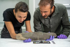
It was an instance of serendipity when, one day in late October, 2017, I happened to cross paths with William Kelso. We had no plans to meet, but I recognized him as I was snapping some photos of the most recent excavations within the vicinity of the old Memorial Church at the Jamestown Island, Virginia, archaeological site. Kelso is best known for his pioneering work discovering and uncovering the remains of the long-lost James Fort, thought for decades, until 1994, to have vanished into the water of the James River long ago as the river eroded its way into the island over the centuries. That discovery, and the hundreds of thousands of artifacts that have since come to light about America’s first permanent English colony, have arguably for many defined one of the great archaeological discovery stories of the past century.
We spoke only briefly, but it was enough to generate the distinct impression that Kelso, currently Head Archaeologist for the Jamestown Rediscovery Project and veteran of decades of research, had no plans to retire soon. His legacy, however, has already been made. Standing to witness were the manifestations of evidence for America’s first permanent English colony surrounding us as we talked, from sections of the reconstructed post-in-ground palisade walls of the original 1607 James Fort to the partial reconstruction overlying the footprint of the first-ever church structure built at the site, where Pocahontas and John Rolfe exchanged their marriage vows in 1614. This is aside from the more than two million total artifact haul accumulated since Kelso’s excavations at the site began, most of which is unseen by the public eye but some of which, over 4,000 strong, can be seen in the Archaerium museum only steps away from where we stood to talk.
For most people it would be enough to walk about the site. It is certainly impressive enough. But for other members of the public, like me, curiosity can only be sufficiently quenched by thoroughly reading about the details of the groundbreaking (pun intended) discoveries that have been made here over the past 20+ years. Kelso has made this possible with the publication of his most recent book, Jamestown,The Truth Revealed.
Kelso qualifies by making no secret of the fact that fully 60 percent of the book constitutes a re-publication of his previous book, The Buried Truth, to provide a fuller context or precursor to the discoveries made in more recent years, equally compellingly documented in the book’s second part, “More Buried Truth”.
It is the book’s second part, and more, that is the focus here. I relate it by way of the chapter headings assigned within the book itself:
Holy Ground
As the title of Part II’s first chapter suggests, excavation work at the site has uncovered some tantalizing evidence of the central role the English, or Anglican, Church played in the culture of Jamestown’s first colonists. Wasting little time after their arrival in 1607, the colonists, under the direction of its leadership, constructed one of America’s first English ecclesiastical buildings — a simple post-in-ground structure that saw several renovations or revisions in very short order. William Strachey, writer and Secretary of the Colony in 1610, wrote this first-hand account of the structure, in which Pocahontas and John Rolfe were famously married in 1614. It describes the church as it appeared during his tenure:
In the middest [of the fort]…is a pretty chapel…It is in length threescore foot, in breadth twenty-four…a chancel in it of cedar and a communion table of black walnut, and all the pews of cedar, with fair broad windows to shut and open…and the same wood, a pulpit of the same, with a front hewn hollow, like a canoe, with two bells at the west end. (1)
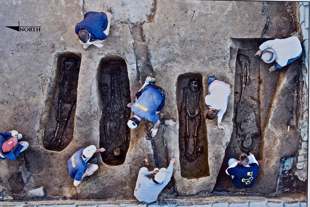
It was Strachey’s account of the structure, clues from other sources, and excavations in the southeastern sector of the James Fort that turned up the tell-tale signs of the building, revealing deep post-holes all in alignment very close to the dimensions Strachey described, and four burials located in what would be the chancel area of the church.
Although the traces of the church structure was big news when archaeologists first revealed the remaining soil stains left by the structure’s long-decayed post architecture, it was the burial discoveries that eventually commanded the most attention from the press and public. That is because, consistent with the long-held burial practice of English society at that time, high-status individuals were found to be buried beneath church chancels — and, in this case, it would be individuals who had played essential leadership roles in the founding and settlement development of Jamestown in its very earliest years. Forensic analysis of the skeletal remains, other archaeological evidence, chemical analysis, and historical documents confirmed with a confident degree of certainty that the individuals buried within the chancel space were likely Reverend Robert Hunt, Sir Ferdinando Wenman, Captain Gabriel Archer, and Captain William West, all known “movers and shakers” of the Jamestown settlement. Kelso, without getting the reader lost in what could have been a mind-numbing technical report, nonetheless goes into meticulous and satisfying detail about the discoveries in the text of the chapter.
Identifying the big names was sensational, without question. But how did the early church finds add to what we already knew about the first years of the Jamestown settlement?
Kelso emphasizes at least several major takeaways. First, that “the biographies of four practically anonymous Jamestown leaders have come to life,” and that “Wenman and West, both relatives of De La Warre [the Jamestown leader best known for having commanded the supply fleet that arrived in Jamestown in June 1610 after the ‘starving time’, in time to save the colony from a final collapse], were held in high esteem at Jamestown.” Second, it suggested how the established system of English hierarchy was transported to the New World, with the Anglican Church as the “center of the James Fort’s society, spiritual and secular.” And third, the excavation results confirmed that the first, 1608 – 1616 church structure stood apart and separate, although only yards away, from the later church built upon a brick-on-cobble foundation, the one initially built in 1617 and in which America’s first democratic assembly met in 1619. The church where Pocahontas was married was not the same church in which the seeds of the U.S. American government were planted. (2)
_______________________________________
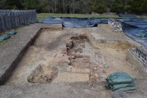
Aerial view of the excavated features of the 1608 church. Photographed detail of an informational placard at the Jamestown historic site. Jamestown Rediscovery project, Preservation Virginia
______________________________________________________
Excavated burials in the 1608 church chancel area. Photographed detail of an informational placard at the Jamestown historic site. Jamestown Rediscovery project, Preservation Virginia
____________________________________________________
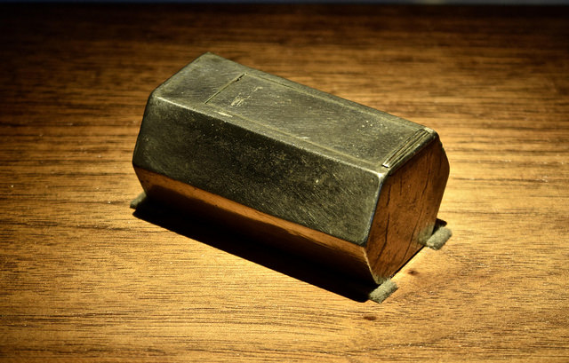
Above: Archaeologists unearthed a small silver box, placed at the time of his burial on top of Gabriel Archer’s coffin. Micro CT scanning analysis revealed it to be a reliquary, which is a container for holy relics. Although corrosion has precluded analysts from opening the box, scanning revealed that it contained fragments of bone, likely human, and fragments of a lead ampulla. Ampullae were small flasks used to carry blood, holy water, or oil. Why it was placed on Gabriel Archer’s coffin remains a mystery.
____________________________________________________
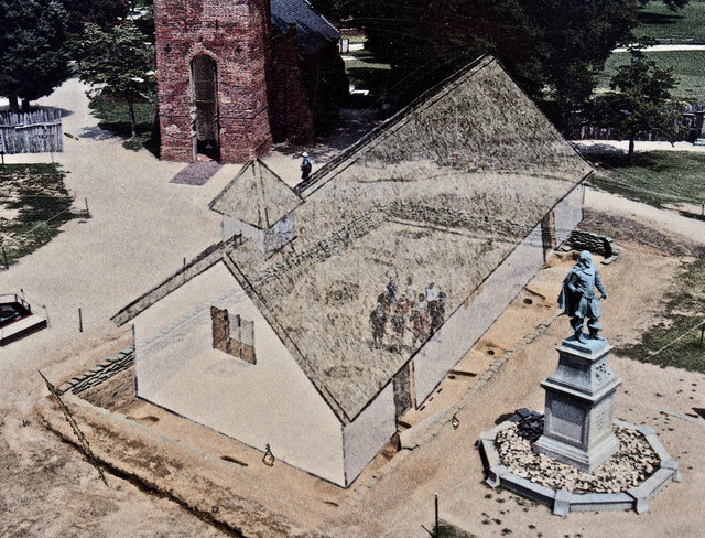
Artist’s illustration depicting the form and dimensions of the 1608 church as it would have appeared in its day. Photographed detail of an informational placard at the Jamestown historic site. Jamestown Rediscovery project, Preservation Virginia
_______________________________________
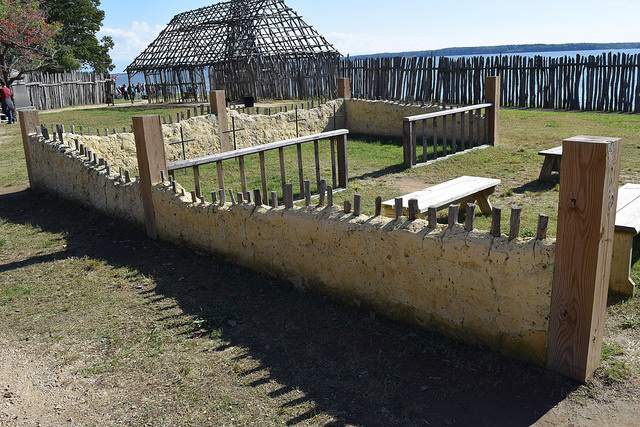
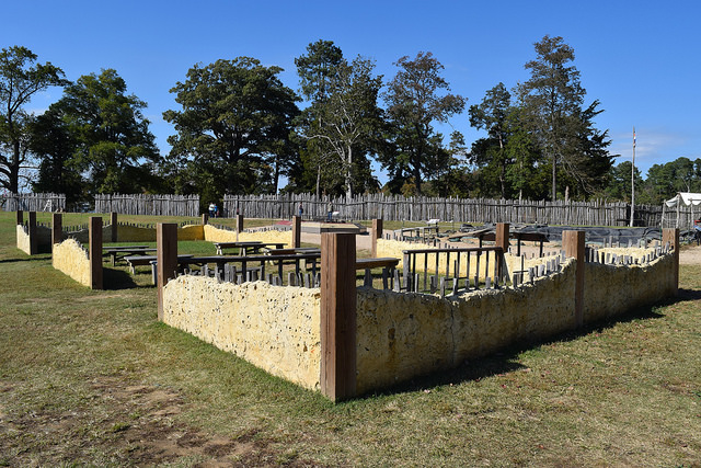
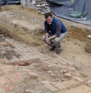
Above and below: Views of the partially reconstructed 1608 church, after excavations.
____________________________________________________
_____________________________________
Jane
Although Jamestown’s claim to fame has rested primarily on its mantle as America’s first successful English colony, a darker side to its story tells how close the fledgling colony came to failure. That close call, as most people who have followed the Jamestown story know, was due most acutely to the horrendous period of starvation the colonists faced during the winter of 1609 – 1610. Brought on by a combination of concurrent factors, such as crumbling relations with the local Powhatan resulting in hostility and siege of James Fort, a drought, and dwindling food supplies and sources, it became known to history as the “starving time”. The written record has recounted this episode with some startling narrative:
Wee cannot for this our scarsitie blame our Comanders here, in respect that our sustenance was to come from England…soe lamentable was our scarsitie that we were constrayned to eat Doggs, Catts, rats, Snakes, Toadstooles, horse hides and wt nott, one man out of the mystery that he endured, killinge his wiefe powdered her app to eate her, for wch he was burned. Many besides fedd on the Corps of dead men…and one who had gotten unsatiable, out of custome to that foode could not be restrayned, untill such tyme as he was executed for it.(3)
The historical narrative is powerful and excruciatingly detailed, but generations of scholars and the public had to rely on the truthfulness and accuracy of the written word for these events — the physical evidence was absent. Until, that is, Kelso and his team began uncovering artifacts and bones that indicated something terrible was happening at Jamestown during this period. Excavations yielded burials, bones, artifacts and contexts that, after analysis, provided plausible evidence that the “starving time” did indeed occur and was likely as horrific and severe as documented. The one discovery that captured the imagination of scholars and the public alike, however, was the recovery of the remains of a 14-year old girl. Kelso relates the details of this story in the chapter, Jane. Reading almost like a detective mystery, Kelso does not scrimp on the thorough telling of how the researchers, through archaeological and forensic anthropological analysis, determined that the skeletal remains, consisting of more than a dozen specimens including a female human skull, jaw with teeth, and shin bone — all found with discarded “starving time” trash in a cellar/kitchen fill — had been butchered in an act of cannibalism. Doug Owsley, the Smithsonian Institution’s renowned forensic anthropologist and a consultant to the Jamestown excavations, was key to making the determination:
Owsley determined that the skull and leg bone had undergone sustained blows, chops, and cuts from several sharp, metal implements, reflecting a concerted effort to separate the brain and soft tissue from bone. Months of intensive scientific testing — including high-magnification technology, stable isotopic tests for oxygen, carbon, and nitrogen, and tests for lead — determined that the bones were the remains of a fourteen-year-old English girl of lower status, probably raised in southern England. Owsley concluded that the rigorous postmortem cuts to the skull and jaw, and the way the leg was severed, were clear evidence of cannibalism.(4)
Researchers have been unable to pinpoint the girl among the roster of settlers, and thus she remains unidentified. She is known simply by the name, for lack of any other, assigned to her: “Jane”.
Researchers have since created a believably lifelike and, by professional standards, accurate forensic sculptural reconstruction of Jane’s face and skull using a digital resin copy of her skull based on the skeletal finds. In addition to reading about the Jane story in Kelso’s book, it is well worth the visit to the Archaerium museum at the Jamestown site to view the reconstruction.
___________________________________
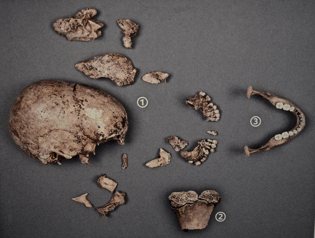
The cannibalized remains of Jane, all constituting parts of the (1) skull; (2) shin bone; and (3) jaw. Photographed from a public display illustration in the Archaerium.
______________________________________________
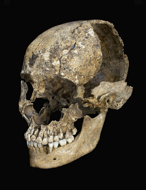
Jane’s skull. Smithsonian image
_________________________________
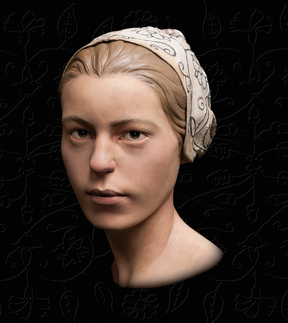
Forensic sculpture reconstruction of Jane’s face. Studio EIS
____________________________________
Company Town
Archaeologists get very excited about finding middens (old refuse dumps) and wells. There is good reason for that. Like treasure chests for archaeologists, they often contain the greatest concentration of the bits and pieces of past civilizations. This has been particularly true for Jamestown. In the book’s final chapter Kelso covers a lot of ground, but his discussion of what Jamestown excavators have recovered from the historic James Fort wells dominates the narrative. And rightly so. The wells, particularly the two described in “Company Town”, have yielded some of Jamestown’s most intriguing artifacts. Although thousands of artifacts were recovered, one of the wells, associated with an excavated storehouse and its cellar, constructed inside the James Fort palisade triangle, gave up two objects worth noting here: A 5” by 8” slate tablet featuring inscriptions of words, symbols, numbers, and drawings of people, animals and plants; and fragments of 8 curiously marked Robert Cotton* clay tobacco pipes. The slate tablet discovery, which Kelso described as “not unlike finding the proverbial lost letters in an attic trunk,” had the distinction of being “both an archaeological find and a historical document.”(5) But accurately reading and interpreting the inscriptions on its face have been challenging, to say the least. Nonetheless, Kelso devotes fully 8 pages to describing the inscriptions, the efforts to understand them, and what they mean in terms of understanding what was happening at Jamestown. A close second in terms of the chapter content is the 7-page description of the pipe finds. These pipe fragments were interpreted to bear the names of 8 well-known English gentlemen: Sir Walter Raleigh, Lord De La Warre, Captain Samuel Argall, Sir Charles Howard, Henry Wriothesley, (the Earl of Southampton), Captain Francis Nelson, Sir Walter Cope, and Robert Cecil (Lord Salisbury) — all gentlemen associated with the Jamestown venture in different ways. “Why Cotton had to name them remains one of the most intriguing mysteries of the abandoned cellar/well finds,” Kelso writes. “Like the writing slate, however, the names on the pipes are examples of some of the surprisingly literal messages left to us by Jamestown’s past.”(6)
The second of the two wells, described by Strachey as intended to replace the old storehouse/cellar well, was discovered about 80 feet further north of the old well, but still within the James Fort palisade triangle. Its story is as much about its original construction as the artifacts found within. As the archaeologists excavated, they discovered that “at a depth of eight feet, six inches, the soil became moist, and remnants of timber lining appeared. Digging below that revealed more and more intact remnants of the lining until the timber was completely preserved to the bottom, fourteen feet below grade.”(7) The latter part of the excavation had to be conducted in water — a difficult situation — but in addition to the timber, the conditions produced by the water in the bottom portion of the well helped to preserve some other tantalizing finds, such as the remains of a child’s leather shoe and what is thought to have been Lord De La Warre’s ceremonial halberd, intact and remarkably preserved. An elegant loaded pistol, of a type that was likely considered state-of-the-art for its day (apparently finding its way into the well between 1610 and 1617), was also found, as well as a lead “Yames Towne” shipping tag.
_______________________________________
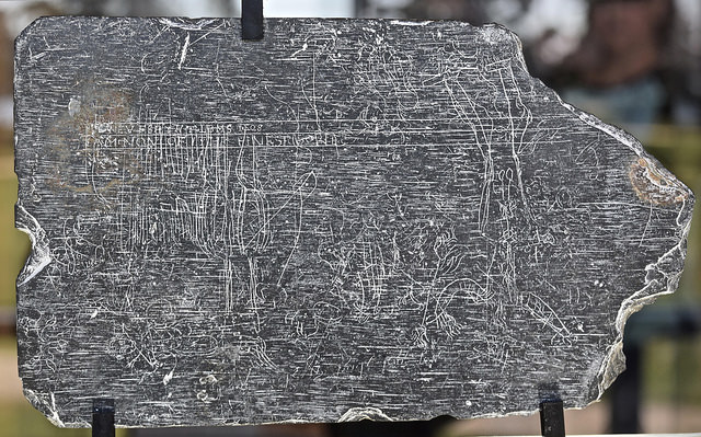
The slate tablet, as exhibited in the Archaerium
______________________________________
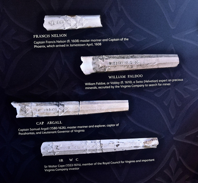
A selecion of the pipe stems, as exhibited in the Archaerium
___________________________________
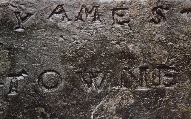
Detail of a lead Jamestown shipping tag, dated to 1611, found in the timber-lined well. As exhibited in the Archaerium
________________________________________
Holy Ground, Again
The book notwithstanding, it does not tell the end of the Jamestown excavations story. Indeed, the ink had barely dried with the book’s publication as excavations progressed full swing within the 1906 Memorial Church, today the most prominent architectural feature at the James Fort site. One of the excavation’s objectives, as with the first post-in-ground church dig to its northeast, is to uncover and hopefully identify who was buried in the church chancel — likely, as English tradition held in the early 17th century, burial remains of some of Jamestown’s most notable citizens.
Could the burials include Lord De La Warre, otherwise known as Thomas West, the leader who rescued the Jamestown colony from collapse with new supplies after the starving time, John Rolfe, the first successful tobacco planter and husband of Pocahontas, and George Yeardley, one of colonial Virginia’s early governors?
Intriguing new evidence unearthed within the chancel area of the church might possibly provide some clues. Archaeologists have already revealed evidence of burials, the presence of which were known from previous excavations conducted soon after the turn of the 20th century. Examination of recovered bones from the recent excavations by Smithsonian scientists in the lab are beginning to yield new information about who the bones represent, but nothing yet definitive in terms of identifying the buried. One set of bones, however, exhibited signs that the individual was robust, a man in his forties, and had tell-tale signs of having been a horseman. At least two out of the three findings thus far are consistent with what is known about Lord De La Warre.
It will take some time to ferret out the findings at the site and in the lab. For one thing, previous excavations and disturbances have vastly complicated the process. “We have not uncovered any more bones in place as of yet,” Kelso told Popular Archaeology. “We are still trying to sort out which graves came before which graves by the disturbed soil above the actual buried skeletal remains.”
One additional recent discovery is worth noting — a small metal box containing what has been detected by x-ray examination to be a piece of folded paper was unearthed in the northeast corner of the church foundation. A written note? “The paper is unreadable so far and probably never will be,” said Kelso. “Of course there is no doubt that the tin container was purposely buried [by the early excavators] under the north corner of the 1640s church during the 1901 digging.” The find exemplifies the many limitations and mysteries that may always remain about historic Jamestown, even through to the 20th century.
One thing should be emphasized — there is much more to the Memorial Church excavations than unearthing burials, (all of which, once recovered and researched, will be re-buried in accordance with the requirements of the Virginia Department of Historic Resources). The current structure, after all, lies above the foundation of the original 1617 structure, the church in which the first English governing representative assembly in America met. It was, among other things, the birthplace of the kind of government that eventually became the United States as we know it today and the center of the religious culture that helped to define a nation. Archaeologists are, at this writing, exploring the old foundations and recovering artifacts that will help to develop a deeper understanding of that historic site and its place in the American heritage.
_______________________________________
Excavation in progress within the Memorial Church
____________________________________________________
Interested readers may obtain a copy of Kelso’s latest book, Jamestown, The Truth Revealed, by going to the University of Virginia Press website. The book is, in this writer’s opinion, a must-read for those who want an in-depth, engaging, and easily understood source for the story of how archaeology is both affirming and revealing important beginnings of the American experience.
_____________________________________________________
Notes:
- Strachey, in Wright, Voyage to Virginia, 80.
- Kelso, William M., Jamestown: The Truth Revealed, 2017 University of Virginia Press, pp. 182 – 184.
- A True Declaration of the estate of the Colonie in Virginia, 1610, and The Tragical Relation of the Virginia Assembly, 1624, in Tracts and Other Papers, ed. Peter Force, 4 vols. (Washington, D.C., 1836 – 46), 3:16.
- Kelso, William M., Jamestown: The Truth Revealed, 2017 University of Virginia Press, p. 189.
- Kelso, William M., Jamestown: The Truth Revealed, 2017 University of Virginia Press, pp. 210 – 211.
- Kelso, William M., Jamestown: The Truth Revealed, 2017 University of Virginia Press, p. 226.
- Kelso, William M., Jamestown: The Truth Revealed, 2017 University of Virginia Press, p. 228.
*Robert Cotton was a pipe-maker sent to Jamestown as part of a re-supply in 1608, and is responsible for the making of a number of pipes found at the Jamestown excavations.
___________________________________________
1619: Archaeology and the Seeds of a Nation
July 30, 1619 — It must have been a very auspicious occasion for the newly established land-owning settlers when Governor George Yeardley stepped into the church for the very first meeting of the Virginia General Assembly at Jamestown. Months before, while still in England, he was appointed by the King to succeed Lord De La Warr who, to everyone’s surprise, had died at sea on a return voyage to the young but burgeoning Virginia colony. For extra measure, the King knighted Yeardley, had him provisioned to set sail, and ensured him detailed instructions from the Virginia Company to institute a comprehensive body of reforms. Those reforms would establish the rule of law based on English precedent in the home country, protect the individual rights and private property of the new Virginia landowners, and establish a General Assembly of representatives (consisting of his four councilors and 22 burgesses selected from the settlements along the James River) who would look out for the interests of the colonists.
For the untested frontier of Virginia and the New World, this was akin to a grand experiment in democracy, and deemed necessary to ensure the continuing development and prosperity of a fledgling colony that, just nine years before, was on the brink of collapse. By 1619, however, Jamestown had expanded well beyond its original Fort, even sporting well-appointed homes of gentlemen planters, surrounded by new plantations that defined the foundations of Virginia’s embryonic economic prowess as a tobacco-exporting powerhouse. Although Yeardley and his Virginia Company instructors were not fully aware at the time of the import of the first assembly, it was unique, constituting the seed of democracy in the Western Hemisphere.
It was appropriate that the first assembly convened in an early church structure built by the colonists. It was a comparatively spacious, single-room public structure, a 50-ft. by 20-ft. timber frame constructed over a brick and cobblestone foundation in 1617 when Deputy Governor Samuel Argall was still in control of the colony. This is small by today’s standards, but back then it was enough room for the first representatives to sit themselves comfortably into the “quire” (choir) space for six days during a hot summer.
The original church structure no longer exists. It was replaced over its remaining footprint by another church, this time constructed of brick beginning in 1639 and completed at the end of the 1640’s. Overall, the site has seen a succession of four different iterations, obscuring from sight all traces of the original timber frame structure of 1617, the building in which America’s first General Assembly convened.
Uncovering Lost Walls, and a Sensational Burial Find
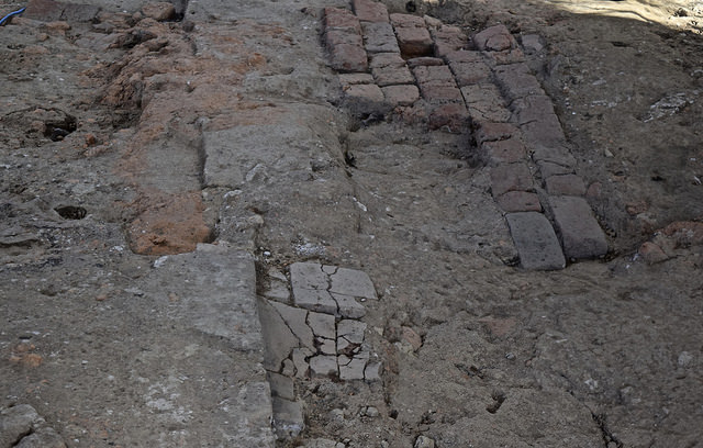
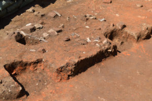
It wasn’t until archaeologists began excavating within the church (now the Memorial Church, built in 1907 at the same location) in November of 2016 that excavators eventually uncovered the evidence defining the complete original dimensions and foundational features of the 1617 church. This included, among other discoveries, remnants of a clay and cobblestone wall foundation while excavating the northeast corner of the chancel area of the church, and a narrow line of a brick-capped clay and cobblestone wall foundation running north-south through the center of a unit being excavated in the old church tower at the south end of the currently standing Memorial Church. Given the excavations and research conducted to this point, and the historical record of the original 1617 church at this location, archaeologists concluded that they had finally discovered the eastern and western wall foundations of the 1617 church. Material evidence of all four walls of the church in which America’s first representative assembly had met in 1619 had not been completely destroyed.
___________________________
The brick, mortar and cobblestone foundation of the south wall of the 1617 church exposed.
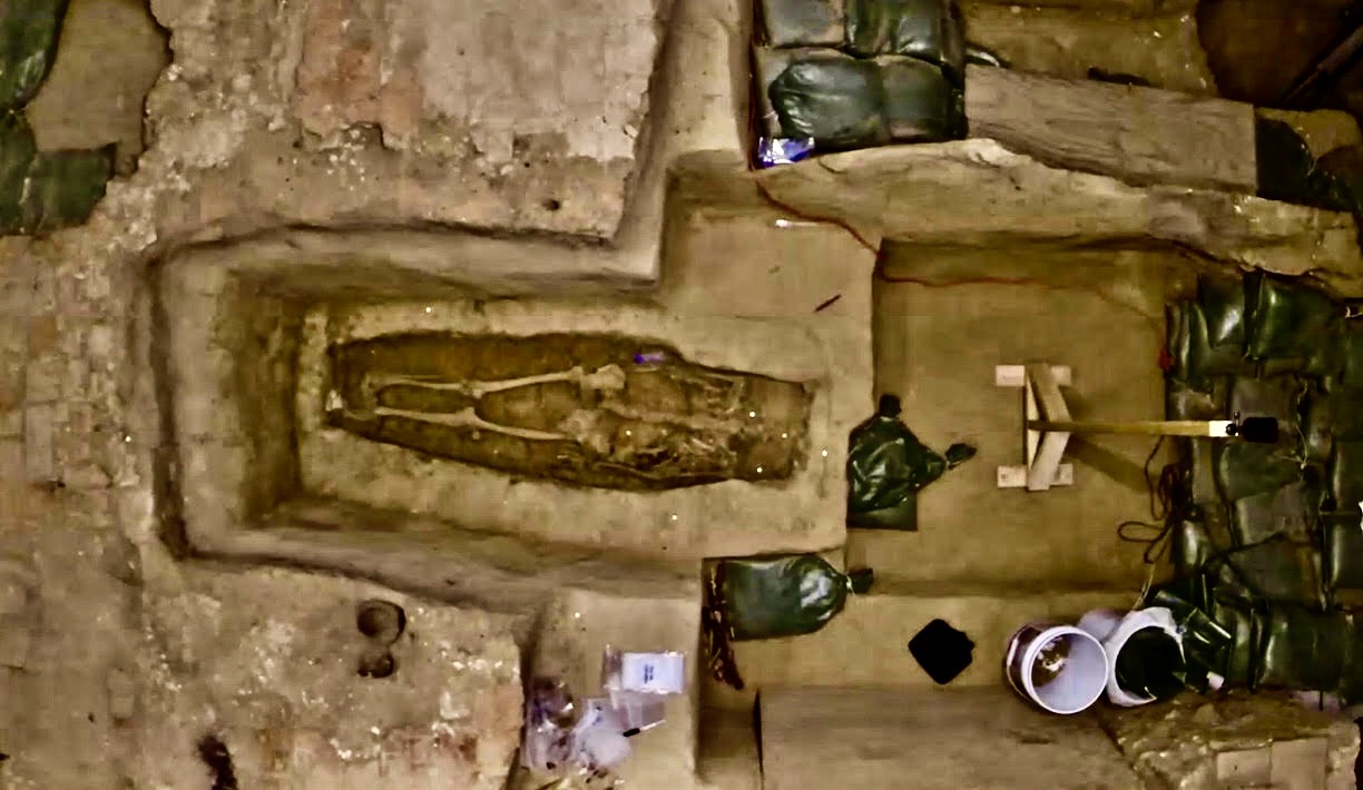
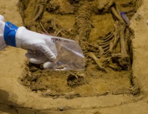
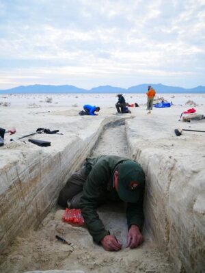
But perhaps the most sensational find emerged while archaeologists were excavating within the area of the church that once featured the central east-west running aisle of the 1617 church. Here, evidence of a relatively large grave shaft was uncovered. Soil stain and multiple nails indicated that a hexagonal-shaped coffin running east-west had decayed away in this place long ago. Its shape was similar in style to those uncovered a few years before in the excavated footprint of the earlier, 1608 church (where John Rolfe and Pocahontas were married) discovered only a few yards away. In that excavation, the remains of Reverend Robert Hunt, Sir Ferdinando Wenman, Captain Gabriel Archer, and Captain William West, all known “movers and shakers” of the Jamestown settlement, were identified. They had been buried in the chancel area of the church. And like those earlier burials, the burial in what would have been the aisle of the 1617 church would have been a prime location for a prominent individual. Then, before excavating any further, the use of high-frequency GPR and the resulting data indicated the presence of bones and the orientation of a skeleton within the grave — something that had never been done before through GPR applications.
The aisle burial excavation was executed quickly, from Friday, July 21st, through Sunday, July 23rd. This was necessary because they had arranged to have Doug Owsley, renowned forensic anthropologist with the Smithsonian Institution’s Skeletal Biology Program, and his crew, participate in the examination and exhumation of the bones on Monday the 24th.
But the skeletal remains uncovered in the grave shaft were missing one critical element — the cranium. This was essential to identifying sex, origin, and facial characteristics. The cranium also contains two bones that are key to acquiring DNA samples: the petrous temporal. Understanding the evolution of the church’s material history (burial disturbance being common in 17th century churches due to space limitations), the archaeological team searched for a cranium among the church excavation finds of the past year. As it happened, there were three crania candidates, one of which had already been found in articulation with other skeletal remains, and two others. By successfully matching disarticulated teeth uncovered in the aisle burial with one of the remaining two skulls, the archaeologists were able to identify the skull that originally belonged to the skeleton in the aisle burial. They now had a skull to complete the forensic analysis, along with genomic (DNA) analysis, important for a definitive identification of the remains.
Who was this individual?
David Givens, Director of Archaeology with the Jamestown Rediscovery Historic Jamestowne Project, and his colleagues suggest this might be the remains of Governor Sir George Yeardley himself.
What are the clues that back them up?
Givens and his team point to several things. First, the remains were found in a grave shaft located in the central aisle, near the chancel area of the 1617 church footprint — a burial location that would be reserved for a very prominent individual during that time. Second, forensic analysis of the skeletal remains revealed that this individual was male, around 40 years old, was accustomed to light work (not heavy work as would be typical for a common laborer), likely spent considerable time on horseback and/or wearing armor, and consumed foodstuffs indigenous to this New World area, indicating considerable time spent in the New World. These characteristics would have been consistent with the historical profile of George Yeardley. Thirdly, a 32″ by 68″ distinctive Belgian black limestone tombstone (dubbed the “Knight’s Tombstone”, discovered years earlier at what would have been the southern entrance to the later 1640’s brick church that was constructed over the same site ), now thought to have been originally located where the center aisle burial of the 1617 church was discovered, features engraved depressions depicting a gentleman in armor typically for that of a knight. As noted earlier, Yeardley was knighted before he left England again for the Americas. But Yeardley was one of two knights who died during the time period of the second church (c.1617 to c.1639), the other being Lord Delaware, or Sir Thomas West, the colony’s first governor. Nonetheless, researchers suggest that the tombstone was likely Yeardley’s, as the will of his step-grandson, Adam Thorowgood II, notes a request that his tombstone be engraved similarly to that depicted on the Knight’s Tombstone.
__________________________
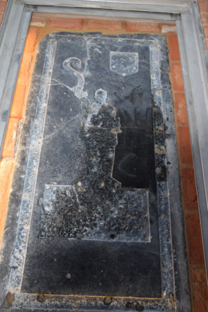
The Knight’s Tombstone
__________________________
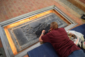
The Knight’s Tombstone undergoing tedious restoration.
__________________________
None of this, however, would prove to be definitive evidence attesting to the identification of the remains of George Yeardley without corroborating results from genomic, or DNA, testing. To this end, Givens and his team began collaborating with Dr. Turi King of the University of Leicester, the geneticist who previously directed genomic research to identify the remains of King Richard III in 2013. Teamed with experts from the FBI’s DNA Support Unit (DSU) laboratory, King and colleagues were able to extract enough DNA material from the remains to achieve a 75% recovery rate, which led to building a full DN sequence on the individual. While research and analysis continues, researchers suggest the possibility that the results could yield information about the individual as detailed as hair and eye color. But while the genomic research under her direction has progressed satisfactorily, the genealogical search needed to find the right living relative for the comparative DNA analysis has thus far proven to be a “sticky wicket”, as Givens phrased it. This is in part due to the fact that Yeardley’s mother was adopted, so tracing the lineage forward from her using mitochondrial DNA (a proven method long used by geneticists for such endeavors) would lead them nowhere. But tracing through his natural grandmother (mitochondrial), or his father or grandfather through Y-chromosome analysis could produce results once the right living relative could be identified through genealogical research. Enter here University of Leicester’s Kevin Schürer who, like King, was involved in the investigations to identify the remains of King Richard III. Brought in by Given’s team for his expertise in genealogical research, Schürer is endeavoring to test the recovered DNA against DNA from at least one relative in the direct line of descent from Yeardley. Thus far, Schürer has identified 26 female lines of descent four generations deep, and work continues.
Meanwhile, forensic analysis of the bones continued to reveal new results. Owsley and his Smithsonian team have been busy developing a full forensic profile of the remains, which will tell us more about the life that belonged to the bones before death. Moreover, Dr. Peter Quinn and Dr. Greg Maslow of the University of Pennsylvania, along with others from Penn Medical, the Penn Museum and Penn Dental, have examined the remains, resulting in observations that could reveal new facts that, if the bones prove definitively to be those of Yeardley, will tell us personal medical details untold by historical documents. According to these researchers, this man suffered from a crippling ailment: osteomyelitis—a severe and painfully worsening bone infection that paints a profile of a person in declining health at the end of his life.
__________________________
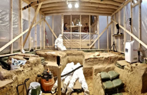
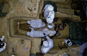
Panoramic view of the aisle burial excavation area. A sealed structure was built over the excavation area to reduce DNA contamination. The “tent” was positively charged with filtered air conditioning and all tools and equipment were sterilized prior to the dig. Excavators were donned in special suits for the same purpose. Courtesy Jamestown Rediscovery
__________________________
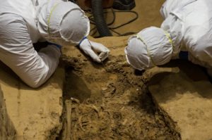
Director of Archaeology David Givens and Senior Staff Archaeologist Mary Anna Hartley carefully excavate maxillary incisors adhered to the first cervical vertebra of the skeleton.Using fine tools and techniques, excavating the delicate remains was a slow and meticulous process. Courtesy Jamestown Rediscovery
__________________________
A tooth recovered from the individual (adhered to the first cervical vertebra). Teeth are critical for DNA analysis. Courtesy Jamestown Rediscovery
__________________________
Overhead view of excavators hard at work on the skeletal remains. Courtesy Jamestown Rediscovery
__________________________
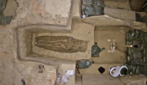
Overhead view of the completely excavated skeletal remains. Notice the missing skull. Courtesy Jamestown Rediscovery
__________________________
Yeardley, Slavery, and More Burials
While Yeardley played a key role in establishing the first seeds of freedom and democratic governance in the New World, some irony or incongruity is not lost on the fact that he was also among the first ‘slaveholders’ in America. Ships arrived at Point Comfort (on the coast of present-day Virginia) in 1619, the very same year of the First General Assembly, unloading a human cargo of Africans for sale to early English planters who transported them to the newly founded English colony and its surrounding developing plantations (see the article, Digging the Roots of American Slavery). Yeardley, also a prominent Virginia planter, likely became the recipient of some of these new servants.
But were these first Africans actually slaves or something more akin to indentured servants who, after a period of time, were permitted to acquire their freedom and live independent lives? The probability is high that this may have been their status, as slavery as it was codified into law in the colonies decades later did not exist at that time in the form most familiar to American history. The first Africans’ experience nonetheless arguably laid the foundation upon which the institution of slavery was born and flourished through the subsequent decades. Thus began the story of the great American paradox, a reality that has haunted American society since its inception.
Beginning in 2017, Givens and his team began excavating an area within easy walking distance east of the original James Fort location in Jamestown. Historically, it is thought to contain evidence for the property of Captain William Pierce, among those of other wealthy planters. Like his peers, Pierce was an influential planter and merchant who built an impressive house within the newly developed town east of the James Fort area (known as New Towne) in the wealthy section known as ‘Back Street’. He was also the owner of a servant known from a 1624 muster (census) that recorded the presence of 21 Africans. One of them, a female African servant referred to as ‘Angela”, was documented as being connected to the Pierce household. Based on other historical documents, Angela is presumed to have been among the first group of Africans to arrive in Jamestown in 1619. The excavation has thus acquired the nick-name as the “Angela site”, and has been a focus of Givens’ research and investigations to define the greater James City that sprawled east of the original James Fort location. He has been working in collaboration with the National Park Service to this end.
What have they uncovered?
“A lot of people think we’re looking for Angela,” said Givens. “But that’s not what we’re doing. We’re looking at the contextual — the world in which Pierce was an actor [and by extension Angela].” And that context is slowly coming to light. Artifacts and other structural evidence of early 17th century occupation has emerged. Evidence of early 17th century posts have been uncovered at the site. Archaeologists interpret the finds as features of a gable end or addition to a house structure. But archaeology is a slow, painstakingly deliberate process, and the footprint of Jamestown in this area is exceedingly complex, given the continuous building, construction destruction and re-building, and turnover of occupants in succeeding generations of early Virginians who made their lives here. Moreover, the application of remote sensing techniques, such as LiDAR, is beginning to present some surprises, causing archaeologists to question the precise location of some town elements, such as the colonial road and other town structures that may potentially be found, possibly shifting the long-standing interpretation of the James City landscape.
GPR applications have also revealed another head-scratching development. Several burials were discovered. But these burials did not fit the pattern seen elsewhere at Jamestown — disparate, scattered in a corner lot, they defied the placement normally observed with families, lineages, or other groups on the historical landscape of Jamestown. Givens knew they had to be early burials, as no materials datable to later time periods were present at the burial locations.
This was something the archaeologists had not previously encountered. “We can’t ignore the fact that, spatially, we’re seeing something new and unique,” says Givens.
Popular Archaeology asked Givens if he had any thoughts about who these people may have been. “Indentured servants, perhaps,” he said. This could explain the nature of the burials.
Could they be some of the first Africans? It would be difficult to know without actually excavating the burials, and that would likely not happen soon, if at all, as permissions and approvals must be obtained before initiating any excavation of skeletal remains discovered in a grave site.
For now, they remain points on a newly emerging archaeological landscape.
_________________________
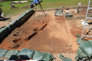
Above and below: Features emerging in the excavations at the ‘Angela site’ as of late April, 2019.
_________________________
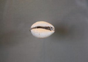
Cowrie shells had monetary and spiritual value to enslaved Africans during the 17th and 18th century in the British colonies. This cowrie shell was excavated at the ‘Angela site’ at Jamestown.
_________________________
Digging the Roots of American Slavery
April, 2018 — For early April, archaeologists couldn’t ask for better weather. A gentle breeze, low humidity and comfortably cool shirt-sleeve temperatures were ideal for wielding a trowel and shovel. As I walked with camera in hand along a path through a grassy flat of land that was once graced with early 17th century structures, I spied a small team of archaeologists swarming about a single excavation unit — a shallow hole in the ground, squared off with near-perfect vertical walls defining its perimeter. They were digging up, with carefully managed precision, an old excavation unit completed in part in the 1930’s by a previous excavation team. They were going over old ground, but with new techniques and new objectives, digging deeper into a stratigraphy that began to yield artifacts — including early 17th century objects — not reached and recovered by the old excavation. Towering above them just a few yards away were the imposing ruins of the 18th century plantation mansion of Richard Ambler, one of Jamestown’s prominent and wealthiest citizens. I couldn’t resist snapping a few photos of this old house. It commanded the view of the landscape, drowning out, with its great architectural shout, everything else on the surface within its vicinity. But a far more compelling story was beginning to emerge as these archaeologists dug beneath the grassy yard in which the old ruin stood. It was far less noticeable to the visitor’s eye — but much more intriguing……….
_____________________________________
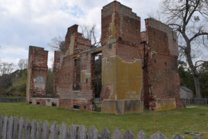
Ruins of the Ambler Mansion, built about 1750.
______________________________________
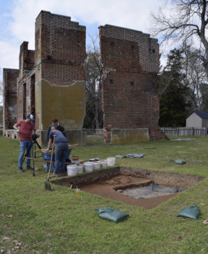
Archaeologists at work on the lone excavation unit near the foot of the Ambler Mansion.
______________________________
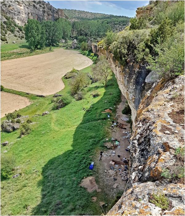
The Back Street Boys
Leading the dig project was David Givens, a senior archaeologist with the Jamestown Rediscovery Historic Jamestowne project, under the auspices of the Association for the Preservation of Virginia Antiquities (or APVA/Preservation Virginia). The excavations at Jamestown have been best known in recent decades for the discovery of remains connected to the original 1607 James Fort under William Kelso, which have thus far yielded hundreds of thousands of artifacts and archaeological features that define the very first ‘footprint’ for successful permanent English settlement in the Americas. Excavations at the site of the Fort are ongoing. But beginning in 2017, Givens and his team began excavating an area within easy walking distance east of the original fort location. It contained evidence of occupation known historically as the property of Captain William Pierce*, a wealthy and influential planter and merchant who built an impressive house within the newly developed town east of the James Fort area (known as New Towne) in the wealthy section known as ‘Back Street’. His home was described as “one of the fairest in Virginia”, set in a neighborhood that housed the likes of the city’s most prominent and wealthiest citizens, such as Dr. John Pott, Governor Sir Francis Wyatt and Governor John Harvey. Future years saw the construction of even finer brick homes in this section by society notables like Richard Kemp, William Sherwood, Henry Hartwell and William May. It was here, also, where the before-mentioned planter Richard Ambler built his mansion in the 1750’s, the ruins of which still visibly mark the landscape today.
For its time, Back Street represented some of the finest physical fruits of colonial America’s richly bequeathed and successfully enterprising gentlemen visionaries, planters and merchants. But their high level of 17th century upscale living involved, among other things, the employment of labor through the servitude of others to do the work that the landed gentry would not do to support their privileged lifestyles. In early 17th century America, this meant the importation of human servants. Among them were the first Africans to land on American English colonial soil — the embryo of what would become slavery — and the households along New Towne’s illustrious Back Street were the first to take in African servants. For Givens and his team, the archaeology of the William Pierce property thus presented a unique opportunity to reveal the material and cultural context in which the first Africans, and thus the rudiments of the beginning of slavery, emerged. A mandate supported by initial funding from the National Park Service under a civil rights initiative grant during the Obama Administration made this possible.
_______________________________
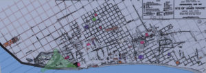
The “Cotter”map showing some of the previous archaeology done in New Towne, the 17th- century town that grew up east of James Fort. The grid system used 100′ blocks with trenching every 50′. Larger open areas were excavated around some sites and buildings. Archaeological excavations were last conducted in New Towne in the 1990’s. Archaeologists today are using the same grid system to tie in their excavations with the previous work. Image and text photographed from a plaque display near the site of excavations at the Pierce property site.
______________________________
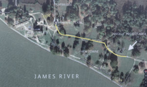
The project area is on the Pierce property in New Towne, located just past the 18th-century Ambler mansion ruins, about 325 yards east of the tercentary obelisk monument. Image and text photographed from an informational plaque near the Pierce property excavation site.
______________________________

The targeted Pierce property excavation area near the Ambler Mansion. Courtesy David Givens and the Jamestown Rediscovery Historic Jamestown Project, Preservation of Virginia Antiquities
_________________________________
Angela and the Beginnings of Slavery
Written history has not been generous to posterity about revealing the lives of English colonial America’s first Africans. But in early 17th century Jamestown, a 1624 muster (census) indicated the presence of 21 Africans. One of them, a female African servant referred to as ‘Angela”, was connected to the household of Captain William Pierce. Based on other historical documents, Angela is presumed to have been among the first group of Africans to arrive in Jamestown in 1619.
Interestingly enough, the historical context of her journey and arrival in America was actually defined by the intersection of the early 17th century world slave trade and high seas piracy.
Between 1618 and 1619, the Portuguese nobleman and colonial Governor Luis Mendes de Vasconçelos of Angola (in West Central Africa) led a series of campaigns that resulted in the capture of thousands of Kimbundu-speaking people —men, women and children — to populate six slave ships bound for Mexico. Well before the slave trade began to have any impact on the fledgling English colonies in America, the Spanish and Portuguese were funneling new slave power into the developing colonial economies of their realms in the New World — in this case, the rising economy of Vera Cruz in New Spain (present-day Mexico). Little did Vasconcelos know, however, that some of his cargo would ultimately end up at Jamestown, via pirating by the English in 1619. The ship São João Bautista, carrying about 350 enslaved Africans after departure from the port of São Paulo de Loanda, a Portuguese military outpost in West Africa, found itself about 50 slaves lighter after being intercepted by the White Lion and the Treasurer off the coast of Campeche (in present-day Mexico), both ships having sailed out of the Netherlands. The ships arrived at Point Comfort (on the coast of present-day Virginia) in 1619, unloading their human cargo for sale to early English planters who transported them to the newly founded English colony and its surrounding developing plantations. Angela was likely among them.
Were these first Africans, including Angela, actually slaves or something more akin to indentured servants who, after a period of time, were permitted to acquire their freedom and live independent lives? The probability is high that this may have been their status, as slavery as it was codified into law in the colonies decades later did not exist at that time in the form most familiar to American history. But these first Africans nonetheless arguably laid the foundation upon which the institution of slavery was born and flourished through the subsequent decades.
The Excavations
Contrary to what the popular perception might be about the newly opened dig, these excavators are not looking for the human remains of slaves.
“A lot of people think we’re looking for Angela,” said Givens. “But that’s not what we’re doing. We’re looking at the contextual — the world in which Pierce was an actor [and by extension Angela].”
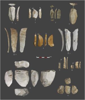
It will be a long and tedious task. “There are 243 years of slavery under your feet,” Givens told me as we stood together next to the excavation unit as the archaeologists worked. “Here, folks came and went in fairly quick succession in the 17th century. And Pierce’s property was extensive, including two storehouses and planting areas.” It was located in a city, so this is “like searching for a needle in a stack of needles.” Givens showed me a selected sampling of artifacts unearthed from the unit. This assemblage included fragments of ceramic ware produced by a Jamestown potter during the 1st quarter of the 17th century. They were taken from three bulging paper bags of objects excavated only within the last week and a half from the single unit.
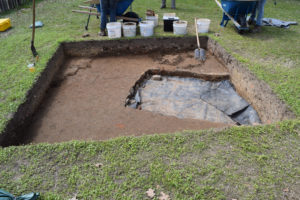
Givens leads me to a much larger excavated area only steps away from the smaller unit. He points out some exposed features at the location of the early 17th century Pierce residency. We were looking at what he described as possibly a “half cellar” space, tentatively and roughly dated, based on the finds within the cellar and its context, to no later than the 1630’s. Excavations have continued since my visit to the site. Since then, says Givens, “we are now finding artifacts that date prior to 1625. We are very near a component of the Pierce holdings”.
______________________________
A view of the excavation unit near the Ambler Mansion as it appeared in early April, 2018.
_______________________________
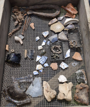
A small sampling of the assortment of artifacts unearthed from the excavation unit during a single week and a half of work at the site.
__________________________________
A view of the main excavation site at the location of the Pierce property as it appeared in early April, 2018.
________________________________
David Givens examines some recently excavated features at the site.
______________________________
This excavation is only in its beginning stages. There is a long way to go. The project could require, in Givens’ estimation, at least 10 years, “if not a career” to bring everything to a conclusion. More funding will be sought. The biggest takeaway will revolve around helping to elucidate the world in which Angela and her other First African contemporaries lived, and, if the archaeologists and historians are so fortunate, even add to our knowledge of specifically how Angela lived, what she ate, how she may have been treated, and what she may have seen or witnessed about early 17th century Jamestown.
“We will find the empirical evidence and test it against the historical record — a record that was produced primarily by rich, white, educated males,” said Givens. But, he added, “I think the archaeology and history is showing (at this early stage) how diverse the emerging colonial landscape was. Our modern notions of race and how folks negotiated their lives has been generalized (and perhaps white-washed) over the centuries. At Jamestown, archaeology can play a key role in reorienting our understanding of how First Africans impacted the material record of a very complex world of colonial entanglement. By unpacking this history, we are addressing the integral role individuals, like Angela, played in the growth of our Nation and how we view that past.”
Popular Archaeology will be covering new developments in the future as they emerge from the excavations.
Stay tuned.
_______________________________
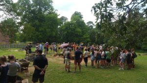
Members of the public visiting the excavation site. One of the reasons for selecting the site for excavation was because of its visibility and accessibility to the public. Courtesy David Givens and the Jamestown Rediscovery Historic Jamestown Project, Preservation of Virginia Antiquities
_______________________________
Read more about the exciting archaeological work and latest discoveries on Virginia’s Jamestown Island by visiting this site.
Did you like this article? See George Washington’s Forgotten Slaves, published in a previous issue.
__________________
*”A wealthy, influential planter and merchant who had arrived in Virginia in 1610, Peirce also owned a store in Jamestown. A “beloved friend” of Governor Francis Wyatt, Captain Peirce was the colony’s cape merchant and also served as lieutenant governor and commander of Jamestown Island. He was responsible for the island’s two blockhouses and appointed captain of the governor’s guard.” https://www.findagrave.com/memorial/103843198/william-pierce
__________________
Advertisement
__________________


.jpg)