
Editor’s Note: The following updates a previously published article, presenting information based on new fossil research.
For most people, the Turkana Basin in northwestern Kenya is a fiercely inhospitable place. It is hot and dry — an arid, desert-like scrubland. At its center lies Lake Turkana, an enormous, expansive, alkaline body of water that has gained the apt description as the world’s largest permanent desert lake. There are no major resorts along its shores. Though rich as a source of fishing for the local economy, it’s flats team with Nile crocodiles and its shores are abundant with scorpions and carpet vipers. But this lake lies front-and-center within a region the geology of which has yielded one of the world’s great treasure-house landscapes of exposed beds teaming with fossils extending as far back as the Cretaceous period. The unforgiving environment was thus no barrier to the teams of paleontologists, geologists and paleoanthropologists that found their way here over the decades to explore and survey the landscape. And it was along the dried up Nariokotome river bed not far from the lake when, in 1984, eagle-eyed goat herder and fossil hunter, Kamoya Kimeu, spied a peculiar skull fragment. Kamoya honed his skills and reputation over the years in the employ of the renowned fossil hunting paleoanthropologist team of Mary and Richard Leakey. Kimeu knew what he was doing.
In time, through survey and careful excavation, the skull fragment turned out to be just one of 107 other bones, all members of the skeletal remains of a single individual animal….
A hominin.
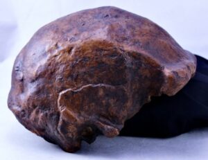
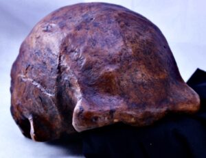
Turkana Boy
The remains represented an almost complete skeleton. Once pieced together, it revealed what for its time was a startling new hominin discovery. The cranium was small, indicating a brain that was only two thirds the capacity of modern humans. The interior of the cranium featured asymmetry of a longer left brain over the right, suggesting the possible beginnings of the physiological capacity for speech.
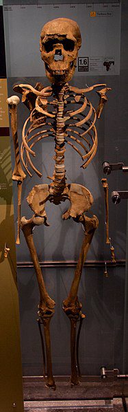
Full Turkana Boy skeleton, as exhibited at the American Museum of Natural History, New York. Mike Peel , CC BY-SA 4.0, Wikimedia Commons
The post-cranial skeletal features featured shoulders, arms, torso with a barrel-shaped chest, a tucked-in pelvis, and legs that more closely resembled those of modern humans, as opposed to modern apes, though the feet were missing. Assembled and stretched lengthwise, the body frame and skull measured about 5’3”, with a breadth that suggested about 103 pounds at the time the individual was alive. Analysis of the bones indicated that this was a male youth around 8 or 9 years old. Perhaps most significant about the boy was that he likely moved with an erect gate — he was fully bipedal. The body structure and full bipedality contrasted sharply with most hominin fossil discoveries previously discovered, such as the famous ‘Lucy’ australopithecine fossil skeleton unearthed at Hadar, Ethiopia by Donald Johnson 10 years earlier in 1974. The discovery team named him, for ease of popular reference, Nariokotome Boy, after the location of the discovery. Alternatively, he was nicknamed Turkana Boy, and this has been the name most used by the popular media.
The Significance of the Discovery
All in all, it was a remarkable discovery. Now scientists had unearthed an almost complete individual (the most complete early human skeleton ever found) that was clearly not like the more ape-like front-page-making australopithecine discoveries recovered previously from various sites in East Africa and South Africa. This was, according to the discoverers, a member of the genus Homo, and more specifically, a Homo erectus — a hominin species generally thought to exhibit characteristics more closely resembling those of, and suggesting a functionality more like, Homo sapiens.
Perhaps most significant was the date of the find. At 1.5 millions ago, it was among the oldest Homo erectus discoveries. Moreover, this was important in developing paradigms for human evolution because Lucy, as a partially complete specimen discovered at Hadar, Ethiopia and dated to 3.2 million years ago, was an australopithecine ( a different and more ancient genus) that exhibited a starkly different morphology. Though much smaller than Turkana Boy, she sported longer (relative to the body) arms, curved fingers, suggesting the adaptation to climbing trees like other primates, and a funnel-shaped chest much like a chimpanzee’s. However, her feet, knees, hips, and the position of her head upon her neck were, like Turkana Boy, adapted for at least some bipedal movement. In contrast to Turkana Boy, her brain case was only one-third the size of the modern human brain.
_____________________________
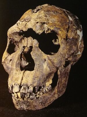
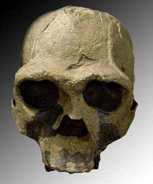
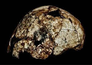
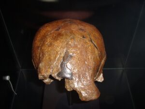
Turkana Boy skull. BAHN, Paul G, Public Domain, Wikimedia Commons
_____________________________
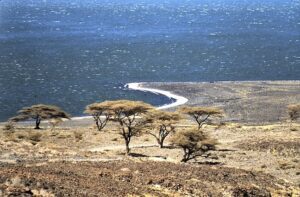
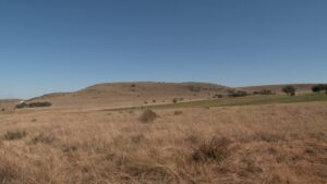
View of Lake Turkana. wfeiden, CC BY-SA 4.0, Wikimedia Commons. The landscape around Lake Turkana at the time of Turkana Boy was much wetter than it is today. A larger ancient paleolake existed instead of the current lake, surrounded by a savannah-like landscape of grasslands and scattered trees. Many scientists suggest that it was the transition from an environment thick with vegetation to that of a savannah that presented new challenges and impacted, in part, the course of human evolution, from the more ape-like ancestral predecessors to the bipedal, tool-making-and-using hominins that adopted a more varied diet of meat-eating, selective plant foraging, and more sophisticated scavenging and hunting strategies.
_____________________________
Other Finds
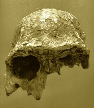
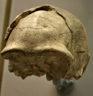
Astonishing as the Turkana Boy discovery was, it was certainly not the only Homo erectus fossil find emerging from East Africa. Most notable historically among the discoveries were three specimens; one, a nearly complete cranium designated with catalogue number KNM ER 3733; another, a partially complete cranium, designated KNM ER 3883, and the third, KNM ER 42700, also a partial cranium. KNM ER 3733 was discovered in 1975 at Koobi Fora, just east of Lake Turkana by Richard Leakey and his field worker Bernard Ngeneo. This cranium, dated to 1.78–1.48 million years ago, was determined to be an adult female based on the comparatively less robustness, the extensive teeth-wear, the presence of third molars, and fused cranial sutures — all tell-tale signs of adulthood. The KNM ER 3733 cranium is considered among the oldest Homo erectus fossils ever found. KNM ER 3883, discovered in 1976 also by Richard Leakey at Koobi Fora, has been dated to 1.6 million years ago. Larger and more robust than KNMR 3773, it is thought to represent an adult male. Notably, it shows a cranial capacity greater than 804 ml, suggesting a brain comparatively larger than most Homo erectus finds. Finally, KNM ER 42700, a cranium of a young adult individual, was discovered in northern Kenya, notably not far from where fossils of late-dated Homo habilis were found. Dated to about 1.55 million years ago, this fossil find has shifted thinking about hominins among scientists, suggesting that individuals or groups of Homo erectus and Homo habilis coexisted or overlapped in the same region at the same time.
______________________________
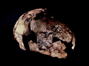
KNM-ER 3733 discovered by Bernard Ngeneo in 1975. CC BY-SA 4.0, Wikimedia Commons
______________________________
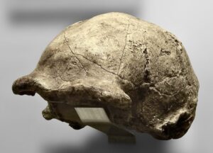
Homo erectus KNM-ER 3883 (replica, Senckenberg Museum, Frankfurt am Main, Germany). Gerbil, CC BY-SA 4.0, Wikimedia Commons
______________________________
KNM-ER 42700. Cast exhibited at the David H. Koch Hall of Human Origins at the Smithsonian Natural History Museum. Ryan Somma, CC BY-SA 4.0, Wikimedia Commons
______________________________
********
East Africa has long been thought to be the exclusive African domain for the earliest emergence of Homo erectus. But a remarkable discovery made in 2016 suggested otherwise….
_____________________________________
DNH 134
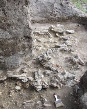
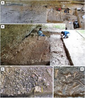
Piece by piece, they carefully and meticulously secured the fragments from their surrounding breccia sediment, where they had rested for millennia. These were clearly bone fossils — likely, they thought, to be the remains of an ancient baboon. Fossil baboon bones were long known to be plentiful in this cave.
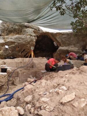
The excavators were members of a field school under a joint project of La Trobe University in Australia and Washington University in St. Louis in the United States. They were excavating at the Drimolen Main Quarry site, a paleocave site located within what is today called the Cradle of Humankind, an area north of Johannesburg, South Africa in the rolling grasslands of the Gauteng Province. The Cradle of Humankind is famous for the iconic fossils and countless artifact discoveries that have historically produced some of the earliest evidence of our human ancestry. But of all the ancient animal and plant remains that are recovered by archaeologists and other scientists in this region, actually finding fossils and artifacts that evidence the presence of humans or hominins in deep time is actually relatively rare. So it was very exciting when over the course of at least two field seasons, most notably from 2015 through 2016, the Drimolen team had recovered fragments that added to an eventual total of 150 individual fragments defining the skullcap portion of a primate cranium.
Another baboon?
Or could it be a hominin?
The first confirmation was made by Stephanie Baker, a researcher at the Palaeo-Research Institute and director of excavations and research at Drimolen. She had been working at the site since 2011, but this moment of discovery was one of the most exciting events of her life. It came one evening while she was sitting with a group of field school students while piecing together the cranium fragments during a lecture by one of her colleagues.
“I sat in back,” she explained, “not listening but rather focusing on the fossil fragments. By this stage I had reconstructed two large portions but couldn’t yet articulate them. I was looking through the fragments that had been excavated earlier that day and found one very small piece that was that ‘missing link’ between the frontal [forehead bone] and the occipital [lower back of the skull bone]. As soon as the two large portions fit together I gasped, louder than I had planned.”
The primate represented by this cranium was not what the initial observers had previously presumed it to be. She knew this for several reasons. First, the cranial fragments were relatively thin, a typical characteristic of cranial specimens identified in the fossil record as Homo — direct human ancestors. Secondly, the cranium featured an expanded occipital region, also typical of hominins. Thirdly, the foramen magnum (the hole in the bottom of the cranium that connects the head to the spinal cord) was anteriorly positioned (anatomically placed more forward toward the front of the skull as compared to other primates, such as gorillas and chimpanzees). Finally, the cranium was generally teardrop-shaped when viewed from above — also typical of a hominin.
This was not a baboon.
It was a hominin.
________________________________
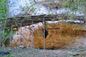
The savannah area that includes the Drimolen cave site. Therese van Wyk, University of Johannesburg.
________________________________
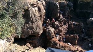
The Drimolen cave site as viewed from above. Therese van Wyk, University of Johannesburg.
________________________________
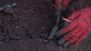
Excavating at Drimolen required careful, systematic, tedious digging. Therese van Wyk, University of Johannesburg.
________________________________
A South African First
Notwithstanding the thrill of having found a hominin fossil, Baker proceeded to do what any self-respecting paleoanthropologist would do — find out what kind of hominin she had.
For three million years, South Africa has been host to two genera and at least several different species of hominins. At Drimolen back in 1994, South African paleontologist Andre Keyser discovered the most complete skull ever found of Paranthropus robustus, a species of the australopithecine genus. Although Paranthropus robustus is a hominin, it does not fall within the Homo, or human, evolutionary tree. Paranthropus fossil crania fragments are typically very thick (a morphology that would have accommodated large teeth, adapted for heavy chewing), and the skull features a distinctive sagittal crest (see image, below). Baker knew the fossil fragments she was examining now were not those of another Paranthropus. For one thing, they were much too thin. She assigned the delicate and detailed task of further cranium reconstruction and identification to Jesse Martin, an a talented student at the field school. Martin, who showed early promise at reconstructing fossils in the field, enthusiastically took her up on the task.
“When I was a kid I loved putting jigsaws together, and reconstructing fossils is rather like completing a jigsaw puzzle without knowing what the end product is supposed to look like and with half of the pieces missing,” said Martin. But this assignment meant Martin had to leave Drimolen and go to a different location.
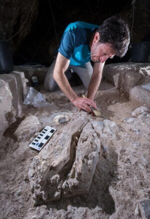
“The field is not the ideal place to undertake very fragile reconstructions, so we shelved further work on the cranium until after the excavations had been completed,” continued Martin. “After the excavations, my colleague Angeline Leece and I worked on the cranium over a two week period both at the University of Johannesburg and the University of the Witwatersrand where we had access to clean lab areas, materials, and comparative fossils. Once we had completed the final stages of the reconstruction in 2015, we began to compare the DNH 134 cranium [the designation assigned by researchers to the specimen] to other fossils housed at the University of the Witwatersrand to ascertain to which species it belonged.”
Key features of the cranium cap provided clear-cut clues. “There are a suite of derived neurocranial features that align the DNH 134 cranium with Homo erectus to the exclusion of other Homo species,” Martin elaborated. “Perhaps most striking, the long and low ‘teardrop’ shape of the neurocranium is a very distinctive Homo erectus trait. The cranial capacity of the DNH 134 cranium, remembering that it was only about two years old when it died and so still would have had some growing to do, is already pushing into the range for adult Homo erectus specimens.”
Martin and Leece thus already suspected that the specimen was Homo erectus, but they conducted an exhaustive comparative analysis. Then they arrived at their true eureka moment.
“When Angeline and I placed the completed reconstructions side by side with a cast of the KNM-ER 42700 Homo erectus cranium from eastern Africa, and started to sum the morphological traits that aligned DNH 134 with Homo erectus, it dawned on us that we had indeed found a very important early member of that species,” said Martin. “[We] spent a good couple of days convincing ourselves that our preliminary assignment to Homo erectus was warranted before we called our colleagues to share the news. As is often said in science, extraordinary claims require extraordinary evidence, and we wanted to be sure that the DNH 134 cranium provided the requisite evidence to partially rewrite the story of human evolution before we made that claim!”
After making the call to break the news, the reaction from Baker and her team colleagues was predictable. Homo erectus fossils were not known to exist anywhere in South Africa, and the earliest specimens of the species belonged to East Africa, where conventional scholarship assigned its birthplace.
“Initially we laughed, but after we went through his arguments, we were floored, then elated.,” said Baker.
Homo erectus walked South Africa.
_______________________________
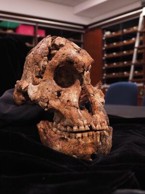
The Paranthropus robustus skull discovered at Drimolen is the most complete skull of this species ever discovered. Dr Herries, Creative Commons Attribution-Share Alike 4.0 International license, Wikimedia Commons
_______________________________
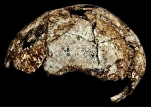
Above and Below: Detailed views of the DNH 134 Drimolen Homo erectus cranium. Dr. Matthew Caruana
_______________________________
_______________________________
View of the DNH 134 cranium skull cap from above. Therese van Wyk, University of Johannesburg.
_______________________________
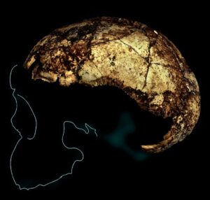
The DNH 134 Homo erectus cranium from Drimolen, South Africa produced from an Artec Space Spider 3D scanner. Image shows cranium skullcap in relation to estimated configuration of the rest of the skull. Andypithecus, Creative Commons Attribution-Share Alike 4.0 International license, Wikimedia Commons
_______________________________

For scale: Stephanie Baker with the DNH 134. Dr. Matthew Caruana
_______________________________
How Old?
The new finding was significant because Homo erectus, in contrast to the other hominins that traversed the South African landscape before the emergence of modern humans, was much more like us — they were among the first identifiable members of the genus Homo, the genus to which modern humans belong. They exhibited more human-like body proportions with shorter arms and longer legs, a more human-like gait, a larger brain, flatter face, and a more prominent nose. As makers of the Acheulean stone tool industry (which included the large, bifaced stone axes usually associated with Homo erectus from the archaeological record), they were perhaps also the first hominin to use fire and to journey out of Africa across the Old World with these technical capabilities, with a fossil presence from the Iberian peninsula in the west to Java in the Far East.
It was no wonder, then, that Baker and her colleagues hailed this as a spectacular find. The Homo erectus geographic range just got bigger.
Equally critical, however, was the question of age. To determine this, project researchers employed several different, state-of-the-art techniques. First, Dr Robyn Pickering of the University of Cape Town, South Africa, was called upon to direct the application of Uranium-Series (U-Pb) dating on samples taken from flowstone layers within the cave. The flowstone layers (sheet-like deposits of calcite or other carbonate minerals, formed where water flows down the walls or along the floors of a cave over time) acted as natural beginning and ending brackets for the key fossil-bearing sediments sandwiched between them. By measuring the trace amounts of uranium to lead (uranium decays at a known rate through time into lead) within the flowstone samples, the researchers were able to measure the age of the overlying and underlying flowstone layers. Second, Dr Renaud Joannes-Boyau of Southern Cross University, Australia, directly dated other fauna fossil teeth found in the same layers associated with the Homo erectus cranium by using Uranium-series Electron Spin Resonance (ESR). After being deposited in sediment, the teeth absorbed cosmic radiation, causing electrons in the teeth to reconfigure. Measuring this trapped energy within the teeth indicated how long the teeth had been in the ground. Finally, Prof Andy Herries of La Trobe University, Australia, oversaw the application of Palaeomagnetism to measure the global magnetic polarity of the grains of sediment samples. When sediments were deposited into the Drimolen cave anciently, they contained the effects of magnetic polarity (changes in the earth’s magnetic field) of the earth at the time they were deposited. A polarity log was created and correlated with an established polarity scale that is related to geologic time frames.
Combining all three methodologies effectively produced one of the most accurate and reliable dating episodes in paleoanthropological research. “Each of these techniques was used in combination to complement one another to provide as narrow a time range as possible,” explained Baker.
The results of this effort?
The Homo erectus cranium cap, and the other fossils found with it, were 1.95 to 2.04 million years old. This was older than most previous Homo erectus fossils in the fossil record. Now they knew that some of the earliest members of Homo erectus existed 150,000 to 200,000 years earlier than the age of many of the oldest known Homo erectus fossils to date, found in East Africa. The Homo erectus represented by the Drimolen fossil, however, lived in South Africa.
Hominin Diversity
For Baker and her colleagues, the DNH-134 finding is not the end of the story at Drimolen.
“The Drimolen Main Quarry still has many aspects to be explored,” Baker explained. “While the site is a relatively simple geological infill, the bulk of the excavation that has taken place prior to 2017 was focused on the central excavation area. This area is mostly decalcified, but also disturbed, by lime miners at the turn of the century.” Baker’s team has shifted to the western parts of the targeted excavation area where she says they will likely be working with better preserved specimens and better spatial data for analysis. Moreover, Baker’s research will extend beyond individual fossil finds. The fossils and dating revealed that Paranthropus robustus and Homo erectus lived in the Drimolen area simultaneously. Based on the paleoenvironmental research, at 2 million years BP both hominins were eking out a living in a changing environment, where a wetter, warmer climate was transitioning to a dryer, cooler climate with a more open, grassland landscape. But in this transition, Homo is thought to have had a better adaptive advantage. “Paranthropus and Australopithecus [the other hominin genus that shared the same South African landscape at the same time] evolved in warm and humid climates and were used to that,” said Baker in a news report from the University of Johannesburg.* “But then the weather began to shift from warm and humid, to cool and dry.” Baker hopes to continue research revolving around the dynamics of how this diversified population of hominins thrived and interrelated.
_____________________________
Homo erectus across time and space
As scientists have known for decades, however, that Homo erectus did not confine itself to the African continent. Incredible discoveries outside of Africa have shed light on the astonishing geographic diversity of the species. The first geographic clue, though unrecognized by scientists and scholars at the time, came with the historic discovery made by Eugène Dubois in Indonesia (Trinil in East Java) in 1891 with the finding of the skullcap and femur, which he initially assigned to a new species, Pithecanthropus (later changed to Homo erectus). Following this were the famous “Peking Man” (Homo erectus pekinensis) fossil discoveries at the Zhoukoudian cave site in northern China. Since the very first fossil tooth find unearthed there in 1921, the Zhoukoudian cave became the world’s most prolific Homo erectus site. About 13 years later, in 1934, scientists began uncovering numerous hominin fossils, including those of Homo erectus, at the site of Sangiran in Java in Indonesia, including the famous Sangiran 2 Homo erectus upper cranium dated to between .7 and 1.6 million years ago.
______________________________
The Peking Man skullcap. Gunnar Creutz, CC BY-SA 4.0, Wikimedia Commons
______________________________
Sangiran 2. collection Koenigswald, Senckenberg-Museum, Frankfurt am Main, Germany. Gerbil, CC BY-SA 4.0, Wikimedia Commons
______________________________
But perhaps equally spectacular was the stand-out discovery more recently made in a country of the Caucasus, bordering southeastern Europe….
______________________________
The Revelation of Dmanisi
While excavating among Medieval period ruins in 1983 near the town of Dmanisi in the Republic of Georgia, archaeologists encountered a jaw-dropping find. They had uncovered a partial set of fossilized teeth belonging to a rhinoceros — an ancient type that made its home thousands of miles away in places like present-day Tanzania, Kenya and South Africa.
The scientists were scratching their heads.
It just didn’t fit.
More fossils followed — mammoth, giraffe, saber-toothed cat. Clearly they had opened a door to a time long before anything they had come to expect from their excavations at Dmanisi. They were suddenly digging into a slice of the Early Pleistocene, between 1 million and 2 million years ago—when Europe’s environment was like that seen today in east and southern Africa.
But the excavators’ surprising encounters didn’t stop with animal fossils. Next came stones. Thousands of them. They were clearly shaped with intent, and not by nature. These bits of stone resembled in remarkable detail the kinds of simple stone tools first uncovered by Louis and Mary Leakey during the 1930’s at Olduvai Gorge in Tanzania. This was the very first human tool industry, known as the Oldowan, the advent of which is now generally accepted by scientists to have occurred about 2.6 million years ago.
So, here was the smoking gun. There must have been some form of human here contemporaneous with these ancient animals.
Shaking Up the Old Guard
It wasn’t until 1991 that workers at Dmanisi discovered the first direct evidence of a human presence within the Pleistocene layers. It was a fossilized mandible (the lower jaw), and it appeared to be human—but quite different from a modern human mandible. It was more like what scientists had been finding for decades in East and South Africa—fossils of what paleoanthropologists know to be some of the earliest members of our kind—genus Homo—human ancestors that lived between 1 million and 2 million years ago. Geographically, this fossil appeared to be several thousands of miles off course.
Even more remarkable finds were uncovered in 1999 — two similar skulls emerged. Two years later, a third. Then a fourth. One of the skulls had no teeth, only gums. Further examination showed that the individual had suffered an illness and had been toothless for about two years prior to death. How could such an individual survive in the comparatively harsher life conditions that must have existed almost 2 million years ago? Was this person cared for in sickness, as we do our fellow humans today?
These new finds were turning some widely accepted theories of human evolution on their heads.
“The prevailing view was that humans did not leave Africa until about 1 million years ago,” said David Lordkipanidze, paleoanthropologist and Director of the Georgian National Museum.* He had directed the excavations at Dmanisi for decades. He and his colleagues dated the new Homo fossils to about 1.8 million years ago using the latest dating technologies. Moreover, the morphology of the Dmanisi fossils seemed to be clearly ancestral to the later Homo erectus human species that had long been thought the first global colonizers. The Dmanisi specimens exhibited affinities to the earlier Homo habilis and Homo ergaster finds uncovered at African locations. And the stone tools were Oldowan — the simplest industry — not the more sophisticated Acheulean handaxe technology that at least some scientists contended was required to enable early humans to exit their African environment and survive as a global species.
In the time-honored fashion, Lordkipanidze’s discoveries were immediately met with controversy. “One group of scientists accepted [our interpretation], but mostly people were skeptical,” he said.*
With time, however, his discoveries at Dmanisi have joined the “who’s who” of fossil humans, and the research he and his team are doing today stands at the cutting edge of work in human evolution. Dmanisi is widely regarded as one of the world’s earliest early Homo sites outside of Africa.
But, Lordkipanidze and his colleagues were not through shaking things up in the world of human evolution.
Skull 5
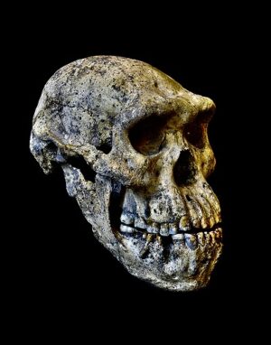
While excavating at Dmanisi in 2005, Lordkipanidze and his team uncovered yet another remarkably well-preserved early Homo fossil. Designated as specimen ‘D4500′, it turned out to be the matching cranium to another fossil find uncovered 5 years earlier — a complete mandible they designated ‘D2600’. These two fossils were discovered alongside the remains of the four other early Homo fossil skulls, animal fossils, and simple stone tools. Designated Skull 5, the new cranium together with its mandible display a relatively small braincase with a long face and large teeth. Other similar early Homo fossils, all found in African contexts, are either incomplete, or adolescent or younger individuals. According to Lordkipanidze and his associates, this new find constituted “the most complete adult skull known from Early Pleistocene Homo.“** Moreover, like some of the other finds, it was associated with other parts of the body that exhibited characteristics akin to Homo erectus body engineering, which closely approximates that of modern human morphology. In other words, this species had a very human-like body.
Skull 5 was another first. But the biggest revelation came not with the latest fossil, but with what the fossils collectively had to say about human evolution.
Now, with fossil finds that represented five distinct individuals, it was the first time that such an assembly of Early Homo fossils were found together within the same time and space context. No other site, in Africa or elsewhere, could boast of such a collection. The Dmanisi discoveries meant that scientists could study a range of variation in human species within the context of one place and time range, a relative mother lode of information that could potentially clarify, and perhaps even revolutionize, how we see these earliest of Homo human ancestors.
The researchers set to work. And the result of their study was startling. Lordkipanidze and his colleagues summarize it well in the following words in their recent report published in Science:
Geometric morphometric analysis and re-sampling statistics show that craniomandibular shape variation among the Dmanisi hominids is congruent with patterns and ranges of variation in chimpanzee and bonobo demes [a population of one species](Pan troglodytes troglodytes, P. t. verus, P. t. schweinfurthii, and P. paniscus) and in a global sample of H. sapiens. Within all groups, variation in cranial shape is mainly due to interindividual differences in size and orientation of the face relative to the braincase. The Dmanisi sample, including skull 5, thus represents normal within-deme variation, ranging from small-faced relatively orthognathic (typically female and/or subadult) individuals to large-faced relatively prognathic (typically male) individuals.**
In other words, after examining the remains, the research team concluded that the differences among these fossils vary no more than the differences between five modern humans or five chimpanzees.
“Thanks to the relatively large Dmanisi sample, we see a lot of variation,” said Christoph Zollikofer from the Anthropological Institute and Museum in Zurich, Switzerland—a co-author of the Science report. “Had the braincase and the face of Skull 5 been found as separate fossils at different sites in Africa, they might have been attributed to different species.”
Historically, variations among Homo fossil finds in Africa and Asia have also been found, but these differences have never been found within the same spatial and time period context, and thus scientists have classified the various finds as belonging to separate species. But now, according to Lordkipanidze and his colleagues, what has previously been thought to be separate ancient human species — Homo erectus, Homo habilis, Homo rudolfensis, and Homo ergaster, for example — may actually be variations or sub-species of one and the same species.
The upshot: Researchers need to re-adjust their thinking when determining how early Homo fossils are classified.
________________________________
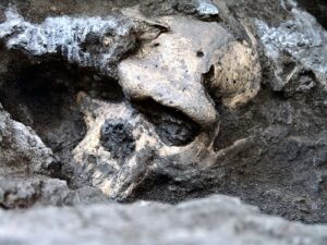
The Dmanisi early Homo cranium (D4500) in situ. Courtesy Georgian National Museum
________________________________
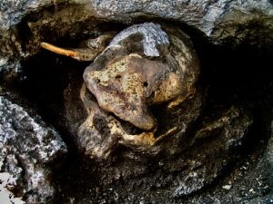
The Dmanisi D4500 early Homo cranium and a large rodent tooth in situ. Associated fauna, such as the tooth from a rodent species that lived 1.8 million years ago, helped to date the find. Courtesy Georgian National Museum
________________________________
The complete Skull 5. Courtesy Guram Bumbiashvili, Georgian National Museum
________________________________
The Erectus Ascendancy
The findings at Dmanisi compelled the researchers to propose a major overhaul of how these early Homo fossils fit into the larger scheme of human evolution, including the emergence of human ancestors from their African homelands. As Lordkipanidze et al. report:
When seen from the Dmanisi perspective, morphological diversity in the African fossil Homo record around 1.8 Ma probably reflects variation between demes of a single evolving lineage [emphasis added], which is appropriately named H. erectus……Specimens previously attributed to H. ergaster are thus sensibly classified as a chronosubspecies, H. erectus ergaster. The Dmanisi population probably originated from an Early Pleistocene expansion of the H. erectus lineage from Africa, so it is sensibly placed within H. e. ergaster and formally designated as H. e. e. georgicus to denote the geographic location of this deme.**
By this thinking, what Louis and Mary Leakey first uncovered at Olduvai Gorge, Tanzania in 1960 would not be Homo habilis, but Homo erectus habilis, what Kamoya Kimeu and Alan Walker discovered at Lake Turkana, Kenya in 1984 would not simply be Homo ergaster (the famous “Turkana Boy”), but Homo erectus ergaster, and what Bernard Ngeneo found at Koobi Fora on the east side of Lake Turkana in 1972 was not Homo rudolfensis, it was Homo erectus rudolfensis.
Most significantly, the evidence at Dmanisi, given its location and place in time, also implies something that challenges a long-standing paradigm in a big way: It was not the bigger-brained, bigger-bodied Homo erectus, with the more sophisticated Acheulean stone tools, that first ventured out of their native African comfort zone — it was the smaller-brained, smaller-bodied ones with the simple tools. And the exit out of Africa happened significantly earlier than previously thought. Scientists, these researchers suggest, will need to reconsider the elements required for early humans to become a global species.
Paleoanthropology, however, like many other scientific fields, has proven to be a science where theories come and go. Lordkipanidze and his research colleagues would likely be among the first to admit that their conclusions from Dmanisi are wide open to debate and further testing through future finds and research, at Dmanisi and elsewhere.
“Every year we are finding more and more,” says Lordkipanidze, “and we have excavated only 7 percent of the site.”*
That statement was made years ago. The percentage has gone up since then.
_________________________________

Dmanisi skulls 1-5 (left to right), showing the individual variations, and a Dmanisi landscape. Courtesy M. Ponce de León and Ch. Zollikofer, University of Zurich, Switzerland
____________________________________
Article Supplement
Homo erectus and the Anatomical Elements of Success
Homo erectus persisted over 6 times the currently known duration of Homo sapiens on the planet, with a global presence extending from South Africa to Indonesia. What accounts for the incredible success of this now extinct hominin species?
Arguably, some clues can be found in their morphology. The fossil evidence has shown that they were generally taller, sported longer arms, larger brains, a more humanlike bipedal gate, and more humanlike hands than other earlier hominins:
Larger, Smarter Brains
No characteristic has figured more prominently among scientists than the size of the human brain as an indicator for cognitive ability and thus the ability to survive and thrive as a species that otherwise would have been more vulnerable than other predatory mammals in their environment.
In general, hominin fossil evidence has revealed that, as the post-cranial part of the body (all anatomical elements below the head or skull) has increased in size, so too has the associated brain size. Data accumulated thus far shows that the smallest Homo erectus fossil examples indicated brain sizes only slightly larger than the earlier hominins, such as the australopithecines, whereas other examples, such as Turkana Boy, had brain volumes more than 50% larger than that of australopithecines. That translates to about 60% of the average modern human brain size. Most significant, however, is the proportional increase, or encephalization. The record shows that the cranial capacities of most later varieties of Homo erectus exhibited a volume of more than 1000 cm3, well within the lower recorded capacities of modern humans. This, even as the overall body sizes of the later varieties have not differed much from the earlier, more ancient specimens.
_____________________________
Endocast of an adult Homo erectus, on display in the Hall of Human Origins in the Smithsonian Museum of Natural History in Washington, D.C. An endocast is produced when the inside of the cranium is filled with a substance that creates a mold of the cranium interior. The brain and its blood vessels leave imprints on the inside of the skull. Because more advanced brains have smaller veins and many more folds and lobes, an endocast is very useful in determing how intelligent a human ancestor might have been, and what portions of its brain were more developed. Tim Evanson, CC BY-SA 4.0, Wikimedia Commons
_____________________________
Walking Like Us
The structural interpretation and analysis of Homo erectus fossil remains have led scientists to suggest very conclusively that this species was bipedal, a characteristic essential to higher energy efficiency for traveling across the landscape, enabling a greater ability to explore and inhabit spaces across the surface at greater distances. Earlier hominins, such as Lucy the australopithecine, however, have also been determined to be bipedal, although with a less modern human-like gait and a more prevalent tree-climbing lifestyle. An operative consideration, therefore, may revolve equally around the gait of movement as much as being erect and moving on two limbs. The discoveries at the site of Ilert on the northeastern shore of Lake Turkana in Kenya have a story to tell about this.
Ileret
It was in 2012 and 2013 when a scientific team discovered hominin fossils representing three individuals. The finds included two partial skeletons and one mandible. The mandible and one of the partial skeletons was dated to 2.02 to 2.03 million years ago and one partial skeleton was dated to approximately 1.82 to 1.86 million years ago. The partial skeletons have been classified as belonging to Homo erectus, and the mandible was assigned to Homo habilis, suggesting that Homo habilis and Homo erectus occupied or traversed the region at the same time.
Ileret is perhaps most significant in the popular literature, however, for the rare discovery of two trails of fossilized footprints, thought by scientists to have been made by a striding group of Homo erectus individuals about 1.5 million years ago. The footprints have provided a rare glimpse of Homo erectus foot anatomy and stride, providing more detailed information about how this species traveled and confirming the long-held suggestion that they walked much like modern humans, more so than any other earlier hominin species.
With this, Homo erectus was well-equipped to more efficiently travel the globe.
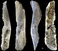
Hands Like Us
It was again within the scrubland environment of Lake Turkana where a team of scientists spied what appeared to be a fossil hand bone eroding out of the surface in 2011. After excavation, the team sent a cast of the fossil to Carol Ward, professor of pathology and anatomical sciences at the University of Missouri, for detailed analysis. She concluded that the fossil hand appeared to be almost as developed as that of a modern human. She based this at least in part on the fact that the styloid process feature of the hand, otherwise described as a projection of bone at the base of the third metacarpal, was anatomically key to making it possible for much greater strength of the gripping and articulation of the thumb and fingers of the hand necessary for the creation of complex tools. This feature and function was lacking in other early hominins and most certainly other primates.
The age of the fossil?
It was dated to 1.42 million years ago. Time and context of the find suggested it belonged to a Homo erectus individual.
“With this discovery, we are closing the gap on the evolutionary history of the human hand,” said Ward, as published in the subject University of Missouri news release in 2014. And “toolmaking was critical to the survival of these animals”.***
Homo erectus is known for creating the Acheulean stone tool industry. These tools were found in association with or in the context of sediments in which Homo erectus fossils were discovered. This industry is more complex and sophisticated than the earlier stone tool industry known as Oldowan, which has been identified with early hominins such as Homo habilis. Acheulean is typically characterized by lithic flakes larger than 10 cm (3.9 in), and bifacial hand axes, including other bifacial tools such as picks, knives, and cleavers. The handaxes are thought to be multi-purpose tools that were used for such activities as cutting meat, wood, and plants.
For Homo erectus, cutting meat was crucial, as their diet was likely dominated, based on archaeological evidence, on the consumption of large animals. Scientists have suggested that the high-protein consumption resulting from meat-eating was a key to human brain development.
_______________________________
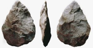
Acheulean Handaxe. José-Manuel Benito Álvarez, CC BY-SA 4.0, Wikimedia Commons
Manipulating the Environment
All of these morphological factors are postulated by scientists as playing a salient role in the superior ability of Homo erectus, as compared to their hominin predecessors, to manipulate their environment to enhance their ability to survive and thrive. The production and use of Acheulean stone tools as well as the controlled use of fire (as evidenced by the findings at Wonderwerk Cave in South Africa, for example) are considered milestones in the evolutionary progression and definition of this species’ existence.
_______________________________________
Return to Ngandong
Sites like those of the Turkana Basin, Dmanisi, and Trinil have stood for years among the earliest sites evidencing a Homo erectus presence. Eventually, more sites across Central and East Java have also emerged with fossils (200 in all) and artifacts testifying to a long chronology for the hominid’s existence on the island, from Sangiran, where the oldest fossil specimens have been found, dating to at least 1.5 million years ago, to Ngandong, where the last known presence of the species has been documented. The dating at Ngandong, however, has been a subject of scholarly debate for decades.
Enter paleoanthropologist Russell Ciochon from the University of Iowa in Iowa City, who for years has been conducting fieldwork on Java to explore evidence for the initial migration of early human ancestors into the region. “I conducted fieldwork at Sangiran, the oldest known Homo erectus site on Java, from 1998 to 2006,” wrote Cionchon to Popular Archaeology. “After studying the arrival of Homo erectus on Java, we decided that it would be interesting to examine the extinction of Homo erectus. During our 2006 field season, we took a trip to Ngandong to determine the potential for re-excavation. We were able to successfully obtain funding for new excavations at Ngandong.”
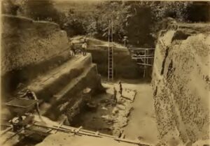
With that, Ciochon co-led an international team from the University of Iowa, Macquarie University, and the Institute of Technology Bandung, Indonesia, to the banks of Java’s Solo river, beginning in 2008. The team was tasked to re-excavate and investigate Ngandong’s original bone bed, where in the early 1930’s German-Dutch paleontologist and geologist Gustav Heinrich Ralph von Koenigswald excavated 25,000 fossils, 14 of which belonged to the hominid species identified as Homo erectus.
The team’s mission was clear. “There were very few methods to date a site in the 1930s,” explained Ciochon. “At that time, sites were dated based on relative dating methods such as comparing fauna to other sites on Java and across Asia. From the relative dating, they were able to determine that Ngandong was the youngest site, but not how much younger.” The re-investigation, which included fieldwork at the site in both 2008 and 2010, would afford the opportunity to employ the latest state-of-the-art techniques to find answers. “Previous attempts had always focused on the fossils themselves, and that was always problematic,” said Kira Westaway, associate professor at Macquarie University and a member of the team and joint-lead author on the project study paper published in Nature. “So we tried a different approach. We looked at trying to date the sediments that the fossils were actually buried in. These sediments are river sediments and they deposited within a river terrace, which is a former level of the flood plane surface. Our attempt was to date how these fossils sit within the bigger puzzle of the landscape system.”
The initial challenge required the excavators to first re-locate the original bone bed layer that contained the 14 Homo erectus fossils. Beginning with a 1934 site map created by the original excavators, the site researchers explored the site using landmarks, the application of geological horizons, excavation pits, and applying a total data station (TDS) to accurately record the precise locations of all fossil finds throughout the excavation process. They were able to locate the bone bed in two different locations, taking samples of the strata for later dating. Using surface height measurements, they also created a topographic reconstruction of the site, generating a 3D model for analysis. In addition, the researchers studied the broader landscape context of the site, determining the course of the Solo river relative to the site through time and developing the geologic river terrace sequence.
Once the excavations were completed, the team submitted the soil samples from the bone bed to labs for dating using uranium-series, luminescence (OSL), argon, and uranium series electron-spin-resonance (US-ESR) testing. By combining the results from the different methods using Bayesian modeling, the team was able to finally produce a more reliable date range for the bone bed.
The results became worldwide news.The Homo erectus fossils were dated to between 108,000 and 117,000 years ago. These fossils were even younger than previously thought, and younger than any Homo erectus fossils found anywhere in the world.
_____________________________
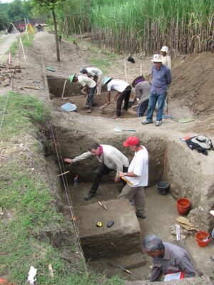
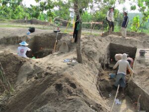
Above and below: Excavations underway at Ngandong in 2010. Russell L. Ciochon, University of Iowa
_____________________________
_____________________________
Exposed bonebed from 2010 excavations at Ngandong. Russell L. Ciochon, University of Iowa
_____________________________
Above and below: Homo erectus fossil replica from Ngandong. “None of the skull caps from Ngandong are fully intact, but several of them are complete enough to provide estimates of cranial capacity which is used as a proxy for brain size,” explains Ciochon. “The Ngandong Homo erectus fossils have the largest cranial capacity of any Homo erectus fossils. But without additional evidence for behavior, we are unable to say that they were smarter than other Homo erectus groups. The cranial capacity of Homo erectus at Sangiran, Java (the oldest, or earliest, site on Java) is 840 to 1050 cubic centimeters, and the Ngandong range is 1,035 to 1,255 cubic centimeters. The cranial capacity of Ngandong Homo erectus overlaps with the lower end of the modern human range. There are [also] some changes in the shape of the Homo erectus skull caps that make them distinct from other earlier Homo erectus fossils including a higher forehead. Due to the large brain size, Ngandong Homo erectus is referred to as the most derived, advanced, Homo erectus. Image credit: Kiran Patel, University of Iowa
_____________________________
The Last Stand?
One could argue that, on the island of Java, our Homo erectus ancestors made their last stand — that they were the last of the Homo erectus species. But while it is true that, to date, there is no evidence anywhere in the world of a Homo erectus presence any later than Ngandong, Ciochon and his colleagues caution against the conclusion that Ngandong marks the time just before the species extinction.
“Our work provides the age of the last known appearance of Homo erectus, but this does not mean that it is the age of extinction,” said Ciochon. “Small groups of Homo erectus may have lived longer [at other locations] without leaving fossil evidence.”
But even if the Ngandong fossils represent some of the last Homo erectus to persist on the planet, assuming that no similar fossils of the species of equivalent or later dates are found on Java, what caused their decline and extinction on the island? Ciochon and his colleagues point to major environmental changes that were in the works at the time.
“Humidity and moisture levels on Java vary between glacial and interglacial periods,” explained Ciochon. “When the area became wetter, the rainforest expanded east across Java replacing the open woodland environment associated with Homo erectus. The demise of Homo erectus on Java coincides with this rainforest expansion, and the changing environment likely contributed to the demise of Homo erectus.”
But, here again, Ciochon qualifies his statements. “We can only speculate on why Homo erectus was unable to adapt to a rainforest environment. They might not have been able to find food sources they normally ate, or they might have been more vulnerable to the predators in the rainforest.” Or there could have been possible causes that have never been fully considered or studied: Such as ecosystem changes that can introduce new flora and fauna, which in turn could introduce new micro-organisms causing diseases that could decimate or wipe out entire groups or populations of animals, including Home erectus.
In any case, the Ngandong finds have served to buttress two major implications. First, Ciochon asserts, “we have ended a long controversy over the age of this important site in human evolution”; and second, “Homo erectus was an incredibly long-lived species with a massive geographic distribution which makes it one of the most successful hominins that ever lived.”
_______________________________
Palaeoanthropological site of Trinil, Java, Indonesia, where Eugène Dubois first discovered Pithecanthropus (now Homo) erectus in the 1890s. Selenka and Blanckenhorn 1911: Tafel III, Public Domain, Wikimedia Commons
__________________________________
Homo erectus in Spain?
More than any other site, the name ‘Atapuerca’ has become synonymous with the discovery of the oldest known ancestral humans in Western Europe. Located near the town of Burgos in Northern Spain, it has yielded unarguably the richest trove of hominin fossils bearing on the early presence of humans on the subcontinent. The iconic discoveries here have revolved around the unearthing of fossils belonging to individuals of several different species, including Homo antecessor and Homo heidelbergensis, spanning a range extending back hundreds of thousands of years. Of special note is the discovery of several hominin fossils in one of the Atapuerca cave system sites, Sima del Elefante, that has yielded fragmentary fossil specimens that have been dated between 1 million and 1.4 million years ago.
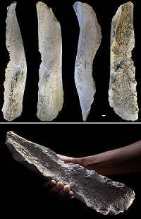
Now, a team of scientists led by IPHES-CERCA, a transdisciplinary research institution in Tarragona, Spain, has assigned one of those finds—an ancestral human (hominin) midface fossil fragment, to a new hominin species designated as Homo affinis erectus. Dated to between 1.4 million and 1.1 million years ago, the fossil (ATE7-1) was initially discovered in 2022. According to the research study**** authors, “this fossil (ATE7-1) represents the earliest human face of Western Europe identified thus far”.
The first Homo erectus in Western Europe as far back as 1.4 million years ago? The certainty is not ironclad. But the new finding adds to the growing story that Homo erectus was indeed our first globe-trotting ancestor.
_______________________________
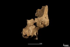
Original fossil (ATE7-1) of the midface of a hominin assigned to Homo aff. erectus recovered at level TE7 of the Sima del Elefante (Sierra de Atapuerca, Burgos). Credit: Maria D. Guillén / IPHES-CERCA. Maria D. Guillén / IPHES-CERCA.
_______________________________
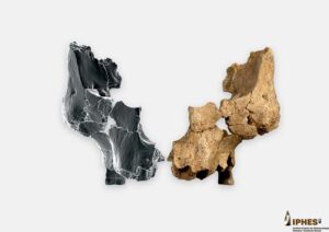
Original fossil (ATE7-1) alongside the mirrored right side by means of virtual 3D imaging techniques of the face of a hominin assigned to Homo aff. erectus found in level the TE7 of Sima del Elefante site. Credit: Maria D. Guillén / IPHES-CERCA / Elena Santos / CENIEH. Maria D. Guillén / IPHES-CERCA / Elena Santos / CENIEH.
_______________________________
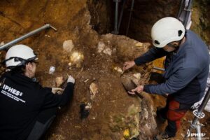
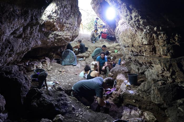
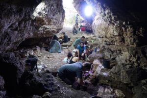
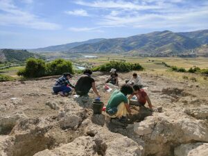
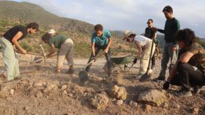
Archaeological excavation work at level TE7 of the Sima del Elefante (Sierra de Atapuerca, Burgos). Credit: Maria D. Guillén / IPHES-CERCA. Maria D. Guillén / IPHES-CERCA.
_______________________________
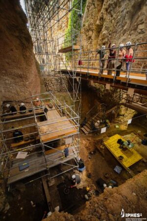
General view of the archaeological excavation work at the Sima del Elefante site (Sierra de Atapuerca, Burgos). Credit: Maria D. Guillén / IPHES-CERCA. Maria D. Guillén / IPHES-CERCA.
_______________________________
* Lordkipanidze, David, “The First Humans Out of Africa”. Posted March 2012. TEDvideo, 15:27. http://www.youtube.com/watch?v=dC0gdpVS4uM
** David Lordkipanidze, et al., A Complete Skull from Dmanisi, Georgia, and the Evolutionary Biology of Early Homo, Science 342:326-331, 2013.
***Hominid bone indicates that human hand evolution mostly complete by 1.42 million years ago, University of Missouri, January 23, 2014, Volume 35, No. 16. https://mizzouweekly.missouri.edu/archive/2014/35-16/bone/index.php.html
****Huguet, R., Rodríguez-Álvarez, X.P., Martinón-Torres, M. et al. The earliest human face of Western Europe. Nature (2025). https://doi.org/10.1038/s41586-025-08681-0
_______________________________
This article combines content from three previously published premium articles with new, additional content.
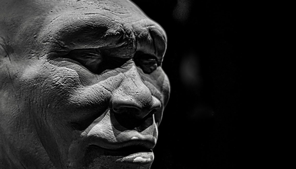
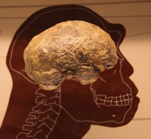
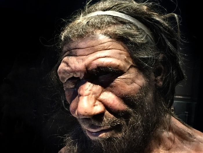
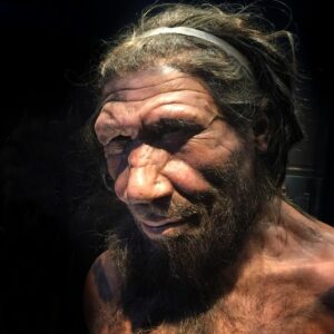
Cover Image, Top Left: Facial reconstruction of Homo erectus. Werner Ustorf, CC BY-SA 4.0, Wikimedia Commons
_______________________________
Advertisement

EXPLORE THE ANCIENT ETRUSCANS IN PERSON!
Experience a unique, up-close-and-personal hike among ancient hilltop towns in central Italy. You will walk the sensational countryside of the regions of Umbria and Tuscany, soaking in important sites attesting to the advanced Etruscan civilization, forerunners of the ancient Romans; imposing architectural and cultural remains of Medieval Italy; local food and drink; and perhaps best of all — spectacular scenic views! Join us in this collaborative event for the trip of a lifetime!


.jpg)