
The cluster of valleys on the banks of the Supe River in the north-central coastal region of Peru, known as the Norte Chico, stands out among other geographical areas for the number, size, and complexity of its very early monumental ancient human settlements. It is a witnesses to an extraordinary past. Its early urban centers include Banduria (4000-2000BC), Aspero (3700-2500BC), and Caral, also referred to as Caral-Supe (3500-2000BC). Caral far surpasses the other two in power and influence and has been called “the oldest city in the Americas, and one of the earliest cities in the world” (Mann, 2005). In fact, the rise of civilization in Peru preceded the Olmec civilization, believed to be the oldest in Mesoamerica, by at least 1500 years (Shady, 1994). However, unlike cultures in other parts of the world, the Peruvian urbanization took place in total isolation.
The Beginning
Hunting and gathering for subsistence, in what is now Peru’s Norte Chico, is documented as early as 9500-8000BC. Small groups started plant selection and gardening, and the remains of irrigation channels have been dated to that period. New concerns with the cosmos and religion led to the unification of nascent social groups around spiritual concepts. In turn, this collective perception brought social stratification, followed by an economic cooperation that swept the Andes and Northern Peru’s coastal communities (Shady, 1997). Agriculture expanded, and by 3200 BC, harvested cotton was an already important trade crop, used to make nets for fishing, and later net-bags (shicras) employed in construction. Domestication of camelids such as llamas also grew around this time.
____________________________________
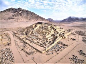
The Great Pyramid @peruinfo.com
____________________________________
The Rise
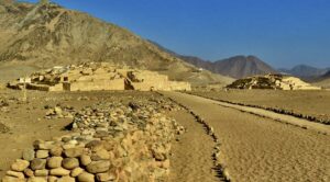
So, let’s follow the field notes of renowned Peruvian archaeologist Ruth Shady Solis and others, to look at how ancient civilizations in this region rose and fell. The fertile Supe River and its affluents wind their way to the coast from the western piedmont of the Andes to the dry coastal plains. Its lush valley is host to twenty-one ancient settlements that share a common architecture and urban distribution dating from the Late Archaic period (3500BC). On the Pacific Coast, at the mouth of the Supe River, is the Late Archaic site of Aspero (3700-2500 BC). This coastal town seems to be the origin of human settlement in this part of the Norte Chico. As demographic pressure increased at Aspero together with social complexity, communities split into groups that moved up the Supe River valley, establishing villages upstream. Aspero’s location, however, gave the town a key role in the initial economic development of the region, providing access to the abundant schools of fish that rode the cold northbound Humboldt current, as well as control of the sea salt trade with growing inland communities.
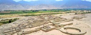
Caral and other close communities were built fourteen miles up the coast in the 60-mile-long Supe River valley, on the arid plateau extending on both banks of a ravine and the fertile but narrow valley where crops were planted. The settlements on the plateau on each of the upper sides of the ravine were thus protected from seasonal floods. In the 3500-3200 BC time frame, Caral (165 acres) grew from a village to a city together with Era de Pando (200 acres) and Pueblo Nuevo (135 acres), while neighboring hamlets such as Cerro Colorado, Liman, or Cerro Blanco did not exceed two or three acres.
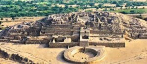
By 3000-2900 BC, Caral was the seat of regional power, with Curacas – or heads of lineages – in control of political, socio-economic, and religious affairs. The foremost Curaca was the principal of a network of districts that spread up from the Pacific coast to the foothills of the Andes, an organization that was based on trade and reciprocity (Shady, Dolorier, Casas, 2000). What kept the network together was religion, used as a means of cohesion and coercion, as well as a symbol of mutual cultural and spiritual identity (Shady, 2004). Today, Caral’s monumental pyramidal stepped structures associated with sunken circular plazas, emphasized its importance as a secular and religious power center. Its seven massive temple-pyramids dot the landscape together with remains of residential complexes large and small. Its antiquity as the oldest in the Americas has been confirmed by 29 radiocarbon dates (Shady, 1993, 2000).
____________________________________
Caral site map. @mdpi.com
____________________________________
Caral and its neighboring communities on both sides of the Supe River may have housed over 20,000 people. Shady stresses, in agreement with Feldman (1980) and Grieder et al. (1988), that “field research indicates that the Caral-Supe society was organized into socially stratified ranks with local authorities connected to a state government, sustained by a productive and diversified crop production and fishing economy.” Farmers cultivated fields irrigated by means of a simple system of canals guiding water from the Supe River and its affluents, as well as from numerous springs.
The socio-economic dynamics were driving internal and external exchanges that allowed for the development of complex technological and social organization. “Caral’s direct control and economic dominance included populations of the Supe, Pativilca and Fortaleza valleys. Its interaction and prestige extended across the entire north-central Peru region from the Andes foothills to the coast. Furthermore, Shady stresses that evidence shows that “Caral was the model of a socio-political organization that other societies achieved only in later times throughout Peru” (2002).
The impressive achievements of Caral’s inhabitants (called Caralinos by archaeologists), from architecture to religion is owed to their dynamism, creativity, and interactions with social groups in the upper reaches of the Andes. Caral’s history and culture was closely associated with its ceremonial calendar which was set in harmony with nature and the seasons. However, they were also influenced by two major natural disrupters that are historically associated with the demise of cultures in northern Peru. These disrupters were, and still are, inextricably linked to the ebb and flow of Norte Chico cultures. The first of the disrupters are the combined climate episodes triggered by El Niño and La Niña, which affect global weather patterns. In a few words, El Niño is associated with a band of nutrients-poor warm water and atmospheric convection that develops in the east-central equatorial Pacific and spreads to South America’s east coast. ENSO-El Niño Southern Oscillation refers to the cycle of warm and cold Sea Surface Temperature (SST) of the tropical central and eastern Pacific Ocean, with high air pressure in the western Pacific and low air pressure in the eastern Pacific.
El Niño’s moisture-laden clouds produce intense rains, floods, and landslides, devastating cultures and could be, but is not always, followed a year or so later by La Niña, the El Niño colder counterpart. During La Niña episodes, strong winds blow warm water on the ocean’s surface away from South America across the Pacific Ocean. SST in the eastern Pacific is, at that time, below average. Cold water from the ocean then rises to the surface near South America’s coast. La Niña is associated with droughts that may last months over the South American continent. These complex occurrences vary in intensity and may recur in cycles of seven or fourteen years.
______________________________
Peru Tectonic Plates @Scott Nash-USGS/Wikimedia Commons
______________________________
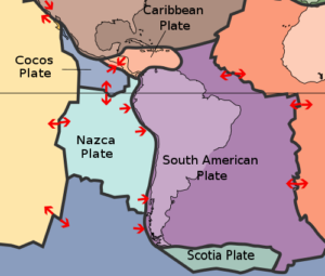
The second set of disrupters are earthquakes triggered by the collision of the massive South American tectonic plate and the far heavier Nazca plate as it moves eastward from the Pacific and slides beneath the South American plate. The friction between the plates, in the subduction zone along the Peru-Chile trench, is the main cause of earthquakes and volcanic activity in the region. To mitigate the disruptive effects of earthquakes, Caralinos found an ingenious way to give their constructions a certain “flexibility” during seismic events. Their answer was the shicra, a net made of cotton mixed with vegetal fibers that was packed with loose rocks. Shicras that held over a thousand pounds of rocks were found in the foundations of structures. Smaller shicras were used to carry stone loads of fifteen to twenty pounds from quarries to building sites, where they were placed in retaining walls to allow structures to absorb a certain number of disturbances from quakes with little or no damage.
Together with the shicras, quinchas-lintels or beams made of the huarango, a hard wood of a mesquite tree species such as the “algarrobo blanco” (Prosopis alba), were used to shore up doors and passageways in buildings, along with massive stone pillars as central support. All structures, large and small, were built of shaped stone blocs set with mud.
_______________________________
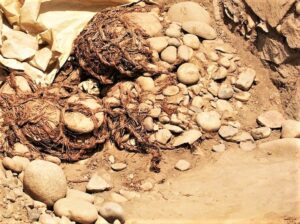
Shicra Nets @Xauxa – wikipediaPD, CC-BY-SA 2.5
_______________________________
Monumental Florescence
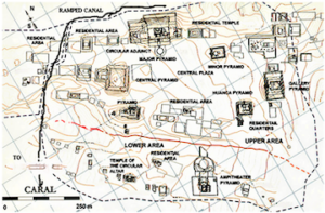
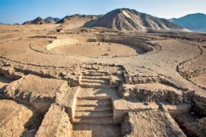
Caral’s thirty-two monumental structures, and its residential complexes, large and small, underscore the ancient city’s importance. In the upper half of the city are seven large pyramidal structures. Two of them, the Great Pyramid, and the Pyramid of the Amphitheater, are associated with large sunken circular courts. Major structures encircle multifunction open spaces or plazas. There are two subgroups: the one to the west includes the Great Pyramid, the Central Pyramid, the Quarry Pyramid, and the Lesser Pyramid. The subgroup to the east includes the Pyramid of the Amphitheater, the Pyramid of the Gallery, and the Pyramid of the Huanca (a huanca is a tall upright monolith, usually an uncarved stone). The eight-foot-tall huanca is found three hundred feet away from the plaza and the two pyramids, at the end of a causeway.
Archaeologist Shady notes that at Caral “the structures in the nuclear space are grouped into two great halves: an upper half, nearest the water where the most impressive pyramidal structures are located, and a lower half with smaller public buildings, but for one large complex that also has a circular sunken court attached to it” (2002)
This spatial organization likely expresses the Andean binary division into hanan and hurin (upper and lower, respectively). Pyramidal structures vary in size and exhibit distinct elements, but all share a model for the façade, which are comparable in style and design. Shady remarks that “all buildings follow a similar model with superimposed terraces placed at intervals and contained by stone walls. Each façade has fixed stellar direction and an axis that internally divides the space. This axis is usually marked by a staircase traversing the center of the terraces from the base to the summit. The flight of stairs also divides the building into a central body with two left and right extensions, each with rooms and passageways. The central body of each structure consists of segments set apart by their sequential location at specific elevations” (2001).
______________________________
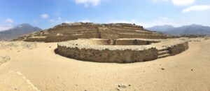
Circular Court Complex @georgefery.com
______________________________
* * * * * * * * *
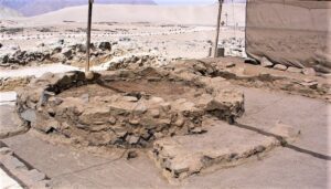
An exhaustive description of this 5000–year-old city would require far more space than is available here. So, together with archaeologists Shady, Machacuay and Aramburu, we will focus on three major structures: the Great Pyramid (Sector.E), the Pyramid of the Galeria (Sector.I), and the Temple of the Amphitheater (Sector.L). The Great Pyramid is the largest and most extensive and important complex in the upper half (hanan) of the city. It measures 561 feet from east to west and 495 feet from north to south. Its south facing façade is 65-five feet in height while its north side, facing the valley, reaches to slightly less than 100 feet. Its main feature is an important circular sunken court and an imposing stepped pyramidal structure made of a central body and two side components.
An important feature in the structure is that of the Altar of the Sacred Fire, which is located at the top of the pyramid, in a small quarter with a ventilation shaft running below it. The diameter of the circular sunken court, attached to the north side of the pyramid, is 120-feet, and its sunken interior is 72-feet across. An entrance stairway leads up from the exterior and up the south side of the court, in line with the axial staircase of the pyramid. On the north-south axis, two other staircases descend to the court, each framed by two large upright monoliths. The internal wall of the court is made of stone blocks reset one-and-a-half feet to an elevation of five feet giving it a stepped appearance. The walls, stairs and floors of the plaza were plastered and painted. Given its size, location, and association with the circular court, this was probably the city’s main public building” (2000).
__________________________________
Pyramid la Galeria and the Huanca @georgefery.com
__________________________________
The Pyramid la Galeria owes its name to the monolith located about three hundred feet from the pyramid’s main stairway. This pyramid is of a quadrangular plan, located in the east subgroup, at the extreme southeast of the upper half of the city (hanan). The façade is oriented toward the urban space shared with the Pyramid of the Gallery (Sector.H). The eight-foot-high monolith or huanca, seems to have been the axis common to the two buildings. The Pyramid of the Huanca has the typical stepped profile, consisting of five superimposed terraces and four sides. It measures 177 feet on its east-west axis, 171 feet from north to south and reaches 42 feet in height. Its eighteen18-foot-wide central stairway leads at the summit to an atrium, assumed to be an observatory. Notable among the finds in the building, is a headdress made of grassy fiber.
__________________________________
The Great Pyramid and the Supe Valley @cordilleraviajes.com
__________________________________
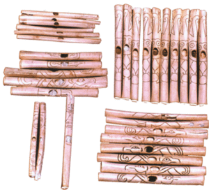
The Complex of the Amphitheater and its monumental circular sunken court is dated to 2160 BC. It is an important structure in the lower part (hurin) of the city, the counterpart to the Great Pyramid (hanan), but is not as commanding as the latter. The walled complex is made of various components: a deck with a series of aligned cubicles; a large circular sunken plaza and a building with platforms that ascend sequentially. “On the east side of its perimeter is a circular altar and an elite dwelling. In the building were found several ceremonial hearths or Altars of the Sacred Fire, with their ventilation shafts built underneath. Buried in the circular sunken plaza of the Amphitheater were found 32 flutes finely carved from condor and pelican bones, as well as 37 bugles made of deer and llama bones, which point to the building’s ceremonial importance. They were “decorated with incised designs and painted with figures of local fauna and humans” (Shady, 1999b).
* * * * * * * *
The main Altar of the Sacred Fire was found in an isolated area within the wall encircling the Amphitheatre complex. The religious ceremonies that took place there, as for most ancient agrarian societies, revolved around the powers of the sun, the moon, water, earth, celestial bodies, and their respective deities. This religious structure stems from the Kotosh religious tradition of the Late Archaic (4200 BC) in the upper Andes, which influenced Caral religion through most of the millennium between 3000 and 2000 BC.
________________________________
Altar of the Sacred Fire @en.wikipedia.org
________________________________
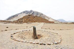
The priests were believed to draw their spiritual power from predicting cyclical natural events, such as the cycles of the sun, the moon, and other heavenly bodies. For that reason, they were acknowledged as the anointed intercessors between people and the deities of nature. However, the priests lacked the scientific knowledge associated with their observations that would be acquired much later in time, so they merely acknowledged the repetition of those events that indeed appeared at predicated times. But what the priests could not predict were nature’s variables such as the intensities of the above-mentioned disrupters. At Caral as in most societies of the past, there was no separation between secular and creed for, as Shady notes, “religion was the nexus of cohesion and the ideology of the state acted as the instrument of domination of its government. Most of the activities carried out at Caral were, in some form or another, related to religious rituals and sacrifices” (1999a). The most important religious ceremonies may have taken place around the Altars of the Sacred Fire in the Great Pyramid, as well as in that of the Amphitheater. Less important ceremonies took place in other buildings. The shrine for the Sacred Fire is often made of a small circular platform with a fire pit in which small offerings were burned, such as those found at Kotosh.
The circular platform of the Sacred Fire was enclosed in a low quadrangular six-foot-high wall open space with access for only one person, most probably the high priest. A ventilation duct was built underneath the hearth that led the heat and smoke outside. In the shrine, the high priest called on natural forces and their deities to ascertain the timely arrival of natural events such as rains, winds, or other phenomena, and their consequences on crops. Planting and harvesting were daily concerns for most societies of the past associated, as they were, with the weather — rain, specifically. Delayed rains, or their diminished downpour, could translate into a bad or no crop at all, and the consequences: famine, the return of fear, and death. So the priests had to assure the city’s elite that the gods indeed helped in understanding nature’s hidden behavior.
________________________________
Amphitheater Sunken Court @qosqoexpeditions.com
________________________________
* * * * * * * *
Two other prominent architectural features at Caral are the large sunken circular courts built at the foot of the monumental staircases of the Great Pyramid and the Pyramid of the Amphitheater. They were used, as were the Maya rectilinear ball courts, for multi-function events at dedicated times. Religious ceremonies were likely prominent to celebrate major events such as spring and autumn equinoxes, the Austral solstices and the rising and setting of stars and planets mythologically associated with gods, deities, and seasonal celebrations, such as planting and harvesting. The discovery of finely carved flutes and bugles beneath the Pyramid of the Amphitheater’s sunken court, point to the importance of musical instruments used during ceremonies and pageants. Remains of drums have not been found, so far, for their material may not have survived the test of time. Drums or percussion instruments, however, are recorded far back in time as the oldest device used by most cultures. Secular games may have taken place in the arena-like courts to celebrate social and sport events, an answer to ingrained human needs to compete in a controlled environment.
Through history, the universal use of games for secular or ritual purposes, underscore a commitment to maintain peace and balance between communal factions. Essential to ritual games, and to a certain extent secular games as well, was the need to keep in check latent antagonism within the same polity, as well as between polities.
_______________________________
Condor and Pelican Bone Flutes @noticiasdelaciencia.org
_______________________________
* * * * * * * *
In several buildings, archaeologists found human burials, mainly of children or young adults that are generally associated with specific rituals. As Shady points out, “the discovery of the body of a young man, deposited among stones that were used in an atrium in preparation for the construction of a new one, demonstrates this concept. The body was found above a layer of soil and stones, covered with other stones and the floor of the new atrium. It was nude and had no offerings except for the careful arrangement of the hair. Forensic analysis by Dr. Guido Lombardi indicates that it was a male of about twenty years of age, who was subjected to hard labor for most of his short life. He had received two forceful blows, one to the face and the other to the head (which was the cause of death); some of his fingers were placed in one of the niches of the temple” (2002). The remains of children were found underneath the floor of dwellings. This burial practice, as found in later cultures, was related to the belief that such offerings would contribute to the long life of the building.
Caral, Ceramic Figurines @enperublog.com
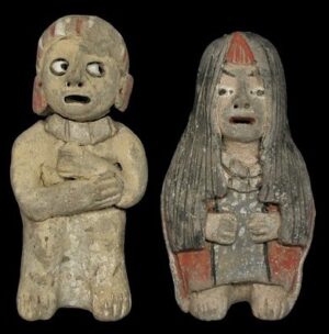
Also found in residences were Quipus, the knotted strings made of camelid fibers such as llama or alpaca wool. Quipus were used, from the Late Archaic or probably earlier, as recording and communication devices arranged on a base ten positional system. Those identified at Caral are among the oldest found in Peru. Furthermore, small low fired ceramic figurines – on average: five high by two inches wide – were found in secular and religious contexts. Their similarity with those of the San Pedro’s phase of the Valdivia culture of Ecuador (2700 BC), is striking. The small Caral figurines are low fired with red and gray colors applied. The arms of the figurines, like those at Valdivia, are usually short and bent toward the chest or placed under the chin. In the Americas, diffusion of ceramics took place over a long span of time and across extensive geographical areas through trade, and some found their replicas at Caral.
* * * * * * * *
The floor plans of residential houses vary according to their proximity to a pyramid complex, a direct reflection of the status of their residents. Their architecture is similar in both upper and lower Caral and, as for collective structures, are built of rocks set with mud. The largest household complex in Caral is found in Sector.A, in the upper half of the city (hanan). The quadrangular houses are built with a main entrance at the front and a door at the back, the later perhaps used for the kitchen or other services. Their sizes vary from 530 to 860 square feet, and they had interconnected rooms, also an indication of the status of a household. In several rooms small platforms and benches (beds?) were found. The walls and floors were covered with white, beige, or light-grey colored plasters, while those with red and yellow paints may indicate that they were the homes of the Caral elite” (Shady, 1997).
* * * * * * * *
The central point still argued today about the diffusion of Peruvian cultures is whether it initiates from the coast, with its bountiful marine resources, or from the Andes Mountains to the Pacific Coast. In the view of archeologists Jonathan Haas and Winifred Creamer, “a complex society arose in Peru, thanks to irrigation agriculture, the same way it did in the world’s five other “pristine” civilizations, Mesopotamia, ca. 3500 BC, Egypt, ca. 3000 BC, India, ca. 2600 BC, China, 1900 BC and Mexico, ca.1200 BC (2005). Historian Karl Wittfogel points out that “irrigation was the catalyst that transformed tribal societies into city-states; for it required forced labor, central planning, a managerial elite, and provided the excess food necessary to support workers and administrators.” (1957). At Caral, the state government was sustained by dynamic diversified crops and a fishing economy. “Its sphere of domination and control included the populations of the Supe, Pativilca and Fortaleza valleys.
However, its connections and prestige extended across the entire north-central Peruvian region” (Shady, 2005). Social groups shared water through five ecological zones. The rivers begin in the high Andean Altiplano and flow through the mountain’s piedmont and, ultimately, to the coastal plains and the Pacific Ocean, a topography that was at the core of Caral’s survival for over a thousand years.
______________________________
Residential Complex @incatrail.com
______________________________
Haas and Creamer raise a pertinent point about “how ancient South Americans made the leap from subsistence fishing to urban sophistication.” Their main argument: “If the exploitation of marine resources is the reason for cultural complexity, why don’t you get a string of these big, complex societies up and down the Pacific coast? You don’t.” Haas maintains that the Late Preceramic sites of Aspero and Banduria, “grew as complex as they did because they could trade with inland settlements that had been revolutionized by irrigation agriculture.”
It takes a complex society to undertake big public construction projects, and the consensus is that complexity sprang from mastering agriculture. Hunter-gatherers had neither the means nor the need to create social hierarchies. That process (which entailed the division of labor and the emergence of a managerial caste), got under way only after humans settled down to farm” (2005). However, Aspero at the mouth of the Supe River, may still reveal surprises since recent radiocarbon dating showed that the village, with its two large platforms and circular sunken courts, had flourished as early as 3033 BC.
The End Time
Caral and its neighboring communities in the Pativilca and Fortaleza valleys were abandoned between 1800 and 1600 BC. Why? We are not sure, but archaeological and geological data point to the relentless onslaught of disrupters and their cumulative effects, which priests could not foresee. Geological data uncovered that an earthquake estimated at 7.2 on the Richter scale took place in about 1820 BC and destroyed much of Caral and Aspero (Sandweiss et all., 2009). This major earthquake was most probably followed by successive tremors of various intensity over the following weeks and months and contributed to more unstable rock and mud slides into the valleys.
The damages may have been worsened by an El Niño event that came concurrently or followed closely the earthquake and its aftershocks. Remains of torrential rains and consecutive gravel and dirt slides from the surrounding hills found by geologists are testimonies to the destruction of agriculture, with the clogging rivers and wells in the valleys. The mouth of the Supe River was heavily choked by sediments that, together with storms, gale force winds and ocean current shifts over months, built up a sand belt along the coast that, to this day, is referred to as the “Middle World.”
____________________________
Banduria, the Middle World @georgefery.com
____________________________
This situation exacerbated an already unstable food supply, for the shift in ocean temperatures with La Niña pushed schools of fish farther and deeper offshore. Worsening an already catastrophic situation were climate shifts and sands blown inland from the coast to agricultural fields in the valleys, further destroying cultures and obstructing canals already damaged by rock and mud slides.
Furthermore, Caral’s neighbors on its north and south were likewise severely impacted by these disastrous events. Food shortage worsened to such an extent that, together with the loss of cotton, produce and fishing, the economy collapsed. The pleas and tears of Caral’s priests could not prevent nor help in such a tragic situation, and Caralinos had no alternative but to flee and seek refuge in less afflicted communities.
The powers of nature were thus harsh on Caral and, so it seems, were its gods and deities. Garcia-Acosta points out that disasters are “triggers and revealers that have been important catalysts of change for much of human history.” As people begin to rebuild their lives in the wake of calamity, “one of their pressing concerns is for closure, for people need to understand why things happened in order to seek ways to make sure it does not happen again” (2002). Under severe conditions, new religious ideas and new leaders often emerge that take cultures in new directions.
____________________________________________
Cover Image, Top Left: Caral Jbenthien, Pixabay
__________________________________
Further Reading:
Ruth Shady Solis, 2001 – The Oldest City in the New World
Jennings, J., 2008 – Catastrophe, Revitalization and Religious Change on the Prehispanic North Coast of Peru
Ruth Shady and Carlos Leyva, 2003 – La Ciudad Sagrado de Caral-Supe
Roxana Hernandez Garcia, 2015 – Caral: 5000 Años de Identidad
Jesús Sánchez Jaén, 2008 – Caral, la Cultura de las Plazas Circulares
Ruth Shady Solis, J. Haas, and W. Creamer, 2001 – Dating Caral, a Preceramic in the Supe Valley on the Central Coast of Peru (Science, 292).
J. Haas and M. Piscitelli, 2004 – The Rise of Andean Pre-Inca Civilizations
Ruth Shady Solis, 2006 – La Civilización Caral: Sistema Social y Manejo del Territorio y sus Recursos; sus Transcendancia en el Proceso Cultural Andino
Eva Jobbova, Ch. Elmke & A. Bevan, 2018 – Ritual Responses to Drought: An Examination of Ritual Expressions
Arthur D. Faram, 2010 – A Geographic Study of the Ancient Caral, Peru
Advertisement
______________________________

Don’t miss out on this unforgettable evening as Dr. Hawass reveals the most closely guarded secrets of ancient Egypt and presents his groundbreaking new discoveries and latest research live on stage. As the man behind all major discoveries in Egypt over the last few decades and director of several ongoing archaeological projects, Dr. Hawass may yet surprise you with unexpected revelations that will make news across the world.
______________________________


