
Editor’s Note: Recent archaeological discoveries have overturned traditional thinking about the capability of ancient humans to navigate the seas, shedding new light on the dispersal of humans prehistorically across the globe. What follows is English maritime writer/historian Bob Hobman’s own narrative of the quest by an organized group of modern seafarers to test the possibilities of ancient seafaring.
As of this writing, eight men and women sailors, keen to exploring what made the world’s first seafarers tick, are readying themselves on Rote Island in eastern Indonesia for a 600 km voyage to cross the Timor Sea on a bamboo raft. They are members of The First Mariners, a global group of people who, by employing the concept of experimental archaeology, are recreating the maritime technology, boats and prehistoric voyages of our hominin ancestors; the world’s first sailors who emerged from the last Homo sapiens dispersal out of Africa some 100,000+ years ago.
Our Middle Pleistocene ancestors were likely not as ‘primitive’ as some scholars suggest. Certainly 70,000 years have seen some changes to human existence, but the oceans have remained mostly unchanged. Granted, glaciation periods have dramatically adjusted sea levels over the millennia, but they had little affect once humans established a harmony with the deep sea.
Approximating Ancient Voyages
In 1985, a seacraft named the ‘Sarimanok’, a 20-meter long double outrigger canoe adzed from a single tree in the Southern Philippines, was constructed to re-enact the migration from Indonesia of human settlers on Madagascar (based on archaeological evidence) some 2,500 years ago (See video below). The canoe sailed from Bali in June, with eight crew and arrived safely on Madagascar seven weeks later. No modern materials were used in the canoe’s construction or sailing rig and the crew survived on what food was available at the time. It was this voyage which inspired the founding of The First Mariners.
______________________________
______________________________
In 2014, stone tools uncovered on Crete – previously thought to have been inhabited for about 12,000 years – were found to be 130,000 years old. The First Mariners set about building an 11-meter raft from thumb diameter stalks of the wild cane arundo donax, harvested on the southern Peloponnese island of Kythira, to follow the trail of the Lower Palaeolithic toolmakers from there to Crete, Greece’s largest island which in human times has always been surrounded by sea. The crew of 10 paddled standing up, with some meager assistance by a propped-up ‘sail’ of split cane, raised whenever a following breeze arose. It took 48 hours to cover the 100 kilometers from Kythira’s southernmost harbor of Kapsali to the old Venetian port of Chania. The original deep sea crossing to Crete would have been only nine kilometers.
________________________________
The cane raft ‘Melida’ and it’s 100 km voyage from Kapsali Bay, the southernmost tip of Kythira Island in the Peloponnese in July, 2014. The experiment was to follow the first inhabitants of Crete. Discovery of stone tools placed them in the Lower Palaeolithic, about 130,000 years ago. Bob Hobman, The First Mariners
________________________________
Flashing back to Indonesia, some 18 years earlier, The First Mariners gathered on the east coast of Bali to film themselves crossing the unpredictable and regularly violent Lombok Strait on a simple bamboo raft tied together with nipa palm fibre rope. This vessel was a cut-down version of the 15-meter bamboo raft which six months earlier had successfully carried a crew of five from Timor to Melville Island off the Australian coast near Darwin.
Why were those Indonesian voyages important?
Academics rarely agree on everything, but most agree that, geologically, Bali/Java – and therefore the great continent of Eurasia — were never joined to the island system and Australia to their east — not since the beginning of humankind. At best the distance to Lombok and then the rest of the islands – including Flores – heading resolutely eastward toward Australia, was 50 kilometers. And that meant, if one were to make the voyage by boat, it was necessary to stage on the little island of Nusa Penida in between.
Anything set afloat on the eastern shore of Bali during the annual Northwest monsoon from April until October is most likely to wash up on Lombok, or Sumbawa, or even further east on the impressively large island of Flores where some scholars suggest that Homo erectus seafarers may have ended up around 840,000 BP years ago. This would have been the hominins’ first ocean crossing. Why they would do this almost a million years ago we may never know, although that does not stop scholars endlessly speculating on whether such a feat was intentional or accidental or something in between. Suffice it to say that humans will go where they want to go, even without a particularly good reason. And they will always find a conveyance to carry them.
The First Mariners repeated the Homo erectus feat on its second attempt. Fourteen paddlers aboard a nine meter long bamboo raft landed on Lombok’s Gili Islands assisted by a roughly woven mat held up to catch whatever there was of a southerly breeze and to help equate the notorious currents which plague the Lombok Strait.
But Homo erectus didn’t seem to maintain this new-found maritime technology. Archaeologically, there is a gap of 800,000 years before the next hominin traces are found in the region — not Homo erectus or Neanderthal — but Homo sapiens, the first representatives of anatomically modern humans. If the dating of stone tools on Crete and Gavdos islands in the Mediterranean is anything near accurate, then humans were already using seacraft by 135,000 years ago. Taking the Greek Islands as an example, humans probably staged their voyages by bridging small gaps along the way with intervisibility: targeting destinations which could be seen.
It is this activity that may have defined the voyage from the islands at the eastern point of the great continent of Eurasia, reached by a wave of nomadic Homo sapiens, to become the last humans to disperse out of Africa and eventually settle Oceania. An estimated 70,000 years ago they could have arrived at the same water barrier – defined now by the Wallace Line*, which demarks the botanical boundary between Asia and Oceania – and repeated what Homo erectus had done to cross it. But they didn’t stop. They kept going, morphing along the way from land nomads into the world’s first islanders and sea nomads.
By at least 65,000 BC, so the latest archaeological clues tell us, they had discovered what is today known as Australia and began colonizing it. By 30,000 BC, according to the archaeological record, they had settled all the islands of Wallacea, the Philippines, and Melanesia of the Western Pacific. With very few exceptions, these locations were all visible to each other. Was Australia (the ancient Sahul Land) included? Could the ancient Sahul continental shelf islands, which were above sea level at the time, provided safe and easily navigable access to the mainland beyond?
It is our hypothesis that these ancient ‘Wallaceans’ – there seems to be no contradicting theory – are the ancestors of the Melanesians and all the indigenous inhabitants of Sahul Land, the vast combined landmass of Papua New Guinea, Australia and Tasmania before the polar ice melted and the sea rose to terrestrially separate them.
The topography has changed since then, and not just a little. For the past 6,000 years the Timor Sea has been up to 600 km wide and its eastern shores not visible from anywhere. At least that’s what we thought. After decades of plodding research into the peopling of Sahul Land, the beginnings of the Australian Aboriginal, academia is suddenly taking an interest in the subject. It is the academic fuel that feeds an experimental archaeological group like The First Mariners, with the result that we are keeping a close eye on what the learned are saying. And the academics are keenly watching what we are doing, as well.
For the past 6,000 years the Timor Sea has been 600 km wide. Before that the gap between the continents of Australia and Eurasia was in places no more than a sixth of that distance, and maybe even much less now that the results of a recent surge of academic interest are coming to light. The traditional consensus is that Sahul Land could not be seen from Asia, that to make a landfall there was either a mistake or the result of an exceedingly bold adventure.
_________________________________
The Sarimanok at sea. It was named after a legendary bird of the Maranao people, who originate from Mindanao, an island in the Philippines. Bob Hobman, The First Mariners
_________________________________
The route of the Sarimanok across the Indian Ocean to Madagascar. Bob Hobman, The First Mariners
_________________________________
From Wallacea to Oceania
The First Mariners team set up its first camp on Rote Island, south of Timor. It was 1998, a year in which the ‘El Nino’ phenomenon with its reverse winds would spell doom for the voyage of the 23-meter bamboo-pontoon raft ‘Nale Tasih I.’ It was El Nino and an infestation of the dreaded ‘bamboo borer’ (Dinoderus minutus). Steadily sinking and unable to make headway against the unseasonal easterly winds, the raft and its 14-strong crew turned back to Rote Island after a mere 48 hours at sea.
The group re-assembled nine months later at the southern tip of Timor to build a smaller ‘Nale Tasih II’. It set out for Australia in front of the northwest monsoon wind in December, 2000, with a crew of four and a seasick, non-swimmer scientist aboard. After six days the 11-meter raft crossed the shallow Australian continental shelf, the ancient border of Sahul Land, and seven days later, 60 nautical miles short of its destination, it was storm driven onto a Melville Island beach.
By bridging the ancient sea gap between the continents, ‘Nale Tasih II’ had technically repeated the crossing to Sahul just as the Wallaceans may have done to become the original Australians.
So why repeat it now with a new venture?
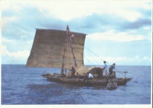
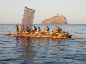
The smaller (11 metres) “Nale Tasih II” succeeded in reaching Melville Island, some 80 kilometres from Darwin. With a crew of five, the voyage took 13 days. Bob Hobman, The First Mariners
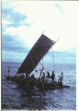
“Nale Tasih II” (pictured right) was only partly representative of the raft the ancients most likely would have used. The rectangular, relatively modern-rigged sail we employed was actually more likely made from nipa palm fibre, woven on Neolithic hand looms by the people of Rote. The raft also was built with metal tools which, according to The First Mariners’ fussy parameters, disqualifies it as a reasonable replication of the craft that is most likely to have made the first crossing of the Timor Sea.
Now we can follow up – with practical application – the speculative voyaging routes which Australian scientists like Michael Bird and Brendan Brooke and the American anthropologist Thomas Whitley of Sonomo State University, Ca. are publishing.
The northern route from Wallacea to Papua New Guinea is challenging the commonly recognized ‘southern route’ from Timor which makes use of a chain of what are now being described as ‘habitable, resource rich’ islands that could have been used as stepping stones for the voyagers when extreme low temperatures enlarged the world’s two ice caps and lowered sea levels, in some parts of the planet a whopping 200 meters.
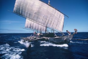
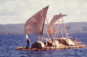
The Nale Tasih III. Bob Hobman, The First Mariners
The new raft will comply with all the unwritten rules of Middle Pleistocene maritime technology. A Dutch master stone tool expert is already fashioning a full assemblage of the era’s stone tools. Two local botanists will ensure that gathering food for the crossing will follow strict principles and the raft’s unsophisticated sail will be layers of the great fan-like fronds of the Borassus flabellifer sugar palm, a native of the Indian sub-continent but which could well have been around at the time of the first voyages.
The crew’s basic diet will be fish baked over a coral hearth fire ignited by various techniques learned on the earlier voyages. The banana is thought to have originated in neighboring Papua New Guinea. Bamboo shoots will be shredded to provide vegetable material and so will the tops of coconut palms. Fish of all descriptions are readily speared as they seek relief from the sun’s blazing noon zenith beneath the wide and slow-moving raft. Without ceramic pots it is also possible to boil water in a leak-proof lontar palm basket the locals call haik and the raft will carry a large supply of mature coconuts for the nut’s water and flesh and its outer shell to feed the fire. Birds’ eggs are allowed, and honey. Drinking water from the region’s annual west monsoon rain squalls will be trapped in bamboo tubes.
With the following northwest monsoon wind the voyage could take less than two weeks. As it was for the original journey, there will be no pre-established landfall, although Darwin of course would be a convenient one since much of Australia’s mostly uninhabited northwest coastline offers an unwelcome shore to vessels of any ilk.
It will not be a drift voyage. Nor will it be a sailing venture, but something in between. The raft’s crew will have paddles but also a great pile of palm leaves. As the first human conquerors of the Timor Sea would have done, some kind of basic sail must have been employed. Humans are notoriously adept at exploiting nature to ease their burden. The First Mariners believe that even the earliest hominins were not stupid or suicidal enough to treat the oceans and enclosed seas like the Mediterranean with anything but caution and a great deal of respect. Their early craft would have been devised to reach pelagic and deep water fish.**
________________________________
The 19-metrer-long “Nale Tasih I” under full sail and clearly sinking. Bamboo wrongly harvested at the waning stage of the moon allowed access to the ravaging dreaded ‘Powderpost Beetle’ which caused flooding of the culms. Combined with adverse winds, the voyage from Rote Island to northern Australia was abandoned after 48 hours. Bob Hobman, The First Mariners
________________________________
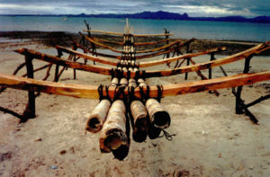
A bamboo raft is born. Construction begins on the raft ‘Nale Tasih II’ at the dark of the moon’s high tide mark on a beach near Kupang on Indonesia’s most eastern island of Timor. The raft’s body will be finished by the high tide of the full moon two weeks later and can be floated without damaging the bark rope lashings underneath. Bob Hobman, The First Mariners
________________________________
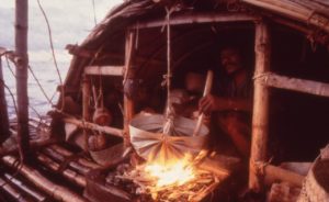
The first two ’Nale Tasih’ rafts employed an ancient, pre-ceramic local cooking technique. The ends of a ‘lontar’ palm leaf are squeezed together and secured to a transverse stick to make an instant, watertight basket which, suspended over heated coals will cook foxtail millet, tubers or rice. It resists burning as long as there is water inside. Bob Hobman, The First Mariners
________________________________
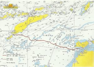
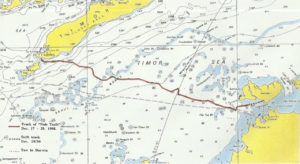
The route of “Nale Tasih II.” Rigged with a hand woven palm-fibre sail and pushed by the seasonal Northwest monsoon, the raft averaged a little over 1.5 knots. Bob Hobman, The First Mariners
________________________________
Our Homo sapiens ancestors have been nothing if not experimental, and humans with their renowned persistence found a way to — not control the ocean or master it — but come to terms with it very well over the past 100,000 years or more. Some more than others, but some not at all, like Australia’s first colonists who, while still part of the world’s most ancient living culture, seem to have turned their backs to the sea in time to become super-terrestrials, wiping out the continent’s megafauna in record time while not producing any notable examples of maritime technology during their 65,000-year-long tenure.
But that is not something for The First Mariners to ponder. Perhaps at a later time. For now, our mandate is to get the settlers to that broad island continent we today call Australia.
To learn more about The First Mariners, readers can go to their website at https://www.thefirstmarinersexpeditions.com/
*Wallace’s Line delineates Australian and Southeast Asian fauna. The deep water of the Lombok Strait between Bali and Lombok formed a water barrier even when lower sea levels linked the now-separated islands and landmasses on either side anciently. (Wikipedia)
**This Timor Sea crossing is currently planned to take place in February, 2020.
If you liked this article, you may like the premium article, Thor Heyerdahl and the Theory of the Archaeological Raft.
________________________________
See the original fossils and artifacts, see the actual sites, and talk with the famous scientists on this unique and specialized study tour.


