

UNIVERSITY COLLEGE LONDON—Human bipedalism – walking upright on two legs – may have evolved in trees, and not on the ground as previously thought, according to a new study involving UCL researchers.
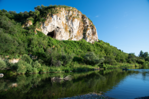
In the study, published today in the journal Science Advances, researchers from UCL, the University of Kent, and Duke University, USA, explored the behaviors of wild chimpanzees – our closest living relative – living in the Issa Valley of western Tanzania, within the region of the East African Rift Valley. Known as ‘savanna-mosaic’ – a mix of dry open land with few trees and patches of dense forest – the chimpanzees’ habitat is very similar to that of our earliest human ancestors and was chosen to enable the scientists to explore whether the openness of this type of landscape could have encouraged bipedalism in hominins.
The study is the first of its kind to explore if savanna-mosaic habitats would account for increased time spent on the ground by the Issa chimpanzees, and compares their behavior to other studies on their solely forest-dwelling cousins in other parts of Africa.
Overall, the study found that the Issa chimpanzees spent as much time in the trees as other chimpanzees living in dense forests, despite their more open habitat, and were not more terrestrial (land-based) as expected.
Furthermore, although the researchers expected the Issa chimpanzees to walk upright more in open savanna vegetation, where they cannot easily travel via the tree canopy, more than 85% of occurrences of bipedalism took place in the trees.
The authors say that their findings contradict widely accepted theories that suggest that it was an open, dry savanna environment that encouraged our prehistoric human relatives to walk upright – and instead suggests that they may have evolved to walk on two feet to move around the trees.
Study co-author Dr Alex Piel (UCL Anthropology) said: “We naturally assumed that because Issa has fewer trees than typical tropical forests, where most chimpanzees live, we would see individuals more often on the ground than in the trees. Moreover, because so many of the traditional drivers of bipedalism (such as carrying objects or seeing over tall grass, for example) are associated with being on the ground, we thought we’d naturally see more bipedalism here as well. However, this is not what we found.
“Our study suggests that the retreat of forests in the late Miocene-Pliocene era around five million years ago and the more open savanna habitats were in fact not a catalyst for the evolution of bipedalism. Instead, trees probably remained essential to its evolution – with the search for food-producing trees a likely driver of this trait.”
_______________________________

_______________________________
To establish their findings, the researchers recorded more than 13,700 instantaneous observations of positional behavior from 13 chimpanzee adults (six females and seven males), including almost 2,850 observations of individual locomotor events (e.g., climbing, walking, hanging, etc.), over the course of the 15-month study. They then used the relationship between tree/land-based behavior and vegetation (forest vs woodland) to investigate patterns of association. Similarly, they noted each instance of bipedalism and whether it was associated with being on the ground or in the trees.
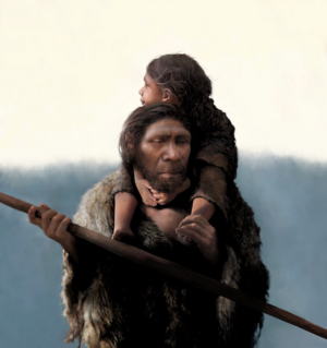
The authors note that walking on two feet is a defining feature of humans when compared to other great apes, who “knuckle walk”. Yet, despite their study, researchers say why humans alone amongst the apes first began to walk on two feet still remains a mystery.
Study co-author Dr Fiona Stewart (UCL Anthropology) said: “To date, the numerous hypotheses for the evolution of bipedalism share the idea that hominins (human ancestors) came down from the trees and walked upright on the ground, especially in more arid, open habitats that lacked tree cover. Our data do not support that at all.
“Unfortunately, the traditional idea of fewer trees equals more terrestriality (land dwelling) just isn’t borne out with the Issa data. What we need to focus on now is how and why these chimpanzees spend so much time in the trees – and that is what we’ll focus on next on our way to piecing together this complex evolutionary puzzle.”
_________________________________
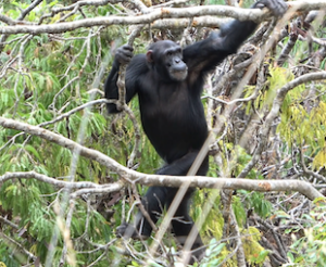
An adult male chimpanzee walks upright to navigate flexible branches in the open canopy, characteristic of the Issa Valley savanna-mosaic habitat.Despite their open and dry habitat, chimpanzees at Issa remained highly arboreal and did not walk on the ground more than chimpanzees living in tropical forest, findings which support upright walking evolving in the trees, not on the ground in our early ancestors Rhiana Drummond-Clarke
_________________________________
Article Source: University College London news releas
*Wild chimpanzee behavior suggests that a savanna-mosaic habitat did not support the emergence of hominin terrestrial bipedalism, Science Advances, 14-Dec-2022. 10.1126/sciadv.add9752
_________________________________
Advertisement
_________________________________

Don’t miss out on this unforgettable evening as Dr. Hawass reveals the most closely guarded secrets of ancient Egypt and presents his groundbreaking new discoveries and latest research live on stage. As the man behind all major discoveries in Egypt over the last few decades and director of several ongoing archaeological projects, Dr. Hawass may yet surprise you with unexpected revelations that will make news across the world.
_________________________________
Advertisement


,_1st_cent._CE,_Saudi_Arabia_(8).jpg)