

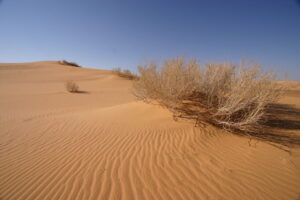
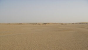
To traverse across this land for more than 30 minutes, anyone would need a good hat, sturdy shoes, eye shades, a good dose of sun block lotion, and an ample portable supply of fresh water. Those are just the basics. Anything more depends on your planned time, distance and activity.
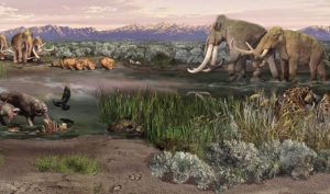
This is, as was once also popularly described about the lunar surface, a magnificent desolation. The Great Nefud Desert spreads as an expansive oval shaped region across northern Saudi Arabia for about 70,000 square kilometers, characterized by rocky elevations of rock and sand ranging from 600 to 1,000 meters. Its face moves with shifting red sands, lifted by perpetual strong winds. Isolated red sandstone massifs pockmark the terrain, sculpted by tens of thousands of years of wind action, creating in some places an almost surreal landscape with an otherworldly feel. Summer temperatures can typically range between 30 to 54 degrees Celsius (between 85 and 120 degrees Fahrenheit). It goes without saying that vegetation is sparse, though a significant presence of ephemeral plants can be seen during ‘wet’ years. Despite the desolation here, modest communities of hyenas, jackals, wildcats, ungulates like gazelle, rodents and lizards make it their domicile.
___________________________________
___________________________________
Today, humans live here, too. Concentrated primarily in lowland areas such as near the Hejaz Mountains, they manage and inhabit oases where dates, vegetables, barley, and fruits are grown. Indeed, an entire city of about 20,000 people —Jubbah — is completely surrounded by the Nefud. Thus in modern times, people have learned how to live and even thrive in this desert.
___________________________________
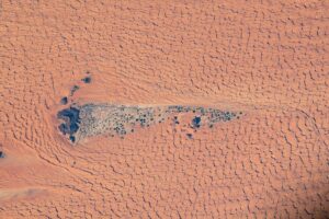
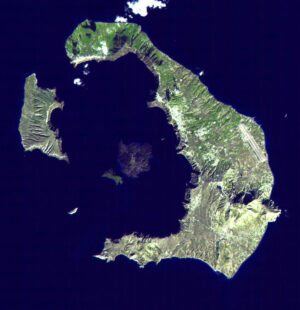
Jubba as viewed from space. Public Domain, Wikimeda Commons
___________________________________
Following The Water
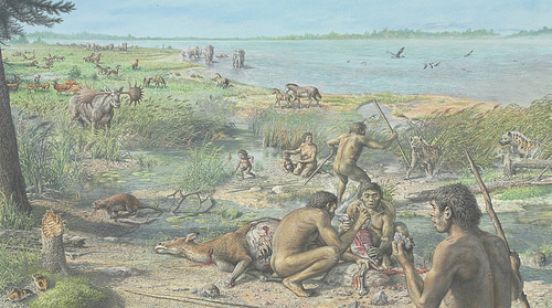
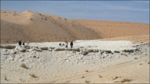
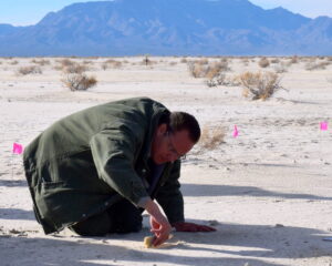
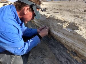
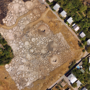
The Nefud was not always like this. In recent years, teams of scientists have walked and camped across the region, surveying, sampling, excavating, studying and documenting sites that today present evidence of ancient lakes — in geologic parlance, lacustrine deposits — of which many date back at least several hundred thousand years. One can see the remnants of these ancient lakes by walking across the surface, and especially by viewing the surface from aerial vantage points. They have a different color and consistency from what is often a context of windblown, sandy dunes. In these places, scientists have uncovered fossils and other evidence of water-endowed spaces that, tens of thousands of years ago, were frequented or inhabited by a variety of animal and plant species — ecosystems much like the savannas of Africa we see today. By analyzing the recovered fossils, climate models and records, and the lacustrine sediment records of these ancient lake remnants, scientists have discovered that, at wetter intervals in this desert environment’s arid past, ‘greener’ conditions afforded a critical accommodation for fluctuating communities of life.
The site of Ti’s al Ghadah in southwestern Nefud presents a perfect example of this. This site is located within an internal depression, or basin. As a 630-meter area ancient paleo-lake deposit outcrop, it has been dated to Pleistocene times and contains a rich array of fossil fauna.
““Ti’s al Ghadah is one of the most important palaeontological sites in the Arabian Peninsula and it currently represents the only dated collection of middle Pleistocene fossil animals in this part of the world, and includes animals such as elephant, jaguar and water birds,” says Mathew Stewart of the University of South Wales, lead author of a 2019 published study/paper* on the results of taphonomic and zooarchaeological investigations at the site.** Most notably, the paper documented the discovery of stone tools spatially associated with evidence of butchery of animals dated to between 500,000 and 300,000 years ago.
The implications were enormous. There were humans here — or, more accurately, hominins —even before the emergence of our own species, Homo sapiens. Said Michael Petraglia, the Ti’s al Ghadah project principal archaeologist and paper co-author, “This makes Ti’s al Ghadah the first, early hominin-associated fossil assemblage from the Arabian Peninsula, demonstrating that our ancestors were exploiting a variety of animals as they wandered into the green interior.”**
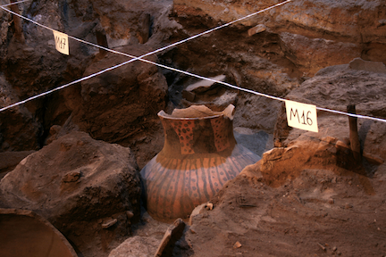
__________________________________
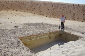
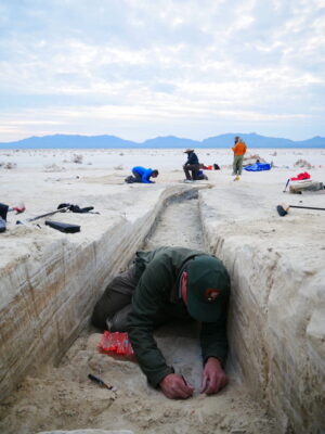
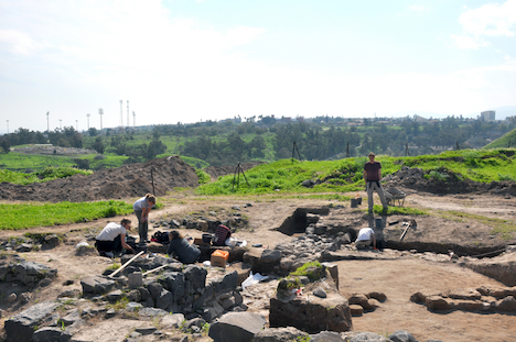
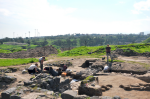
A trench at the site of Ti’s al Ghaddah, where a large collection of animal fossils dating to approximately 500,000 years ago have been found. Photo: Palaeodeserts Project, from One Small Arabian Fingerbone, by Huw S. Groucutt, Popular Archaeology July 7, 2018.
__________________________________
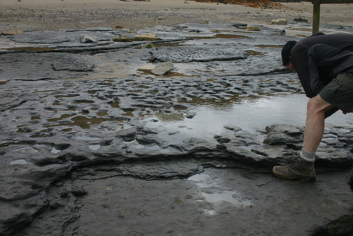
Who were these hominins? If not Homo sapiens, then what species? Scientists don’t know the answer to this question, but researchers have discovered other sites that have demonstrated a hominin presence in Arabia. An Nasim, a paleo-lake site in an internal basin like Ti’s al Ghadah within the Nefud, was found to contain Acheulean-type stone tools, along with other fossil fauna, dated to between 350 and 250 ka (thousand years) ago. And the list of new artifact discoveries at similar sites continues to expand, including a remarkable recent discovery at another paleo-lake site in the Nefud known as Al Wusta in 2016………
Bone
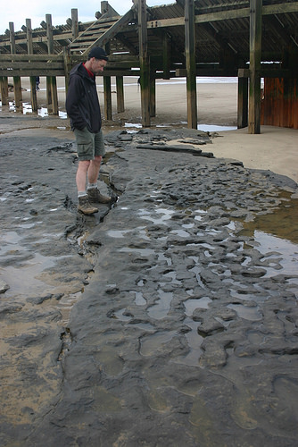
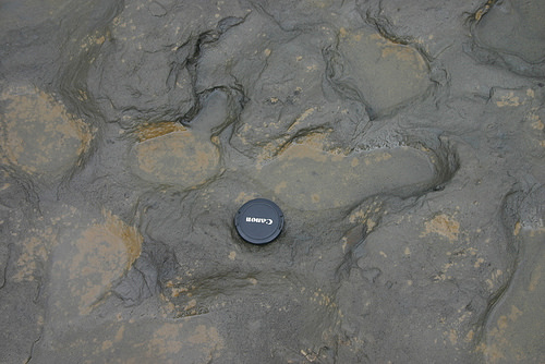
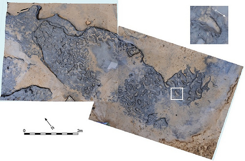
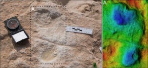
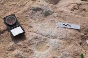
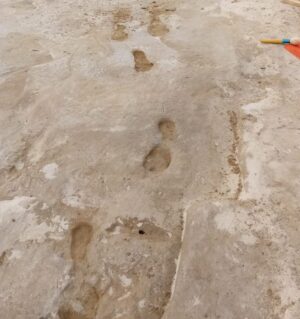
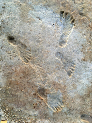
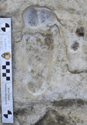
The evidence for hominin occupation around the ancient paleo-lakes of Arabia has been evidenced primarily through stone tool artifact finds, including some proof of usage for processing animals at sites like Ti’s al Ghadah and the discovery of hominin footprints at the Alathar ancient paleolake deposit located within the western Nefud****. But Huw Groucutt, an archaeologist at the University of Oxford who has played a key role in the ongoing research on early humans in the Arabian Peninsula, tells the story of a tantalizing discovery made while investigating sites in the Nefud region:
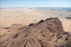
“We made a quick visit to Al Wusta in 2014, which involved driving down steep dunes to the base of an inter-dunal depression. We noted some stone tools and interesting sediments, but it was late in the day and the sun was getting low in the sky so we did not stay long. It was clearly an interesting site, but we located dozens of interesting sites. It was a place to which we wanted to return at some point, and our team member Prof Nick Drake (Kings College London) kept mentioning the site as something that looked significant. In 2016 we returned to the site with a large interdisciplinary team of international and Saudi scholars. We walked to the far end of the site where we had not previously been, and immediately found numerous animal bones and human-made stone tools on the surface. These were scattered around deposits of lake sediments. Then our colleague, Dr Iyad Zalmout from the Saudi Geological Survey, picked up a small and well preserved fossil.” ***
The find turned out to be a human intermediate phalanx (middle finger bone, the bone from the knuckle toward the end of the finger). By employing a series of chronometric dating techniques, scientists were able to determine the age to be between 95-86 thousand years old.
That made this find rare and remarkable, as it represented the only direct fossil evidence ever found of human habitation in the region as long ago as nearly 90,000 years BP.
__________________________________
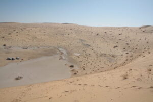
The Al Wusta site from the top of a neighboring sand dune. Photo: Ian Candy. From One Small Arabian Fingerbone, by Huw S. Groucutt, Popular Archaeology July 7, 2018.
__________________________________
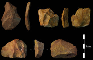
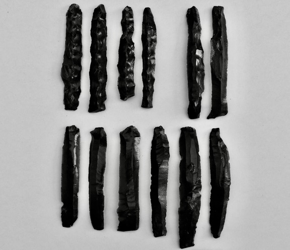
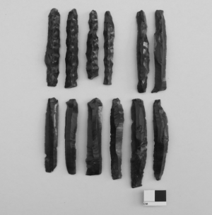
Lithic artifacts (stone tools) from Al Wusta. Top row: two Levallois flakes, bottom: Levallois core. Photo: Eleanor Scerri. From One Small Arabian Fingerbone, by Huw S. Groucutt, Popular Archaeology July 7, 2018.
__________________________________
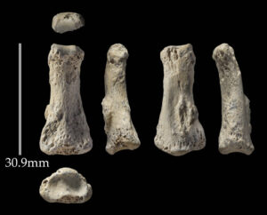
The Al-Wusta 1 intermediate phalanx fingerbone. Photo: Ian R. Cartwright. From One Small Arabian Fingerbone, by Huw S. Groucutt, Popular Archaeology July 7, 2018.
__________________________________
What kind of human?
So the phalanx was human, but to what species of human did it belong? Given the age, could it be Neanderthal?
“In many cases, a single fossil would not be enough to determine the species represented,” says Groucutt. “In the case of the finger bone, however, we are lucky in that this bone is very different in Neanderthals and Homo sapiens. In basic terms, Neanderthal intermediate phalanges are relatively shorter and are generally more robust, while those of Homo sapiens are relatively longer and are more gracile. The [measurement] values for the Al Wusta finger bone clearly aligns it with Homo sapiens.”**
Combined with the associated lithics, the case then became a slam-dunk for early modern humans. Many of the Al Wusta site artifacts “feature an emphasis on centripetal Levallois technology”, says Groucutt. This is a manufacturing technique typical of Middle Paleolithic/Middle Stone Age period stone tools, common among finds associated with the early modern human presence at other sites, such as in east and north Africa.
Dispersal into Green Arabia
Luminescence dating of the sediments at these paleo-lake deposit sites indicates that the dates for the evidence of hominin occupation occurred at a time of higher rainfall in the region, when freshwater lakes, wetlands and rivers formed, inviting development of migration routes for animal species……. and hominins.
“It’s remarkable; every time it was wet, people were there,” says Petraglia from the Max Planck Institute for the Science of Human History. “This work puts Arabia on the global map for human prehistory.”***** As more evidence of hominin occupation in the region mounts, scientists are becoming increasingly convinced that the Arabian Peninsula was an important corridor for dispersal of hominins out of Africa into the rest of the world, occurring in different waves and at different times in prehistory.
And the findings portend the development of a broader and more complex story on human evolution. “Arabia has long been seen as empty throughout the past,” says Groucutt. “Our work shows that we still know so little about human evolution in vast areas of the world and highlights the fact that many surprises are still out there.”*****
Early Desert Monuments
Most archaeologists would say that the Neolithic, a time period between 10,000–4,500 BCE, was best characterized by the beginnings of agriculture and fixed human settlements. These people were not known for their massive architectural achievements and monuments. But a recent excavation led by a team of archaeologists from the University of Western Australia has shed new light on ancient monumental structures dating back over 7,000 years ago, located in present-day Saudi Arabia.
Known as “mustatils,” named after the Arabic word for rectangle, these structures have been the subject of very little research, despite the fact that they are not a recent discovery.
“We started excavating in 2019 as it was the natural progression of our work in the region,” explains Dr. Melissa Kennedy, one of six researchers working on this excavation. “Once we had found out how these structures were formed it was important to be able to date them.”
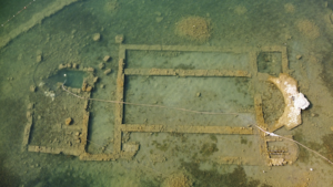
The team documented hundreds of mustatils aerially, explored almost 40 on the ground, and excavated one, making this the largest study ever conducted on these structures. According to the project’s director Dr. Hugh Thomas, in an interview for Antiquity, over 1,000 mustatils were documented during this project, covering over 200,000 km2 in northwest Arabia.
Dr. Kennedy notes, “Our project started off as purely aerial photography and after viewing our photos of these structures we began to realize that these features were extraordinarily well preserved and that we needed to visit them on the ground. That is when we really began to realize how complex these structures were. Having the aerial photography component of our project is unique, as this allows us to get a different perspective on the archaeological remains we are documenting.”
“We use a variety of techniques; remote sensing, using publicly available satellite imagery, aerial photography, ground survey, and traditional excavation,” she explains. “We also used a lot of digital technologies, such as orthophotography, which is a highly accurate photo mosaic created from hundreds of aerial photographs, and drones. The main challenge with this site is that the structure was made of a type of stone that was highly degraded. It made work in the head of the structure very difficult and very hard to define the chamber.”
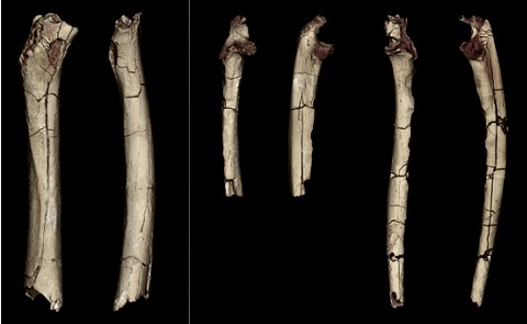
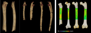
This research has more than doubled the total known number of mustatils in Saudi Arabia and established that these structures were far more architecturally complex than previously supposed. Cattle horns and skull parts were uncovered at the site as apparent offerings, confirming assumptions that the structures were built for rituals. Cattle was a vital part of the lives of early humans in the region. Evidence of ‘cattle cults’ have been found in southern Arabia around 900 years later, making it reasonable to conclude that these more ancient mustatils may have been an early example of these cults.
The number and consistency of mustatils in northwest Arabia suggests to researchers that these beliefs were widespread across the region. Given their size and number, they were likely large groups of people coming together and organizing to erect these ritual sites, creating the oldest monumental landscape of this scale ever identified, predating the pyramids of Egypt and Stonehenge in Britain.
“We hope to gain a broader insight into the cultic landscape of northwest Arabia in the late Neolithic,” says Dr. Kennedy. “Particularly, why were these large cultic structures built, what were the beliefs of these people and why did this tradition die out?”
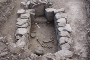
While the findings of the excavation shed light on the ritual traditions and community organization of this region, they also offer more information on the wildlife at the time. Dr. Kennedy explains, “The animal horns are extraordinarily well preserved; they are very important as they give us an insight into the type of cattle being herded in the region in a way that the bones do not.”
“From our perspective, the most significant finds from our work have been from the mustatil and the collective burial we excavated that featured the earliest domestic dog in Arabia,” notes Dr. Kennedy. “For the mustatil, articulating the different facets of these structures has been very important. With the collective burial, we identified multiple phases of use and significant animal offerings. This is some of the earliest evidence for this in northwest Arabia.”
_________________________________
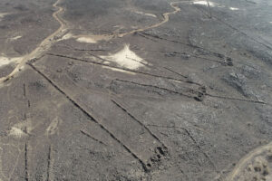
A group of three mustatils. AAKSAU and Royal Commission for AIUIa. From Before Stonehenge: Monument Builders of Arabia, by Arianna Zakrzewski , Popular Archaeology, July 6, 2021
_________________________________
Mustatils from the Harrat Kaybar, Saudi Arabia. AAKSAU and Royal Commission for AIUIAa. From Before Stonehenge: Monument Builders of Arabia, by Arianna Zakrzewski , Popular Archaeology, July 6, 2021
_________________________________
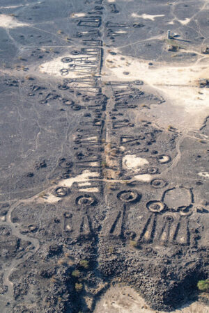
Mustatils are not the only early stone structures that have recently been discovered on the Arabian landscape. Dated as far back as the Late Neolithic, monumental structures now penned as “desert kites” have been photographed, surveyed and examined across the landscape in southern Jordan and northwest Saudi Arabia. Although 700 to 800 of these surface formations were known to exist 20 years ago, investigators now account for at least 6,500 and counting. They are described as ‘kites’ because, when viewed from above, many of them resemble the shapes of children’s kites with streamers that were popular on the market years ago. According to researchers’ interpretations as documented in recently published study reports******, these structures were actually massive traps constructed by Neolithic and early Bronze Age people to methodically lead or force their animal prey to natural precipices or human-made pits where they would fall to their deaths.
“Regardless of form,” states an October 24, 2022 press release from HK Strategies and the Royal Commission for ALULa****** “all kites in the region have driving lines of low stone walls that converge to funnel animals towards a trap such as a pit or precipice. On average, the driving lines of the AlUla kites are approximately 200m long. However, elsewhere they can stretch for kilometres.”
“While kites recorded in the AlUla region [in northwest Saudi Arabia] tended to funnel prey towards a sudden precipice,” continues the press release, “kites elsewhere often end in concealed pits, in which hundreds of animals could be killed during a single hunt.”******
______________________________________
A kite in Khaybar. These ancient hunting traps were named ‘kites’ by aviators in the 1920s because, from above, they resemble old-fashioned children’s kites. (Diaa Albukaai and Kévin Guadagnini, Khaybar Longue Durée Archaeological Project/RCU/Afalula/CNRS)
______________________________________
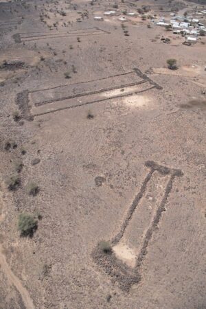
In other research, archaeologists of the University of Western Australia (UWA), reporting findings in the journal The Holocene in January, 2022, suggest that people who lived in ancient north-west Arabia built long-distance ‘funerary avenues’ – major pathways flanked by thousands of burial monuments that linked oases and pastures.*******
“The existence of the funerary avenues suggests that complex social horizons existed 4,500 years ago across a huge swathe of the Arabian Peninsula,” states the press release.*******
The researchers applied satellite imagery analysis and aerial photography, and then ground survey work and excavations to further identify and study the funerary avenues over at least 160,000 square km, recording more than 17,800 ‘pendant’-shaped tombs in the AlUla and Khaybar areas. They found that the highest numbers of funerary avenues were located near water resources, and appeared to be created for travel between oases. Others appeared to have been used for moving domestic animal herds into pasture areas during periods of rain.
__________________________________________
Pendant tombs and funerary avenues discovered in north-west Saudi Arabia. Courtesy Royal Commission for AlUla.
__________________________________________
Ancient Civilizations of the Incense Road
Few activities spurred the creation of great ancient cities more than the Incense Trade Route, otherwise known as the Incense Road. It was a far-reaching ancient trade network linking the Mediterranean world with eastern and southern producers of incense, spices and other luxury goods, ending at Mediterranean ports in the Levant and Egypt, Northeast Africa, Arabia and India. It powered the magnificent rise and florescence of monumental civilizations on the Arabian Peninsula, which reached their height between the 7th century BC and the 2nd century AD.
One archaeologist in particular was inspired to explore the hidden secret of these monumental cities during the 1950’s and 60’s………….
Saba’s Desert Jewel
No other ancient site in Yemen, a country that skirts the southern coast of Arabian Peninsula, excited Wendell Phillips more than the prospect of excavating at Ma’rib, the capital of the ancient Sabaeans (people of the Kingdom of Saba) and thought by many biblical scholars as the likely residence of the famed 10th century Queen of Sheba. As an American adventurer and archaeologist, it was among his plans from the beginning to explore the possibility of obtaining permission to excavate at the site, but the area was regarded as forbidden to Westerners because of tribal unrest. Approval and support from Imam Ahmed, the King of Yemen, however, could make all the difference, and this is exactly what Phillips attempted to obtain. An audience with the King was finally realized, resulting in approval for Phillips and his team to push forward to Marib for this, the first excavation by a Western expedition to Ma’rib in over 60 years. Efforts began in earnest during the 1950’s.
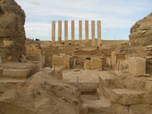
Getting to Ma’rib required an uneasy journey northward across the dunes through what for Westerners was largely unexplored land. But once there, Phillips was overwhelmed by the site. Phillips knew that local Yemenis had already dug about 70 feet down at one point at the site to recover stone blocks for a fortress and houses, encountering cultural layers as they went. But he knew that excavating the entire city would be far too much to tackle at this point, so the team focused their efforts on what was clearly the most prominently visible feature of the city—the Mahram Bilqis, or Temple of Awam, otherwise known by the ancients as the Temple of Almaqah, dedicated to the moon god who was the principal deity of Ma’rib.
Only the tops of eight massive pillars and the upper part of an oval-shaped wall could be seen jutting above the windblown sand at first, but as they dug, painstakingly removing tons of sand and soil with a workforce of scores of workmen, they eventually uncovered a large hall with monumental pillars, stairways, inscriptions, and bronze and alabaster sculptures. In some places the wall of the temple itself, 13.5 feet thick and constructed of fitted ashlar masonry, still stood to a height of more than 27 feet above the temple’s excavated entrance hall. Adjacent to the temple they uncovered evidence of a mausoleum and tombs similar to what they had previously unearthed at the ancient site of Timna to the north.
These discoveries were already magnificent by any measure, and there was potentially much more to unearth. But developing tribal tensions spelled danger for the team long before they could achieve their objectives, and they were forced to leave the site, never to return as an expedition under Phillips’ direction again. Their sudden, hasty exit meant leaving their equipment and archaeological discoveries behind, though their written records were later published in scholarly reports. Phillips died in 1975, never having realized his hopes of returning to Ma’rib to finish the work.
Return to Ma’rib
It wasn’t until 1998, more than two decades later, when renewed excavations began at Ma’rib. Invited by the government of Yemen to resume excavations where her brother left off in 1952, Merilyn Phillips Hodgson took the ball and ran with it. With more than fifty workmen and an international team that included archaeologists, epigraphists, architects, and other specialists involved in what turned out to be a multi-year expedition lasting nine seasons, their discoveries were no less sensational than those made decades earlier. Focusing on the Awam Temple, hundreds of new inscriptions were recovered, and for the first time, the interior of the oval precinct walls of the complex was uncovered to a depth of sixteen feet. Features of its main Peristyle Hall and Annex areas were uncovered and defined, and more insight to the construction and occupational chronology or sequence for the Temple was acquired.
“The earliest material cultural remains excavated in the Awam complex date to the eighth century BC,” wrote archaeologists Zaydoon Zaid and Mohammed Maraqten in a report of their findings from the Temple complex. “Inscriptions mark the beginning of the history of occupation of the site.” Add to this “a recently discovered but as yet unpublished inscribed block that served as the base of a statue mentions a dedication by the Shab of Saba and is dated according to the Himyaritic era (i.e. 115 or 110 BC) to the late fourth century AD. It confirms the continuity of the main function of the temple as a sacred place……..The architectural sequence for the Awam temple would therefore seem to span a period from the first millennium BC to the late fourth century AD.”********
The results of the renewed excavations further confirmed what Phillips had, decades before, concluded about the significance of the site. In terms of the construction date chronology, continuity of use, opulence and monumental scale, the Awam Temple was, according to Zaid, clearly “one of the most important monuments of the Sabaean period, which doubtless composed the religious center of the city of Ma’rib and of ancient South Arabia as a whole”.******** It bespoke a civilization that, in its time, rivaled the great civilizations to its north, west and east, for it was in Ma’rib that the Sabaean kings made their capital, building massive irrigation works such as the Ma’rib dams, (the ruins of which are still visible) and other monumental buildings, made possible by the wealth brought in through the incense trade routes and extensive maritime connections as a seafaring people. It was a flourishing culture for more than a thousand years.
Was it here, at the Awam Temple, that the biblical Queen of Sheba worshipped? As far as scholars know, the temple construction chronology post-dates the time period in which many biblical scholars suggest she lived, the 10th century BCE. Was there an earlier temple on this spot? Further excavation may shed additional light on the question. “One of our main objectives is to continue excavating inside the Oval areal, where we think we will find a lot of answers that will help to establish and complete the occupational history of the site,” says Zaid.
Zaid hopes to one day return to finish where the last set of seasons left off, but the political situation and unrest mitigates the possibilities.
He tempers some sadness with wishful anticipation. “Yemen is a unique land, something like an open museum,” he says. “When you travel in Yemen, talk to the kind Yemeni people, visit the old cities and the amazing bazaars—you would think that time has stopped. Things are still much the same as they were hundreds of years ago. We hope that the situation in Yemen will develop in a positive way, so that the people of Yemen will have their peace and go back to normal life and, of course, allow us to go back to continue our work at the temple.”
Phillips, no doubt, if he were alive, would be in the front of the pack.
__________________________________
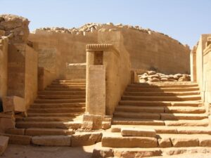
View of the impressive excavated staircase in ‘Area A’ of the Awam Temple at Ma’rib. Excavations have revealed that the Temple Complex includes several major architectural components: The Oval Wall, enclosing most of an open-air Oval Precinct; The Peristyle Hall with thirty-two pillars surrounding a large courtyard; The Annex Area along the north-east side of the Peristyle Hall and parallel to the eight monumental pillars; A large courtyard area, Area A, building 1, paved passage and staircases; A mausoleum adjacent to the south-east exterior of the Oval Wall; and a cemetery to the south-west of the Oval Wall. Courtesy Zaydoon Zaid and the AFSM. From The Real Indy, Popular Archaeology, December 20, 2014
__________________________________
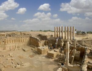
View of the excavated Peristyle Hall and Annex area at Ma’rib. Courtesy Zaydoon Zaid and the AFSM. From The Real Indy, Popular Archaeology, December 20, 2014
__________________________________
The Temple pillars as seen from inside the Oval Wall at Ma’rib. Courtesy Zaydoon Zaid and the AFSM. From The Real Indy, Popular Archaeology, December 20, 2014
__________________________________
The Treasures of AlUla
Located about 190 miles north of Medina in northwest Saudi Arabia, the city of AlUla, set within a valley oasis of palms and citrus groves, comprises a population of just over 5400 residents. Though relatively small in terms of population and infrastructure, this place has nonetheless been the focus of national attention by the country’s government to expand and develop its historical, cultural, and natural attractions with the goal of making it a super-magnet for international tourism. There is good reason for this. The AlUla region is richly endowed with archaeological sites that date back to the Bronze Age, but most prolifically through the first millennium BC into the early centuries AD, when Arabian spices and other goods were traded up along the routes of the Incense Road, enriching the ‘middle men’ cites and oases along its route and giving rise to wealthy and monumental communities.
“Already, well over 100 archaeologists are working across AlUla during fieldwork seasons and projects, shedding light on many past eras and revealing the depth and richness of AlUla’s cultural heritage,” says Dr Abdulrahman Alsuhaibani, Acting Executive Director of Collections at the Royal Commission for AlUla (RCU) and associate professor of archaeology at King Saud University.*******. “Our teams [have been] uncovering more than 10,000 artifacts per year. Our storage units are growing rich with wonderful finds – from the minute (for example, a unique leaf-shaped mother-of-pearl pendant found in a burial site dating to between 4300 and 3500 BCE) to the monumental (2.5m-tall statues of broad-shouldered kings excavated at Dedan dated to between the 5th and 3rd centuries BCE).”******* Simultaneously, resources are being mobilized to ensure the safe preservation, conservation and storage of the treasures they uncover, as well as the treasures that have already been unearthed and exhibited to the world. Facilities are already slated to be built that will showcase this cultural heritage and house the institutions established to administer the projects and promote AlUla as a major world cultural attraction for tourism. Toward this end, Alsuhaibani and his colleagues plan to “work with the best cultural institutions and businesses, large or small, around the world to place RCU and the Kingdom of Saudi Arabia at the forefront of the community.”*******
Since 2005, Alsuhaibani himself has excavated at sites that are revealing more evidence of the ancient kingdoms of Dadan and Lihyan. Beginning around 600 years BC, a capital city built and ruled by a succession of dynastic kings arose in UlUla, The oasis supported agriculture and herding, the city’s economic foundation, but the movement of precious commodities of trade from southern Arabia — products like frankincense, resin, and other aromatics — stopped here to be further transported to distant locations in the Mediterranean. The ‘middle-men’ businesses that profited from this activity enriched the Dadanites, and the successive dynasties of the Lihyanites.
____________________________________
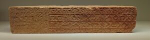
A Dadanite inscription. Zunkir, (CC BY-SA 4.0), Wikimedia Commons
____________________________________
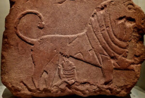
Dadanite bas relief of a lion. Sanctuaire de Dadan (al-Khuraybah), al-‘Ula. Daté des Ve-Ier siècles av. J.-C. Sur bloc de grès rouge. Présenté à l’Institut du Monde Arabe de Paris pour l’exposition sur Al-‘Ula, prêt du Musée du département d’archéologie de Riyad, université du roi Saud. Zunkir, (CC BY-SA 4.0), Wikimedia Commons
____________________________________
Consistent with the pattern for the development of all great civilizations, trade and economic activity brought with it new ideas and influences in art, writing, and other cultural developments typical of prosperous communities. Archaeologists have unearthed thousands of artifacts that attest to this, including inscriptions, figurines, statuary, rock art, and architectural remains. Among the most remarkable architectural finds were tombs, meticulously and artfully carved into the sandstone cliffs that characteristically define the scenic desert landscape. Most notable are the “lion tombs”. These tombs were carved adjacent to each other along the cliff face, decorated with reliefs of lions. Even more remarkable in the AlUla area are the massive, elaborate rock-cut tombs created by the Nabataeans……….
Hegra
Otherwise known as Mada’in Saleh, the spectacular remains of ancient Hegra can arguably be said to eclipse the visual impact of the many other unique visual features of AlUla. Much like the rock-cut constructions of its sister city of Petra far to the north in present-day Jordan, at Hegra the ancient Nabataeans created a city of tombs and other edifices primarily out of the natural stone outcrops of the landscape. And although Hegra boasts far fewer carved tombs than Petra, most of them are better preserved, some never completed, and they feature a significantly greater abundance of inscriptions on or near their facades. With columns topped with capitals, triangular pediments, tomb entablatures, crowns featuring sets of stairs, carved sphinxes, eagles, griffins, Medusa-like masks, these tombs show the affluence and art and architectural influence mix of classical Greece, Rome, Egypt and Persia — a visual testament to the convergence of the great civilizations and cultures that define its world context. It is no wonder. Hegra, like Petra to its north, constituted a critical trade and stopping point through which commercial and other representatives of world civilizations and cultures passed on the Incense Road.
For archaeologists, the inscriptions have provided a means to date the tombs, the oldest determined to have been created around 1 BC and the most recent at about 70 AD. They have also cracked open a window on the people, although the picture is far from understood at this point. Intriguingly, however, they do offer a glimpse on the great diversity of people who occupied and traversed through the city, including not just Hegrites, but Moabites, Syrians, Jews and many other kinds of people. But the monumental tombs themselves reflected only a small slice of the diversity and economic status of these people — these tombs, just as in most ancient civilizations, were likely elaborate resting places for the wealthy, powerful, and societal elite.
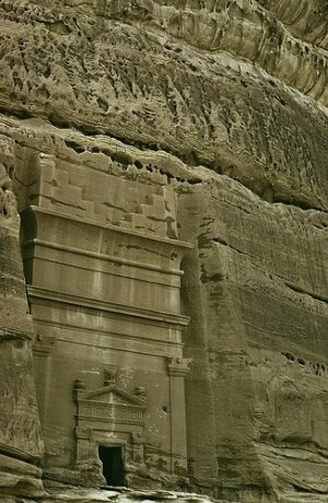
_________________________________
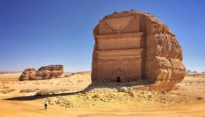
Qasr al Farid, tomb in the archaeological site Mada’in Saleh, AlUla. Richard.hargas, (CC BY-SA 4.0), Wikimedia Commons
_________________________________
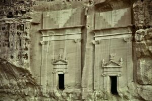
Above and below: Tombs at Mada’in Saleh. Tom and Linda Anderson, Public Domain, Wikimedia Commons
_________________________________
Who were they?
Historically speaking, the Nabataeans began as a nomadic, pastoral tribe, moving in the Arabian desert by following natural water resources needed for sustenance. They did not emerge as a notable civilization and polity until between the 4th and 2nd centuries BCE, when their kingdom was built around the lucrative trading network of the Incense Road, finally binging them wealth and some influence within the ancient world.
Once they became a power in their own right, the Nabataeans allied with the Hasmoneans in battle with the Seleucid monarchs. But they soon became local rivals of this Judaean dynasty, and Hasmonean king Alexander Jannaeus invaded and occupied Nabataea, followed by the successful attack by Nabatean king Obodas I, who defeated the Hasmonean forces near Gaulane and destroying the Judean army in about 90 BC. Beginning in 32 BC, under Herod the Great, conflict between Nabataea and Judea continued through a series of back-and-forth battles, with Herod’s forces usually gaining the upper hand.
As an ally of the Roman Empire during the 1st centuries BC and AD, the Nabataean kingdom flourished, Its influence expanding through Arabia to the Red Sea and as far south as present-day Yemen. During its heyday, Petra, the famous rock-cut remains of which lie in southern Jordan, exemplified the center of their power.
Despite its spectacular archaeological remains, however, relatively little is known about the Nabataeans — at least, in comparison to what we know today about the great civilizations that surrounded them. But archaeologists and other scientists are busy at work investigating the sites, and it is hoped that much more will be known about these people in time through careful and continuous efforts. The authorities and scientists at AlUla hope to make this happen, preserving what they find for the future. “We are pursuing several projects to ensure the safe preservation of the treasures in our custody,” says Alsuhaibani. “As ambitious as we are to show the world our archaeological discoveries, this is also a time to be meticulous. We are careful with our riches to ensure that they can continue to be researched and enjoyed by future generations.”*******
Arabia, prehistoric and ancient, never really was lost — just hidden. It only awaits scholars and scientists like Alsuhaibani to finally bring it to light.
____________________________________
*https://www.sciencedirect.com/science/article/abs/pii/S0277379118308138#!
***Huw Groucutt, One Small Arabian Finger Bone, Popular Archaeology, July 7, 2018.
****https://popular-archaeology.com/article/stepping-out/
Thomas, H., Kennedy, M., Dalton, M., McMahon, J., Boyer, D., & Repper, R. (2021). The mustatils: Cult and monumentality in Neolithic north-western Arabia. Antiquity, 95(381), 605-626. doi:10.15184/aqy.2021.51 https://doi.org/10.15184/aqy.2021.51
******‘The Use of Desert Kites as Hunting Mega Traps: Functional Evidence and Potential Impacts on Socioeconomic and Ecological Spheres’ by Rémy Crassard, et al, published in Journal of World Prehistory. Project sponsored by CNRS and French National Research Agency.
‘Kites of AlUla County and the Ḥarrat ‘Uwayriḍ, Saudi Arabia’ by Rebecca Repper, et al, published in Arabian Archaeology and Epigraphy. Project sponsored by RCU.
‘New Arabian desert kites and potential proto-kites extend the global distribution of hunting mega-traps’ by Olivier Barge, et al, published in Journal of Archaeological Science: Reports. Khaybar data in this article results from the Khaybar Longue Durée Archaeological Project.
******* Massive Late Neolithic animal traps in Arabia have archaeologists mobilized, October 24, 2022, Popular Archaeology Magazine, HK Strategies and the Royal Commission for ALULa press release of October 24, 2022.
********Mysterious ancient tombs reveal 4,500-year-old highway network in north-west Arabia, Royal Commission for AlUla , January 10, 2022.
********* Zaid, Zaydoon and Maraqten, Mohammed, The Peristyle Hall: remarks on the history of construction based on recent archaeological and epigraphic evidence of the AFSM expedition to the Awam temple in Marib, Yemen, Proceedings of the Seminar for Arabian Studies, Vol. 38, 2008
********** Abdulrahman Alsuhaibani, Rediscovering Ancient Arabia, Popular Archaeology, 1/14/2022.
__________________________________
 L
L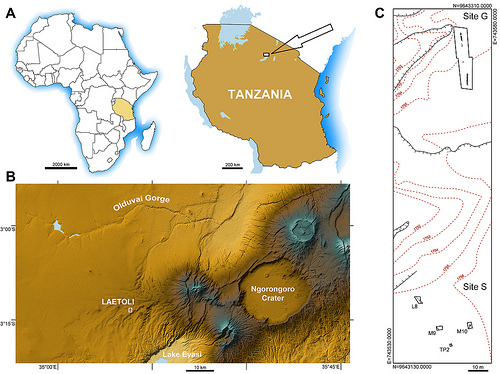
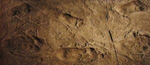
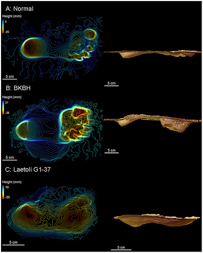
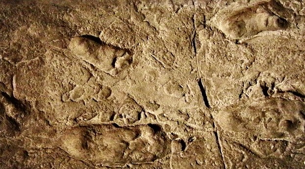
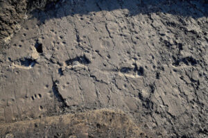
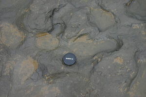
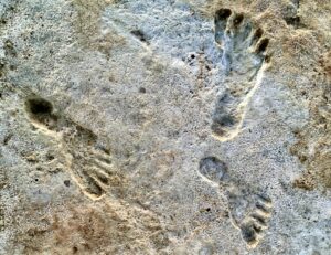
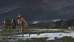
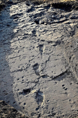 What they had hoped to find began to emerge. In this case, fourteen hominin footprints, along with those of other animals, eventually took form in three test pits. According to Cherin and his colleagues, the hominin prints represented a single individual walking to create, in this exposure, a trackway of 32 meters in an SSE to NNW direction— the very same direction as those uncovered at the earlier Laetoli footprint site in 1978. And the tracks bore a remarkable similarity to those of the earlier site, calculated with a similar walking speed. But there was one major exception — these footprints were significantly larger. Cherin and colleagues determined that they represented an individual with large relative stature and mass, standing 165 cm in height. By the end of the September 2015 field season, they discovered a second hominin trackway, this one made by a smaller individual. But the apparent size of the first, larger individual, was a surprise, particularly given the assessment that this person, like those who made the trackways at the earlier Laetoli site, was likely a member of the Au. afarensis species, a species generally thought to be significantly smaller in stature than hominins that evolved later in the human evolutionary spectrum. “We nicknamed him Chewie, after the famous Chewbacca of Star Wars,” said Cherin.


 I
I

 A
A


.jpg)
_(cropped).jpg)
.jpg)
,_Turkey_(7446237818).jpg)
.jpg)