
Standing at its base, it is impossible not to feel a sense of awe. Stretching high above and across, it is now covered with grass, stairs built against its face to enable the casual visitor to traverse its height to its summit, 100 feet skyward. It is not a natural hill. It is a massive mound of earth purposefully constructed by perhaps hundreds of toiling laborers more than 1100 years ago near present-day Collinsville, Illinois. Known today as Monks Mound, it is the largest monumental pyramidal construction north of the great ancient Maya centers in Central America. Indeed, at its base it is about the same size as the Great Pyramid of Giza of ancient Egypt, with a perimeter larger than that of the great Pyramid of the Sun in Teotihuacán, Mexico.
______________________________
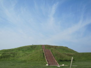
Monks Mound as it appears today.
______________________________
Monks Mound is arguably the most iconic example of the energy, ingenuity, sense of planning, and organizing capacity of a Native American population that otherwise would have blended into what many later European explorers and settlers would have judged as unremarkable “savages” on a landscape regarded ripe for the taking. But for over 5,000 years, a variety of peoples with both differing and common cultural traditions and heritage built thousands of similar mounds across thousands of square miles stretching from the Great Lakes to the Ohio River Valley to the Mississippi River Valley and this great river’s tributaries. Anciently, for the indigenous inhabitants who constructed these monumental earthworks, it was a land of abundance, a fertility that afforded unmatched hunting, fishing, and other food gathering. The region drew people and eventually supported large population centers, some of which rivaled and even exceeded the urban centers that grew from North American European settlement before the turn into the 19th century AD.
An Ancient Practice
When and where did this mound building begin?
By far the earliest example of this activity discovered to date can be found in southeastern Louisiana, a mound site that was radiocarbon dated to approximately 4500 BCE, although the dating is debated. It was initially excavated in 1967 as one of the two Monte Sano site mounds. If the dating is correct, this would place the site within the Archaic period. Better known, however, is the Watson Brake site, another Archaic period site located near Monroe in northern Louisiana. Dated to about 3500 BCE, long before the construction of the pyramids of ancient Egypt, it features 11 mounds from 3 to 25 ft in height, all connected by ridges that form an oval almost 900 ft across. Building continued for 500 years. In addition to this is the Archaic site of Poverty Point, also in Louisiana near the village of Epps in West Carroll Parish, which was built about 1500 BCE. A complex of more than one square mile, it consists of six earthwork crescent ridges arranged in a concentric pattern, divided by radial aisles. It also includes three mounds and evidence of residential construction extending about 3 miles along the bank of the Bayou Macon. Notably, the culture associated with Poverty Point has revealed archaeological evidence of a wide trading network showing commercial links with points well beyond its area of habitation.
The discovery and analysis of sites and artifacts from this time period have upended the traditional paradigm of monumental construction as a key activity that emerged out of developed agriculture and centrally organized societies. We now know that the peoples who originally constructed the mounds of sites like Watson Brake and Poverty Point were primarily hunter-gatherers, suggesting that there is much more to learn about the true capabilities and achievements of hunter-gatherer cultures, particularly in North America.
Archaeological inquiry related to the early cultures of North America has thus, among other things, explored the question of when and where developed agriculture and more complex, centralized societies, key elements of urbanization, actually emerged.
Smith Creek
Straddling the bluffs that overlook the Mississippi River in southwestern Mississippi sits an archaeological site known today as Smith Creek. It is one of many Native American mound sites that dot the 350-mile Mississippi Mound Trail near the banks of the Mississippi River. The site stands out from many of the others because it provides evidence of a long human occupation spanning 1,600 years across three different cultures, beginning with the Tchefuncte from about ca. 500 BC – 1 AD. The Tchefuncte, an Early Woodland period culture, were a hunter-gatherer people who lived in coastal areas and lowlands, living on a variety of food sources, including clams, alligators, fish, deer, raccoons and birds. They produced large amounts of simple pottery, which led to improved food management, better storage and cooking. But it was the Coles Creek Culture (ca AD 700 – 1200), the next group that occupied Smith Creek, that was responsible for the distinguishing monumental platform mound-and-plaza complex remains so prominently featured at the site. Coles Creek culture flourished during the Late Woodland period, generally in the Lower Mississippi valley. It marks a time when population increased dramatically, with evidence of increasing cultural and political complexity, such that near the end of its time they had developed simple elite polities. At Smith Creek, the archaeological evidence also shows a transition to another, succeeding culture, the Plaquemine (AD 1300 – 1500), a society distinguished by a continuation of the platform mound-and-plaza construction and, notably, maize agriculture (as well as cultivation of pumpkins, squash, beans and tobacco), although these people also continued to hunt, fish, and gather wild plants. The Plaquemines generally had established trade contacts with other Mississippian culture peoples to the north and east, contemporaneous with the Mississippian culture at Cahokia.
Megan Kassabaum, Assistant Professor of Anthropology and archaeologist with the University of Pennsylvania, has been exploring Smith Creek since 2013, when she conducted a series of test excavations. Based on those initial findings, she has returned to conduct full scale excavations in 2015, 2016, and 2018 with crews from the University of Pennsylvania. As Director of the excavations and research, she is exploring some key questions that will hopefully elucidate the evolution of the site. She hopes to eventually shed new light, at least at Smith Creek, on the transition from hunting and gathering to maize agriculture, from egalitarian to hierarchical social organization, from the use of the platform mound-and-plaza complexes as ritual centers to ongoing occupation as elite villages, and the relationship of these developments in time and function. “A suite of important social changes is thought to take place during Coles Creek and early Plaquemine times (i.e., at the transition between the Woodland and Mississippi Periods),” she says. “It is often stated that around this time people began regularly constructing large, flat-topped platform mounds, started relying heavily on corn agriculture, and began living in societies ruled by powerful chiefs. My work at Smith Creek aims to pick apart this complicated transition temporally and culturally to determine the complex relationships between these societal traits. In particular, I am interested in the relationships between monument construction, communal identity, and power.”
Thus far, her excavations have yielded, she says, millions of artifacts that include “even the tiniest evidence of human occupation” using methods from dry screening to wet screening and flotation for carbonized organic remains. Of these, well over 100,000 larger artifacts (1/4 inch and larger) have been excavated and analyzed. Most of the larger artifacts consist of ceramic sherds from storage, cooking, and serving vessels; animal bone (food remains); stone projectile points and other tools and debitage; and daub that was used in construction. In addition to that, her team found some bone tools, a quartz crystal, and a ceramic ear spool.
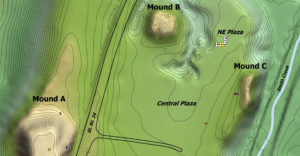
To date, the Smith Creek archaeological area consists of three large earthen mounds (Mound A, Mound B, and Mound C) surrounding an open plaza. Kassabaum describes Mound A as a platform mound that had been built in multiple stages, Mound B as a burial mound surrounded by a ditch, and Mound C as being less defined because much of it has eroded into a nearby stream. Reports Kassabaum:
“We have put excavation units into or near all three of the mounds at Smith Creek. On Mound A, we have investigated the final summit of the mound, a midden located on one of its previous summits, and the northern toe of the mound. Our excavations on Mound B have been limited because avocational excavations in the 1960s showed that the mound contained human remains. That said, I have done a detailed study of the records and artifacts associated with those early excavations and we have investigated a constructed platform that sits between the mound and the surrounding ditch. On Mound C, we have investigated the toe of the primary mound structure and a secondary structure that extends south off of the main mound. Finally, we have also focused excavations in off-mound areas including three different locations in the plaza. These have largely uncovered Plaquemine midden deposits, though in the Northeast Plaza area, we have spent a great deal of time investigating a probable Tchefuncte structure that underlies these midden deposits.”
___________________________________
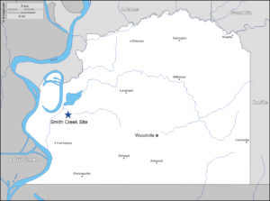
Location of the Smith Creek site within Wilkinson County, Mississippi. Base map from https://d-maps.com/carte.php?num_car=198678&lang=en.
___________________________________
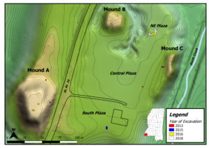
Topographic map of Smith Creek showing Mounds A, B, and C surrounding an open plaza. The 1960s excavation trench is visible as a dip along the southern flank of Mound B. Modern excavation units are shown as colored rectangles; Wilkinson County is colored red on the inset map. Map created by Kyle G. Olson.
Within the mound fill, we mostly recover pottery, but midden deposits have been excavated from mound surfaces in Mounds A and C. These surface deposits are made up primarily of ceramic and food remains. The ceramic styles present in these deposits, along with the radiocarbon dates, suggest that the mounds were largely constructed and used during Coles Creek times, though at least some additional construction seems to have taken place later on during Plaquemine times. The nature of the food remains on the mound summits and flanks suggests that food consumption might have played a role in the construction episodes. For example, on Mound C, we uncovered the articulated bones of a fish tail laying flat along the mound flank, suggesting that an episode of food consumption occurred immediately before the next phase of mound construction (such that no scavenging of the leftovers took place before they were buried with more fill).
Throughout the flotation samples that we take from the site, we find charred seeds of EAC (Eastern Agricultural Complex) plants including chenopod, maygrass, and knotweed. Though these analyses are just getting underway, initial examination of chenopod seeds under the scanning electron microscope indicate that both wild and domesticated varieties are present at the site. This fits well with the evidence from the nearby Feltus site, which also indicates domestication of chenopod during Coles Creek times. We also find a heavy reliance on nuts (hickory, pecan, walnut, and acorn) during the time.
— Megan Kassabaum
___________________________________
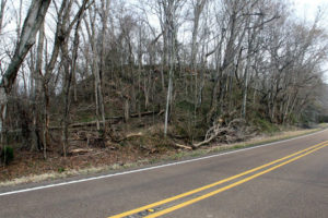
Photograph of Mound A at Smith Creek, looking northwest along Highway 24. Photo by Meg Kassabaum.
___________________________________
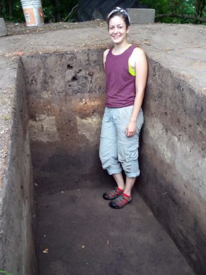
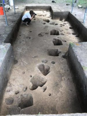
Field supervisor, Arielle Pierson, in the 2018 excavation unit south of Mound C. The unit walls show clear stratigraphic evidence of mound building and a post likely associated with a summit structure. Photo by Meg Kassabaum.
___________________________________
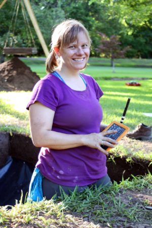
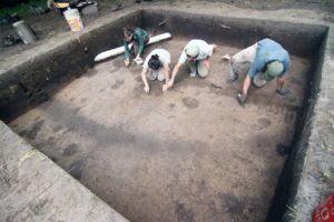
Dr. Meg Kassabaum on site in 2015, readying the South Plaza excavations for photography. Photo by Tom Stanley, Penn Museum.
___________________________________
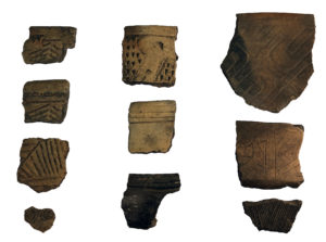
Diagnostic sherds from Smith Creek dating to the three primary periods of use: Tchefuncte (left), Coles Creek (middle), and Plaquemine (right). Photography by Meg Kassabaum.
___________________________________
Surprises and Implications
Along the way, Kassabaum and her team have encountered a few surprises. One of these was the surprisingly sizable amount of artifacts identifiable to the Tchefuncte period. Kassabaum states that Tchefuncte sites are comparatively few, and when they are found, the artifact assemblages are relatively small. Here, a significant number of Tchefuncte ceramic ware was found, associated with a large circular structure in the Northeast Plaza location of the site.
_____________________________________
2016 field school student, Isaac Burg, and field supervisors, Anna Graham, Ben Davis, and Kyle Olson, excavating in the Northeast Plaza. The profile walls of the excavation unit shows the thick Plaquemine midden and the unit floor shows the curving feature associated with the probable Tchefuncte structure. Photo by Meg Kassabaum.
_____________________________________
Dr. Meg Kassabaum on site in 2018, photographing features associated with the probable Tchefuncte structure in the Northeast Plaza. Photo by Arielle Pierson.
_____________________________________
In addition, Kassabaum was surprised to find evidence for a significant amount of earth construction beyond that required for the mounds themselves. “I was quite surprised to find large secondary structures associated with both Mounds B and C, both of which would likely have been written off as natural without archaeological testing,” says Kassabaum. “This is a good reminder that archaeological work regularly underestimates the degree of planning and amount of purposeful construction present at pre-contact sites.”
Thus far, a new picture is beginning to emerge about the developmental life of the site. Evidence supports a 1,600-year occupation, with three transitions. Kassabaum suggests that Smith Creek must have been a consistently important location, beginning as early as the Early Woodland and extending through Plaquemine times. Most of the mound-building (large flat-top platform mound surrounding a central plaza) took place during the Late Woodland Coles Creek time, built over a landscape that already must have had some meaning for the people who lived in the area. Curiously, no Middle Woodland occupation has yet been identified at the site.
This said, Smith Creek has some important implications within the larger context of the mound-building cultures in the region and in North America generally. “In general,” summarizes Kassabaum, “the Coles Creek culture represents an interesting moment in the history of mound building in the Eastern United States because it is when the platform mound-and-plaza complex that characterizes the subsequent Mississippian period becomes a widespread site type. My research, and the work being done by some of my colleagues, suggests that this site layout developed before the shift to corn agriculture and before the development of institutionalized status differentiation, which goes against the received wisdom about the type of sociopolitical organization that led to the construction of large platform mounds.”
Going Forward
Currently, Kassabaum and her team are working on completing the analysis of the latest, 2018 season finds. This includes acquiring a number of very important radiocarbon dates. “Accurately dating the various assemblages is essential for this site because of the surprisingly early age of some of the deposits,” says Kassabaum, “and it is important to determine at what point in history important changes like reliance on maize agriculture developed.”
In the future, Kassabaum hopes to further understand the degree to which the inhabitants modified the landscape and answer questions about mound functions, which will include some additional investigation/testing of the platform mounds. Specifically, this would entail opening up a large excavation at the summit of Mound A to determine what function any building at that location performed. Additionally, she would like to identify more middens that might be associated with the Coles Creek Culture in order to understand and compare the various activities that may have occurred at the site over time.
_____________________________________
For interested visitors, Smith Creek, near Woodville, Mississippi, is marked with a historical marker that explains the site. Smith Creek is also featured in the exhibit, Moundbuilders: Ancient Architects of North America at the Penn Museum in Philadelphia. A small exhibit about Mississippi’s mound builders and the work at Smith Creek is also projected to open at the Wilkinson County Museum in Woodville in June 2019.
Readers can follow the Smith Creek adventure on Facebook (https://www.facebook.com/22WK526/) or Instagram (https://www.instagram.com/scapupenn/). More general information about North American Archaeology at the University of Pennsylvania can be found at: https://www.sas.upenn.edu/anthropology/content/north-american-archaeology. Finally, readers may also learn about the other 32 mound sites on the Mississippi Mound Trail at http://trails.mdah.ms.gov/mmt/index.html.
________________________________


