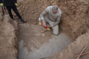
Florence, Italy — Following a complex three-year process involving teams of experts, Museo di Palazzo Vecchio’s Wardrobe, commonly known as the Map Room—the most visited gallery in the museum—has been fully restored thanks to funding provided by Friends of Florence.
The project included restoration of both the large terrestrial globe and 53 maps of the world as it was known in the second half of the 16th century commissioned by Duke Cosimo I de’ Medici. The process also involved the structural consolidation of the floor, the installation of a domotic lighting system, the complete overhaul and maintenance of the 13 monumental walnut cabinets with carved decorative motifs by Dionigi di Matteo Nigetti; and the replacement of protective acrylic panes with modern antiglare panels.
The operation was devised and managed by Palazzo Vecchio’s Servizio Belle Arti e Fabbrica under the Direzione Servizi Tecnici in conjunction with the Direzione Cultura’s Servizio Musei. Most of the process was conducted on site so visitors could watch the restorers at work.
In tandem with the restoration, the Museo Galileo, thanks to an accord stipulated with the Comune di Firenze, developed a website enabling users to conduct an interactive 3D exploration of the room, which has been reconstructed digitally along with the globe and works of art it houses. An illustrated publication documenting the restoration process will be published by Mandragora in 2025. Both the website and publication are also supported by Friends of Florence.
The Map Room, a valuable part of the Palazzo Vecchio museum, has been restored to its former glory,” said Florence Mayor Sara Funaro. “This room of immense historical importance has been the object of a complex and meticulous operation thanks to the unflagging involvement of Palazzo Vecchio’s Servizio Belle Arti e Fabbrica. The superb globe in the center of the room, one of the oldest in the world, has also recovered its original beauty. And it is now going to be possible, quite literally, for users to immerse themselves in this unique environment thanks to the innovative technology developed by the Museo Galileo. A huge thank you to Friends of Florence, which is once again working hand in hand with our city to safeguard and enhance its artistic heritage.”
“This is one of the best-loved parts of our museum and now, after its restoration, it is even more beautiful,” opined Councilor for Cultural Affairs Giovanni Bettarini. “Thanks to the generosity of Friends of Florence, this room is once again a treasure house of beauty and knowledge that illustrates for us how the world was known back in the days of Grand Duke Cosimo I. This restoration, conducted by our distinguished experts and restorers, has been truly fascinating to track and now allows us to see this room as it was in the Renaissance, with an interesting 3D virtual tour produced thanks to the expertise of the Museo Galileo.”
“The Palazzo Vecchio Wardrobe study and restoration program has been a fascinating undertaking that has brought art, history, and geography together in a single project,” said Friends of Florence President Simonetta Brandolini d’Adda. “After three years’ work, the result is truly extraordinary. We thank Palazzo Vecchio’s Servizio Belle Arti e Fabbrica, the Servizio Tecnici, the Direzione Cultura’s Servizio Musei, and the Museo Galileo for their collegial partnership. We are also immensely grateful to our donor, the Giorgi Family Foundation, for their generous support for this special project.”
Soprintendente Antonella Ranaldi added, “This complex restoration, which has brought together the various institutions involved, is accompanied by explanatory videos and 3D models and by a dedicated publication, providing a splendid example of public- and private-sector involvement, and with Friends of Florence playing a proactive role in the funding.”
Background
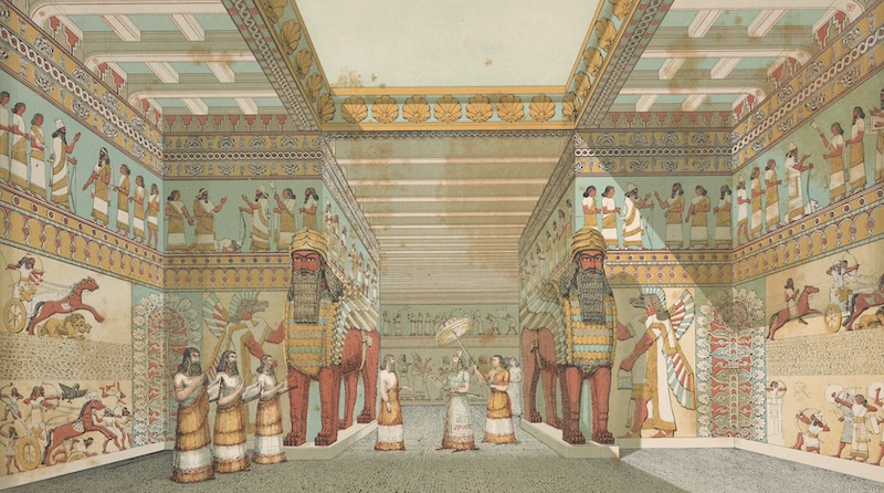
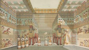
The Map Room
When Duke Cosimo I de’ Medici (1519–1574) moved into the Palazzo Vecchio, the adjacent buildings were used as the Wardrobe, space in which the court’s movable property was stored. Beginning in 1661, this area was transformed under the direction of Giorgio Vasari to display, per the Duke, all the “things of heaven and earth.” The room’s design, devised by Vasari with cosmographer Fra’ Miniato Pitti and still partly unfinished at Cosimo’s death, featured 57 maps of lands then known in Europe, Africa, Asia, and the New World fitted as panels on the doors of the large wooden cabinets.
The ceiling, decorated with allegorical figures of the constellations, was to open to allow two large globes to drop down from a star-spangled vault: the celestial globe, which may never have been made, was to remain suspended in mid-air, while the extant terrestrial globe was to be lowered to the ground. The design also provided for busts of princes and emperors and the first 300 portraits of illustrious men in the Gioviana Collection (subsequently transferred to the Galleria degli Uffizi) to be displayed between the cabinets and the ceiling. The idea of displaying all the “things of heaven and earth” in a single room reflects Cosimo’s interest in the natural and mathematical sciences, geography, and trade, but also the Duke’s self-celebratory projects alluding to his name and the Greek word “cosmos.”
____________________________
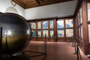
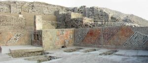
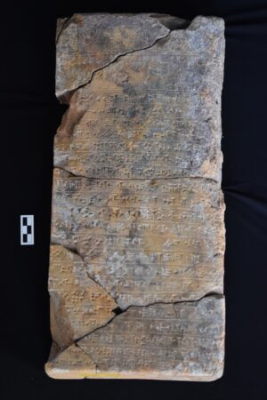
“Sala della Guardaroba” (Wardrobe Room, or commonly known as the Map Room), 16th century, Palazzo Vecchio, Florence, Italy, after 2021-24 restoration with support from Friends of Florence. Terrestrial globe and geographical maps by Egnazio Danti and Stefano Bonsignori with walnut cabinets by Dionigi di Matteo. Photo courtesy of Comune di Firenze.
____________________________
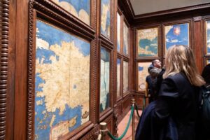
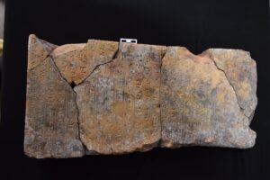
“Sala della Guardaroba” (Wardrobe Room, or commonly known as the Map Room), 16th century, Palazzo Vecchio, Florence, Italy, after 2021-24 restoration with support from Friends of Florence. Detail of geographical maps by Egnazio Danti and Stefano Bonsignori with walnut cabinets by Dionigi di Matteo Nigetti. Photo courtesy of Comune di Firenze
____________________________
The Maps
The 13 large walnut cabinets (initially used to store tapestries and other textiles) were made by Dionigi di Matteo Nigetti between 1564 and 1571. Of the 57 maps in the original design, only 53 survive. Thirty of these were based on a design by the Dominican cosmographer Fra’ Egnazio Danti and completed in 1575, while the others were designed by his successor, the Olivetan monk Dom Stefano Bonsignori. The groups differ essentially in the techniques adopted by the two artists. Danti’s technique is akin to painting on paper and parchment reminiscent of illuminated codices, with inscriptions, profiles, and chiaroscuro outlined in ink. Bonsignori’s applied opaque brushwork using oil paints most commonly used at the time.
The spectacular globe in the center of the room, which measures some 220 cm. in diameter, is the world’s earliest surviving large-scale model of Earth. It was made with immense skill at a time when the technique for building such scientific instruments had not yet been codified. It was first fashioned between 1564 and 1569 by Fra’ Danti with the Medici court architect and engineer Antonio Lupicini who made its interior shell and its external iron structure “with such a new technique that with one finger alone that huge machine could be moved in every direction,” as Giorgio Vasari noted at the time. After it had become impossible to produce the amazing, theatrical machine envisioned by Cosimo I, the globe was moved to the new ducal residence in the Palazzo Pitti, before being transferred to the Terrazzo degli Uffizi around 1594.
In 1776, the globe was moved once again along with the entire grand ducal collection of scientific instruments to the new Museum of Physics and Natural History known today as La Specola. It remained there until the Comune di Firenze had it restored in the 1950s and returned to the room in Palazzo Vecchio for which it had originally been designed.
As restorers discovered during the intervention, however, the globe now in Palazzo Vecchio is no longer the one produced to Fra’ Danti’s design. After only a few decades its surface was restored – and possibly updated – on two separate occasions. The first was completed by court cosmographer Antonio Santucci in 1597 and the second a decade later by his successor Matteo Neroni.
An analysis of its surface, a historical and cartographical examination of the countries depicted, and a series of hitherto unknown archival documents discovered as the project was underway, show that between 1605 and 1613, Neroni did not confine himself to simply restoring and updating Fra’ Danti’s globe. Rather, he completely demolished it in order to rebuild it from scratch, from its innermost layers, possibly salvaging only the main part of the iron shell that Lupicini had made some 40 years earlier.
Restoration
The various restoration procedures were accompanied by a full program of multispectral photographic documentation and analyses. The globe was also recorded through the various phases of restoration with photogrammetrical surveys and the production of three-dimensional models. Its interior was inspected with a videoendoscope enabling restorers to get a clear picture of the composition of every layer in the painted surface’s complex support system.
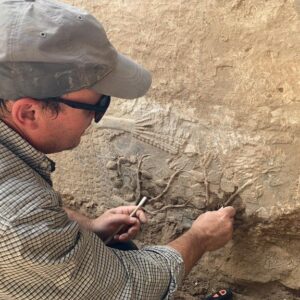
The maps were restored in the adjacent Old Chancellery, in full public view, with the paintings being removed from the cabinet doors one at a time and then returned after restoration. Their wooden supports were in good condition overall, but both groups displayed defects in relation to the painting technique used: the paint and colors had deteriorated in the areas representing the sea on Bonsignori’s panels. The paintings’ legibility was seriously impaired by the effects of earlier restorations. Aggressive cleaning had worn down the painted surfaces; consolidations created stains; materials used over time had deteriorated; and the surfaces were extensively covered in a brown patina.
The present restoration project was designed to improve the painted panels’ legibility by conducting selective thinning or removal of the earlier restoration materials and retouching.
The operation enabled restorers to recover color values consistent with the original palette, such as the intense lapis lazuli blue of the seas in Fra’ Danti’s panels and the gleam of the tonal transitions in Bonsignori’s work.
The terrestrial globe, which could not be moved, was restored on site allowing the public to view the process. Barely legible and badly damaged by being moved around over the centuries and exposed to the elements when it stood in the courtyard of the Museo della Specola in the 19th century, the globe was removed from its external iron structure and placed on a wooden base. The challenging cleaning operation was conducted in two phases. First, the thick layer of repainting was completely removed. The second phase required removing, one by one, the countless residual black vestiges of old oil-based retouching that may have dated back to a 19th-century restoration.
The stunning, original palette was revealed. Lapis lazuli was used for the blue seas rippling with waves traversed by ships and sea creatures; gold for the inscriptions; ochre and malachite for the land masses with their reliefs highlighted and sparkling with golden specks; and cinnabar red for the islands and cities represented by small castles or by dots and the lines of the geographical grid.
The globe’s external support structure consisting of various iron pieces was dismantled, restored, and reassembled. This operation confirmed that the most important surviving iron elements are still the original pieces, despite their repeated disassembly and other interventions. The cleaning operation to remove deteriorated protective materials and surface corrosion revealed the details of the engraved graduations and inscriptions that had been invisible.
____________________________
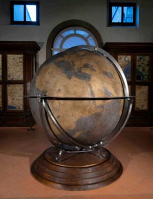
“Sala della Guardaroba” (Wardrobe Room, or commonly known as the Map Room), 16th century, Palazzo Vecchio, Florence, Italy, after 2021-24 restoration with support from Friends of Florence. Detail of terrestrial globe by Egnazio Danti and Stefano Bonsignori. Photo courtesy of Comune di Firenze
____________________________
Website
Designed by the Museo Galileo with the support of the Friends of Florence, the new website is a 3D digital model of the cosmographical and geographical content in the renovated Map Room. Zoomable, it is designed to facilitate access to the room, maps, and globe with links to additional information. Visitors may rotate the model globe in any direction; see the metal and wood supports and materials used inside; and explore the surface and locations depicted.
Videos include an introduction, six segments devoted to the historical figures involved in the room’s layout and design, and two illustrating the designs themselves, one devised by Giorgio Vasari and a variant by architect and cosmographer Antonio Lupicini.
The protagonists in the videos are: Grand Duke Cosimo I de’ Medici, who first envisioned the project; Vasari, his architect and the designer of the mechanical equipment intended to make the model cosmos come to life; the cosmographer Dom Miniato Pitti charged by Vasari to produce the cosmographical mechanism; Cosimo I’s cosmographer Fra’ Egnazio Danti responsible for the terrestrial globe and for the majority of the cosmographical panels painted on the cabinet doors; Francesco I’s cosmographer Dom Stefano Buonsignori produced the rest of the cosmographical panels; and Antonio Lupicini designed the globe’s metal structure and devised a variant for the mechanical equipment which, in the end, was never built. https://mostre2.museogalileo.it/palazzovecchio-guardaroba/index.php/en/
Museo Galileo’s Scientific Director Filippo Camerota said, “The website project developed by the museum will enable anyone to virtually explore the Palazzo Vecchio museum’s Wardrobe in such a way that they will be able to consult content in detail, read the texts, and analyze information in greater depth. This useful tool for researchers, scholars, and enthusiasts alike is a research project that testifies to our institution’s commitment to combining the stringent study of historical sources with innovative ways of making information available to a broader audience, acting in synergy with the leading public- and private-sector players in our region.”
“The maps of Danti and Buonsignori, are on permanent loan to Palazzo Vecchio from the Gallerie degli Uffizi,” said Simona Pasquinucci, who is in charge of the Gallerie degli Uffizi’s Curatorial Department. “They have recovered their brilliance and their luminosity thanks to the restoration funded by the Friends of Florence, whom we thank profusely. It has proven to be a highly productive collaboration, for which we are grateful to the Comune di Firenze.”
___________________________
About Friends of Florence
Friends of Florence is a non-profit foundation supported by individuals from around the world who are dedicated to preserving and enhancing the rich cultural heritage of Florence and Tuscany and conserving irreplaceable artistic and cultural treasures. Friends of Florence identifies significant projects spanning centuries in need of restoration, secures funding, and works in collaboration with local authorities to complete projects.
Since its founding in 1998, the Foundation has raised and donated $10 million for conservation projects in the region. Friends of Florence works directly with Florence’s famed conservation laboratories to ensure restoration is done at the highest level, has the approval of the City of Florence and the Italian Ministry of Art, and is completed on time and on budget.
Through its work, Friends of Florence creates opportunities for the study and appreciation of paintings, sculptures, architectural elements, places of worship, and collections at the Uffizi Gallery, the Accademia, the Baptistry, the Piazza della Signoria, the Museum of San Marco, and dozens of other museums, churches, and public sites.
A model of high-impact, low-overhead philanthropy, Friends of Florence is the primary source of funding for the city’s conservators, a respected partner with museums and cultural authorities in Italy and the U.S., and a publisher/producer of publications, multimedia offerings, seminars, lectures, and cultural travel opportunities. www.friendsofflorence.org
___________________________
Advertisement

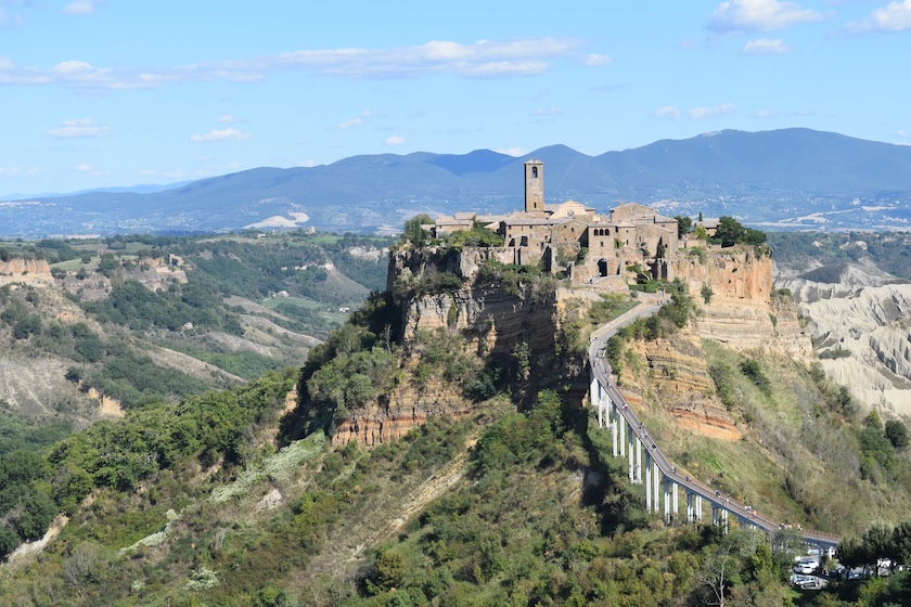
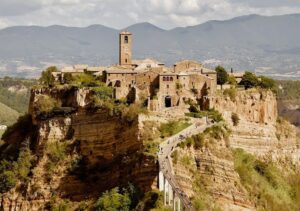
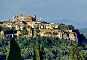
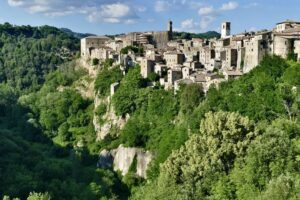
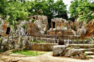
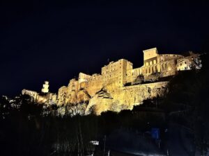
EXPLORE THE ANCIENT ETRUSCANS IN PERSON!
Experience a unique, up-close-and-personal hike among ancient hilltop towns in central Italy. You will walk the sensational countryside of the regions of Umbria and Tuscany, soaking in important sites attesting to the advanced Etruscan civilization, forerunners of the ancient Romans; imposing architectural and cultural remains of Medieval Italy; local food and drink; and perhaps best of all — spectacular scenic views! Join us in this collaborative event for the trip of a lifetime!