AlUla, Saudi Arabia, 24 October 2022: New peer-reviewed research into ancient stone-built animal traps, known as ‘desert kites’, reveals sophisticated and extensive hunting of wild animals from the Late Neolithic and shows the ingenuity and perhaps collaborative nature of the region’s peoples in the past.
The structures were named ‘kites’ by aviators in the 1920s because, observed from above, their form is reminiscent of old-fashioned children’s kites with streamers. However, the origins and function of these huge, monumental structures had been a matter of debate.
Dr Remy Crassard, a leading expert on desert kites, notes that they are some of the largest ancient structures of their era. The oldest kites, in southern Jordan, have been dated to 7000 BCE. The age of newly found kites in north-west Arabia is still being determined but appears to straddle the transition from the Late Neolithic to the Bronze Age (5000–2000 BCE). Dr Crassard – who, besides being affiliated with France’s National Centre for Scientific Research (CNRS), is a co-director of the Khaybar Longue Durée Archaeological Project, which is sponsored by RCU and its strategic partner Afalula (France’s Agency for the Development of AlUla) – estimates that 700 to 800 kites were known 20 years ago compared to about 6,500 now, with the number still growing.
Based on recent research conducted in Saudi Arabia, Jordan, Armenia and Kazakhstan, Dr Crassard’s team affirms that kites were used for hunting and not for domestication, that they “mark a profound change in human strategies for trapping animals”, and that “the development of these mega-traps made a spectacular human impact on the landscape”. Kites may have led to hunting well beyond subsistence levels, related to “an increase in symbolic behaviour related to food production and social organisation”. Some wild species such as gazelles might have altered their migratory routes as a result, and other species might have been hunted to extinction.
In Saudi Arabia, research led by Rebecca Repper of the University of Western Australia’s RCU-sponsored team, Aerial Archaeology in the Kingdom of Saudi Arabia – Al Ula, detected 207 previously unknown kites in AlUla County. These are especially concentrated on the Harrat ‘Uwayrid, an upland area with an extinct volcano. The team found that a distinct type of V-shaped kite was the dominant form in their study area, in contrast to kites found elsewhere in the region. Kites have been described in a variety of shapes, including V, ‘sock’, ‘hatchet’ and W-shaped.
Regardless of form, all kites in the region have driving lines of low stone walls that converge to funnel animals towards a trap such as a pit or precipice. On average, the driving lines of the AlUla kites are approximately 200m long. However, elsewhere they can stretch for kilometres. Ms Repper says the shorter length shows the local knowledge of the hunters, who placed the traps in areas where existing landscapes naturally restricted animal movements. Kite placement also suggests that the hunters had an intimate knowledge of prey movements.
While kites recorded in the AlUla region tended to funnel prey towards a sudden precipice, kites elsewhere often end in concealed pits, in which hundreds of animals could be killed during a single hunt. This difference could be an adaptation to the local geography or an evolution of trap hunting.
The aerial archaeology team’s research in the region complements work by Dr Crassard, who contributed data on the kites of Khaybar to a recently published study led by Dr Olivier Barge (CNRS) on the relative chronology of kite types. In Khaybar, two types of kites have been distinguished: traditionally defined desert kites and rudimentary proto-kites, which do not have a well-defined enclosure surrounded by traps or pits. The team suggests that the proto-kites might have been a precursor to desert kites. The more complex kites may reflect less opportunistic and more formalized hunting techniques.
Dr Rebecca Foote, Director of Archaeology and Cultural Heritage Research for RCU, said: “These studies add to our growing understanding of the rich cultural heritage of the people of north-west Arabia, in this case more on prehistoric practices. The recent studies expand on our earlier discoveries of the Neolithic period in the region, including the construction of large-scale ritual structures known as mustatils. As we embark on the autumn season of RCU-supported archaeological fieldwork, with teams from KSA, France, Australia, Germany and beyond, we look forward to many more insightful findings as part of our ambitious plan to create a global hub of archaeological research and conservation in AlUla.”
That hub, the Kingdoms Institute, is currently active as a research organization, with plans to open a physical presence at AlUla by 2030. The RCU-sponsored research in and around AlUla is adding to the knowledge base that will inform the Kingdoms Institute. RCU expects the institute to become a prime destination by the time AlUla is receiving 2 million visitors a year in 2035.
Dr Ingrid Périssé Valéro, Director of Archaeology and Heritage for Afalula, said: “The recording of these new kites in AlUla and Khaybar opens up important perspectives on the origins, development and diffusion of these hunting structures, which marked a significant milestone in the history of human evolution and mankind’s relationship with the natural environment. The groundbreaking research from these international teams, including work by France’s expert Dr Rémy Crassard, combines the results of satellite image analysis and fieldwork, which is the only way to provide precise dating and function by analysing the material associated with these structures. Without a doubt, the ongoing research will be a landmark in prehistorical studies.”
________________________________
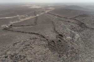
A kite in the Khaybar area of north-west Saudi Arabia. New archaeological findings on kites show the ingenuity of the region’s peoples in the past. (Diaa Albukaai and Kévin Guadagnini, Khaybar Longue Durée Archaeological Project/RCU/Afalula/CNRS)
________________________________
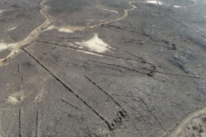
A kite in Khaybar. These ancient hunting traps were named ‘kites’ by aviators in the 1920s because, from above, they resemble old-fashioned children’s kites. (Diaa Albukaai and Kévin Guadagnini, Khaybar Longue Durée Archaeological Project/RCU/Afalula/CNRS)
________________________________
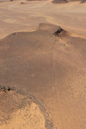
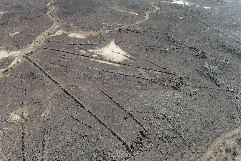
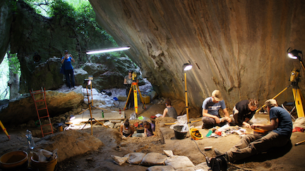
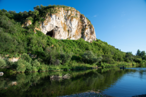
This and the following photograph show an ancient ‘kite’ in a sandstone landscape in AlUla County, north-west Saudi Arabia. The walls of this kite extend about 300 metres across a mesa … (Don Boyer/RCU/AAKSAU)
________________________________
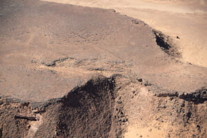
… leading to a sudden precipice over which hunters drove prey including gazelles and ibex. (David Kennedy/RCU/AAKSAU).
________________________________
The recent research is detailed in the following:
• ‘The Use of Desert Kites as Hunting Mega Traps: Functional Evidence and Potential Impacts on Socioeconomic and Ecological Spheres’ by Rémy Crassard, et al, published in Journal of World Prehistory. Project sponsored by CNRS and French National Research Agency.
• ‘Kites of AlUla County and the Ḥarrat ‘Uwayriḍ, Saudi Arabia’ by Rebecca Repper, et al, published in Arabian Archaeology and Epigraphy. Project sponsored by RCU.
• ‘New Arabian desert kites and potential proto-kites extend the global distribution of hunting mega-traps’ by Olivier Barge, et al, published in Journal of Archaeological Science: Reports. Khaybar data in this article results from the Khaybar Longue Durée Archaeological Project.
_________________________________
Article Source: HK Strategies and Royal Commission for ALULa
__________________________________________
About the Royal Commission for AlUla
RCU was established by royal decree in July 2017 to preserve and develop AlUla, a region of outstanding natural and cultural significance in north-west Saudi Arabia. RCU’s long-term plan outlines a responsible, sustainable, and sensitive approach to urban and economic development that preserves the area’s natural and cultural heritage, while establishing AlUla as a desirable location to live, work, and visit. This encompasses a broad range of initiatives across archaeology, tourism, education, the arts, nature and more, reflecting a commitment to meeting the economic diversification, local community empowerment, and heritage preservation priorities of Saudi Arabia’s Vision 2030 programme.
About Afalula (French Agency for the Development of AlUla)
The French Agency for the Development of AlUla (Afalula) was founded in Paris in July 2018 following an intergovernmental agreement signed by France and Saudi Arabia in April of that year. Afalula aims to support its Saudi partner, The Royal Commission for AlUla (RCU), in the co-construction of the economic, touristic and cultural development of AlUla, a region located in north-west Saudi Arabia which benefits from outstanding natural and cultural heritage. The agency’s mission is to mobilise French knowledge and expertise and to gather the finest operators and companies in the fields of archaeology, museography, architecture, environment, tourism, hospitality, infrastructure, education, security, equestrianism, agriculture, botany and the sustainable management of natural resources.
_________________________________
If you liked this, you may like the newly published feature article in Popular Archaeology: Lost Worlds of Arabia.
Advertisement


,_1st_cent._CE,_Saudi_Arabia_(8).jpg)