UNIVERSITY OF PENNSYLVANIA—Africa, where humans first evolved, today remains a place of remarkable diversity. Diving into that variation, a new analysis of 180 indigenous Africans from a dozen ethnically, culturally, geographically, and linguistically varied populations by an international scientific team offers new insights into human history and biology, and may inform precision medicine approaches of the future.
The work clarifies human migration histories, both historical and more recent, and provides genetic evidence of adaptation to local environments, manifested through traits such as skin color, heart and kidney development, immunity, and bone growth.
The findings, published in the journal Cell and led by University of Pennsylvania researchers, also have implications for understanding health conditions common in people of African ancestry. And, because African populations have been underrepresented in genomic studies, the investigation significantly expands what is known about human genetic diversity. The investigation turns up millions of new genomic variants known as single nucleotide polymorphisms (SNPs)—differences in one “letter” of the DNA sequence—including many that appear to play roles in health, laying the groundwork for a broader swath of people to benefit from precision medicine based on individual differences.
“There is a lack of knowledge about genomic variation in African populations, particularly in ethnically diverse populations,” says Sarah Tishkoff, a Penn Integrates Knowledge University professor at Penn and senior author on the work. “We focus on populations who practice more traditional lifestyles, live in remote areas that can be difficult to access, and some of whom have never been studied from this perspective before.”
Origins and migrations
Researchers obtained complete genome sequences for 180 individuals—15 from each of 12 indigenous populations. The study is the first to perform rigorous whole-genome sequencing of such a genetically diverse mix of African groups.
“From the perspective of an African physician-scientist, our work demonstrates the importance of long-term scientific collaborations and highlights the urgent need to include more African populations in genetic studies,” says Alfred Njamnshi, a professor at Cameroon’s University of Yaoundé I and a study coauthor. “If all humans came out of Africa, as increasing evidence suggests, it would simply be expected that more effort and resources will be put into studying human genetics in Africans, so as to better understand not only human genetics but human physiology and pathology in general, the basis for more precise human medicine.”
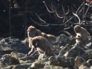
The 12 populations practice, or practiced until recently, traditional livelihoods: farming, livestock herding, or hunting and gathering. Together, they include representatives from each of the four different language families present in Africa: Afroasiatic, Nilo-Saharan, Niger-Congo, and Khoesan.
Placing the new genome sequences from these African populations in context with other, previously sequenced genomes from populations across the globe, the research team crafted a worldwide family tree.
“Inferring African demographic history is very challenging because the history is so complex,” Tishkoff says. “But, with our models, based on shared patterns of genomic variation, you can infer when populations shared a common ancestor, even when accounting for gene flow—populations migrating in and out and interbreeding.”
When the team allowed for gene flow in their models, they found that the southern African Khoesan-speaking group, the San, as well as Central African, rainforest-dwelling hunter-gatherers appeared at the root of the tree. “That’s a very novel result,” Tishkoff says. Previous analyses had pointed to only the San as descending from the most ancient populations.
They also found that the San and Central Africa hunter-gatherer groups split from one another, and from other known populations, more than 200,000 years ago.
Population ancestry models turned up evidence of a now-extinct “ghost” population that may have intermixed with other groups at the time. “We don’t have ancient DNA from fossils because they don’t preserve well in an African environment, but one explanation is there could have been mixing with an archaic population,” Tishkoff says.
The findings add support to linguistics-backed theories of population structure. Linguists have debated whether Khoesan-speaking groups—whose languages share click consonants but are highly distinct in their other features—were truly closely related. According to genomic results, though these groups diverged tens of thousands of years ago, there is evidence that all of them may have shared a common origin in East Africa, and shared more recent gene flow, during the last 10,000 years.
“What we propose is that there may have been an East African origin for these click-speaking groups, and maybe even the rainforest hunter-gatherers as well, though they’ve since lost their original language and adopted the language of the neighboring Bantu-speaking populations,” says Tishkoff. “The groups may have split in different directions, with the Hadza and the Sandawe (Khoesan speakers from Tanzania) staying local and the San (Khoesan speakers from Botswana) moving south.” However, analysis of modern and ancient DNA indicates that there has been gene flow between the ancestors of the Hadza and Sandawe and the ancestors of the San, which could potentially explain some similarities in their language.
Advertisement
______________________________

_______________________________
Newly understood human genetic diversity
The newly sequenced genomes identified 32 million SNPs, including more than 5 million that had never before been cataloged.
“The 32 million SNPs that were analyzed have just shed a new light on the importance of extending genetic studies in regions that have been previously marginalized around the globe,” says study co-author Thomas B. Nyambo of Kampala International University in Tanzania. “This is the way forward in the elucidation of evolutionary trends and their implication in tailored diagnostics and therapeutics.”
When the research team cross-referenced the previously identified SNPs with those in a widely used database used for clinical studies, they discovered many of the variants found in the African individuals in the study had been classified as pathogenic.
“This does not mean African populations have more ‘pathogenic’ variants,” says Shaohua Fan, a lead study author who completed a postdoc at Penn and is now at China’s Fudan University. “Rather, it emphasizes a strong need to include ethnically diverse populations in human genetic studies, especially because rarity is one criteria for determining a variant’s pathogenicity in clinical studies.”
In other words, some of these variants may have been miscategorized as associated with disease only because they were so uncommon in other populations, such as Europeans, which dominate these clinical databases.
“Comprehensively assessing genetic variants has been used as a strategy to study human disease and provides tremendous power to identify new loci associated with disease susceptibility and progression,” says Sununguko Wata Mpoloka of the University of Botswana. “Including understudied indigenous populations like those from Botswana in such studies will contribute tremendously to an understanding of precision medicine and could lead to tailormade drugs specific to such populations.”
Some of these variants may indeed play a meaningful role in health and disease. To get at these associations, the researchers not only compared mutations to existing databases and published studies, but also looked to see whether the variations occurred in the coding regions for proteins or in regions that could regulate gene expression for biologically relevant pathways and processes. They also looked for versions of a mutation, known as alleles, that occur at significantly different frequencies in different populations. These differences may arise because the alleles play a role in local adaptation to diverse environments and are positively selected, presumably because they confer some advantage to the people who carry them.
Several notable variants emerged from these analyses. In the San population of southern Africa, for example, the team found high numbers of SNPs near the PDPK1 gene, which had been shown by other scientists to play a role in pigmentation in mice. “Based on prior studies in our lab, we know that the San have relatively light skin color compared with other African populations,” says Yuanqing Feng, a postdoctoral researcher in the Tishkoff lab and a study co-author. “Thus, we hypothesized that SNPs near PDPK1 may affect pigmentation in humans.”
To generate mechanistic evidence for that hypothesis, the researchers tested the effect of one of these SNPs—shown to be common in the San—in skin cells grown in a petri dish. They found that inhibiting the region containing the variant altered expression levels of PDPK1 and reduced the levels of the skin pigment melanin in the lab-grown skin cells.
Other connections with health and function emerged from the study. The team’s analysis found a large number of variants near genes associated with bone growth in the Central African hunter-gatherers. These groups are known for their short stature, which is believed to be advantageous for the thick rainforest environment where they live. In pastoralist populations from East Africa, the team discovered enrichment for variants near genes that play a role in kidney development and function, possibly an adaptation to living in arid conditions. And in the Hadza hunter-gatherers in East Africa, they found a unique enrichment of variants near genes that play a role in heart development.
“My lab is now following up with some of these genes to see whether we can learn about the genetics of heart muscle development,” says Tishkoff. “If we understand how these genes are regulated, that could give us a clue as to why some people have a tendency toward cardiovascular disease. To understand abnormal function, you first have to understand normal function, and we speculate that there’s something about these individuals’ lifestyles—having to walk incredibly long distances, for example—that might make it advantageous to have certain changes in how the heart develops and functions.”
In addition, the researchers found gene variants related to blood pressure control in people with Nilo-Congo ancestry, West African groups that share ancestry with people from whom most African Americans are descended. “There’s a high incidence of hypertension and diabetes in people of African ancestry in the United States, and that’s largely due to socioeconomic factors,” Tishkoff says. “But there could be some genetic risk factors that, together with the environment in which they live, influence their risk for disease. Some of these could be adaptive in an African environment but maladaptive in a U.S. environment.”
These new datapoints may one day help inform precision medicine approaches that rely on understanding how genetics and other individual differences affect people’s disease risk, response to drugs, and more.
“There’s a huge amount of genomic variation in Africa that has not yet been well characterized,” Tishkoff adds. “We want to make sure all populations benefit from the genomics revolution, and we want to promote health equity, and therefore we need to include more diverse populations in these studies.”
_______________________________

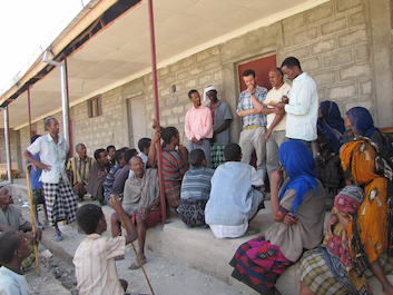
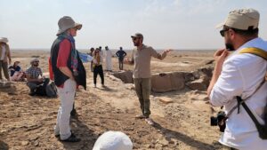
With the help of a local translator, Simon Thompson (in blue plaid shirt) from Sarah Tishkoff’s lab and Dawit Wolde-Meskel (in yellow shirt), a collaborator from Addis Ababa University, explain the research project on African population genetics to the Argobba population in Ethiopia. New findings from a study of 12 diverse groups in Africa shed new light on the origin of modern humans, ancient and more recent migrations, and local adaptation. Courtesy of the Tishkoff Laboratory
_______________________________
Sarah Tishkoff is the David and Lyn Silfen University Professor in Genetics and Biology and a Penn Integrates Knowledge University Professor with appointments in the Perelman School of Medicine’s Department of Genetics and Department of Medicine and the School of Arts & Sciences’ Department of Biology at the University of Pennsylvania.
Shaohua Fan is a professor at China’s Fudan University and completed a postdoctoral fellowship in the Tishkoff lab at Penn.
Yuanqing Feng is a postdoctoral researcher in the Tishkoff lab at Penn.
Alfred Njamnshi is a professor of neurology and neuroscience at Cameroon’s University of Yaoundé I.
Thomas B. Nyambo is a member of the Department of Medical Biochemistry at Kampala International University in Tanzania.
Sununguko Wata Mpoloka is an associate professor in the Department of Biological Sciences at the University of Botswana.
In addition to Tishkoff, Fan, Feng, Njamnshi, Nyambo, and Mpoloka, the study authors were: Penn Medicine’s Matthew E. B. Hansen, Marcia Beltrame, Alessia Ranciaro, Jibril Hirbo, and William Beggs; Stanford University’s Jeffrey P. Spence; University of Michigan’s Jonathan Terhorst; University of California, Berkeley’s Neil Thomas and Yun Song; Kampala International University’s Thomas Nyambo; University of Botswana’s Gaonyadiwe George Mokone; University of Yaoundé I’s Charles Folkunang; and Addis Ababa University’s Dawit Wolde Meskell and Gurja Belay.
Fan and Spence were co-first authors and Tishkoff was senior and corresponding author.
The study was supported primarily by the National Institutes of Health (grants GM134957, AR076241, and GM134922), the American Diabetes Association (Grant 1-19-VS-02), and the Penn Skin Biology and Diseases Resource-based Center (funded by NIH Grant AR069589 and the Perelman School of Medicine).
______________________________
Article Source: UNIVERSITY OF PENNSYLVANIA news release.
*Whole-genome sequencing reveals a complex African population demographic history and signatures of local adaptation, Cell, 2-Mar-2023. 10.1016/j.cell.2023.01.042
Advertisement
______________________________

Don’t miss out on this unforgettable evening as Dr. Hawass reveals the most closely guarded secrets of ancient Egypt and presents his groundbreaking new discoveries and latest research live on stage. As the man behind all major discoveries in Egypt over the last few decades and director of several ongoing archaeological projects, Dr. Hawass may yet surprise you with unexpected revelations that will make news across the world.
______________________________


